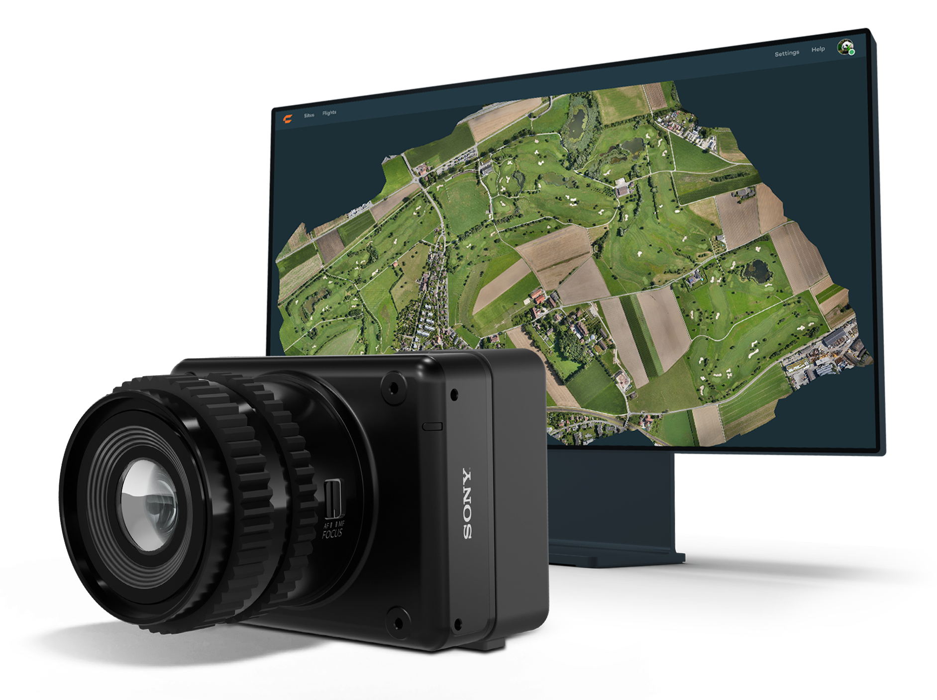
Wingtra has launched the MAP61 mapping sensor, designed to assist professionals in generating larger mapping outputs more efficiently. This ultra-high-resolution sensor offers detailed 3D data in a single pass, providing valuable analytics for vertical assets.
The MAP61 can cover up to 460 hectares (1,140 acres) in a single flight, reducing fieldwork time and enhancing productivity. According to Julian Surber, product manager at Wingtra, the MAP61 can decrease fieldwork time from one hour to approximately 35 minutes while doubling processing speed. This efficiency is beneficial for projects requiring both 2D and 3D data.
MAP61 features oblique sensor configuration, which can facilitate detailed mapping of long structures such as highways without interrupting traffic flow. This design reduces the need for cross-hatch flights, cutting field time in half for vertical resolution and accuracy, which is critical in industries such as construction.
The MAP61 is versatile and suitable for various applications including land management, urban planning, highway mapping and progress monitoring in open-pit mines. Its ability to operate efficiently in challenging environments — such as urban areas or open pit mines —makes it a valuable tool for professionals who need timely data.
The system can integrate seamlessly within an intuitive mapping workflow. Wingtra combines vertical take-off and landing (VTOL) capabilities with its software platform, WingtraCLOUD. This integration allows users to plan, capture and process data without switching between different software applications.
u-blox and Topcon Positioning Systems have formed a strategic partnership to develop a high-precision GNSS positioning service for the mass market.
The partnership was formed in response to the increasing demand for GNSS precise positioning across various applications. According to a recent EUSPA report, services enabled by GNSS devices are projected to generate approximately 80% of total GNSS revenues by 2033.
The comprehensive GNSS correction services will serve a wide range of applications requiring precise positioning, including automotive, industrial, robotics, construction, precision agriculture and mobility sectors. These services will integrate with u-blox’s current and future hardware products, as well as existing services such as PointPerfect.
The increasing prevalence of GNSS spoofing in commercial aviation poses significant safety concerns and highlights the need for robust alternative positioning, navigation and timing (A-PNT) sources. This form of electronic warfare, which uses fake signals to confuse aircraft navigation and safety systems, has become a growing issue for civilian flights worldwide.
Pilots told The Wall Street Journal that spoofing incidents have risen in recent months. According to analyses from SkAI Data Services and the Zurich University of Applied Sciences, the number of affected flights per day increased from a few dozen in February to more than 1,100 in August 2024.
The issue of spoofing has expanded beyond active conflict zones near Ukraine and the Middle East, and now affects hundreds of civilian pilots daily on a global scale. The modern cockpit’s heavy reliance on GPS technology means that falsified data can have far-reaching consequences, breaching multiple aircraft systems and causing disruptions that may last anywhere from a few minutes to an entire flight.
According to anonymized reports shared with government agencies and industry groups, pilots have experienced many alarming incidents, including sudden clock resets, false terrain warnings and unexpected flight path deviations. This surge in GNSS spoofing attacks highlights the vulnerability of critical navigation systems and raises significant concerns about aviation safety in an increasingly complex environment.
All jammed up The Wall Street Journal reported that in August 2024, a United Airlines flight from New Delhi to the New York area encountered a GPS spoofing incident that affected its navigation systems for the duration of the flight.
Initially, the flight seemed to adhere to the standard GPS route across Asia, mirroring the path taken by previous flights heading to Newark Liberty International Airport. The spoofing attack, originating in the Black Sea region south of Ukraine, caused the aircraft’s GPS coordinates to deviate progressively from its actual position throughout the remainder of the flight.
Even after the plane had left the affected area, its reported GPS location continued to show erratic behavior, occasionally making sudden jumps. This suggested that the navigation equipment was struggling to recalibrate accurately. While alternative navigation systems ensured the flight’s safe completion of its intended route, the compromised GPS data indicated that it had terminated in the Atlantic Ocean. In reality, the aircraft landed safely at its scheduled destination in Newark.
Keeping operations safe Aviation safety officials said spoofing has disrupted some flights but has not posed major safety risks. Pilots are trained to use A-PNT systems as backups. However, managing false GNSS signals and alerts risks dividing the operator’s attention if a more severe problem arises.
“If we lose an airplane because of workload issues because of these problems we’re encountering, compounded with an emergency, that is going to be a horrendous event,” said Ken Alexander, the Federal Aviation Administration’s chief scientist for satellite navigation, during a pilot union forum in Washington, D.C.
Airlines are collaborating with aircraft manufacturers, parts suppliers, and aviation safety authorities to devise immediate solutions and long-term strategies. For example, the International Air Transport Association (IATA) and the European Union Aviation Safety Agency (EASA) are openly discussing these challenges and holding workshops to share best practices. Safety bulletins have also been issued for operations where spoofing and jamming are known to have occurred.
Industry insiders told The Wall Street Journal that the development of new equipment standards to enhance civilian aircraft resilience against spoofing attacks is not expected to be finalized until 2025.
Navigating issues across sectors According to anonymized reports collected by OpsGroup, an aviation safety organization that includes pilots, dispatchers and other airline staff, various attacks have caused navigation issues across multiple sectors.
GNSS spoofing has disrupted operations in Europe but has not endangered flights, said Florian Guillermet, executive director of the European Union Aviation Safety Agency. Pilots had to divert to airports they did not intend to land at, and earlier this year, an airline temporarily halted operations at an Estonian airport that was not equipped with ground-based navigation as a backup for GNSS.
Boeing said manufacturers, carriers and regulators globally are contributing GPS expertise for solutions to ensure safety. Boeing and Airbus are working with airlines to help develop procedures to assist pilots, the companies said.
United and American said their pilots are equipped with several ways to navigate with precision, even with GPS interference. American said it has not experienced disruptions or significant safety concerns from GPS interference.
Insights from industry experts
During the 64th Civil GPS Service Interface Committee Meeting — hosted at ION GNSS+ 2024 from Sept. 16-17 — The presentation “Complementing GNSS for Resilient Performance Based Navigation” by Okuary Osechas Ph.D., and Gary A. McGraw, Ph.D., addressed the critical role of complementary positioning, navigation and timing (CPNT) technologies in aviation, particularly in light of increasing threats to GNSS.
The presentation highlights the impact of radio frequency interference (RFI) on aviation, including jamming and spoofing. These pose significant risks to aviation safety by reducing operational margins. The prevalence of these threats is increasing, necessitating alternative navigation solutions.
Performance-based navigation (PBN) is essential for modern aviation, enhancing efficiency and flexibility. However, it relies heavily on GNSS, making it vulnerable to disruptions, again highlighting the need for CPNT services.
Integrating CPNT sources ensures resilient navigation capabilities. This includes leveraging legacy navigation aids and modernized terrestrial systems. Various complementary technologies such as eDME, eLORAN, LDACS-NAV and LEO SATNAV are being assessed for their operational effectiveness, compatibility and potential to support aviation needs.
The researchers recommend the following to address these challenges:
Near-term solutions: Implementing eDME for backward compatibility. Medium-term strategies: Utilizing eLORAN for wide-area time distribution. Long-term goals: Developing LDACS-NAV to enhance spectrum efficiency and standardization. Collaborative efforts: The presentation calls for international cooperation in research and development to advance standards and infrastructure investments in complementary PNT technologies.
Emlid has released updates to its Emlid Flow mobile and cloud app for land surveying. The app now includes a full range of tools for earthworks, topographic and as-built surveys and features such as Surfaces support.
When used with Emlid’s survey-grade Reach GNSS receivers, the upgraded Emlid Flow app aims to improve efficiency for land surveying and construction workflows. Key features added to Emlid Flow include advanced linework capabilities, inverse and traverse tools, polygon support and an auto-collection mode. The recently released Surfaces support allows surveyors to incorporate digital terrain models (DTM) into projects and calculate cut and fill values during stakeout operations.
In developing these updates, Emlid seeks to create an uncluttered, intuitive interface for surveyors while maintaining all necessary controls and functionality. The app offers streamlined navigation and instant cloud syncing, enabling surveying professionals to complete tasks efficiently on their preferred device, whether a rugged Android smartphone or iPad. Projects prepared in the cloud are instantly accessible in the mobile app for field use, streamlining the entire survey process.
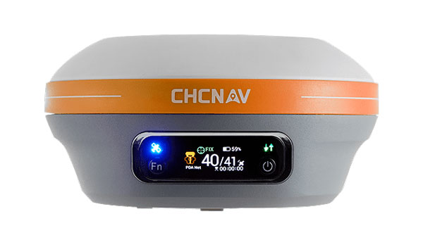
CHC Navigation (CHCNAV) has unveiled the i83 Pro, an inertial measurement unit (IMU)-real-time kinematic (RTK) GNSS receiver. This receiver combines GNSS capabilities with extensive compatibility options to address the diverse needs of surveying, construction and mapping professionals.
The i83 Pro incorporates CHCNAV’s third-generation GNSS antenna and the latest iStar algorithm, designed to boost GNSS signal tracking efficiency by 30%, according to the company. With 336 channels supporting GPS, GLONASS, BeiDou, Galileo and QZSS constellations, it can achieve centimeter-level precision rapidly, even in challenging environments.
The receiver offers comprehensive connectivity options, including built-in Wi-Fi, Bluetooth, NFC, 4G modem and UHF modem. These technologies support various GNSS surveying modes, such as RTK Networks NTRIP and UHF base-rover configurations. The i83 Pro is compatible with VRS, FKP and MAC for Network RTK for precise positioning across diverse operational settings.
Engineered for challenging environments, the i83 Pro features an IP68-rated enclosure for dust and water protection, a compact and lightweight design for enhanced portability, a high-resolution color display for clear status information and a 20-hour battery life for continuous operation in rover mode.
The i83 Pro offers optional Trimble RTX and OmniSTAR support, providing RTK-level accuracy without relying on a base station or VRS network. Additionally, it can be equipped with the optional Trimble MAXPro Positioning Engine for extended performance.
CHCNAV will showcase this receiver at INTERGEO 2024 in Hall 3, Booth B3.052.
Safran Navigation and Timing has unveiled its latest GNSS simulator, the Skydel GSG-8 Gen2, an evolution of its GSG-8 simulator. This new positioning, navigation and timing (PNT) test solution is part of Safran’s family of Skydel-based simulators.
The GPU-based GSG-8 Gen2 simulator delivers high-end GNSS signal testing capabilities in a user-friendly, turnkey package. It seeks to support the growing demand for location-aware applications and systems requiring navigation or timing.
It features six front-facing RF outputs and a combined output. It covers the entire GNSS bandwidth and offers a 1,000 Hz simulation iteration rate, high dynamics, real-time synchronization and simulation of all-in-view satellite signals.
This simulator is ideal for development, NavWar testing and integration projects that require high performance, increased constellation and satellite visibility and multi-vehicle/multi-antenna scenarios. It allows users to generate RF signals that simulate real-world receiver device reactions under user-defined parameters. Users can control various simulation aspects, including receiver trajectories with six degrees of freedom (DoF), multipath signals, advanced jamming and spoofing and atmospheric interferences.
The simulator can recreate various types of interference, both benign and malicious. Users can adjust power levels, interference signal types, spoofing signals, location, antenna patterns, and transmitter trajectories. In-band and out-of-band jamming signals can be generated without additional hardware.
The GSG-8 Gen2 can simulate up to 2,000 GNSS signals simultaneously across multiple bands, leveraging GPU power to overcome the limitations of FPGA-based simulators. A single GSG-8 Gen2 can run and control multiple instances, each representing an independent trajectory, vehicle or antenna with its own output connector.
As a low-Earth orbit (LEO) PNT signal simulator, the GSG-8 Gen2 can generate many signals required for LEO PNT simulations alongside legacy GNSS signals, threats and multipaths. It also supports S-Band signal generation.
SpaceX has launched the latest pair of Galileo satellites from the Kennedy Space Center in Florida. The SpaceX Falcon 9 rocket carried satellites 31 and 32 (FM26 and FM32) to their designated orbits.
This launch, number 13 in the Galileo program, marks a crucial milestone in the constellation’s development. The addition of these satellites completes the designed constellation, with the required operational satellites plus one spare per orbital plane. The new pair will undergo testing at their final altitude of 23,222 km before becoming operational.
European Space Agency (ESA) Director of Navigation Javier Benedicto highlighted the importance of this launch, stating that the remaining six Galileo First Generation satellites are scheduled for deployment in 2025 and 2026.
These additional satellites are designed to enhance the system’s performance and reliability further, ensuring uninterrupted delivery of highly precise navigation services.
At ION GNSS+ 2024, Eric Châtre, head of EU GNSS exploitation and evolution at the European Commission, and Miguel Manteiga, Galileo project manager at ESA, participated in a panel titled “Status of GPS, Galileo, BDS, QZSS, KPS and NavIC.” They shared how 2024 has been a particularly eventful year for the Galileo program. In April, satellites 29 and 30 were launched and entered service in September. The new Public Regulated Service (PRS) signals began broadcasting, offering encrypted navigation for authorized governmental users. A significant upgrade of Galileo’s ground segment was completed without impacting users.
The Galileo system continues to evolve, with the development of Second Generation (G2) satellites underway. These satellites will feature fully digital navigation payloads, electric propulsion and inter-satellite link capacity.
Change from one generation of GNSS receivers to the next is generally evolutionary, not revolutionary. As with other technologies, it follows a feedback loop between end-user requirements and technical advances. Additionally, GNSS receivers can now take advantage of four full GNSS constellations, two regional ones, and a plethora of corrections/augmentation services — and increasingly must be able to counter jamming and spoofing.
To get the perspective of GNSS receiver manufacturers on these issues, I asked four questions to the following company representatives:
For longer versions of their responses, as well as responses from additional companies, visit here.
Question: What is currently the best way to take full advantage of the large number of GNSS satellites — four full constellations and two regional ones — and of the many corrections/augmentation services?
Korsakissok: Many satellites in view means greater precision in urban areas, where the view of the sky is partially masked, better resilience to adversity (jamming, spoofing, constellation disruption) and, more generally, greater precision even with a clear view of the sky, thanks to local augmentations. Users working on autonomous vehicles are asking for these advantages, with the goal of achieving a certified and secured system. Technically, to have an optimal usage of this multiplicity of satellites and signals, a receiver should be able to make a fix, even with one or two satellites of each constellation in view, as we do at Syntony. Practically, because of the heritage, it is not so often the case: Many receivers, even today, make a position, velocity and time (PVT) calculation with GPS first and then use the other signals to improve it.
Lopez: To fully leverage all GNSS constellations and regional systems, it is essential to utilize multi-constellation and multi-frequency receivers that significantly enhance accuracy and reliability. These advanced receivers not only improve performance by accessing a broader range of satellite signals but also ensure consistent positioning in challenging environments, such as urban areas with tall buildings or rural regions with obstructed views of the sky.
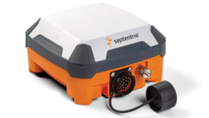
Septentrio’s antarx is a rugged GNSS/INS multi-frequency smart antenna. (Photo: Septentrio)
Some GNSS manufacturers limit signal usage due to inadequate hardware that cannot track multiple signals and their desire to reduce costs (e.g., CPU power or the number of signal tracking components). Effectively tracking multiple signals and constellations necessitates a robust hardware architecture as well as efficient algorithms that can operate optimally in compact embedded systems to fully leverage all available signals in space. At Septentrio, we prioritize maximizing all available signals to deliver the best possible performance for users while ensuring that our solutions remain valuable and accessible for a variety of applications.
Utilizing multiple GNSS signals not only enhances accuracy, availability, and reliability but also improves resilience and GNSS security, offering crucial protection against jamming and spoofing — issues that are becoming increasingly critical for many applications. Moreover, manufacturers must prioritize compatibility with various correction systems, which provide real-time data to improve positional accuracy further. Ensuring that receivers can seamlessly integrate with multiple correction services allows for smooth adoption across diverse market applications, catering to the unique needs of different industries.
To meet market demand, Septentrio has developed the Agnostic Corrections program, enabling customers to select from a range of well-established and affordable correction services. This approach offers flexibility and access to key service providers in the industry. Since these services support various signals, the advantage of our receivers is key to accommodate the wide array of signals and format messages used by these correction services.
At Septentrio, optimizing these elements is central to our vision and strategy for GNSS core technology. By focusing on performance, reliability, and compatibility, we aim to deliver innovative solutions that meet the evolving demands of the market while maintaining our commitment to excellence in GNSS technology. This strategic approach not only enhances the user experience but also positions Septentrio as a leader in the GNSS field.
Wang: To fully benefit from commercial PPP corrections, receivers must be capable of receiving signals from all GNSS constellations and frequency bands, and support SBAS and L-band services. On the software side, optimizing GNSS satellite utilization involves feeding the navigation filter with a wide range of observations from each available constellation. This, combined with adaptive interference mitigation algorithms and receiver autonomous integrity monitoring (RAIM) techniques, can greatly enhance the robustness and resilience of GNSS solutions in challenging environments such as urban canyons, interference, and spoofing.
Farrokhi: Regional services are categorized as augmentation systems. They are offered through both satellites and terrestrial systems. Satellite-based augmentation systems include but are not limited to SBAS, WAAS, AGNOS, MSAS, GAGAN, NavIC and QZSS. Terrestrial augmentation systems include but are not limited to GBAS, and GLS. Correction services include but are not limited to RTK and PPP.
Supporting these regional and correction services along with multi-band support increases the complexity of the receiver hardware and associated firmware. It is important to note that not every application or use case requires all these different services. For instance, asset tracking utilizing battery-operated tags do not require correction services or L5 acquisition. Low-power operation and simplicity of the GNSS receiver is key to longevity of operation in such applications.
The selection of correction service is highly dependent on the type of communication pipe supported by the hardware. For instance, L-band capability is required for satellite-based correction services, whereas LTE is needed for terrestrial based services.
Ching: I think one of the best ways is to embrace all the available signals on hand. What that means is with the luxury of redundancy, the system can select the best signals to use into the position estimation algorithm. Our OEM7 uses multiple constellations (GPS, GLONASS, Galileo, BeiDou, QZSS and NavIC) and multiple frequency bands (L1, L2, L5 and E6).
Q: Are the requirements for different end user applications — for example, surveying vs. fleet tracking — still very different or are they converging as capabilities increase?
Cerber CRPA Receiver with four-channel antenna and Constellator CRPA simulator. (Photo: Syntony)
Korsakissok: In a way, everybody is benefiting from better precision year after year, using the standard open signals; related to that, we can say that the solution capabilities are converging. A bit. However, we do not see everybody converging toward a “high precision real-time PVT every time everywhere.” Bringing 20-cm precision to a truck-tracking application is nice, but nobody will ever want to pay for this, if it is not relevant for how they use the application. Conversely, for precision agriculture, precision mining and autonomous vehicles, it will always be required, and they will be able to pay for the precision, when associated with reliability, in order to achieve the targeted level of safety.
Lopez: Although GNSS technology has evolved significantly in recent years due to the growing demand for accuracy across new applications, the requirements among different applications remain highly varied. Some may need centimeter-level precision, while others are satisfied with accuracy within 10 centimeters. Survey-grade applications still demand millimeter-level accuracy, while certain autonomous systems may only require 1 to 10 centimeters of precision. Additionally, the environments in which these applications operate vary, such as a surveyor working in unobstructed ground conditions versus a drone navigating through complex airspaces, where jamming, signal availability, and interference can affect performance.
The increasing number of applications that rely on accuracy has resulted in diverse requirements across the board. This is why customers seek more flexible GNSS receivers to balance availability, accuracy, and reliability based on the specific use case. There’s a broad spectrum of needs — not only in GNSS performance (accuracy, time to fix, reliability) but also in security (anti-jamming, anti-spoofing, cybersecurity) and hardware design. For example, some users need compact solutions for small form-factor devices, while others prefer robust systems that can endure harsh environmental conditions. A surveyor, focused on achieving high accuracy, may not need the same GNSS resilience required by critical infrastructure or autonomous systems, where safety mechanisms are crucial.
As more prosumer and innovative applications advance, their needs differ from those of industrial or critical-use cases. At Septentrio, we offer solutions that fill the gaps when lower-end options fall short, attracting customers dissatisfied with third-party products that fail to meet their needs. Septentrio also provides enclosure solutions with stringent environmental protection requirements, including water resistance, humidity control, vibration tolerance, and corrosion resistance.
While GNSS technology continues to advance and become more sophisticated, we also see that the gap between different applications is narrowing. Fleet tracking, for instance, is beginning to benefit from more precise positioning and the ability to use multiple GNSS constellations for autonomy — features traditionally reserved for high-precision applications such as surveying. The cost of high-precision GNSS receivers is also decreasing, making advanced features more accessible across various industries.
However, this increased autonomy introduces new demands, such as top performance and safety in complex environments, and seamless integration with sensor fusion and other ecosystems. Traditional GNSS receivers used for basic fleet tracking will not meet the needs of these advanced use cases, even if they remain part of the same vehicle or platform.
In summary, despite a trend toward the convergence of GNSS capabilities that enhance accuracy, the core requirements of these applications remain distinct, challenging the industry to develop more universally applicable solutions.
Wang: From our point of view, while GNSS performance is steadily improving, manufacturers still need to strike a balance among cost, accuracy, and availability to meet the diverse requirements of different user applications. In surveying, for example, accuracy is the top priority, while in transient control, integrity and availability are more critical. Although GNSS capabilities are increasing and some convergence of requirements is occurring, significant differences remain, necessitating careful design and optimization by manufacturers to address these varying needs.
Farrokhi: The requirements for surveying, for instance, do not apply to the rest of the market. For surveying, extreme accuracy is a must, hence utilizing RTK services and the cost of the solution is usually high. On the other hand, asset tracking, for instance, can benefit from high sensitivity, low power, low cost and cloud processing to reduce power consumption in the asset tracking device.
Generally speaking, the GNSS market falls into the following categories:
Low power, low cost — such as asset tracking
High precision — e.g., surveying and agriculture
High precision, with high reliability — such as ADAS
High speed, high G — in defense applications
Anti-jamming and anti-spoofing — such as in avionics and defense
etherWhere’s next generation hardware solution enables the convergence of all these disparate applications onto one hardware platform by utilizing flexible software and cloud processing.
Ching: Ultimately, regardless of applications, users want the reported positions that are accurate with trustworthy quality indicators. As capabilities increase, I expect more requirements to converge. For example, both surveying and fleet-tracking applications need to operate during ionospheric scintillations. Having a robust positioning solution in both applications is essential. Hexagon | NovAtel released updated firmware (versions 7.09.01 and 7.09.02) in April 2024 to increase ionospheric resilience.
Q: What is the best way to integrate complementary sources of PNT — such as LEO satellites and ground-based systems — into end user hardware and software, to maximize resilience during GNSS disruptions or outages?
Korsakissok: Such integration will be eased for all the new sources that can be acquired with the same RF stages, meaning mostly L-band as of today. SBAS has paved the way and emits at the same carrier frequency as the classic GNSS. U.S. and European low-Earth orbit positioning, navigation and timing (LEO-PNT) projects have included such signals in L-bands, and other telecom constellations can also be used that way (Inmarsat, Iridium, etc.). Because of this, all these L-band extensions to classical GNSS will be the first in line on everybody’s roadmap. When C-band signals will be emitted by GNSS constellations, then telecom ones could also be easily integrated. However, that will take many years.
Lopez: To enhance resilience during GNSS disruptions or outages, integrating a multi-layered approach with complementary sources of positioning, navigation, and timing (PNT), such as LEO satellites and ground-based systems, into end-user hardware and software is crucial. While GNSS technology will remain essential, the combination with other technologies such as inertial sensors and sensor fusion will become increasingly important as these solutions become more available.
Although alternative PNT mechanisms can bolster resilience, the strengths and protections at the core of GNSS are vital for many applications, especially since GNSS manufacturers possess the expertise to address jamming and spoofing effectively. This layered security approach resembles the “onion model” in cybersecurity — adding more security layers enhances protection against disruptions.
While LEO technology is advancing, its full value for PNT may take a few more years to materialize. In the meantime, other sensor technologies, such as inertial navigation systems (INS), already provide significant benefits in the absence of GNSS or in the most difficult conditions to GNSS.
At Septentrio, we are committed to developing products that invest in sensor fusion technologies (GNSS/INS), and we actively participate in key LEO programs that promise substantial improvements in resilience and other PNT aspects, including GNSS corrections and enhanced multipath mitigation for optimal performance in challenging environments. We view this evolution as critical to our product roadmap and consider it a strategic priority for our company.
Wang: The foundation of an effective positioning system is robust hardware that supports the integration of multiple PNT sources. Building on this multi-source signal base, a set of advanced algorithms is necessary to selectively use the signals and filter out interference, enabling the seamless fusion of these sources and achieving superior performance. Moreover, redundant and backup filters are crucial for maintaining the robustness of the positioning solution, particularly during GNSS disruptions or outages.
Farrokhi: etherWhere’s next-generation solution supports LEO constellations such as Xona Space to enhance location tracking and provide resilience and redundancy. LEO satellites signal strength is higher than GNSS satellites due to their lower orbit and as such provide better link margin. The key to ubiquitous adoption is in a well-integrated single chip solution at lower power consumption.
Ching: Complementary sources of PNT must be proven to provide a consistent improvement in positioning performance, beyond what GNSS alone can provide. For example, increasing availability is not helpful if the quality indicators cannot be trusted. The integration must be an overall benefit to the user, in terms of ease of use, positioning performance and reliability. Our team is already leading the market and working with key stakeholders and partners to provide PNT beyond GNSS as we announced in previous years.
Q: What are the key innovations in your latest receiver or generation of receivers?
Korsakissok: Syntony is well-known to have one of the first full SDR embedded receivers, working in multi-frequency and multi-constellation mode. Thanks to that, we were able to be the first to demonstrate the coupling with XONA, at ION GNSS in 2022, and have been chosen by the European Space Agency (ESA) for their own LEO PNT: Flexibility and ease of modification are the major advantage of full SDR, versus ASICS.
Today, our SDR receiver is embedded in cars, trains, UAVs, launchers and satellites, but also in trucks for underground mining, together with our SubWAVE solution. Not to mention our CRPA version, which is capable of state-of-the-art anti-jamming level, completed by exclusive anti-spoofing mitigation, as we can compare, directly inside the receiver, the direction of arrival of all GNSS signals with the ephemeris, avoiding retaining and tracking the ones that are spoofed.
Lopez: This year, Septentrio has achieved notable advancements in GNSS receiver technology by enhancing resilience against jamming and spoofing and by launching the AntaRx product line. It offers high-precision performance, a durable design, and versatility for industrial applications, such as construction and mining. With advanced anti-jamming and anti-spoofing across all products, plus the AntaRx — which is an all-in-one GNSS, antenna, and sensor fusion solution — we remain committed to delivering the most reliable positioning in the most challenging environments.
Lopez: In response to evolving market demands and guided by our strategic vision, Septentrio has made significant advancements in GNSS receiver technology, focusing on two major pillars: resilience and performance.
Resilience: Septentrio has established a reputation for providing robust GNSS solutions thanks to our AIM+ technology, and we remain committed to enhancing resilience across our product line. Our latest innovations have significantly improved our receivers’ ability to detect and mitigate spoofing attacks. These enhancements have been validated through rigorous testing, including recent GNSS jamming tests conducted in Norway (see Norway results here), as well as field applications where our receivers have successfully operated in contested environments, particularly within drone applications. This continued focus on resilience ensures that our customers can rely on our technology even in challenging conditions where signal integrity is paramount.
AntaRx Product Portfolio: This year, we proudly launched the AntaRx product line, specifically designed to meet the rigorous demands of industrial applications such as construction, mining, and robotics. The AntaRx series offers a variety of configurations, including single-frequency, dual-frequency, and inertial variants (GNSS/INS), providing unparalleled flexibility for a wide range of use cases (see more about this product here).
What sets the AntaRx apart is its exceptional high-precision GNSS performance combined with core reliability. This product line is compatible with various correction services, allowing users to achieve optimal accuracy regardless of their operational environment. Moreover, the AntaRx features advanced anti-jamming and anti-spoofing technologies, which are critical for ensuring the integrity of positioning data in areas where interference is prevalent.
In addition to its technological innovations, the AntaRx is designed with ruggedness in mind. It is built to withstand harsh environmental conditions, making it suitable for deployment in demanding industries. The user-friendly interface simplifies operation and enhances the user experience, ensuring that both seasoned professionals and newcomers can easily integrate the technology into their workflows.
Furthermore, the AntaRx incorporates sophisticated sensor fusion capabilities, combining GNSS with inertial data to enhance overall positioning accuracy and reliability. This integration is particularly beneficial in environments where GNSS signals may be obstructed or unreliable. The careful design of the AntaRx, which includes an integrated antenna and GNSS components, significantly improves multipath mitigation, further ensuring optimal performance even in challenging conditions.
In summary, Septentrio’s commitment to innovation is evident in our latest GNSS receiver developments. By focusing on resilience and advanced capabilities, particularly with the launch of the AntaRx product line, we aim to provide our customers with the most reliable and high-performing GNSS solutions tailored to meet the diverse demands of various industries. As technology continues to evolve, we will remain dedicated to enhancing our products to meet the future challenges of positioning, navigation, and timing.
Wang: Our newest product, the RS10, leverages cutting-edge technologies to achieve seamless integration of GNSS with SLAM, vision, and INS. This fusion has resulted in the RS10 delivering enhanced accuracy and reliability while providing an exceptionally efficient solution for the surveying and mapping industries. By combining these complementary technologies, we’ve made a significant leap forward in advancing the performance and capabilities to benefit geospatial professionals.
Farrokhi: At etherWhere, we have innovated on multiple fronts to address different use cases.
These innovations include:
AccuWhere Cloud to address the requirements for low-power, battery-operated asset trackers.
Hybrid Constellation to address the simultaneous processing of the four GNSS constellations along with LEO signals of opportunity (SOP) to provide resilience and redundancy.
ArrayNav adaptive multi-antenna system for anti-jamming applications such as avionics and also applications that require elimination of multipath such as autonomous driving.
Ching: In addition to the latest firmware update announcement to combat ionospheric scintillation, Hexagon | NovAtel also rolled out the latest office software version (NovAtel Application Suite v 2.0) for providing the next-level GNSS interference monitoring insight to users to make informed decisions to maintain robust positioning. In parallel, NovAtel has been developing the functional safety positioning engine and correction services that meet ISO 26262 standard as we anticipate the automotive world not only needs a positioning solution that is accurate and resilient, but is also safe to use.
Mitch Narins’ answer to the question, “If not GNSS, then what?” in the August 2024 issue’s EAB Q&A column, conveys an important message. As a result of their quality and availability, services offered by GNSS create dependencies and subsequently the expectation that of course they must always be there. However, recent experiences have shown we cannot rely on that expectation because either natural or hostile occurrences can disrupt GNSS services, no matter what measures are taken to protect them. That is why the U.S. Department of Defense (DOD), in its “Strategy for the DOD PNT Enterprise,” assessed that, “To combat man-made and natural threats to GPS, other sources of PNT information will be necessary to assure continuous PNT service …”
The strategy describes a layered PNT architecture using global (GPS), regional (eLoran), and local (or self-contained) sources of PNT information. It states, “The global PNT layer is space-based and available worldwide. The regional PNT layer may be implemented in areas … where PNT resiliency must be assured with backup capability. The local layer provides PNT information using man-made and natural information sources available for a limited time or over a limited area.” To achieve resilience from this layered architecture, the strategy provides an integration concept in which GPS and other GNSS are individually integrated with PNT information from the other layers into resilient applications to operate through the hostile environments they will encounter.
Unfortunately, the U.S. government is ignoring a major piece of this layered strategy in favor of space-based and local or self-contained solutions, as it has dismantled virtually the entire legacy Loran infrastructure in the United States and completely in Alaska, although GPS backups are lacking in the Arctic and northern Pacific regions. The loss of the Alaska sites is particularly concerning as the Arctic and northern Pacific Ocean coverage they would provide is a valuable backup to vulnerable GPS signals at a time when other nations are eying the sea lanes north of Alaska/Canada and conducting excursions around the Aleutian Island chain and the Alaskan coast. Coincidentally, the DOD has just published a new “Arctic Strategy,” which requires availability of PNT from GPS (at least) for its success, though “PNT” is not mentioned. However, without effective PNT, whether from GPS or other sources, the systems on which the strategy depends will fail.
As Mitch notes, there are those GNSS advocates who see strengthened GPS/GNSS as the best answer – but real-world events highlight the need for diversification, and now other nations are expanding their Loran-based regional systems. For its Arctic interests and domestic critical infrastructure as well, the U.S. must wake up to reality and do the same.
Adtranhas launched its Oscilloquartz Time Scale System, designed to meet the precise timekeeping requirements of national metrology institutes, scientific research facilities and other applications demanding the highest levels of accuracy and traceability.
The comprehensive system integrates Adtran’s Oscilloquartz grandmaster clocks, GPS/GNSS receivers, and high-performance optical cesium atomic clocks alongside a combination of the phase comparator, reference generator, and time interval counter. This ensures synchronization with coordinated universal time (UTC) and provides robust protection against cybersecurity threats.
With its customizable design, real-time monitoring, and seamless transition capabilities, the Oscilloquartz Time Scale System addresses the increasing need for resilient and accurate time synchronization across various sectors to ensure operational continuity and data integrity.
Leica Geosystems, a part of Hexagon, has introduced the Leica iCON trades solution, which includes the iCS20 and iCS50 sensors designed for construction layout tasks. This solution integrates with existing Leica iCON build portfolio tools, offering tailored workflows for construction industry users.
The solution features the Leica vPole, allowing free movement during measurements. It works with the iCS50 to lock to the vPole using a unique combination of dot and stripe patterns. This system can automatically detect pole height and compensate for tilt, facilitating accurate point and line layouts even in difficult-to-reach areas. These features are designed to increase efficiency and precision in construction workflows.
Leica iCON trades has Hexagon’s 6-degree of freedom (6DoF) technology, traditionally used in industrial measurement, to the construction sector. This seeks to broaden the scope of applications in construction, offering new possibilities for improving workflow efficiency and ease of use.
The solution is designed for quick and efficient layout tasks, leveraging artificial intelligence (AI) to tackle current industry challenges. Features include computational photography for advanced imagery and realistic site documentation, while AI capabilities predict pole movement to enhance target lock and tracking, thereby streamlining the layout process.
Rx Networks, a GNSS data services provider, has released TruePoint | LITE, a correction service designed for power-conscious applications that require precise and reliable location data.
TruePoint | LITEaims to deliver sub-meter and lane-level accuracy with global coverage for low-power usage. It is engineered with power efficiency in mind, focusing on applications such as smartphones, wearables, asset tracking and Internet of Things (IoT) devices.
TruePoint | LITE uses patent-pending predictive technologies designed to reduce dominant GNSS ranging errors—including ionospheric, orbital, and clock errors—to ensure accurate GNSS positioning while minimizing data traffic and conserving battery life.
TruePoint | LITE leverages proprietary predictive technologies to correct key GNSS ranging errors, particularly ionospheric range errors, according to the company.