Propeller, a cloud-based worksite mapping and UAV analytics company, has partnered with GEODNET to upgrade its survey-grade mapping solutions. By integrating GEODNET stations into the Propeller Corrections Network, Propeller can now deliver more precise data to its users in the construction, mining, aggregates and waste management industries.
Propeller has developed a fully integrated post-processing kinematic (PPK) mapping workflow for various commercial UAVs. Surveyors and contractors can visualize geospatial data from one central system using AeroPoint GPS-enabled smart ground control points and Propeller’s cloud-based platform.
GEODNET’s global network of more than 9,000 registered full-constellation GNSS reference stations offers Propeller users the GNSS corrections data needed to align AeroPoints and UAVs to thousands of published coordinate systems.
Propeller has completed the initial integration of GEODNET stations into its network, allowing both existing and new customers to benefit from these enhancements immediately.
u-blox has introduced CloudTrack, an end-to-end asset tracking service designed specifically for Internet of Things (IoT) applications. This comprehensive solution integrates ultra-low-power positioning, global connectivity and cloud integration into a single platform. CloudTrack aims to simplify IoT asset tracking by offering flexible, contractless per-location-request plans available worldwide, allowing users to manage their assets effortlessly.
CloudTrack offers six times the energy savings compared to a standalone GNSS fix with a cold start while securely transmitting data over the internet. The system intelligently calculates position using a combination of data from GNSS, cellular, and Wi-Fi sources. This capability allows users to locate assets even in areas with poor or non-existent GNSS signal conditions and indoors, where obtaining a location fix can be challenging.
With a single Thingstream SIM card operating globally, IoT devices can utilize one stock-keeping unit (SKU), eliminating the need for regional SKUs. The Thingstream cloud platform seeks to make it easy for businesses to transform and integrate their data with tracking dashboards, major cloud platforms and enterprise backend systems.
China’s BeiDou high-precision navigation and positioning service platform has entered trial operation, The National Geomatics Center of China reported.
Developed under the leadership of the Ministry of Natural Resources, the platform integrates satellite navigation and positioning base stations nationwide within the natural resources system. This initiative consolidates more than 3,300 base stations into a unified network, offering centralized management of station resources.
The network offers seamless, high-precision positioning services nationwide, delivering real-time, accurate and reliable navigation for sectors including public welfare mapping, resource surveying, intelligent transportation, autonomous driving, precision agriculture and social governance.
The service is available both online and offline. Online, it offers real-time observation data and enhanced positioning services. Offline, the platform delivers coordinate results, post-event observation data files, and related products.
The BeiDou Navigation Satellite System (BDS) was initiated in 1994. The construction of BDS-1 and BDS-2 was completed in 2000 and 2012. When BDS-3 was completed and put into service on July 31, 2020, China became the third country to have an independent global navigation satellite system.
Topcon has released a new version of its computer-aided design (CAD) software suite, formerly known as MAGNET. With enhanced features and workflow improvements to the Office, Field and Tools modules, version 9 is also renamed under the Topcon software suite as the business retires the MAGNET brand.
The software is designed for professionals such as surveyors, engineers, modelers, estimators, and project managers, aiming to improve productivity through integrated software capabilities and workflows. It can be used as standalone, office-based CAD software or as a cloud-connected solution that integrates field and office operations with Topcon or Sokkia survey instruments. The platform offers user-friendly and versatile configurations suitable for various applications.
Topcon Office version 9 introduces new options for working with digital terrain models (DTMs), spot elevations and offset capabilities, enhancing versatility when handling 2D or 3D data sets. Improvements in Topcon Field include better productivity and stake reporting capabilities, advanced resection functionality for unknown control points, and a new offset routine for creating points that are not observable with a total station. Both Field and Office modules now support direct import and export with 12D XML file formats.
Subscribers to the AllDayRTK high accuracy positioning network can now directly import and export RINEX data into Topcon Tools with a current Plus or RINEX subscription. Version 9 of Topcon Tools also features improved coordinate system functions, new traverse calculations, viewing options, and enhanced functionality for working with data in tabular view for reporting.
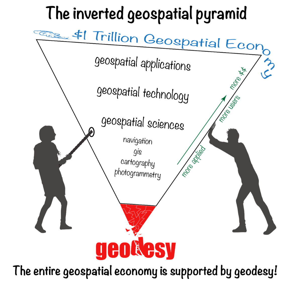
My previous newsletter highlighted activities associated with the Transportation Research Board ADK70 Standing Committee on Geospatial Data Acquisition Technologies. As I mentioned in the newsletter, Linda Foster, ESRI and president-elect of the National Society of Professional Surveyors (NSPS), highlighted how geodesy and surveying provide the foundation for digital twin products. Similar to the inverted geospatial pyramid depicted in my February 2022 GPS World newsletter, Foster’s presentation highlighted that geodesy is at the base of an inverted triangle. See my February 2022 and August 2024 newsletters for more details. Both diagrams emphasize the importance of geodesy and surveying in creating geospatial products and services.
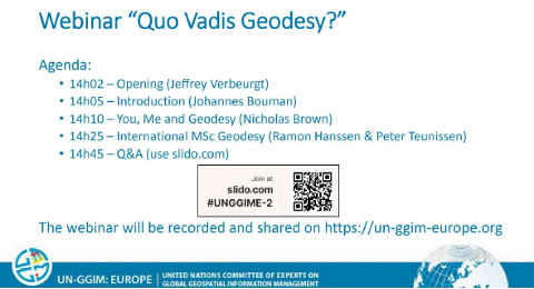
That said, on August 20, I had the opportunity to participate in the UN-GGIM: Europe webinar series: Quo Vadis Geodesy? webinar. Quo vadis is a Latin phrase meaning “Where are you going?” The webinar highlighted the importance of geodesy and the need for more trained geodesists. This is a topic that I have been highlighting for several years.
Agenda for webinar. (All photos courtesy of UN-GGIM: Europe webinar.)
Webinar write up
Modern society relies heavily on satellite services for various critical functions, including economic development, the operation of critical infrastructure, and defense applications. Despite their clear and proven significance, these satellite services are at risk of degradation or failure due to the lack of resources provided to the global geodesy supply chain. It is crucial for decision-makers to understand the far-reaching implications of not strengthening this supply chain, which impacts societal, economic, and environmental applications. Additionally, these decision makers need clear pathways to address these vulnerabilities effectively.
The Community of Interest on Geodetic Reference Frames – Europe, established by UN-GGIM: Europe, is dedicated to supporting the sustainment and growth of the geodetic profession. To address current knowledge gaps, we have organized this webinar featuring two insightful presentations. The first presentation will discuss the risks associated with weak geodetic foundations and their potential to compromise satellite services. The second presentation will introduce an initiative to launch an international Master of Science in Geodesy, emphasizing the importance of formal geodesy education in building robust geodetic foundations.
There were three objectives of the webinar:
1) Provide geo-experts resources to help them convincingly communicate and advocate for a strong global geodesy supply chain.
2) Inform decision makers of the risks of not strengthening the global geodesy supply chain.
3) Support the initiative of the IDEA-league universities to establish an international Master of Science in Geodesy.
The webinar was recorded and can be found here. The presentations can be downloaded from the following weblinks:
This newsletter is going to highlight some interesting items from the webinar, but I would encourage everyone to listen to the recording to obtain the full discussion.
First, I would like to note that Ramon Hanssen included the geospatial inverted pyramid (designed by Dana J. Caccamise II, NGS Regional Geodetic Advisory) and the white paper titled “The Geodesy Crisis” (prepared by Mike Bevis collaborating with others) that documented the concern about the lack of trained geodesists in the United States (see February 2022 GPS World newsletter). Based on the presentation by Ramon Hanssen it appears that the lack of trained geodesists is also a concern of the European geospatial community.
Image: Dana Caccamise II
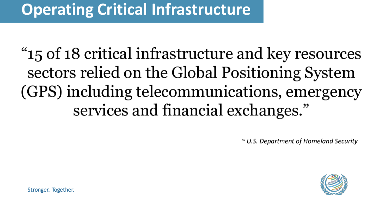
Nicholas Brown, Head of Office, United Nations Global Geodetic Centre of Excellence, did a nice job of explaining the importance of geodesy in everyday activities. He highlighted how GNSS is a critical infrastructure for telecommunications, emergency services, and financial exchanges. In my opinion, GNSS and geodesy are unsung heroes of everyone’s daily activities.
He provided a scenario that would affect almost everyone in their daily routines.
Imagine a scenario without GNSS.
This highlights the importance of geodesy and the need to increase the number of trained geodesists in the world. My July 2020 “First Fix” article in GPS World discussed the need to increase the number of trained geodesists in the United States, and it appears the same issue is a concern of many individuals in Europe. Ramon Hanssen and Peter Teunissen, TU Delft, presented a way forward for Europe. The following are some highlights of the presentation but, again, I would encourage readers to download the slides and webinar for more details.
The presentation described “The IDEA League,” which is a strategic alliance between five European universities of technology: TU Delft, ETH Zurich, RWTH Aachen, Chalmers University, and Politecnico di Milano. One goal of the partnership is to re-establish Europe as a technological and scientific leader by integrating academic resources and knowledge. The concept includes pooling resources for collaborative and complementary programs for teaching students and researchers.
The alliance established an initiation team to develop a proposal that included the following:
Establish a joint international European MSc program in Geodesy.
Combine resources of universities, scientists, and educators in Europe.
Respond to the urgent need for academic geodesists.
Inspire collaboration via complementary fields.
The group sent a questionnaire to stakeholders in the geodetic job market to obtain an understanding of the need for trained geodesists. The responses to the questionnaire highlighted the urgent need for more trained geodesists. Two important responses by stakeholders were (1) 72% perceived the current availability of MSc graduates in geodesy to be unsatisfactoryand (2) 83% expects the demand for (academic) professionals with expertise in geodesy to grow in the foreseeable future.
As mentioned above, 72% perceived the current availability of MSc graduates in geodesy to be unsatisfactory. The questionnaire asked, “What challenges or gaps do you face in recruiting qualified geodetic professionals?”
There were many responses to this question; the image below provides a few examples that were presented at the webinar.
The stakeholders provided reasons why they believe that the demand for geodesists will increase in the future. The list below provides a breakdown of the reasons provided by the stakeholders. The top two reasons were technological advancements and digital transformation. Concerns with consistency in the digital delivery of geometric products were highlighted in my August 2024 newsletter.
We now live in a world where everything is digital. Today, most surveying and mapping instruments collect and generate data in digital format. This paradigm has affected how surveyors, geodesists, and engineers provide their products and services. So, it makes sense that advancements in technology and the transformation of digital data would be important to stakeholders.
The stakeholders were asked their opinion on what expertise is needed by geodesists to meet their requirements. The image below shows the responses of the stakeholders. There were six expertises that exceeded 50%:
Quality (Precision, Accuracy) – 75.8%
Sensors and Techniques – 63.6%
Data Analytics – 60.6%
Mathematical Fundamentals – 58.6%
Reference Frames – 58.6%
GIS and Geo-Databases – 52.5%
The group provided a preliminary program design for a MSc Geodesy. See the image below.
Draft overview MSc Geodesy.
As in all partnerships and collaborations, there are challenges. The group is working together to overcome these challenges. The stakeholders could help by supporting the IDEA League concept and proposal.
Nicholas Brown’s presentation, “You, Me and Geodesy,” provides information that others can use to explain how the global geodesy supply chain is fundamental to what they do and how critical it is to our daily lives. He describes five weaknesses (see the box titled “Weakness in Geodetic Message”) that need to be addressed to improve the message of why it is important to increase the geodetic capacity in the world. I have provided a short summary below, but readers should listen to the webinar for more details.
Evidence – There is no clear, understandable evidence to explain the importance of investing in geodesy to decision makers.
Resources – Leadership cannot make the business case to invest in geodesy without good evidence.
Awareness – There is a need to communicate the importance of geodesy to other science agencies and scientists in different fields of study. For example, climate change is highly dependent on geodesy for measuring sea level rise, changes in gravity, ice melt, and the location of Earth’s center of mass.
Capacity – Capacity development in geodetic science needs to be strengthened everywhere not just in developing countries.
Governance – The scientific geodetic community has done an exceptional job of managing the geodetic infrastructure (e.g., International Association of Geodesy) but they are expected to do too much. During Nicholas Brown’s presentation, he mentioned that, in his opinion, an improved governance model could help advance geodesy around the world. He mentioned the need to have a governance model like the World Meteorological Organization (WMO). WMO members contribute resources to the organization, technical commissions are established to address issues, and operational support and resources are provided to implement capacity development programs.
Weakness in geodetic message.
The UN-GGIM: Europe webinar series: Quo Vadis Geodesy webinar highlighted the importance of geodesy and the need for more trained geodesists. Anyone reading my GPS World newsletters knows that I have been highlighting the need for more trained geodesists in the United States for several years. This newsletter highlighted interesting items from a webinar that discussed the need for more trained geodesists in Europe. Again, I would encourage everyone to listen to the recording to obtain the full discussion.
The European Union Agency for the Space Programme (EUSPA) has completed the testing of the Galileo Open Service Navigation Message Authentication (OSNMA) and is now gearing up for its operational launch.
Galileo, similar to any other GNSS, is used by many critical applications in transportation, finance, telecommunications, information technology, energy, utilities, manufacturing, health services, emergency services and law enforcement.
However, the rise in spoofing attacks, which can disrupt these services, has prompted the development of OSNMA. This capability, integrated into the Galileo infrastructure by EUSPA, the European Commission (EC), and the European Space Agency (ESA), aims to enhance the security of GNSS signals.
The OSNMA Public Observation phase began in November 2021, supported by the release of the Signal in Space Interface Control Document (SIS ICD) and the Receiver Guidelines, which facilitated early testing of OSNMA receivers worldwide. Since then, users have reported that the OSNMA signal has been transmitted by Galileo satellites with high stability and performance.
In December 2022, EUSPA and the EC published the OSNMA SIS ICD and Receiver Guidelines for the service phase, with further updates released between October 2023 and January 2024. Additionally, the OSNMA Internet Data Distribution (IDD) ICD was published in July 2023 and updated in January 2024, alongside the operational cryptographic material. The OSNMA signal has been transmitted following these specifications since August 2023.
According to EUSPA, Testing activities by industry and public actors have confirmed the readiness of the service, with the latest cryptographic material published by EUSPA in January 2024. This material and necessary certificates are available through the EUSPA and GSC websites for the Initial Service provision phase.
The testing activities concluded in early June 2024 with the execution of cryptographic keychain renewal and revocation processes. The program is now preparing for the OSNMA Initial Service declaration, which will include an EC communication, the publication of the OSNMA Service Definition Document (SDD) and the transition of the OSNMA Status Flag from “test” to “operational” following a process similar to that used in 2023 for the Galileo High Accuracy Service (HAS) Declaration. According to EUSPA, a dedicated Galileo Service Notice will soon be published to announce the conclusion of the testing activities of the Public Observation Phase.
Towering at 25 m, the barrel vault of the Grote Kerk in Naarden showcases an extraordinary work of art. The five-century-old paintings above the nave and choir are astonishingly well-preserved, with every panel remaining intact. (Photo: Stichting Grote Kerk Naarden)
The Grote Kerk in Naarden, Netherlands, often called the “Sistine Chapel of the North,” is undergoing a 3D scanning project to uncover the secrets of its medieval ceiling murals. The digital research initiative aims to illuminate the long-standing mysteries surrounding the artwork’s origins, including the artists’ identities and the precise timeframe of their creation.
Researchers from various Dutch universities are collaborating to create a detailed digital 3D model of the church’s barrel vault. Using 3D scanning technology, the team produces high-resolution digital mural replicas. These scans will enable researchers to examine the artwork more precisely, revealing intricate details in brushwork and pigmentation that are invisible to the naked eye. This in-depth analysis could potentially lead to the identification of the artists and provide new insights into the techniques and materials they used.
This project serves a dual purpose: uncovering historical information and preserving cultural heritage. The digital models will act as a permanent record of the artwork, ensuring its preservation for future generations and increasing accessibility through online platforms.
Student involvement and restoration planning
Before the commencement of large-scale restoration efforts, students can explore and work within the church. The technology allows for comprehensive documentation of the expansive painted surfaces. Additionally, students are tasked with developing strategies to support the restoration process, such as creating digital models to test potential interventions without risking damage to the actual vault.
The project covers 700 square meters of painted planks and beams. Following the completion of the research and scanning phases, the restoration process is expected to take two and a half years and require an investment exceeding $2 million.
As this project progresses, researchers are optimistic that their work will unveil new aspects of Grote Kerk’s artistic legacy, providing a more profound understanding of this significant piece of Dutch cultural heritage.
YellowScan and Nokia have entered a strategic partnership to integrate YellowScan’s Surveyor Ultra lidar scanner into Nokia’s UAV solutions.
The partnership focuses on automating 5G-based lidar scanning for various applications in sectors where precision, efficiency and safety are critical, such as telecommunications tower inspections, utility maintenance and mining operations.
YellowScan’s Surveyor Ultra, integrated with Nokia’s drone-in-a-box solution, enables real-time streaming of lidar data over 5G networks. It also allows for automated, high-resolution scans and the creation of precise digital twins.
The collaboration seeks to improve safety by reducing the need for manual inspections in hazardous environments. Automated UAV inspections, powered by 5G connectivity, serve as the foundation for consistent data quality and allow for remote operations, even beyond visual line of sight (BVLOS).
u-blox and Nordian have significantly enhanced the PointPerfect GNSS correction service in Brazil by introducing L-band satellite delivery.
Previously, the PointPerfect GNSS correction service in the country was only available via cellular connectivity, which was limited by insufficient national network coverage. Users in Brazil can now access PointPerfect through L-band satellite and accelerate time-to-market using Nordian’s Precisio OEM Board. This allows users to access GNSS correction data streams reliably and cost-effectively in regions without cellular coverage, enabling advanced navigation applications requiring centimeter-level positioning accuracy.
PointPerfect is a PPP-RTK GNSS correction service that delivers 3 to 6 cm accuracy and convergence, making it ideal for autonomous farming activities such as operating automated machinery, field mapping and monitoring or navigating autonomous mobile robotics.
“Seen & Heard” is a monthly feature of GPS World magazine, traveling the world to capture interesting and unusual news stories involving the GNSS/PNT industry.
In Deschutes County, Oregon, a sheriff’s deputy used a GPS-based tracker to tag a stolen pickup truck, leading to the arrest of a suspect who tried to evade a traffic stop. After a short pursuit, the deputy tagged the vehicle using a StarChase device, which can fire a GPS-based tracking device from a law enforcement vehicle to attach to a suspect’s vehicle. The truck was tracked, and the suspect was apprehended.
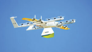
Wing and Apian have partnered with Blackrock Health and St. Vincent’s Private Hospital in Dublin, Ireland, along with healthcare technology company Medtronic, to launch a UAV delivery trial for medical supplies and devices. The delivery service will include Medtronic’s ingestible camera, PillCam, sutures, surgical tools and heart valve repair products, with plans to expand to pacemakers and implantable cardiac defibrillators (ICDs) in the future. Wing’s UAVs are designed for quicker and more reliable deliveries than traditional transport methods, avoiding traffic congestion in Dublin.
Finland faces increase in GPS jamming
Finnish authorities have reported a surge of GPS malfunctions in the area. Authorities speculate the disturbances are due to Russian jamming. The reports were brought to the public’s attention when a Finnish maritime pilot shared on social media a video depicting radar malfunctions. Traficom, Finland’s federal transport and communications agency, told local news outlet Iltalehti that there has been a noticeable increase in GPS malfunctions, although it detected no interference with radar frequencies in the Gulf of Finland.
Scientists from the Beijing Institute of Spacecraft System Engineering proposed the construction of 21 positioning, navigation and timing (PNT) satellites around the moon to support China’s lunar ambitions. The satellites will be deployed in four types of orbits over three phases, featuring a sustainable and cost-effective design, according to a paper published in the Chinese Space Science and Technology journal. China aims to put astronauts on the moon by 2030 and build a research base at the lunar south pole with international partners around 2035, according to the paper.
Institute of Navigation (ION) GNSS+ is the world’s largest technical meeting and showcase of GNSS technology, products and services. This year’s conference will bring together international leaders in GNSS and related positioning, navigation and timing (PNT) fields to present new research, introduce new technologies, discuss current policy, demonstrate products and exchange ideas.
This year’s conference, scheduled for Sept. 16-20, 2024, at the Hilton Baltimore Inner Harbor in Baltimore, will bring together international experts in GNSS and related positioning, navigation, and timing (PNT) fields to share research, unveil new technologies and engage in critical policy discussions.
The conference will feature more than 300 technical presentations across six sectors, covering commercial and policy aspects as well as research advancements. Attendees can also attend insightful keynote speeches, including a presentation by Oscar Pozzobon, Ph.D., from Qascom, on pushing the limits of satellite navigation systems for lunar exploration.
The exhibit hall will be open on Sept. 18 -19, showcasing the latest GNSS technology, products and services. Attendees will have the opportunity to explore and engage with industry-leading innovations.
GPS World, a proud media partner of ION GNSS+ 2024, will attend the conference and be located at booth 215, next to Syntony GNSS and Iridium.
Click here to view the full ION GNSS+ Technical Program.
Carnegie Robotics, an advanced robotics systems and sensors company, has acquired Swift Navigation’s Duro product line. The acquisition expands Carnegie Robotics’ IP portfolio of smart machinery across industries such as rail, intermodal, agriculture, construction, mining, marine, and more.
Launched in 2017 through a collaboration between Swift Navigation and Carnegie Robotics, the Duro product line features high-precision GNSS receivers and software designed to deliver reliable centimeter-accurate positioning in challenging environments. Since the launch, Carnegie Robotics and Swift Navigation have worked together to respond to users’ needs.
The acquisition also supports Swift Navigation’s shift to a software-only service model with hardware integrations. Duro integrates with Swift’s Skylark Precise Positioning Service, a cloud-based GNSS corrections service designed to provide high-accuracy positioning for various applications.


 Finnish authorities have reported a surge of GPS malfunctions in the area. Authorities speculate the disturbances are due to Russian jamming. The reports were brought to the public’s attention when a Finnish maritime pilot shared on social media a video depicting radar malfunctions. Traficom, Finland’s federal transport and communications agency, told local news outlet Iltalehti that there has been a noticeable increase in GPS malfunctions, although it detected no interference with radar frequencies in the Gulf of Finland.