Author: Jesse Khalil

  • Seen & Heard: Landslides, surveillance risks, 911 calls

    Seen & Heard: Landslides, surveillance risks, 911 calls

    “Seen & Heard” is a monthly feature of GPS World magazine, traveling the world to capture interesting and unusual news stories involving the GNSS/PNT industry.


    Surveillance risk in Apple products

    Photo: MStudioImages / E+ / Getty Images
    Photo: MStudioImages / E+ / Getty Images

    A recent study published by the University of Maryland revealed a major privacy vulnerability in Apple’s Wi-Fi Positioning System (WPS). Hackers can track Wi-Fi access points and their users globally. Apple’s WPS relies on the company’s vast network of iPhones, iPads and MacBooks to collect the geolocation of Wi-Fi access points based on their Basic Service Set Identifier (BSSID). When an Apple device uses GPS, it reports the coordinates of nearby Wi-Fi BSSIDs to Apple’s servers, allowing other Apple devices to estimate their location even without GPS. Hackers can access these points and access unsuspecting users’ locations.

    UAVS for 911 calls

    Photo: aerogondo / iStock / Getty Images Plus / Getty Images
    Photo: aerogondo / iStock / Getty Images Plus / Getty Images

    The New York City Police Department (NYPD) will soon improve its crime-fighting efforts with the Drone as First Responder (DFR) pilot program. The program will deploy UAVs in response to specific 911 calls for serious crimes in progress, such as shootings, robberies and missing persons. UAVs will launch from five precincts: the 48th Precinct in the Bronx, the 67th, 71st and 75th Precincts in Brooklyn and Central Park, New York. The UAVs will provide real-time video and telemetry to officers to enhance situational awareness and safety.

    Geospatial data offered in Africa

    Photo: Stanislav Gvozd / iStock / Getty Images Plus / Getty Images
    Photo: Stanislav Gvozd / iStock / Getty Images Plus / Getty Images

    AfriGIS, a geospatial solutions company, offers verified and validated geospatial data on administrative boundaries linked to postal codes throughout Africa. Expanding the company’s geospatial datasets to cover the continent, AfriGIS has developed a collection of shapes defined by closed lines that represent geographical areas — called a polygon dataset — for 21,600 towns, including 475,000 suburbs, over the past three years.

    Landslide in Papua New Guinea

    Photo: Maxar Technologies/Reuters
    Photo: Maxar Technologies/Reuters

    Maxar Technologies has released satellite images revealing the large scale of damage from the May 24 landslide in Papua New Guinea. The images show a significant portion of the mountainous Enga Province being torn away, with as many as 2,000 people believed to be buried under rubble. Satellite imagery from before and after the landslide illustrates the vast impact on the landscape.

  • Leica Geosystems advances utility detection

    Leica Geosystems advances utility detection

    Leica Geosystems, part of Hexagon, has launched the Leica DD300 CONNECT utility locator and Leica DA300 signal transmitter, a combined, ready-to-use solution for versatile utility detection.

    The solution aims to enable professionals to make accurate, in-depth underground investigations and obtain on-the-spot insights regarding the underground network.

    Users new to surveying can access video tutorials on the LCD for a step-by-step approach to surveys. Meanwhile, expert users can access a comprehensive range of advanced features. For example, the digital trim allows manual management of the gain bar to adjust the device’s sensitivity. It also offers a wider range of acquisition frequencies between 33 kHz and 131 kHz, including a unique 83 kHz frequency which is ideal for long-distance tracing.

    The new utility locator seamlessly integrates with the Leica DX Shield software, providing easy-to-use tracking tools and a centralized hub for managing on-site activities and multiple devices. Operators can also connect the hardware to the DX Field Shield app, enabling real-time remote data transfer of cable locator information directly to the office. Additionally, the USB connection offers convenient data download, analysis and product maintenance with self-calibration functionalities through DX Shield Office software.

    Detecting the position of underground utility networks is key to increasing worker safety and avoiding damage to underground infrastructures. The new Leica DD300 CONNECT is designed to improve safety and mitigate personnel and property damage risks.

    The Leica DD300 CONNECT and DA300 Transmitter. (Photo: Leica Geosystems)
    The Leica DD300 CONNECT and DA300 Transmitter. (Photo: Leica Geosystems)
  • u-blox module receives OSNMA firmware update

    u-blox module receives OSNMA firmware update


    ZED-F9P.png 
    Image: u-blox

    u-blox has released the first firmware update of its ZED-F9P GNSS module to support Galileo Open Service Navigation Message Authentication (OSNMA).

    The upgrade enhances the multi-band GNSS module’s spoofing and jamming detection capabilities, offering robust and reliable performance for various applications, such as robotic lawnmowers, UAVs and surveying and mapping.

    The module also features improved real-time kinematic (RTK) convergence to reduce the risk of incorrect readings, which are important to surveying-related applications.

    According to u-blox, the SPARTN Beidou satellite constellation support boosts the capabilities of GNSS receivers and enhances the performance of the u-blox PointPerfect GNSS correction service in certain regions. The receivers are equipped with an advanced ionospheric model for more reliable performance during elevated ionospheric activities.

  • Launchpad: Tactical-grade IMUs, Spirent simulator upgrades, atomic clocks and more

    Launchpad: Tactical-grade IMUs, Spirent simulator upgrades, atomic clocks and more

    A roundup of recent products in the GNSS and inertial positioning industry from the July 2024 issue of GPS World magazine.


    MAPPING

    Photo:

    Mobile Mapping System
    With integrated inertial labs INS/lidar

    The Meridian mobile mapping system integrates the Mosaic X camera with Inertial Labs inertial navigation system (INS) and lidar to improve mapping accuracy.

    The Meridian system offers panoramas with a 74 MP native resolution and 13.5 K resolution using precisely synchronized camera modules. The design minimizes image overlap to offer clearer and more consistent panoramas. The integrated INS system has a vertical accuracy of 2 cm to 3 cm and a precision of 2 cm to 4 cm.

    It features seamless, out-of-the-box operations with fully integrated and calibrated components. The Meridian system is designed for ease of use and requires only minutes of training. In addition, it features a rugged design to ensure performance in challenging environments.

    Mosaic, mosaic51.com


    OEM

    Photo:

    INS
    Combines a GPS master clock with an INS

    The Geo-APNT serves applications requiring precise navigation data and an accurate time reference. The Geo-APNT combines a versatile GPS master clock with an INS to
    offer assured positioning, navigation and timing (PNT) under all circumstances, including temporary loss of GPS signal. It minimizes size, weight and power (SWaP) due to the integration of positioning and timing that are typically achieved by two independent subsystems.

    It can be easily integrated into existing systems and supports RTK and PPK positioning and offers support for MEMS, fiber optic gyro and ring laser gyro inertial measurement units (IMUs). The system also includes GPS antenna and cables.

    AEVEX Aerospace, aevex.com

    Photo:

    Tactical-Grade IMUs

    For unmanned applications

    This line of tactical-grade IMUs is engineered to address the evolving needs of unmanned applications and 2 space-based operations.

    The IMUs include Iconyx, a high-performance HRG-based IMU that significantly outperforms legacy technologies, the company says. It offers improved accuracy and reliability for demanding navigation needs. It also features a small tactical IMU (STIM) ideal for applications requiring lower size, weight and power (SWaP).

    The company is upgrading its Geonyx inertial navigation system (INS), which is based on HRG technology, to incorporate M-Code capability. The fully integrated solution can perform in GPS- denied or spoofing environments, offering reliable navigation in challenging environments.

    Safran Federal Systems, safranfederalsystems.com

    Photo:

    GPS-Aided INS
    For land, marine and aerial applications

    The INS-FI, a GPS-INS, is designed for enhanced performance and reliability across various platforms including land, marine and aerial applications.

    The INS-FI is built with tactical-grade fiber optic gyroscope (FOG) technology and an IP67 rating, indicating its robustness and resistance to electromagnetic and environmental interference. This system integrates an IMU that combines fiber optic gyroscopes and MEMS accelerometers, along with an all-constellations GNSS receiver supporting multiple bands.

    It offers horizontal and vertical positioning with approximately 0.1% error of distance traveled for land applications and a drift of five nautical miles per hour for aerospace applications without GNSS signal. INS-FI is fully compatible with Inertial Labs’ Air Data Computer (ADC), visual inertial navigation systems (VINS) and a stand-alone magnetic compass (SAMC).

    INS-FI incorporates sensor fusion filter technology, navigation and guidance algorithms and calibration software to ensure optimal performance and reliability. The system aims to provide precise horizontal and vertical positions, velocity, and absolute orientation (heading, pitch and roll) for any mounted device, maintaining high accuracy for both stationary and dynamic applications.

    Inertial Labs, inertiallabs.com


    TRANSPORTATION

    Photo:

    GNSS Receiver

    Rated IP67 for water and dust resistance

    The M100X GNSS receiver is built with the Quantum-III SoC Chip, designed to provide full-constellation and multi-frequency capabilities, specifically engineered for high-accuracy vehicular positioning and heading.

    The M100X features GNSS/INS integrated technology to provide real-time high- precision positioning, velocity and heading data, even in challenging environments.

    The receiver provides accurate positioning and heading information across various applications, including autonomous mining trucks, intelligent ports, mapping and autonomous buses. It is designed to safeguard vehicles as they pass through areas with poor signal reception, even in obstructed environments such as urban canyons, city overpasses, underground garages, tunnels and parks.

    The M100X has a data update rate of up to 100Hz, allowing it to perform well in
    very dynamic environments, such as vehicles traveling at high speeds. This rapid update capability enables continuous and real-time tracking of vehicle positions for reliable computation and instant updating of navigation information. It also facilitates quick responses to changes in vehicle dynamics during travel. These features are essential for maintaining seamless operation in high- speed environments and ensuring high levels of safety and performance.

    Constructed with aluminum alloy and rated IP67 for water and dust resistance, the receiver is built to withstand harsh operational environments. It also features a shock-resistant design, capable of surviving a drop from 1 m without damage. It can connect to 4G, LAN, Bluetooth and multiple I/O ports for seamless integration with various systems and networks.
    The M100X can be used with the Navigation Master software, an Android app for quick device configuration and effective remote management. Using Bluetooth connectivity, users can configure their M100X devices for optimal performance. Additionally, its cloud platform, NaviCloud, offers instant access to projects and data from any location.

    ComNav Technology, comnavtech.com


    SIMULATORS

    Photo:

    Spirent Simulator Upgrades

    Now implementing PULSAR

    Spirent has implemented Xona Space Systems’ PULSAR production signals for seamless integration into the existing SimXona product line. The PULSAR X1 production signal implementation has passed Xona certification and the PULSAR X5 signal verification process is currently underway. It is expected to pass certification during the summer of 2024. Spirent is now accepting orders for SimXona with production signals capability.

    Xona is developing PULSAR, a high-performance PNT service built on a backbone of low-Earth orbit (LEO) small satellites. Xona’s smallsat signals will improve PNT resilience and accuracy by augmenting GNSS while operating with an independent navigation and timing system architecture. Xona is fully funded to launch its production class satellite, the In-Orbit Validation mission, in 2025.

    Spirent is the leading provider of PNT test solutions and recently launched a sixth-generation simulation system, PNT X. Designed for navigation warfare (NAVWAR) testing, PNT X is an all-in-one solution with native implementation of SimXona.

    Spirent, spirent.com

    Photo:

    GNSS Simulator 

    Compatible with Satgen simulation software

    The LabSat 4 GNSS simulator is designed to meet the demands of modern GNSS signal testing. It is equipped with three radio frequency channels, each of which can be configured with up to 12-bit I&Q quantization and a bandwidth of up to 60 MHz. This allows users to precisely control recording parameters and optimize file sizes based on their specific testing requirements. Additionally, synchronized record and replay of external data sources such as CAN, CAN-FD, RS232 and digital event capture are designed to further enhance complex test scenarios.

    Users can save custom record settings for efficient setup and repeatability. Additionally, a user-friendly, web-based interface allows for easy configuration and management of the simulation environment.

    LabSat 4 offers file management capabilities with 7.6 TB internal storage and robust data transfer options via Gigabit Ethernet and USB 3.0. This technology accommodates the high- volume data needs of modern GNSS testing without sacrificing speed or performance.

    It is small, portable and cost-effective, making it suitable for use both in the field and in the laboratory. LabSat 4 is fully compatible with SatGen Simulation Software, which allows users to create GNSS RF I&Q scenario files based on custom trajectories. This integration enables the simulation of scenarios involving multi-stop routes, time zone transitions, leap seconds and more, using any specified time, date and location.

    LabSat, labsat.co.uk

    Photo:

    Warfare Simulator

    Tests military receivers

    BroadSim Duo is a dual-frequency GNSS simulator designed specifically for testing military receivers in an unclassified environment.

    BriadSim Duo integrates dual-frequency capabilities within a single compact GPS military signal testing unit. The simulator has dual-frequency capability, which is essential for testing P-Code and AES-M-Code. It features a new software-defined radio in an M.2 form factor, offering robust and reliable performance. It also seamlessly integrates with the Skydel simulation environment for improved versatility and functionality.

    Safran Federal Systems, safranfederalsystems.com


    TIMING

    Photo:

    Atomic Clocks

    For PNT services

    Adtran has released two optical cesium atomic clocks, the OSA 3300 Super High-Performance (OSA 3300 SHP) and the OSA 3350 Super Enhanced Primary Reference Clock+ (OSA 3350 SePRC+). The devices use optical pumping technology to meet evolving demands across applications from scientific research to critical PNT infrastructure.

    The OSA 3300 SHP offers stability and accuracy, making it a valuable tool for metrology institutes and scientific research facilities. The OSA 3350 SePRC+ is specifically designed to enhance holdover capabilities for PNT services.

    It maintains 100 days of 100-nanosecond precision, providing continuous and accurate timing even in environments where GNSS is compromised or unavailable. This makes it a crucial

    component for ensuring the integrity of mission-critical networks and supporting vital infrastructure and defense operations with reliable backup timing.

    Adtran, adtran.com


    MOBILE

    Photo:

    Smart Atenna

    For surveyors and construction professionals

    The Zenith60 Pro GNSS smart antenna is designed for surveyors and construction professionals. It is a real-time kinematics (RTK) rover that features calibrated free tilt compensation to measure otherwise inaccessible points. The antenna is suited for harsh climates, urban areas, dense canopy coverage or other challenging terrains.

    This multi-constellation, multi-frequency GNSS receiver features a GNSS board with more than 800 channels and IP68 protection against dust and water. It also connects with GeoMax total stations and X-PAD field software to create an efficient and flexible workflow.

    GeoMax Positioning, geomax-positioning.com

    Photo:

    Helical Atenna

    House or embedded

    The HC979XF antenna is designed to provide optimal support for the entire GNSS band, including GPS/QZSS L1/L2/L5 (QZSS L6), GLONASS G1/G2/G3, Galileo E1/E5a/b/E6, BeiDou B1/B2a/b/B3, NavIC L5 and L-Band corrections services.

    The key new feature of the HC979XF and HC979EXF antennas is the support for Galileo’s Global High Accuracy Service (HAS) and QZSS’s regional Centimeter Level Augmentation Service (CLAS). Both correction services are broadcast in the E6/L6 band (1258- 1300 MHz).
    The radio frequency spectrum has become congested worldwide due to the activation of many new LTE bands. Their signals or harmonic frequencies can affect GNSS antennas and receivers.

    In North America, the planned Ligado service, which will broadcast in the frequency range of 1526 to 1536 MHz, can affect GNSS antennas that receive space-based L-band correction service signals (1539 – 1559 MHz). New LTE signals in Europe [Band 32 (1452 – 1496 MHz)] and Japan [Bands 11 and 21 (1476 – 1511 MHz)] have also affected GNSS signals. Calian’s XF models are designed to mitigate the effects of these new signals.

    The Calian HC979XF housed helical antenna weighs 42 g and is enclosed in a military-grade IP69K plastic enclosure. The embedded HC979EXF helical antenna weighs 8 g. It is easily mounted with an optional embedded helical mounting ring, which traps the outer edge of the antenna circuit board to the host circuit board or any flat surface. An MCX connector is installed in the base of the antenna.

    Calian, calian.com


    UAV

    Photo:

    Mapping software

    Designed for UAVS

    WingtraCLOUD software is designed to simplify data collection and streamline the onboarding of surveyors and pilots.

    WingtraCLOUD offers a user-friendly flight planning experience, plus time-saving features including site-based file organization, advanced 3D planning, coordinate system by sites and improved connectivity via cloud syncing in a single environment.
    It aims to simplify and streamline site setup and team collaboration. WingtraCLOUD’s features accelerate planning and introduce anew level of transparency among stakeholders with enhanced wireless functionality. Users can now provide insights to regional and global site managers across projects.

    WingtraCLOUD allows users to maximize Wingtra aerial data and services, offering UAV program scaling and business advantages across a variety of industries.

    Wingtra, wingtra.com

    Photo:

    AI Computer

    For unmanned systems

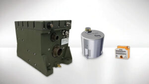
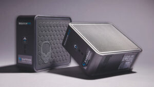
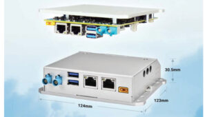
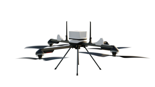
    FLYC-300 is designed 2 for advanced applications in UAVs, unmanned ground vehicles (UGVs) and autonomous mobile robots. Weighing 297 g, the FLYC-300 features a low size,
    weight and power (SWaP) form factor and delivers 100 TOPS AI performance. It supports autonomous navigation, object detection, real-time inference, and SLAM capabilities.

    The FLYC-300 is suitable for industries such as inspection, logistics, rescue operations, security, agriculture and environmental monitoring. It supports a variety of sensors and cameras, accommodating RGB, infrared, hyperspectral, HDR and high-resolution cameras. It can seamlessly integrate with flight controllers, vehicles or robots.

    The computer can operate with a wide voltage input range from 4S to 14S battery packs or 12 V to 60 V DC input via the XT30 DC-IN connector, making it versatile for different unmanned systems. It also supports 5G or 4G modules for real-time transmission of images, videos and data. The computer is available in two configurations, with or without an enclosure, to meet varying application needs.

    Neousys Technology, neousys-tech.com
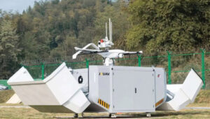
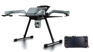
    Photo:

    VOTL UAV

    ‘Drone-in-a-box” solution

    The VTOL hangar drone combines the JOUAV JOS-C800 hangar with its new VTOL fixed-wing UAV, CW-15V.

    This “drone-in-a-box” solution isdesigned to offer amore efficient and versatile solution for businesses looking to optimize their routine operations through automated aerial technology.

    The JOS-C800 hangar system is composed of an automated hangar, a newly developed VTOL fixed-wing drone CW-15V, and the Jocloud management platform. This system enables complete management and monitoring of automated aerial missions through cloud-based remote operations.

    Its key features include autonomous takeoff and landing, intelligent flight planning, automatic charging, data management, intelligent data analysis and report generation, enabling fully automated drone operations without the need for on-site personnel.

    The JOS-C800 uses AI and AR algorithm integration to classify and identify potential hazards in the collected data, supporting the display and management of these hazards on Jocloud, and generating detailed hazard classification reports. The upgraded algorithms allow for real-time stitching and comparison of video data comparative analysis to identify new or changed hazards.

    It supports multi-UAV, multi-hangar operations with staggered takeoffs, allowing for hop-and-fly operations. The CW-15V UAVs can be paired with various payloads such as gimbal cameras, lidar and oblique cameras.

    JOUAV, jouav.com

    Air Traffic Surveillance Solution

    Supports BVOLS UAV operations

    INVOLI, a specialist in cooperative air traffic surveillance solutions, has partnered with MatrixSpace to create a comprehensive air traffic awareness solution through a unified platform.

    The partnership combines INVOLI’s cooperative detection technology with MatrixSpace’s advanced non-cooperative detection capabilities, facilitated by miniaturized primary radar technology. This integration allows for complete surveillance of both airborne and ground-based traffic, significantly enhancing UAV detection, counter unmanned aircraft system (CUAS) capabilities and safety for beyond visual line of sight (BVLOS) operations.

    The integrated solution is designed to be low in size, weight, power and cost (SWaP-C), and can be deployed quickly without the need for additional infrastructure or specialist training. This makes it suitable for a variety of applications, including surveillance of sensitive sites such as prisons and energy infrastructure, as well as supporting safe and efficient BVLOS UAV operations.

    INVOLI, involi.com


    DEFENSE

    Photo:

    Anti-Jamming Receiver

    Meets tight SWaP-C requirements

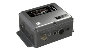
    NavStorm-M is a gun-hardened integrated anti-jamming GPS receiver for artillery, bombs, missiles and unmanned systems.

    It features a layered protection approach using beamforming, anti-spoofing, resiliency and software assurance. It is an assured positioning, navigation and timing (A-PNT) device featuring M-Code GPS technology. It offers GNSS protection of two bands (L1/E1+L2 or L1 + G1 or L1/E1 + L5) from up to three directions of jamming simultaneously.

    NavStorm-M is designed to meet the tight size, weight, power and cost (SWaP-C) requirements of unmanned aircraft systems, loitering munitions, hypersonic platforms and other weapons — especially in gun-hardened applications. NavStorm-M offers precise GPS navigation as a stand-alone system or integrated with an INS.

    BAE Systems, baesystems.com
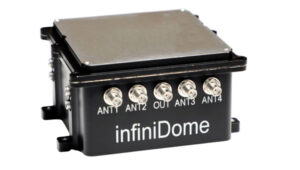
    Photo:

    GNSS Receiver

    For manned and unmanned group vehicles 

    GPSdome2 is a high-end anti-jamming and fully retrofit solution tailored for defending manned and unmanned ground vehicles and UAVs from jamming attacks. It can be integrated with various GNSS off-the-shelf receivers. Using up to four off-the-shelf active antennas, with dual-band protection — GPS L1+L2 or GPS L1+Glonass G1 — it protects from up to three jamming directions simultaneously in each band. With optional mil-spec compliance, it can serve smaller and lighter platforms.

    infiniDome, infinidome.com

    Photo:

    Loitering Munition

    For air, land and sea

    Atlas is a Group II loitering munition with robust capabilities in air, land and sea tactical scenarios. With a flight duration of more than two hours and a striking distance comparable to larger Group III aircraft, Atlas delivers mission flexibility and performance.

    Designed for high-impact scenarios, it supports a range of operations such as intelligence, surveillance, and reconnaissance (ISR)/detect, identify, locate and report (DILR), electronic warfare and direct-action engagements. The munition’s payload includes options for fragmentation or penetration effects, further enhanced by optional ISR capabilities.

    AEVEX Aerospace, aevex.com

    Photo:

    Portable UAV 

    Serves ISR applications

    Zoe M4 is a portable and foldable quadcopter platform designed to rapidly deploy an overwatch capability for military personnel and units. It is easy to transport and set up, making it ideal for security, ISR (intelligence, surveillance, and reconnaissance), and emergency response applications.

    It is equipped with the NextVision Raptor X80, a military-grade EO/IR gimbal that offers stabilized daytime and night-time imagery with 80x zoom and thermal imaging in high resolution. The NDAA-compliant quadcopter features the same rugged capabilities as the base Acecore Zoe model, including a robust carbon fiber construction, an all-weather waterproof design and the ability to survive winds of up to 29 knots.

    The Zoe M4 is paired with Acecore’s Signav Ultra ground control station (GCS), a lightweight handheld device based upon the Panasonic FZ-M1 tablet and rated to MIL-STD-810G. It can be factory-configured for compatibility with existing military networks or frequency bands between 1625 to 2510 MHz.

    Acecore, acecoretechnologies.com

  • Aptella, Sphere Drones advance autonomous scanning and mapping

    Aptella, Sphere Drones advance autonomous scanning and mapping


    Photo: Sphere Drones
    Photo: Sphere Drones

    Aptella has partnered with Sphere Drones, an Australian-based full-stack technology and UAV provider, for Aptella to distribute the Sphere Drone HubX mobile payload platform. The platform supports autonomous scanning and mapping operations for users across the resources, mining, construction and emergency services sectors. 

    HubX is a mobile solution designed for drone-in-a-box (DiaB) or terrestrial scanning tasks in regional and hard-to-access locations. Its self-sustained, mobile form factor makes it readily deployable on any site. Its bespoke solar power system and the 5G/satellite internet solutions are backed by built-in redundancies. 

    The HubX platform offers a versatile and large configurable payload bay, allowing users to mix and match enterprise payloads to meet their specific needs and enhance remote data collection. This includes seamlessly integrated DiaB and terrestrial scanner payloads, as well as the ability to plug and play any third-party payload hardware.  

    When paired with DJI’s Dock 2, HubX simplifies DiaB operations, enabling businesses to be operational on the day of delivery and have pilots ready to fly within 30 minutes of arrival. This setup accelerates the adoption of UAV operations and facilitates the transition to beyond visual line of sight (BVLOS) operations. 

    Obtaining certification to operate UAVs via a remote operations center (ReOC) is typically a complex and time-consuming process. However, the HubX solution streamlines this with a managed service offering, the company said. 

    Aptella, with locations across all states and territories of Australia, Southeast Asia and New Zealand, supports the civil construction, building, mining and geospatial industries. Under the agreement, Aptella will provide HubX demonstrations and initial deployments, working in collaboration with Sphere Drones for technical support. 

  • How NOAA is digitizing charts of the Erie Canal

    How NOAA is digitizing charts of the Erie Canal

    Built between 1817 and 1825, the Erie Canal provided a water route from Albany to Buffalo, New York, nearly 363 miles to the west. The Canal connected the Hudson River with the Great Lakes via parts of the Mohawk River, through various land cuts and natural lakes.

    Photo: NOAA
    Photo: NOAA

    Today, NOAA cartographers from the Marine Chart Division are converting paper nautical charts to a digital format and incorporating them into NOAA electronic navigational charts (NOAA ENC). NOAA created its suite of ENCs by digitizing its paper nautical charts. An ENC is a vector database that supports all types of marine navigation. Marine navigators can use the system to see their real- time position in relation to features on a chart.

    Marine navigators using NOAA ENC. (Photo: NOAA)
    Marine navigators using NOAA ENC. (Photo: NOAA)

    By digitizing the paper Erie Canal charts, NOAA can now provide ENCs for the canal from Albany to Lake Ontario. As part of the digitizing process, NOAA cartographers standardized the chart scales covering the canal, moving away from the 64 irregularly shaped paper charts in chart 14786, New York State Canal System.

    1:10,000 SCALE NOAA Custom Chart output near Waterford, New York.(Photo: USGS/NOAA)
    1:10,000 SCALE NOAA Custom Chart output near Waterford, New York. (Photo: USGS/NOAA)

    The ENC is the primary nautical navigation product of the agency, which is ending the production and maintenance of its traditional paper and raster nautical chart products. The remaining paper charts are only being updated with critical corrections until they are fully canceled. Chart 14786 will be one of the last ones canceled, on Dec. 5, 2024.

    Now, marine users are referred to the NOAA Custom Chart Application. It is an online map tool for users to create paper and PDF nautical charts derived from the official NOAA ENC.

  • uAvionix, Volant Autonomy advance air traffic management system

    uAvionix, Volant Autonomy advance air traffic management system

    Photo: uAvionix\
    Photo: uAvionix

    uAvionix has integrated its FlightLine surveillance services with Volant Autonomy’s integrated traffic management (ITM) system for Agile and Integrated Airspace System (ALIAS), a UK Government Future Flight Phase III project.

    The collaboration, showcased in the Channel Islands and New Jersey Airport, aims to advance the integration of unsegregated crewed and uncrewed operations into the UK airspace system and support beyond visual line of sight (BVLOS) operations for uncrewed aerial systems (UAS).

    Following the completion of Project ALIAS in June 2024, Volant Autonomy has seen a surge in interest in its BVLOS-enabling technology. uAvionix’s FlightLine system proved to be an asset in supporting the consortium’s demonstration flights, according to Anthony Lawrenson, COO of Volant Autonomy.

    The integration delivers timely and reliable automatic dependent surveillance-broadcast (ADS-B) positional data, which forms an important part of the ALIAS traffic information service (TIS). It is crucial to obtain and use accurate positional data joint with primary and secondary radar feeds from ports of Jersey (ATC) to operate Volant’s DAA solution. This solution complies with the RTCA’s ACAS sXu (Aircraft Collision Avoidance System) standards.

    During the latest ALIAS trials, the Diamond DA-42 aircraft operated by Draken provided safe and dynamic separation from UAVs operated by SkyLift and SkyPorts. The trials also showcased SkyLift’s unmanned aircraft operating in and out of test sites, demonstrating the realistic potential for multiple airborne services to operate safely within a live Air Traffic Control (ATC) environment.

  • oneNav’s L5-direct safeguards defense and location services

    oneNav’s L5-direct safeguards defense and location services

    Photo: oneNav
    Photo: oneNav

    oneNav has released the results of a test evaluating the resilience of its technology to widespread GPS interference. The testing was conducted in and around Haifa, Israel and focused on the performance of its L5-direct GPS receiver compared to GPS receivers in top smartphone and smartwatch brands.

    For this test, oneNav compared its L5-direct GPS receiver to receivers found in iPhone, Samsung Galaxy and Google Pixel smartphones and Garmin watches. While these receivers all experienced navigation failure due to GPS interference, oneNav’s L5-direct test solution maintained accurate location fixes despite active jamming and spoofing.

    This resilience is due to L5-direct’s ability to directly acquire L5 GPS signals and bypass the L1 GPS signal, which was first invented more than 50 years ago. While current commercial GPS receivers in smartphones, car navigation systems, and airplanes can process the L5 band, they can only do so in a hybrid system that must first acquire L1.

    According to the company, L5-band signals are 30 times harder to jam and interfere with than L1 and offer improved performance in difficult-to-navigate areas such as urban canyons and tree-covered regions.

    “We now have clear, indisputable evidence that L5-direct is resilient to widespread GPS jamming and can provide precision location in GPS-contested environments,” said, Steve Poizner oneNav CEO. “This test is a real-world validation of our first-of-its-kind technology and shows the potential for L5-direct to revolutionize how we use GPS for civilian and military purposes in Israel and globally.”

    While the field testing took place in Israel, GPS interference is a global security concern due to the increase in attacks on GPS systems worldwide. In Ukraine, Russia is countering American-made smart weapons on the battlefield through GPS-jamming technology and is accused of interfering with GPS navigation systems in more than 46,000 flights across Europe.

    oneNav’s IP core is available for evaluation and integration by select chip developer partners and its low-SWaP chips and modules will soon be available for select partners. L5-direct is compatible with all GNSS constellations.

  • US Army issues white paper request for CMFF prototypes

    US Army issues white paper request for CMFF prototypes

    Photo: U.S. Army
    Photo: U.S. Army

    The U.S. Army has released a Request for White Papers (RfWP) to develop new C5ISR modular open Suite of standards (CMOSS) mounted form factor (CMFF) prototypes.

    Through CMFF, the Army aims to easily and rapidly equip ground vehicles and aviation platforms with positioning, navigation and timing (PNT) and electronic warfare (EW), through capability cards plugged into a common chassis.

    The chassis, which offers power, networks and radio frequency, allows Soldiers to “plug and play” capabilities right into the vehicle without the need to custom install and upgrade individual communication and computing systems.

    In this prototype effort, the key needs are to develop, procure and furnish the Army with the CMFF chassis, also known as Mounted Common Infrastructure (MCI), plus the smart display for user interface, hardware development, software development and Plug-In Cards with the following capabilities:

    • Converging tactical communication waveforms.
    • Mission Command applications.
    • Assured Positioning, Navigation, and Timing (APNT.)
    • Force Protection capabilities.

    The Army plans to award a contract using the Other Transaction Authority (OTA) with system of system and prototype integrators to provide the complete CMFF system offerings. Industry partners who respond to the RfWP will have an opportunity to showcase the fully functional CMFF system at a technology demonstration in late summer 2024.

    “The power of the true concept is when you can take a chassis and put it in another vehicle and you can mix and match cards,” said Col. Shermoan Daiyaan, project manager for Mission Command. “That’s when you’re following a standard. You’re matching a standard, and it just works.”

  • Swift Navigation, Bad Elf enhance precision for construction and utilities

    Swift Navigation, Bad Elf enhance precision for construction and utilities

    Photo: Swift Navigation
    Photo: Swift Navigation

    Swift Navigation and Bad Elf have partnered to deliver a complete, turnkey solution for high-volume and high-precision GIS data collection. GIS data allows workers across industries to create precise digital maps to improve worker safety and efficiency in construction, utilities and environmental management.

    By combining BadElf’s GNSS receivers with Swift’s precise positioning solutions, field teams can capture centimeter-accurate location data on a tablet or smartphone Field teams can now more quickly and safely perform maintenance, dig trenches and avoid hazards such as high-voltage wires. wires.

    Swift’s Skylark Precise Positioning Service is a cloud-based GNSS corrections service that enables accurate and reliable positioning for location-based products worldwide. Skylark is offered in multiple variants for multiple use cases, each with varying requirements for accuracy, coverage, power consumption and cost.

    Bad Elf is a provider of GNSS receivers built for modern GIS mapping applications. Bad Elf’s line of Flex and Flex Mini receivers stream location data to any Bluetooth-equipped device, including Apple, Android, and Windows. When paired with Skylark, Bad Elf receivers deliver accuracy down to one centimeter and a fix within seconds. The combined solution is ideal for field workers requiring reliable high-accuracy positioning.

  • Trimble extends Esri partnership

    Trimble extends Esri partnership

    Photo: Thicha Satapitanon / iStock / Getty Images Plus / Getty Images
    Photo: Thicha Satapitanon / iStock / Getty Images Plus / Getty Images

    Trimble and Esri have extended their partnership to enhance collaboration in geographic information system (GIS) software, location intelligence and mapping. This ongoing effort aims to improve processes, support decision-making, and automate workflows for greener infrastructure planning, construction and operations for users.

    The companies are exploring emerging technologies, particularly in industry data models that support accurate generative AI technologies and workflows. Trimble’s geospatial field systems, which collect location intelligence and 3D datasets, are enhancing workflow support in Esri ArcGIS Indoors and the ArcGIS Utility Network.

    Trimble Unity — a new asset lifecycle management suite — leverages Esri’s GIS into construction project and capital planning, enterprise asset management and permitting solutions to improve how universities, healthcare facility operators, utilities and federal, state and local government jurisdictions track the asset management lifecycle.

    Trimble and Esri also partnered with The HALO Trust, the world’s largest landmine-clearing non-profit organization, which combined Trimble’s high-accuracy mapping technology with Esri’s ArcGIS software to improve the capacity to locate and remove landmines and other explosive hazards, making communities safer.

  • Inertial Labs, ideaForge integrate lidar solution into UAVs

    Inertial Labs, ideaForge integrate lidar solution into UAVs

    Photo: Inertial Labs
    Photo: Inertial Labs

    Inertial Labs has integrated its RESEPI lidar solution into ideaForge UAVs. The integration seeks to improve lidar mapping capabilities and is suitable for mining, forestry, geographic information system (GIS) and land surveys, water resources management and more.

    The UAVs equipped with RESEPI offer a vertical accuracy of 2 to 3 cm. The precision is maintained at 2 to 4 cm and it excels at a flight height of 50-100 m. The integration enhances the capabilities of ideaForge UAVs, offering users accurate and reliable data for mapping and surveying applications.