GPS vulnerabilities have been widely reported in the press. What steps have been taken to back up GPS use in U.S. critical infrastructure?
Jules McNeff
“President Biden on April 30 issued a National Security Memorandum on Critical Infrastructure Security and Resilience. GPS plays a vital role in the operation of critical infrastructure, and some sectors are considering their own backups. Other than conducting studies and meetings to admire the problem, the federal government has done virtually nothing to provide a comprehensive answer. In fact, the government is now dismantling the Loran system, though enhanced Loran (eLoran) is a viable and affordable GPS backup, specifically recommended for use by prior U.S. Department of Defense and U.S. Department of Homeland Security Deputy Secretaries. Given the vital role PNT and GPS play, it’s a mystery why such a viable solution is simply ignored.”
— Jules McNeff Overlook System Technologies
Will GPS remain the Gold Standard of space-based PNT services for the foreseeable future?
“GPS led the emergence and growth of a global space-based PNT service enterprise and has been the Gold Standard since its inception. The U.S. Department of Defense and Air Force (now Space Force) have maintained that standard through stable, transparent, and consistent policies and continuous performance improvements for the services it provides to all users. Now, in the face of foreign competition, hostile threats, budgetary pressures, reorganizations and management fragmentation, dilution of corporate memory, and inconsistent leadership support, those policy and performance foundations are in danger of eroding. The outcome for GPS and its future in the global PNT Enterprise is purely in the hands of our federal leadership today.”
The solar storm in May that produced a beautiful aurora borealis as far south as Mallorca, Spain, also stopped GNSS-based precision agriculture for a couple of days. The same month, articles in major U.S. newspapers detailed aspects of a growing confrontation between the United States, Russia and China —vying for dominance in near-Earth space, now part of the military fighting domain — that could lead to far greater disruption. Nearly all satellites are highly vulnerable to cyberattacks, ground- or space-based lasers, high-powered microwaves, the debris field from a destroyed satellite and the radiation produced by a nuclear explosion in space. The last one would disable by far the greatest number of satellites because of its range and because commercial satellites, which constitute more than 90 percent of all satellites in orbit, are not hardened against such radiation.
Luccio
A May 16 article in The Wall Street Journal titled “Russia Launched Research Spacecraft for Antisatellite Nuclear Weapon Two Years Ago, U.S. Officials Say,” reported that in February 2022, shortly before it invaded Ukraine, Russia launched Cosmos-2553, “designed to test components for a potential antisatellite weapon that would carry a nuclear device.” It linked the launch to a continuing Russian nuclear antisatellite program and said that, if deployed, the weapon “would give Moscow the ability to destroy hundreds of satellites in low-Earth orbit (LEO) with a nuclear blast.”
“The Pentagon,” the article pointed out, “has become increasingly reliant on commercial satellites.” In LEO, it reported, there are almost 6,700 U.S. satellites, while China has 780 and Russia only 149. Therefore, the Russians would have a lot less to lose should they choose to explode a nuclear weapon in LEO.
A May 17 article in The New York Times was titled “New Star Wars Plan: Pentagon Rushes to Counter Threats in Orbit.” The subhead read: “Citing rapid advances by China and Russia, the United States is building an extensive capacity to fight battles in space.” It said that, in a major shift in military operations, the Defense Department “is looking to acquire a new generation of ground- and space-based tools that will allow it to defend its satellite network from attack and, if necessary, to disrupt or disable enemy spacecraft in orbit.” Meanwhile, “both Russia and China have already tested or deployed systems such as ground-based high-energy lasers, antisatellite missiles or maneuverable satellites that could be used to disrupt [U.S.] space assets.”
The decision to strengthen U.S. warfighting capacity in space, it said, is driven mostly by China’s expanding fleet of military tools in space, which threatens to prevent U.S. Navy operations in the Western Pacific. “The Pentagon is separately working to launch a new generation of military satellites that can maneuver, be refueled while in space or have robotic arms that could reach out and grab — and potentially disrupt — an enemy satellite.”
These are all reasons to quickly develop and deploy a wide mix of complementary PNT solutions that would lessen reliance on GNSS satellites and, therefore, make them less of a target.
Wangjie Zhao, an employee of CHC Navigation. (Photo: CHC Navigation)
For decades, surveying — which consists largely of making measurements to determine the relative positions of points above, on or beneath Earth’s surface — had much higher accuracy than mapping for geographic information systems (GIS) — which is mostly based on aerial photogrammetry for base maps and field data collection of the locations of features. When I started in this field a quarter century ago, we typically classified GPS receivers as survey grade, resource grade or consumer grade, with “resource grade” referring to field data collection for GIS.
Today, however, the accuracy of all receivers has greatly increased — thanks to improved chipsets, new GNSS constellations, and a plethora of corrections services — and those three categories are no longer relevant. Therefore, surveying and mapping are increasingly overlapping.
For this cover story, I asked the same three questions about mapping and surveying to representatives of four companies.
CHC Navigation — Rachel Wang, product manager of survey and engineering product line
Hexagon — Craig Hill, VP marketing and services, surveying solutions, Leica Geosystems
Surveying and mapping are increasingly overlapping. What are the remaining differences between them, in terms of accuracy requirements and challenges in the field?
CHC Navigation
While advances in technology such as lidar and photogrammetry are narrowing the gap, there are still notable differences between surveying and mapping. Surveying often requires centimeter- or even millimeter-level accuracy at specific points. In contrast, mapping focuses on collecting dense 3D data over large areas. Although the accuracy of mapping point clouds is steadily increasing, the integration of ground-based GNSS data collection with aerial imagery and lidar is becoming widespread. Mapping tends to be less labor-intensive and involves fewer safety risks in the field, but it requires a unique skill set, particularly in point cloud processing.
Hexagon
Traditionally, surveying and mapping differ primarily in their accuracy requirements and application scales; however, this paradigm is changing with mapping becoming increasingly accurate. Surveying focuses on high-precision geospatial data of specific points. From road, rail and tunnel construction to high-rise buildings, there is no substitution for the precision delivered by surveying equipment and procedures. In contrast, mapping focuses on larger areas.
Recent advancements in sensor technology, including both airborne and mobile mapping systems such as the Leica CityMapper-2 and the Leica Pegasus TRK, have significantly improved the efficiency and precision of mapping, bringing it closer to the levels achievable with traditional surveying equipment.
OxTS
Surveying comes with a large overhead during the data collection process. It requires meticulous preparation and attention to detail to achieve high accuracy in the raw data. GNSS quality, lever arms, user operation, etc., can all cause problems later on. Getting any part of the process wrong can have major cost implications through having to redo the process.
Mapping is focused on the act of aligning that data to datums and control points after the surveying process is completed but it also requires major attention to detail in aligning coordinate frames and origin points in order to avoid baking in any errors that lead to mistakes being made once the map data is handed over to a customer
The problem is that if the surveying process wasn’t accurate, the mapping process will not have a solid foundation in the raw data to deliver accurate maps, so they are inherently tied to each other.
Trimble
Surveyors today have many tools in their toolbox, giving them flexibility across surveying and mapping applications. There are many highly accurate, easy-to-operate data capture systems to choose from these days, but challenges grow when combining and analyzing vast amounts of data from different sensors in the office to provide final deliverables. This has made field-to-finish software that delivers technological integration, workflow optimization and adaptability essential for the job.
Mapping projects often require less accuracy, but a lot of advanced survey technology is entering the mapping domain (e.g., mobile mapping and laser scanning) because of easier field operations and increasing understanding of the value of rich data to asset management.
The data were collected in and around a car park to prove how Lidar Inertial Odometry (LIO) can be used to retain accuracy for longer periods without GNSS updates. (Photo: OxTS)
What is your company’s niche in surveying/mapping?
CHC Navigation
CHC Navigation (CHCNAV) has been at the forefront of positioning and navigation for more than two decades, continually adapting to meet the diverse needs of the surveying and mapping industry. Our innovative solutions often lead the industry in providing end-to-end, integrated technology fusion — GNSS, inertial measurement unit (IMU) and imaging lidar — as a standard that empowers geospatial professionals worldwide. CHCNAV strives to provide accessible, value-added solutions from the start, positioning itself as a key technology enabler for the geospatial community.
Hexagon
Whether you are mapping an entire city or surveying a site for construction, capturing reliable and precise geospatial data is essential. Hexagon’s niche lies in its commitment to innovation, its extensive portfolio and the convergence of superior hardware, intelligent software solutions and expert services — enabling precise, efficient and scalable surveying and mapping for diverse needs. Our multitude of solutions, whether handheld, tripod-mounted, flying, or vehicle-mounted, are designed to collect data efficiently and safely from complex or dangerous environments — enabling the greatest accuracy and high-value deliverables.
Furthermore, Hexagon is uniquely positioned with its robust suite of software solutions that work seamlessly with our hardware, such as Reality Cloud Studio, Leica Cyclone, Leica Captivate or Leica Infinity for collecting, processing, modeling, analyzing, and presenting data. We offer end-to-end solutions that not only provide high accuracy but also ensure productivity and ease of use.
OxTS
OxTS offers localization and georeferencing technology that can help accelerate the collection of high accuracy survey data, allowing more work to be completed in a given time frame without compromising on accuracy.
Trimble
Trimble is known for offering a wide range of highly accurate and reliable data capture sensors but our “niche” — our truly unique offering — is our ability to offer comprehensive solutions that make our customers more productive and their projects more streamlined. We do this through hardware and software solutions that enable highly efficient survey and mapping workflows that connect field and office operations. Our software helps transform the captured data into true information utilizing an increasing number of AI-powered tools while our cloud services allow customers to share the data with a variety of stakeholders, unlocking the transformational power of geospatial data.
What is your latest surveying/mapping product? What are its key specs, markets and applications?
Hexagon
Among our surveying and mapping solutions, the Leica BLK ARC stands out with its flexibility to integrate with various robotic and mobile carriers. The BLK ARC provides autonomous laser scanning with static and dynamic scans, creating 3D digital twins and ensuring operator safety. Similarly, the Leica BLK2GO introduces an agile, handheld mobile scanning solution, capturing point clouds and images, with a user-friendly design. Both solutions are great allies for professionals requiring accurate, efficient, and versatile mobile scanning solutions.
For those looking to offer wide-scale data-capturing capabilities and overcome capacity constraints, the Leica Pegasus TRK mobile mapping system stands out because it can gather extensive data quickly and accurately. Its high-resolution data capture, advanced lidar technology, and enriched 3D point cloud capabilities ensure detailed and comprehensive datasets. Building on this range of solutions, the autonomous flying laser scanner Leica BLK2FLY enhances surveying efficiency by capturing hard-to-reach areas and environments. Its user-friendly operations, advanced obstacle avoidance and seamless cloud-based data integration make it a valuable tool for enhanced productivity and safety in surveying work.
CHC Navigation
Our latest offering, the RS10, demonstrates the integration of surveying and mapping technologies by combining GNSS RTK, laser scanning and visual SLAM into a unified platform. The RS10 enhances traditional GNSS capabilities with V-lidar and SFix technologies. V-lidar enables non-contact offset measurements up to 15 m, ideal for rover applications. Meanwhile, SFix technology leverages laser and visual SLAM data to deliver 5 cm accuracy within one minute in environments with weak or absent GNSS signals. This breakthrough enables accurate GNSS measurements in challenging environments such as indoor spaces and urban canyons, bringing simplified workflows and increased productivity to professional surveying and mapping.
OxTS
OxTS recently released Lidar Inertial Odometry (LIO), which offers improved localization in GNSS-obstructed environments while maintaining a fully global frame output. It means that survey data can retain accuracy for longer in harsher GNSS environments but doesn’t give up the global reference to coordinate frames used by surveyors and does not require ground control points to be anchored to those coordinate frames.
Trimble
The newly released Trimble Business Center (TBC) v2024.00 delivers on its commitment to innovation by offering technological integration and workflow optimization, as well as adaptability and innovation for the ultimate field-to-finish workflow. A key highlight in the new release is the seamless integration of survey data delivery for pavement inspection within AgileAssets, which bridges the gap between Esri and Autodesk through feature services for more efficient pavement management.
In addition, AI technologies provide enhanced point cloud classification and new feature extraction routines for game-changing analysis of aerial, terrestrial, mobile mapping and tunneling data. Collaboration also is greatly enhanced through Trimble Connect for seamless data integration across TBC and Trimble Access field software.
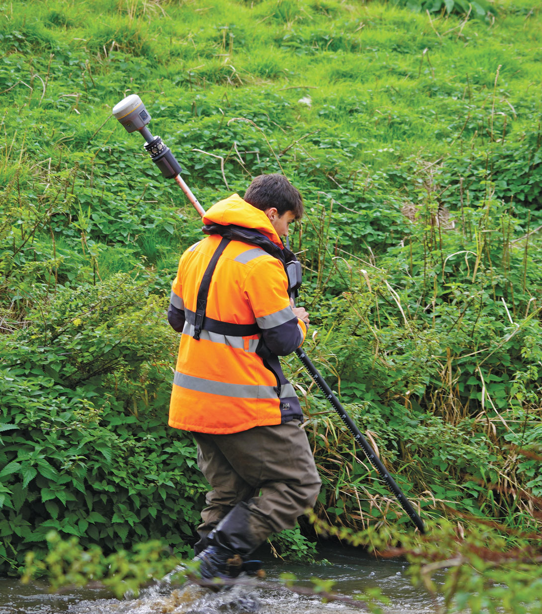
Josh Humphriss, surveyor at Storm Geomatics Limited, surveys a stream with a Trimble GNSS system in Shipston-on-Stour, Warwickshire, England in 2022. (Photo: Michael Dix, Marketing Communications Manager, Trimble, Inc.)
How can commercial space help bridge the GPS vulnerability gap by providing alternative PNT services?
“With the proliferation of commercial SATCOM services being launched to provide global broadband services, there is an opportunity to leverage these capabilities to also augment positioning, navigation and timing (PNT). The Defense Science Board has been directed to consider this and is evaluating how these commercial alternatives, such as PNT signals-as-a-service, could supplement GPS if technical and logistical challenges could be overcome.
With the recent announcement of Iridium buying out Satelles for $115M and the apparent interest in the U.S. Department of Defense (DOD) to consider using commercial alternatives to provide backup PNT, this is likely to spur other innovations in this space and bring more players (and investors) to the market. This has the potential to significantly increase PNT resilience around the world by enabling the use of existing SATCOM services, with a wide diversity of spectrum allocations separated from GPS, allowing operation
in a GPS-denied environment.
Deployment also can be accelerated by leveraging commercial manufacturers of SATCOM equipment who can rapidly release commercial products with alternative embedded PNT capability that can provide aiding data through the Modular Open Systems Approach (MOSA) standards already developed for A-PNT devices in the DOD acquisition process.
The major barrier to adoption of these services, however, could be the anemic funding being provided for adoption of commercial space services to Space Systems Command’s new Commercial Space Office (COMSO).”
This month’s cover story focuses on jamming and spoofing in the military domain, but this is also a big challenge for users of civilian GNSS applications, such as airline pilots. Our July cover story will focus on complementary PNT — that is, non-GNSS sources of positioning, navigation and timing data that can complement GNSS and help make up for its inherent shortcomings, such as weak signals that are easily blocked by thick foliage and roofs, multipath and few satellites in view from natural and urban canyons.
Matteo Luccio
In the coming months, we will steadily increase our coverage of complementary PNT companies, products and services, including those based on low Earth-orbiting (LEO) satellites, because they are an increasingly important component of the PNT industry. We will start by expanding our coverage of this area on our website and in our digital newsletters, then increase coverage in our print editions.
One proposal that has received scant attention, including from this magazine, is to set up a ground-based, cryptographically protected GPS High Accuracy and Robustness Service (HARS) using the internet to distribute data already being produced by the U.S. government and government-sponsored organizations. This was the subject of a white paper released in May 2023 by the National Space-Based Positioning, Navigation, and Timing Advisory Board.
The paper argued that GPS is “falling behind” other GNSS because it relies on augmentation by third-party systems rather than providing such specialized advanced services itself, as BeiDou and Galileo do. While nearly all GNSS chips currently acquire first GPS signals, then those from other systems, deployment by BeiDou and Galileo of sub-meter accuracy services may lead chip manufacturers to reverse this order. If they do, the paper argued, it will cause the U.S. government to lose its strategic advantage in this area and put it in the same position that led the Chinese and European governments to launch their own GNSS programs.
The paper proposed a HARS that would remove satellite orbit and clock errors, ionospheric errors, and tropospheric errors and enhance the ability of GNSS receivers to operate in challenging conditions. This approach, the paper says, could allow Precise Point Positioning (PPP), authentication, and more. It would be “secure and less sensitive to radio noise and disruptions,” protect critical infrastructure, and enable new applications, such as “lane-dependent route guidance in automobile navigation and emergency vehicle guidance.” Additionally, by delivering, along with the corrections, cryptographically signed ephemeris on the same channel, the system would solve the problem of spoofed navigation data.
All of this could be done “without adding cost and complexity to GPS itself” resulting in “a world-class HARS at a small fraction of the cost or time, compared to implementing it on new GPS satellites.” The paper asked for funding for this new service and an agency to operate it, such as the U.S. Space Force or the federal Department of Transportation.
I thank John Betz, Ph.D., of MITRE, for bringing the PNT Advisory Board’s white paper on HARS to my attention. It can be found here.
Jamming and spoofing continue to be the key challenges to military use of GNSS. While the production and adoption of M-Code receivers is delayed, defense contractors are developing several approaches to identify, locate and neutralize these threats — including CRPA antennas, embedded GPS inertial (EGI) navigators, software-defined radios and cryptography.
In this month’s cover story, executives from seven companies present their perspectives on the GNSS/PNT challenges faced by U.S. and allied military forces, their market niche in this area, and their latest products.
Lou Pelosi, vice president, CAST Navigation
Stig Pedersen, executive vice president of aerospace and defense, Autonomy & Positioning division, Hexagon
Brandon Malatest, COO, Per Vices Corporation
Tony Full, director of business development, Navigation Systems, Safran Federal Systems
Paul Crampton, senior solutions architect, Spirent Federal Systems
Joel Korsakissok, president, Syntony
Click here to read an exclusive interview with Chuck Stoffer, director of business development and Eric Hughes, design engineer, UHU Technologies
Read the related “Innovation” article.
Photo: Petty Officer 1st Class Thomas Gooley
What are currently the top two or three challenges regarding GNSS/PNT for U.S. and allied military forces? How do you expect that to change in the next three to five years?
CAST Navigation
A top challenge is anti-jamming. GPS signals are low-power and fairly easy to jam. CAST has developed a simulator for testing controlled reception pattern antennas (CRPAs), which are anti-jam antennas. CAST simulators can test CRPAs with two to seven antenna elements.
Another top challenge is preventing our enemies from using GPS in a war zone. M-Code Modernized Navstar Security Algorithm (MNSA) has been designed to support denial of GPS signals to enemy forces. CAST has developed the ability to simulate M-Code MNSA. The company is working closely with the U.S. Space Force Space Systems Command’s GPS Directorate to develop a simulator that supports all their requirements.
Hexagon
Jamming is the key challenge. The secondary challenge is getting necessary protection into fielded systems so they can be used to the full extent of their service life. Over the next three to five years, while new products designed to safeguard PNT infrastructure will emerge, the process of getting these tools authorized and integrated will remain complex.
Per Vices Corporation
GNSS signals can be disrupted or manipulated by adversaries through jamming techniques, leading to potential navigational errors or loss of positioning capabilities. Advanced spoofing techniques also pose significant challenges to GNSS/PNT for U.S. and allied military forces, as they can deceive receivers into providing inaccurate positioning, navigation, and timing information. Both can be addressed with the integration of software-defined radios (SDR) for GNSS/PNT applications where we anticipate a strong push to further advance the different anti-jamming and anti-spoofing techniques in software using high-performance SDR platforms.
Safran Federal Systems
GNSS denial and spoofing. Both challenges are expected to become more pervasive over the coming years as adversarial technologies evolve and are distributed. In the current conflict, systems are driving to become either assured GNSS or built to operate independently of GNSS clock and position information.
Spirent Federal Systems
Adversarial near-peer threats to PNT integrity are developing at an increasingly rapid pace. Navigation warfare (NAVWAR) used to focus within the boundaries of localized geopolitical conflicts, but now space-based, system-wide threats loom large and will present new challenges in the coming years. As PNT continues to evolve, more complex mitigation technologies must be integrated into a layered PNT ecosystem with shortened development and testing phases to be fielded faster.
Syntony
It is not a secret that jamming and spoofing will be the biggest challenges in the coming years: Almost every week, if not every day, we read some news about jammed or spoofed GNSS receivers, either in Eastern Europe or elsewhere.
Technology exists to protect against both threats: authentication, cryptography and CRPA. However, you cannot deliver an M-Code or PRS receiver to every soldier and every vehicle, if for no other reason than the difficulty of broadcasting the keys. The solution will pass by an intermediate level of anti-jamming and anti-spoofing receivers, which do not need them, associated to moderate prices and lighter infrastructure so that everybody and every vehicle can be protected.
For industry, it will pass through the generalization of CRPA architecture for the receivers, even for non-encrypted signals, and even with lower efficiency levels (update rate, J/S, etc.) corresponding to low dynamic movement.
What is your company’s niche regarding military GNSS/PNT?
senior software engineer Neil O’Brien utilizing a CAST-8000 GNSS simulator to analyze CRPA trajectory data. (Photo: CAST Navigation)
CAST Navigation
We are known for correctly interfacing with the military’s embedded GPS inertial (EGI) navigators.
Hexagon
We have carved out a distinctive position in the military APNT sector. We provide receivers that give users access to the entire GNSS spectrum, fortified by our unique GNSS Resilience and Integrity Technology (GRIT). Hexagon also produces anti-jam antennas designed to safeguard GNSS receivers, offering our customers tested protection in hostile environments.
Per Vices Corporation
We design, develop, and build high performance software-defined radio platforms and associated firmware/software for use in GNSS/PNT systems. This includes the use of SDRs for simulating hostile RF environments to test existing equipment, providing anti-jamming and anti-spoofing solutions, implementing dynamic frequency hopping, and signal authentication and integrity verification.
Safran Federal Systems
We are uniquely positioned to fulfill solutions to GNSS denial and spoofing through our precision timing, assured GNSS (M-Code/SAASM) and inertial navigation technologies. Additionally, we have these technologies often combined in different form factors to serve platform needs. When planning for missions, we offer our customers a full suite of mission simulation capabilities expediting the fielding of technologies by assuring functionality in a lab environment.
Spirent Federal Systems
We find our niche in partnering with industry and military institutions to provide innovative test solutions. Spirent NAVWAR test solutions enable PNT receivers to mitigate the effects of current and prospective threats. This involves new secure encrypted signals, space-based assets in a variety of orbital configurations, antenna and processing techniques, non-U.S. PNT systems, and non-satellite sensors to name a few. Research into potentially useful PNT systems is also efficiently conducted using simulation techniques — without the need to develop and iterate expensive hardware. Working with industry and military partners allows Spirent Federal to engage at the earliest stages of research and development, allowing system integrators to benefit from the same test methodologies used by the developers.
Cerber CRPA receiver with four-channel antenna and Constellator CRPA simulator. (Photo: Syntony)
Syntony
We have developed two technologies aiming at addressing this problem: a high-end CRPA receiver based on non-encrypted GPS/Galileo signals bringing state-of-the-art anti-jamming capabilities and anti-spoofing ones even with open signals, and the same for high-end 4 CRPA simulators with up to 8 channels. We developed the latter with the U.S. company Keysight and will demonstrate it at ION Joint Navigation Conference (JNC) 2024.
What is your latest product in this area? What are its key specs? What is/are its main application/mission area/s?
CAST Navigation
We have merged the EGI test capability with a CRPA tester. This allows testing an EGI that is driven by a CRPA in a jamming environment. This simulator also will be available with M-Code MNSA in the future.
a hexagon gajt in action on a U.S. Army M1A2 Abrams tank. (Photo: Sgt. Andrew Greenwood)
Hexagon
GPS Anti-Jam Technology (GAJT) antennas from Hexagon’s Autonomy & Positioning division mitigate against jammers to ensure the continuous signals required for calculating position and time remain available. GAJT is a commercial off-the-shelf product, which ensures short-order lead times and quick deployment. GAJT antennas from Hexagon can protect against between two and six simultaneous jammers. In addition to protection, they provide situational awareness messages to indicate the presence of jammers.
Our upcoming product in this area is an anti-jam antenna characterized by its low size, weight, power and cost (SWaP-C). It will protect L1/L2 and pass through all other GNSS signals to ensure resilient positioning. This addition to the battle-tested GAJT product family means that powerful, proven anti-jam protection will be available for all platforms, including UAVs. GAJTs provide assured and resilient PNT data for NATO forces worldwide on land, at sea and in the air.
PER vices cyan software-defined radio for GNSS/PNT applications. (Photo: Per Vices)
Per Vices Corporation
Our latest product in this area is our Cyan SDR, which offers up to 16 radio chains, tuning frequency spanning all GNSS/PNT frequency bands (near DC to 18 GHz), a high performance FPGA SoC on-board (Intel/Altera Stratix 10), and multiple inputs and outputs for timing and synchronization with other equipment. This system has been utilized for many applications in this space due to its flexibility, performance, form factor (19″ 3U), and value.
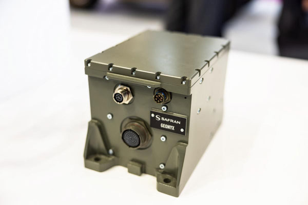
SAFran federal systems’ Geonyx inertial navigation solution, which can be integrated with VersaPNT, Safran’s all-in-one Assured PNT device. (Photo: Safran Federal Systems)
Safran Federal Systems
Safran’s Versa-PNT product coupled with a Geonyx inertial navigator offers rubidium oscillator precision timing, M-Code receiver and navigation-grade inertial technology, all in a package that can support land or maritime operations. More specifically, this package delivers:
P — M-Code receiver.
N — < 0.02% drift over the traveled distance (~2 m over 10 km, GPS accuracy).
T — One-day holdover below 1 µs.
Photo: Spirent Communications
Spirent Federal Systems
The PNT X is Spirent’s innovative sixth-generation simulation platform, which launched at the end of April and will debut at the ION JNC 2024 in June. PNT X offers a new era in NAVWAR testing, with a record 140 dB high dynamic range to simulate high-powered jammers and spoofers. It offers a 2,000+ Hz update rate for a highly accurate representation of the motion of missiles, rockets, and UAVs, thereby guaranteeing the integrity of test results.
The platform includes spatial awareness simulation for jammers and signals of opportunity, overlaying motion on user-defined signals and jammers alongside the simulation of the local environment and terrain.
The PNT X uses Spirent’s custom-built software-defined radios to extend capacity, automation and ease of use for testing current and future PNT sources. Designed for secure environments, the simulation solution features the first M-Code Regional Military Protection (RMP) test capability. Spirent experts are available to assist with generating test scenarios and capitalizing on new automation and interoperability features.
Syntony
The CRPA simulator that we will market together with Keysight will support all available GNSS signals and carrier frequencies. It also will be expandable by a software upgrade to LEO PNT in the near future. With typically four or eight channels,130dB of J/S, and based on the unique generator of Keysight VXG-C (2.5 Ghz instantaneous bandwidth, providing high-level phase synchronization all along the band), it will generate all the GNSS signals in L and S bands through one RF channel, bringing unrivaled performance and ease of calibration.
An interview with Chuck Stoffer, director of business development and Eric Hughes, design engineer at UHU Technologies. Click here to read more from this cover story.
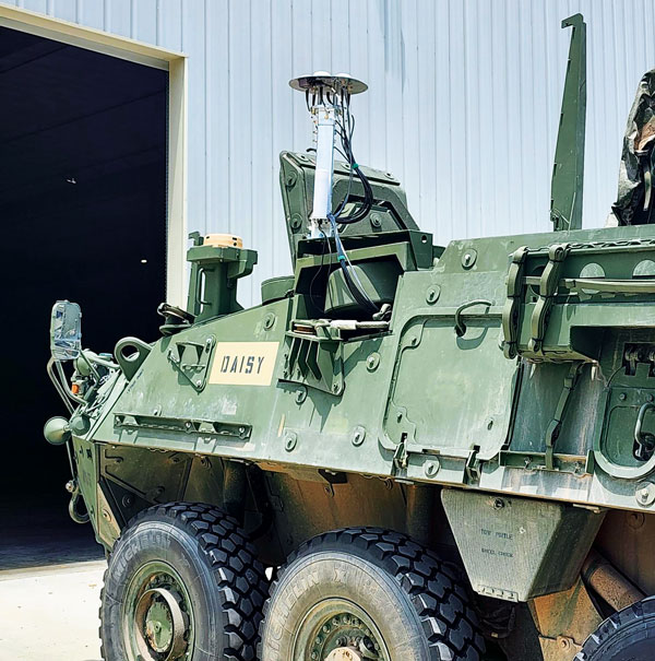
UHU 1000 seven-element antenna array on a U.S. Army Stryker vehicle. (Photo: UHU Technologies)
What is your company’s main differentiator in the market?
CS: Our big differentiator is our ability to detect and mitigate GPS spoofing. There are many products that perform jamming mitigation using multi-element antenna arrays, but they usually don’t operate below the noise floor on spoofers. Our big differentiator is the ability to go underneath the noise floor and locate the spoofing threat.
About 10 years ago, our founder, Jeff Sanders, got interested in the GPS spoofing problem. Jeff’s previous company, Eclipse Electronic Systems, was dedicated to building high-end signals intelligence (SIGINT) receivers and the entire design team here at UHU worked for Jeff there. We built high-end, multi-channel receivers, often used in direction finding applications. When we started UHU, Jeff’s idea was to use direction finding to validate the constellation using satellite position.
EH: Our system looks like an anti-jam system, which it is. However, it does a whole lot more than that. We use a controlled reception pattern antenna (CRPA) to do angle of arrival (AOA) measurements on each GPS satellite.
We know where each satellite is supposed to be, then we calculate where it actually is in the sky. If a satellite is in the right spot in the sky, then we know that we can trust it. If it’s not — and, especially, if multiple satellites are not in the right spot in the sky — then we know there’s a spoofer.
Once we’ve done that, we can take it a step further and perform non-adaptive spatial nulling, subtracting out the bad PRNs from the signals.
Often people look at our system and think, “Oh, it’s an anti-jam system.” Yes, we do anti-jam, just like any other vendor out there would do, and we do the traditional adaptive null steering techniques, so that if there’s a jammer in the environment, we will automatically null it spatially. However, those systems don’t handle spoofers, which, as Chuck was saying, are often below the noise floor. Anti-jam systems — which are using power minimization techniques — will not do anything for something that’s below the noise. In fact, they may inadvertently amplify the weak signal because they weren’t designed to process signals below the noise.
As far as outputs, we provide a spatially validated PNT solution, meaning that we only include satellites whose sky position has been validated. We also provide an RF output that can feed other GPS receivers, including M-Code. Our products have a built-in web-based GUI for visualization of the threat environment, and all system measurements can be sent over the network using multiple industry standard protocols.
To “precisely geo locate the source of GPS jamming or spoofing threats,” as one of your marketing materials says you can do, requires at least two bearings and the range.
EH:One of the nice things about our approach is that once we’ve identified a spoofer or a jammer, we can then tell you the line of bearing or the angle of arrival from the threat. Both of our products — the Northstar and the UHU1000 —also have a built-in event-based I/Q recorder and a GPS-disciplined oscillator that provides precision time. That gives us baseband data with precision timestamps anytime there’s a spoofing or jamming event. This is a standard feature that’s available right now.
You can take multiple systems, network them together, and, if they all have a common view of the interference event, use the provided lines of bearing and precision time-stamped I/Q data to perform geolocation based on AOA and/or time difference of arrival (TDOA). This is a separate appliance that’s in development.
In our next software release we are adding single-receiver, AOA-based geolocation. However, it requires motion. So, if you have a single UHH1000 in motion, you get a coarse geolocation automatically.
CS:We’ve already demonstrated our geolocation algorithms on real-world data and our geolocation appliance is on our roadmap. We’ve proven the technology, and now we’re productizing it.
This works very well for aerial platforms, because you get a lot of motion and many different looks at it. For ground-based applications, where the source could be many miles away and the AOA doesn’t really change much, it might not be as useful.
How it the threat evolving and how are you dealing with that?
EH: One of the advantages of our AOA-based approach is that it’s outside of the signal. It’s a physics thing that is very hard, if not impossible, to spoof. At government-sponsored events, every year they throw a new attack at the participants, often by modifying the signal in some novel way. Those are all great things that need to be tested, but we don’t care about any of that because all we’re doing is checking whether a satellite is in the right spot in the sky. If it’s in the right spot, we trust it. If it’s not, we don’t. Because of that, we’re well positioned to handle new threats.
CS: We individually track every GPS satellite signal that we detect, even the same repeating pseudorandom noise (PRN) code coming from a different AOA. Each PRN gets its own hardware-accelerated tracking loop with its own beamformer. Once we know which PRNs are valid satellites and which PRNs are spoofers, we group and demodulate them separately. We provide the spoofer PNT solutions to the user in real-time.
Are all your boxes multi-constellation?
EH:Today, we process L1 C/A and L2C. Since L1 C/A is the backbone of most GPS receivers, effective spoofing attacks always spoof L1 C/A, and that has been our focus area. Of course, we have a roadmap to do more.
To the extent that you are at liberty to tell me, who has your box? Who will have it?
An exclusive interview with Michael Gavart, CTO of M3 Systems.
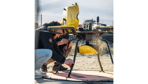
The Boreal UAV ready for departure on a maritime mission scheduled to last several hours. (Image: M3 Systems)
What is your role?
I am responsible for all the technical developments on the UAV.
Please describe it.
It’s fixed wing. It has a 4 m wingspan, a maximum takeoff weight of 25 kg, a carrying capacity of up to 7 kg and up to eight hours of flying time. What is special about this UAV is its size and the size of the payload bay, which is large enough to hold different kinds of payloads.
Do you have different versions?
We have a surveillance version, called BOREAL ISR, that has been used for several projects. Another use case for this UAV is to embed scientific payloads. For example, we had several campaigns for meteorology in partnership with Météo-France in the Indian Ocean to study cyclones and another in the Caribbean Sea to study tropical convection. We did several large scientific campaigns with Météo-France.
Most of the payloads we integrate are for scientific testing. Some of them are for cartography in the visible or infrared domain and other kinds of payloads involve radio frequency testing. Among them, we have, of course, GNSS.
The project we conducted in 2023 was a demonstration campaign for the operational use of this surveillance UAV. The campaign occurred from July to November 2023. It consisted of 20 five-hour flights, three of which were at night. In total during that campaign, the UAV flew more than 100 hours for about 8,000 km and captured data from about 20,000 sq km. This made it possible to identify hundreds of boats fishing illegally. In some cases, the country’s navy intervened and the UAV took live video of the operation to help analyze the scene.
The UAV also flew many operations over the tropical forest, some of them at night, which made it possible to identify some recent mining activities in sites that had already been destroyed some months before.
Another subject was forest fires. During one flight, we identified more than 20 forest fires and the firefighters were able to prioritize where to intervene to fight the fires.
What about flights beyond visual line of sight (BVLOS)?
The radio link enables operators to fly the UAV from up to 100 km from the ground control station, provided that we remain in radio line of sight (RLOS) conditions. Additionally, the UAV has a satellite communication system to fly beyond RLOS in some cases. For some scientific missions, the UAV was flown beyond RLOS conditions using satellite communications, and we could fly up to 250 km from the ground control station.
The Boreal UAV is currently deployed for various kinds of terrestrial applications. (Image: M3 Systems)
When was this UAV first available? What is the market for it?
The first big campaign occurred in 2019, for scientific meteorology over the Indian Ocean. The BOREAL drone LAB, a scientific meteorology drone, was ready to operate in 2014.
A second product, (maritime and terrestrial surveillance use cases) was developed and ready to operate in 2021.
Are you selling large numbers of this UAV or only for some special missions?
Several of them have been sold to laboratories for science. From now on, we sell hours of flights as a service on the ISR product. Each drone is used for specific missions (surveillance in particular).
You rent it out instead of selling it?
We sold UAVs to laboratories and now we sell hours of flights as a service. We don’t rent the product. We have a drone fleet that allows us to conduct several missions throughout the year.
How does all this fit in with M3 Systems’ other products and application areas?
GNSS development requires testing radio frequencies in flight. Our UAV is very useful for testing GNSS payloads. We also have a project to provide payloads for satellites. It is an intermediate step for testing these payloads in the air. The BOREAL drone also leverages the group’s expertise in ATM/UTM, making its integration into the airspace seamless.
What GNSS receiver is on the UAV? Also, what correction networks does it use?
The drone embeds a standard GNSS receiver and uses it for its own navigation needs without corrections service. However, through the PASSPORT project the objective was to demonstrate the added value of OSNMA encryption in the Galileo signal, particularly its anti-spoofing capabilities. To assess this, we needed to conduct a spoofing attack on receivers with the OSNMA functions. We used a Septentrio Polar X 5 receiver. Due to safety concerns, this could not be performed on the drone during flight. Instead, we recorded the IQ signal onboard the drone during the flight campaign and later replayed it in the lab for the receiver. During the replay, we introduced spoofing while OSNMA was disabled on the receiver and showed that spoofing was easily achieved. When enabling the OSNMA service on the receiver, spoofing was still possible but the authentication key was not received, indicating that the signal was not trustworthy.
An exclusive interview with Brandon Malatest, co-founder and COO of Per Vices
What is your title and role?
I’m one of the founders of Per Vices. My friend and I started the company a long, long time ago. I’m a physicist. I attended the University of Waterloo, graduated with an honors degree in physics, and have been working with Per Vices for more than ten years. My role has shifted from doing the actual engineering work to running all the other elements of the company, because as we continue to grow, we can’t be doing everything and that was the logical break. So, I definitely have a technical background, but I’m not the one who’s designing the products anymore.
When was the company founded?
In 2006. Our first commercial product was in 2012. We specialize in designing high performance software-defined radios. These are full transceivers that are used across a very wide range of markets: spectrum monitoring, electronic warfare, MRI, radar, test and measurement markets, communications, radio links — you name it and we’ve done some work in that space. The whole idea behind software-defined radios is that they are very flexible systems. So, with the same hardware platform, you can change the software or firmware, and have it used for a completely different application.
Wonderful. By the way, I grew up among physicists. My father was a physicist for 60 years, the last 35 of which at Brookhaven National Laboratory on Long Island. My paternal grandmother was one of the first women in Europe to get a Ph.D. in physics and math and Enrico Fermi was one of her thesis advisors.
Why is SDR important for autonomous systems?
There are eight major points that I’d like to hit on.
Flexibility. Software-defined radios are reconfigurable, which means that the same hardware platform can be used for many different communication protocols, across different radio bands with varying bandwidth. That makes them very flexible for interfacing with other types of systems. So, in terms of the autonomous systems, there are a number of different wireless devices that need to be interoperable.
SDRs are very flexible radio platforms. They’re designed to have very wide operating frequencies with varying bandwidths so as to replace what used to be done in hardware through dedicated DSP chips, replacing dedicated hardware with a software-based architecture.
From a flexibility standpoint, that means that software-defined radios usually use some type some type of DSP mechanism, like a field programmable gate array (FPGA). That allows the SDR itself to process all types of different signals across varying frequencies and manipulate them in different ways. Anything that’s wireless is basically converting an analog signal to a digital signal and then performing some action on that digital signal. SDRs do that in a different way. They still have the hardware that’s used for tuning, but on the software side the decoding and processing happens. In a traditional FM radio, you have everything done in hardware: it has a dedicated tuning block, a dedicated DSP that does the demodulation, and it spits out the audio. So, the same way that computers, way back in the day, were designed and built from the ground up with one sole purpose — whether it be word processing or running complex trigonometry.
But now, if you look at the utility of computers, it is the fact that you can run different software applications on them. So, the same idea is with SDR. Traditional radio devices were built from the ground up for a single application. Now, SDRs are like a modern-day computer, where you can do basically anything within that tuning frequency. Also, just like with a computer, you change the software and use it for different applications.
Flexibility is definitely one of the most important elements. It allows the user or the system integrator to have an SDR that can adapt to different communication standards and frequency bands. This flexibility is crucial for autonomous systems operating in dynamic environments, where communication requirements may change. So, if you’re suddenly needing to change from operating at 2.4 GHz to operating at 5 GHz due to spectrum congestion or something along those lines, an SDR can do that with the same hardware platform.
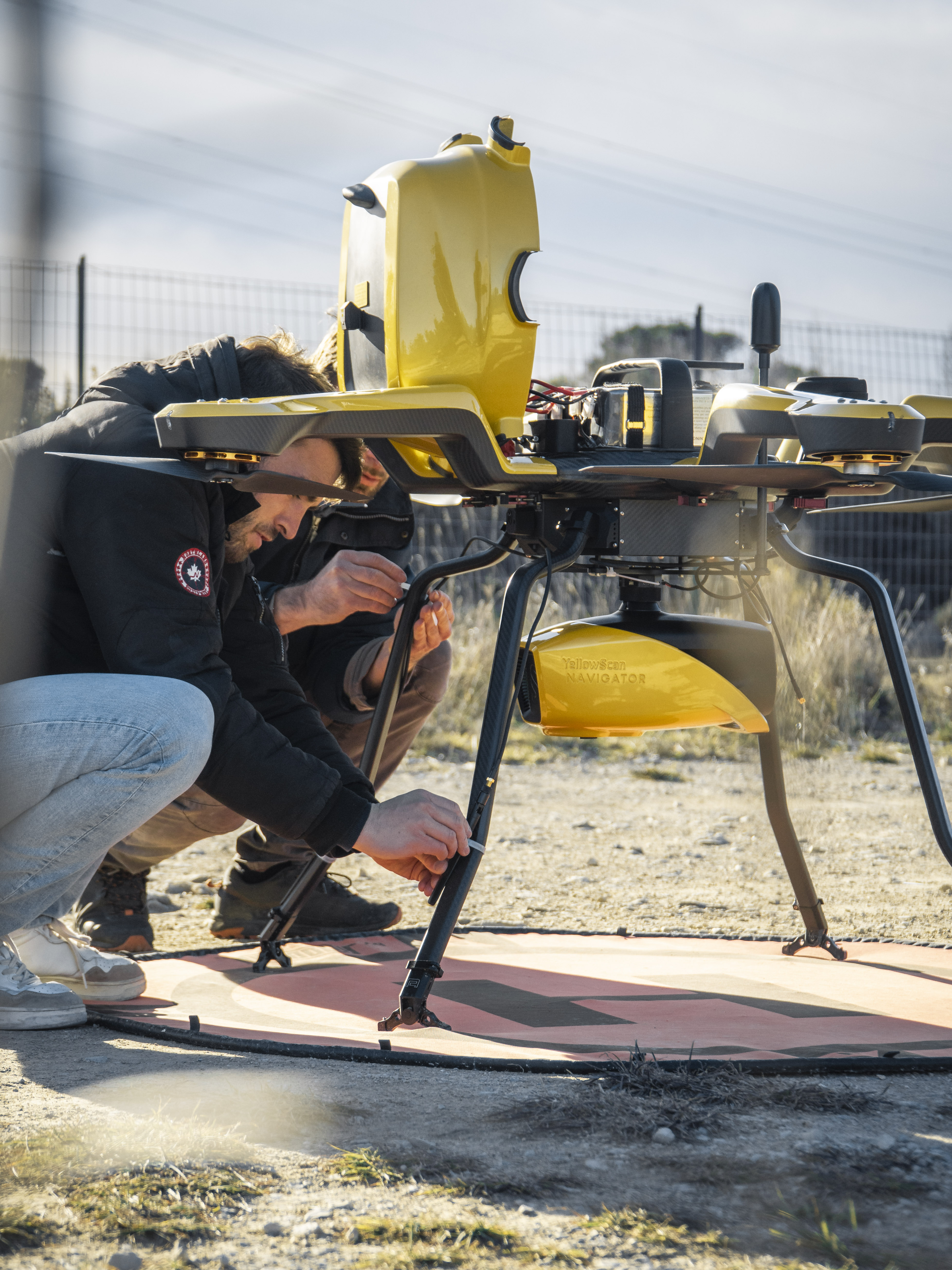
YellowScan’s bathymetric lidar product, the Navigator, mounted on the Noa from Acecore. This full waveform lidar system ensures continuity between underwater points and the surrounding terrain.(Image: YellowScan)
Adaptive communication. Because SDRs tune to various frequency bands and then all the decoding is done in software, they can support different communication standards with the same hardware platform. That enables autonomous systems to communicate effectively with various entities in the environment, such as sensors and additional equipment.
Spectrum awareness. We can call it smart SDRs, or SDRs where you can integrate with AI or you can do your own pre-programming on it. You can monitor different parts of the spectrum to see which is the least congested, so that you can have a clear frequency band of operation to communicate or to use that information for passing data to and from sensors or a command and control system or anything.
Going back to the hardware component, the FPGA onboard acts as a digital signal processing unit. So, SDRs have those onboard DSP units — usually, FPGAs — and that allows for such things as signal modulation and demodulation filtering, waveform generation. All this can be done in real time. It also allows for all the sensor data to be processed very effectively and quickly, with significantly reduced latencies.
Reduced hardware complexity. This relates to putting it all together. When you have the DSP unit and the flexible hardware platform, you don’t really need anything else. So, you can use that SDR to minimize the complexity associated with the overall system. When you’re using multiple disparate technologies, it does become challenging to make sure that they’re all integrated well with one another and work well together. With SDRs, you can really simplify that, that hardware complexity. Then, because SDRs are programmable and customizable, they can be used all the way from prototyping to production. By changing different software or firmware elements associated with the SDR, you can have it operate in different ways. So, if you want to prototype a different communication band that may work better for some environments, you can do that very easily without needing to re-spin new hardware upon new hardware upon new hardware, which gets to be costly and time-consuming.
Remote monitoring and control. SDRs can be set for what we’ll call static operation, where they will perform only one task, to prevent tampering. You can also set them to be updated over the air or through some type of network. So, again, the flexibility is quite significant and it’ll allow you to mitigate different challenges where some of the systems might not be able to be controlled or interfaced regularly from a hardware perspective. That can all be encrypted.
How does your module interface with autonomous platforms?
The analog connection — to external amplifiers or filters, if you need to have very clean use of a particular part of the spectrum — is via SMA connections, which are pretty standard in the industry. On the digital side, there are two different ports. One is an out-of-band communication interface. That’s just a 1 GB Ethernet port that is very common across the entire industry and is used for configuring the SDR. Again, that’s out of band, so you’re not causing any interference with the actual operation. The other one is the digital interface for sending data to and from the system. That can be done over a 10 G interface, a 40 G interface or a 100 G interface, depending on the platform, how much bandwidth you need, etc.
What is your market at this point?
We don’t discuss our customers specifically, because often they are either very large commercial entities that don’t like to have their names disclosed or they are defense prime contractors that don’t want their names to be disclosed either. So, I can’t really get into customer specifics. What I can say, however, is that our SDRs have been deployed in support of many applications, across such systems as radars, early warning systems, MRIs, signals intelligence, spectrum monitoring, low latency wireless links, and test and measurement. There’s definitely been interest in having our systems deployed for a variety of spectrum monitoring applications on UAVs or other autonomous systems where dynamic spectrum control is important.
That’s exactly where our high-performance products fit the bill, because they have a very wide tuning range — from near DC up to 18 GHz, and it offers up to 16 radio chains, where you can monitor every different part of the spectrum continuously.
Are your systems deployed primarily on land, sea, or air platforms?
Primarily on land and air vehicles. Our system is not miniaturized for robots. When you get into sea, it does become a little bit more challenging.
What about small UAVs?
It depends on how small you’re talking about. Often, those small UAVs will use a card, as opposed to an entire system. So, it’ll be a special PCB, that performs just one dedicated function. For some of the UAVs that demand the highest performance, they usually can support a payload of one of our SDRs. They’re not small, but they definitely can support the size, weight and power of one of our higher end SDRs, which are 19” 3U form factor rack-mountable solutions.
What are a couple of use cases or scenarios for autonomous systems?
Interoperability would probably be one of the biggest that keeps creeping up.
Swarms?
Yes. Basically, the ability for the different elements within a system to communicate with one another. The idea would be having some sort of AI or machine learning applied to autonomous systems, which is the future. The problem right now with it is that many of the autonomous systems utilize different communication protocols. That makes it very challenging to have a single set of controls to interface with them.
For us, one of the use cases would be for SDR to be the intermediary. So, capturing the digital data from each of those different frequencies and combining them into one source for that machine learning or AI to utilize. Imagine that you had sensors that were being used for short range radar, long range radar, communications, etc. You will be across the L band, the C band, the 2.8 GHz band, the 5.8 GHz band. You will be across several different protocols. Not all those systems will play well with one another. So, where we fit in is communicating with all of those disparate devices and converting all that data into a digital domain for additional processing to take place.
Another scenario is what we see a lot in our customers who are doing command and control for various tactical systems and want a single platform on their side to interface with all these separate RF devices.
Marking the lines of a soccer field in Vejle, Denmark using a TinyLineMaker Pro X. (Photo. Unicore)
Robotic technology is increasingly integrated into daily life, including applications such as delivery vehicles, automated lawn mowers and line painting robots. Among the critical factors shaping the navigation capabilities of these robotic machines, precise positioning and heading are paramount. Leveraging Unicore’s high-precision GNSS real-time kinematics (RTK) module, TinyMobileRobots, a Danish company, has developed advanced autonomous systems that excel in navigating complex environments.
RTK technology, which greatly compensates for errors in GNSS satellite signals, enables real-time positioning accuracy within 1 cm to
2 cm. The RTK algorithm in Unicore’s UM960 multi-constellation, multi-frequency GNSS module gives it high reliability, precision and fix rate.
Sports fields grounds maintenance teams at schools, parks, housing developments and other locations often need to refresh line markings, which is a very labor-intensive and challenging process. In search of a more rapid and efficient solution, the team marking the lines of a soccer field in Vejle, Denmark, opted for TinyMobileRobots’ autonomous system. This system is becoming popular among groundskeeping teams due to its ability to queue multiple pitches for sequential marking without recalibration, maximizing productivity. It also alerts users when it is running low on paint and estimates its remaining time and distance. The enhanced capacity afforded by the robot’s efficiency also allowed the team to explore new service offerings, such as providing line marking services to other organizations.
The TinyLineMaker Pro X estimates when it will run low on paint and alerts users. (Image: Unicore)
For outdoor robotic applications, GNSS technology’s levels of accuracy range from sub-meter positioning to decimeter and centimeter levels in real time, depending on the specific application. When integrated with complementary sensors such as inertial navigation systems (INS), vision, and radar, robotic navigation can be effectively realized across diverse and complex environments.
Several technologies — ranging from very mature to nascent — are converging to make autonomous vehicles and devices more useful, efficient, and reliable than ever. They include real-time kinematic (RTK) GNSS, inertial navigation systems (INS), cameras, and radar for navigation; cameras, lidar scanners, multibeam echosounders, and a variety of other sensors for data collection; software-defined radios (SDRs) for secure communications; and artificial intelligence (AI) to plan routes, coordinate the movements of multiple autonomous vehicles and devices (including “swarms” of UAVs), and analyze the data collected.
Read this cover story, featuring case studies from Unicore and CHCNAV, interviews with executives at Per Vices and M3 Systems, and images from Frontier Precision and YellowScan.
In one way or another, GNSS is constantly in the news, even though it rarely makes the headlines. Three recent articles prove this point.
Matteo Luccio
The article “Starburst” in the March 4 issue of The New Yorker, written by staff writer Kathryn Schulz, details how the next big solar storm could devastate the U.S. power grid and communication systems and questions whether we are prepared for it. Schulz focuses repeatedly on the key role of GNSS and how devastating it would be if their signals were disrupted by a solar storm. She points out that a large solar storm has not occurred since widespread electrification, let alone in the digital age, and that some scientists now believe there is an approximately 12% chance of an extreme geomagnetic storm striking Earth in the next decade. “The Army,” Schulz wrote, “concerned about overreliance on vulnerable technologies, has reinstated courses in orienteering, and the Navy has resumed teaching sailors how to use a sextant.”
A March 12 article in WISPOLITICS — which bills itself as “Wisconsin’s Premier Political News Service” — reports on a letter from the chairman of the U.S. House Select Committee on the Strategic Competition between the United States and the Chinese Communist Party, Mike Gallagher, to Federal Communications Commission (FCC) Chairwoman Jessica Rosenworcel. Following reports that U.S. cell phones and other devices are receiving and processing signals from Chinese and Russian GNSS satellites, Gallagher asked Rosenworcel whether it is “contrary to FCC rules for handsets and other devices to receive and process signals from unauthorized GNSS constellations.” I have long wondered the same thing. If any of you readers has a firm understanding of this issue, please let me know. Gallagher also asked whether it is “the responsibility of component vendors, device makers, or carriers to ensure that such signals are not received and processed by devices that use GNSS” and whether the FCC has taken any enforcement actions on this matter.
A March 14 article by Elliot Ackerman and James Stavridis in The Wall Street Journal warns that, as its headline says, “Drone Swarms Are About to Change the Balance of Military Power.” Ackerman, a Marine veteran, is the author of numerous books and a senior fellow at Yale’s Jackson School of Global Affairs. Admiral Stavridis, U.S. Navy (ret.), was the 16th Supreme Allied Commander of the North Atlantic Treaty Organization (NATO) and is a partner at the Carlyle Group. “Drones have become suddenly ubiquitous on the battlefield — but we are only at the dawn of this new age in warfare,” they wrote. “[D]ozens or hundreds of drones in AI-directed swarms will have the capacity to overwhelm defenses and destroy even advanced platforms. Nations that depend on large, expensive systems like aircraft carriers, stealth aircraft or even battle tanks could find themselves vulnerable against an adversary who deploys a variety of low-cost, easily-dispersed and long-range unmanned weapons.” While the article focuses on AI and does not mention GNSS, the latter is a key enabling technology for UAVs, as readers of this magazine know well.