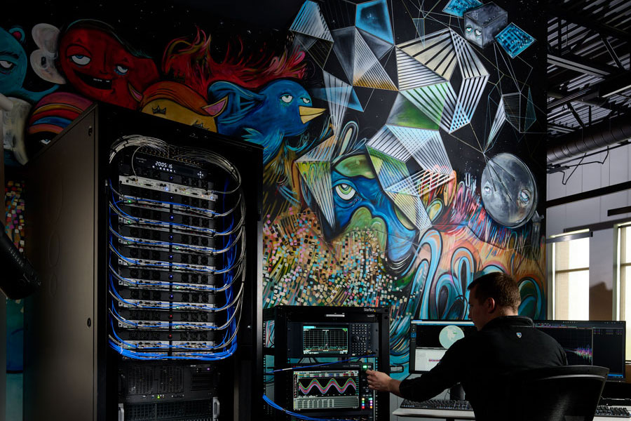
An exclusive interview with Jürgen Pielmeier, managing director, IFEN. For more exclusive interviews from this cover story, click here.
In which markets and/or applications do you specialize?
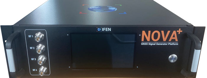
IFEN is offering RF simulation solutions for all GNSS markets, except the defense market with encrypted signals. The major market in recent years was the ‘New Space’ market, mainly focused to design and test PNT navigation solutions as part of (primarily) LEO satellite constellations using existing GNSS systems. With the many new players around the world, there are many market opportunities. To be successful in this ‘New Space’ market requires simulation support of all GNSS systems and signals, modelling LEO dynamics and environment and providing multiple RF-outputs (enabling systems with several GNSS antennas located on the satellite). With our latest ‘NCS NOVA+’ RF simulator, support of up to 4 RF-antenna simulations is possible. From basic RF system up to integrated SIL and HIL systems, the level of required solutions is very diverse by the different applications. The IFEN RF simulator is also offering a full ‘radio occultation’ simulation capability specifically for this market.
The second important market is the automotive/maritime PNT market requiring fully integrated HIL simulation solutions. Excellent integration capability into external environment simulation systems with a rich set of interfaces and short latencies are keys for this market. To further penetrate this market, IFEN will implement some major enhancements during this and next year within its RF simulator products.
How has the need for simulation changed in the past five years, with the completion of the BeiDou and Galileo GNSS constellations, the rise in jamming and spoofing threats, the sharp increase in corrections services, and the advent of new LEO-based PNT services?
Today, supporting all existing GNSS systems with all related signal components on all frequencies is a must have for all high-end RF simulators. Keeping the RF simulators up-to-date with the new and continuously evolving GNSS signals is required to be sustainably competitive. Specifically, beyond the L-band signals, we are also fully supporting the S-band signals of the NavIC constellation. The continuously increasing number of available GNSS satellites and signals requires that the RF simulator capabilities are fully scalable to provide sufficient resources to simulate all signal channels. Our new NCS NOVA+ simulator is our first RF simulator with strong scalability capabilities, to be further extended in the coming years.
In recent years, adding support for the simulation of jamming and spoofing threats was a major driver for the market. Our latest RF simulator generation ‘NCS NOVA+’ is fully supporting all types of jamming and spoofing, fully integrated into our RF simulators to enable coherent signal generation. With the coming ‘DFMC’ (SBAS/GBAS dual-frequency multi-constellation) based safety-of-life and automated driving applications, the need to support advanced jamming and spoofing simulation solutions will be a continuous driver also for the future.
Adding the ‘High Accuracy Service’ (HAS) PPP-correction capability on Galileo E6-B signal in our coming V2.9 release is driven by the increased request for PPP corrections services. We expect further improvements here in the coming years, especially to cover the emerging PPP-RTK market needs.
With the coming age of LEO-PNT services, this is the most important driver for the next five years, extending the signal frequencies beyond the current L- and S-band signals, seeing new modulations, two-way transfer and many more topics. This will require strong development efforts on the RF simulator side, to provide suited RF test tools in time to LEO-PNT system designers and developers, but also the related user terminal developers. IFEN is currently preparing to take this next major step in its RF simulator capability portfolio.
In particular, regarding some of the new PNT services being developed, how do you simulate them realistically without the benefit of recordings of live sky signals?
Facing the lack of live sky signals when developing RF simulator capabilities is a continuous challenge. It requires to a certain signal simulation flexibility designed into the receiver, good and theoretical understanding of specific implications of new designed signals. As soon as real signals are then available, simulation and real signals will be compared and if required the simulation fidelity will be adjusted to meet the real signals.
Are accuracy requirements for simulation increasing, to enable emerging applications?
Concerning the core accuracy parameters requested in recent years, we saw no increase in required accuracy, as the typical requested accuracy are anyway far beyond the real signals accuracy.
Are all your simulators for use in the lab or are some for use in the field? If the latter, for what applications and how do they differ from the ones in the lab? (For starters, I assume that they are smaller, lighter, and less power-hungry…)
Currently all our simulators are designed for usage within the laboratory. However, we recognize an increased request for in-field capable RF simulators, specifically to perform spoofing of real SIS to test deployed GNSS receivers in the field. Offering a portable in-field solution is in the mid-term planning, but not a current driver for our developments.
What are some of your recent successes?
The most important recent success is the Galileo 2nd generation Test User Receiver contract from the European Space Agency. Within this contract, the ‘NCS NOVA+’ simulator as RF test tool will be upgraded to full G2G signal generation capability. The new already implemented G2G signals enabling shorter TTFF, improved acquisition performance but also higher updates rates (e.g. for PPP-RTK). Up to end of the year the G2G signal will be fully implemented in our RF simulator, including the next generation of advanced authentication solutions.
An exclusive interview with Julian Thomas, managing director, Racelogic. For more exclusive interviews from this cover story, click here.
In which markets and/or applications do you specialize?
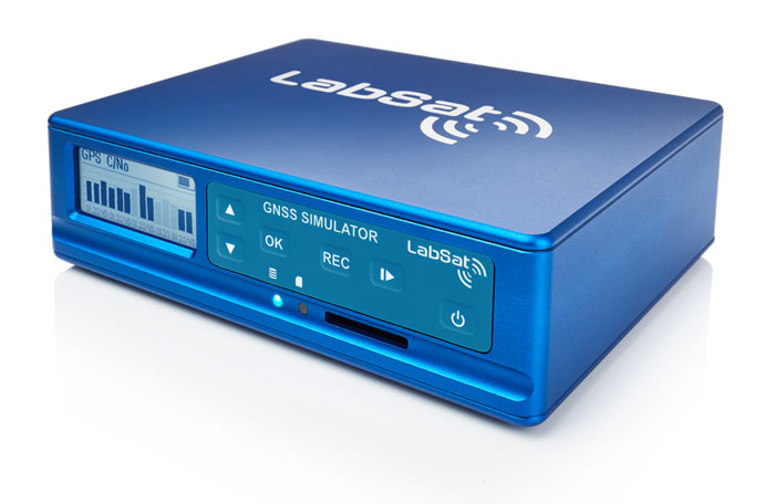
We originally designed our LabSat simulator for ourselves, because we supply GPS equipment to the automotive market. Then, we decided to sell it into that market, which is our primary market, for other people to use. That’s where we started, but it has moved on since then. We supply many of the automotive companies who use it for testing their in-car GPS-based navigation systems.
However, we’ve moved on to our second biggest market, which is the companies that make deployment systems for internet satellites, which use it for end-of-life testing. Several of our customers use it. That’s because we do space simulations, so we can simulate the orbits of satellites. That’s very useful when they’re developing their satellites.
We supply many of the major GPS board manufacturers — such as NovAtel, Garmin, and Trimble — when they’re developing their boards and testing their devices. We supply many of the phone companies — such as Apple and Samsung — and many of the GPS chip manufacturers — such as Qualcomm, Broadcom, and Unicom. More or less any company that’s into GNSS.
How has the need for simulation changed in the past five years, with the completion of the BeiDou and Galileo GNSS constellations, the rise in jamming and spoofing threats, the sharp increase in corrections services, and the advent of new LEO-based PNT services?
It all started off very simple, with just GPS, which was one signal and one frequency. We got that up and working very well and it helped us a lot. Then we got into this market. In the last few years, we’ve had to suddenly invent 15 new signals. We do two systems, really: one is a record-and-replay system. You put a box in a car, on a bike, in a backpack, or on a rocket, and you record the raw GPS signals; then you can replay those on the bench. That requires greater bandwidth, greater bit depth, smaller size, battery power, all of that.
The other is pure signal simulation. We simulate the signals coming from the satellites from pure principles. So, we’ve had to dive into how those signals are structured, reproduce them mathematically, and then incorporate that in into our software. That’s been 15 times the original work we thought it would be, but as we add each signal it tends to get a bit simpler until they add new ways to encode signals, and then it gets complex again. We’ve had to increase our bandwidth, increase our bit depth for the recording to cover all of these new signals.
Because our systems record and replay, they’re used a lot to record real-world jamming. In many scenarios, our customers will take one of our boxes into the field and record either deliberate jamming or jamming that’s been carried out by a third party. Then they can replay that in the comfort of their lab.
With regards to spoofing, we’ve just improved our signal simulation. So, we can completely synchronize it with real time. We can do seamless takeover of a GNSS signal in real time. We can reproduce the current ephemeris and almanac. If we transmit a sufficiently powerful signal, we can completely take over that device. Then we can insert a new trajectory into it. That’s a very recent update we’ve done.
If the complexity and amount of your work has gone up so much in the last few years but you cannot increase your prices at the same rate, what does that do to your business model?
It’s the same people that produce the signals in the first place, so they still have a job. However, as we add more signals and capabilities, we tend to get more customers as well.
Oh, so, you’re expanding your market!
Right, right.
Regarding some of the new PNT services being developed, how do you simulate them realistically without the benefit of recordings of live sky signals?
It is all pure signals simulation. You go through the ICD line-by-line and work out the new schemes. Here’s an interesting anecdote. Our developer who does a lot of the signal development is Polish and is also fluent in Russian. When we were developing the GLONASS signals, he was working from the English version of the GLONASS ICD. He said that it didn’t make any sense. So, he looked at the Russian version and discovered that the English one had a typo. When he used the Russian version, everything worked perfectly. He told this to his contacts at GLONASS and they thanked him and updated the English translation of their document. So, you are very, very much reliant on every single word in that ICD.
Are there typically differences between the published ICD and the actual signal?
No, no. Apart from the Russian one, which had a typo, they’re very good. For example, we’ve recently implemented the latest GPS L1C signal. My developer spent six months recreating it and getting all the maths right and the only way you could test it was to connect it to a receiver and hit “go.” It just worked the first time. He almost fell off his chair. The ICD in that case was very, very accurate.
Hope that Xona’s ICD is just as good.
Yeah.
Are accuracy requirements for simulation increasing, to enable emerging applications?
Yes, absolutely. No one can have too much accuracy. Everyone’s chasing the goal of getting smaller, faster, and more accurate systems. They want greater precision and better accuracy from their simulators, as well as a faster response. We do real-time simulators and they want a smaller and smaller delay from when you input the trajectory to when you get the output. Luckily for us, Moore’s law is still in effect, so, as the complexity of the signals and the accuracy requirements increase, computers can churn through more data. Luckily, we’re able to keep up on the hardware side as well, because much of our processing is done using software. Some companies do it in hardware and some companies do it in software. We concentrate on the software side of things.
Here’s another interesting anecdote from my Polish guy. He noticed that the latest Intel chips contain an instruction that multiplies and divides at the same time but that it wasn’t available in Windows. So, he put in a request with Microsoft for that operational code and they incorporated it into the very latest version of dotnet, which has improved our simulation time by 7%. I see little improvements like that all the time.
Are all your simulators for use in the lab or are some for use in the field? If the latter, for what applications and how do they differ from the ones in the lab? (Well, for starters, I assume that they are smaller, lighter, and less power-hungry…)
All our systems are designed to be used inside and outside the lab. They can all be carried in a backpack, on a push bike, in a car. We do that deliberately, because we come from the automotive side of things, so we have to keep everything very small and compact.
Besides automotive, what are some field uses?
Some of our customers have put them in rockets, recording the signal as it goes up, or in boats. We have people walking around with an antenna on their wrist connected to one of our systems, so that they can simulate smartwatches. There are many portable applications. We have a very small battery-powered version, which makes it very independent.
Are there any recent success stories that you are at liberty to discuss?
Our most exciting one is a seamless transition for simulation that we developed to replace or augment GPS in tunnels. We’ve been talking to many cities around the world that are building new tunnels. Because modern cars automatically call emergency services when they crash or deploy their airbags, they need to know where they are, of course. Cities need to take this into account when they are building new tunnels, which can pass over each other or match the routes of surface streets. Therefore, accurate 3D positioning in the tunnels has become essential. It requires installing repeaters every 30 meters along each tunnel and software that runs on a server and seamlessly updates your position every 30 meters. As you enter a tunnel, your phone or car navigation system instantly switches to this system. It’s been received very well because it’s mainly software and the hardware is pretty simple. We’ve brought the cost down to a fifth of the cost of standard GPS simulators for tunnels. So, we’re talking to several cities about some very long tunnels, which is very exciting.
An exclusive interview with Tim Erbes, Technical Director, Safran Federal Systems (formerly Orolia Defense & Security). For more exclusive interviews from this cover story, click here.
What are currently the key challenges for simulation?
One of our big challenges is determining what performance requirements are necessary for our users. Often, they can’t determine what the specs need to be. All they know is that they need it to work. “I need this receiver from one company, this IMU from another company, and the simulator I got from you guys to work together and I need the performance to match reality.” It can be very challenging to say, “What are the requirements for the simulator? How accurate does it need to be? What types of things matter in this integration?”
Often, we’re left trying to figure that out. So, that’s an interesting, maybe unexpected challenge. It’s easy to look at the datasheet and see what some specs are, but it’s a much harder thing to say, “Well, what do you need the specs to be?” So, we’ve been working with our customers to try to nail down some of those specs, particularly with Wavefront. We have some specs on such things as phase alignment and phase stability. But how do you translate that into something like “Well, I just want the CRPA to work the same in the lab as it does in the real world?” There’s not a direct, easy way to do that. We’re in the middle of trying to figure that out. That’s definitely one of our challenges.
What about the increase in jamming and spoofing threats?
In the last five years, we’ve seen a lot more open talk about jamming and spoofing in the world. The receiver manufacturers must think about this a lot more. What’s interesting from a simulator point of view is that this is not actually new for us. We have the advantage that we’ve been designing to program requirements for years and they have included jamming and spoofing for years. So, in a way, simulation is ahead of this state of the world. Jamming and spoofing are not new or hard ideas for us. In fact, spoofing is similar to simulation. So, we already know how to do that.
Image: Safran Federal Systems (formerly Orolia Defense & Security)
However, jamming and spoofing are new to programs and integration labs. So, there might be platforms where they’re now testing against jamming or spoofing requirements where in the past, maybe they didn’t do that. They certainly can use our simulators to help them do that. However, we’re not seeing a lot of new requirements coming to us saying we need new jamming or spoofing capabilities, because we already have them. Luckily, we are future oriented regarding the jamming and spoofing requirements, so those really haven’t been a challenge for us yet.
That can always change, right? If new requirements come up, such as higher data rates or wider bandwidth waveforms or different types of waveforms, then we would have to adapt and add support for that kind of stuff. As of right now, however, we aren’t really seeing that. So, luckily, we’re prepared for that. As for the industry as a whole, there has definitely been a big movement in the last few years to understand the effects of jamming and spoofing. Simulation is a big part of that.
What about the completion of the BeiDou and Galileo constellations?
For a long time, we simulated four constellations. Then that began to get fuzzy. Do you consider SBAS a constellation or is that just an augmentation? Do you count EGNOS and other supplemental constellations for the other constellations? What about NavIC and QZSS? Before you know it, you start to lose track of exactly how many you have. We just released our 8th constellation, Xona.We’re going to be demonstrating it at JNC.
Tell me more about that.
We are trying to have all the constellations and that can be a fuzzy definition. Does that mean all that are up there right now or all that will be up there in the future? We’re trying to be forward looking and add everything that is going to be up there or might be up there so that lab users can develop and test. Multi-constellation simulation is a particularly challenging problem for groups that don’t have simulators. If you’re just doing research on, say, GPS, and want a new code, you might be able to do that in a lab on your own. But as soon as you say, “I want to do research on whether this LEO constellation helps navigation on a receiver that also uses Galileo and GPS,” suddenly, your research requires a full multi-constellation simulation.
There are two choices. One is to have a simulator do the constellations that already exist, and then you have some research to add constellations. That can be very challenging, especially with time alignment and things like that. The other is to have a simulator that can do all the constellations. That would be the easy choice, right? That presents a problem with such things as LEO navigation being on the rise and these constellations that are just emerging, that are still not even fully defined.
So, we’re trying to build those into our simulation products, to help researchers and decision makers determine whether these will be useful features to add to their receivers or their systems. We have the advantage of having a software-defined architecture. We designed the software so that it is easy to add new constellations to it. Basically, once we’re given a proper ICD, we’re only a couple of months away from a first draft implementation of that new signal. Then we iterate. There used to always be a government-driven, multi-year program to develop an ICD. Now, we have this new concept of the signal manufacturers. We’re seeing private companies release signal specs. That’s a very different way of creating a signal in a constellation. So, sometimes you don’t get much time between when the ICD is available and when simulator users want to use that constellation. Having a software-defined architecture really helps us move quickly. We can add such things as Xona very fast.
Xona told me a couple of days ago that they will soon put out an ICD. What’s the difference between actual signals that you can record and play versus something that’s only on paper?
That’s a great point. Probably many people don’t realize, when they first look at this, that what’s in the ICD and what’s on live sky are sometimes very different. Is the simulator supposed to match live sky? Or is it supposed to match the intended final state of the constellation, according to the ICD? This is a huge topic for M-Code, which is ever changing, and has a very large ICD that’s been released. Space Systems Command/Military Communications & Position, Navigation, & Timing (MCPNT) controls the features and releases them incrementally. We’re constantly having to make changes to the simulator to match those releases. The same is true for the other ICDs. At the Institute of Navigation Joint Navigation Conference (JNC), we will demonstrate an expanded PRN. I think this showed up in the ICD a couple of years ago, but it’s not used by any users yet. Some of the receiver manufacturers are starting to look at using PRNs beyond 32. So, we’re adding that to the simulator. This has already happened for BeiDou as well. I think their ICD goes up to more than 60 satellites. It’s an ever-changing race. The ICDs are constantly being updated and we’re trying to update the simulator.
Image: Safran Federal Systems (formerly Orolia Defense & Security)
Meanwhile, live sky is many years behind the paper, right? This creates an interesting challenge: when you design a system, are you designing it for today or for the future? We have users in both groups. We have users that only care about what is happening today, because they need a model. Maybe you want to model a specific mission and you want to make sure that everything’s going to go properly. Or maybe you’re designing a system that you want to release in three or four years, and you want to make sure that it’s going to work with the state of the system then.
A big challenge is to make sure that we’re keeping pace with all these ICDs. There are more constellations than ever and the technology makes it easier to change signal architectures. We’re seeing signals change faster than we’ve ever seen them change before. We go to conferences and hear about such things as on-orbit reprogramming and signals that might even change specs while they’re being transmitted. Maybe they don’t even have to have a fixed bandwidth or fixed bit rate. We’re going to start talking about signals that can reprogram on the fly. That’s going to make simulation more and more challenging. The technology exists to do this.
Software-defined waveforms is a very logical step. In the software world, we have this concept of version nightmare. When you have 20 different pieces of software that are interdependent, it can get very challenging. We’re going to start to see that in simulators. We’re going to see, “Hey, what version of navigation authentication are you using? We updated it six months ago. Are you using the new one or the old one? Which one should we use?” Well, it depends on what your receiver is using. It’s going to be interesting and challenging to keep all this straight in the next few years as things evolve. Certainly, however, our goal is to be there for all of it and to be as fast and as forward thinking as we can for our customers. That means that we also need to know what our customers need. So, we’re always looking for feedback and requests, what challenges our customers face and we’re responding to those requests.
Tell me more about the difference between simulators used by receiver manufacturers in their labs as they’re tweaking receivers or developing new ones vs. simulators used for mission planning.
The simulators are the same, but they’re used in very different ways. In most lab simulation, what the constellation looks like that day doesn’t matter very much. They can just run with a default constellation for a given day. They’ll run that scenario hundreds or thousands of times and never need to change it because they’re testing parts of the receiver that don’t care a whole lot about the specifics of what’s happening.
Whereas missions are time- and location-specific.
Yeah, exactly. They want to know which satellites will be overhead at an exact time and place. It’s not so much a problem anymore, but there used to be certain days and times when you would not get enough satellites in view, or you might have very bad dilution of precision, and your mission might actually fail. We’re past those days. There are now enough satellites up there. Most receivers will navigate within their specs most of the time in most places. However, for critical missions, such as military operations or rocket launches, you might not want to just assume that any day is a good day. So, if you’re about to launch a rocket, you might want to check. “What does the constellation look like right now?” The challenges that brings is that simulators have a default constellation, but the constellations are constantly changing.
When you’re doing real day mission planning, the big problem isn’t so much how to generate a signal, it’s how to find out what’s happening today. That’s really the nature of the problem because what’s out there today is different from what was happening yesterday or what will happen tomorrow. You might have unhealthy satellites. You need to know that if you want to model them. It becomes a big challenge to get all the right data into the simulator. Once all that data is in there, then it’s the same as any other simulation.
Are there good sources for current data on GLONASS, BeiDou and Galileo?
Image: Safran Federal Systems (formerly Orolia Defense & Security)
There are a couple of websites that provide information about where the satellites currently are. However, we’ve found that each one of those sites has its own challenges. Some are maybe 30 minutes out of date, which is pretty good, but puts the satellites in slightly different spots. Some of those sites only support some of the constellations. We’re talking about multiple countries and they don’t all agree on how this should be done. So, there’s not a single point that you can visit to get all the satellite data. There are a couple of companies that try to fix this. U-blox has AssistNow; Qualcomm has an assist for its cellular receivers; Trimble, NovAtel, and a couple of other companies have their error correction services to which you can subscribe to get some of that data.
If you want real-time up-to-date ephemeris for all the constellations, that is challenging. There are one or two options we have found that seem to work, but they each have their disadvantages. Maybe they don’t have all the satellites. Again, we’re talking about versioning issues. So, if you’ve designed your system with a certain version of an ICD and they’ve added more satellites since, those new SVs maybe aren’t so important for your users, so you don’t publish them. Other users want those satellites. So, we see versioning issues in these data streams. For example, we use the CORS network to get a lot of GPS data but that whole network, as far as I know, is only running the legacy data. As far as I know, no network is distributing the L1C modernized data that we will need at some point. So, as we launch new signals and constellations, we need the networks to provide this new data.
What are some other challenges?
For us, being a software-defined simulator on a platform dependent on software-defined radio (SDR), we’re constantly looking at what’s changing in the SDR technology community. There’s always some interesting stuff happening there that we try to incorporate. We don’t have any big announcements this year, as far as new architectures or anything like that. However, the SDR community is evolving. It’s still a rather new industry. A few years ago, we were an early adopter of SDR technology for mass deployment. Now, we’re seeing some more mature SDRs starting to push such things as channel count and coherency. We will probably take advantage of that in the future.
The other interesting thing technology-wise is that we’re also a GPU-dependent technology. So, as the GPU industry continues to evolve and makes bigger and faster GPUs, we get a relatively low-cost way to upgrade. We don’t have to do a lot of R&D to upgrade to a new GPU. For our users that means that the number of signals they can generate on their simulators is always increasing even using the same hardware from one generation to the next. Our first simulator did 75 signals; the next version did 150. We could build a system that did more than 1,000 signals, but our users don’t need it.
I assume that the growth curve for GPUs is steeper than that for signals.
I think that you’re right about that. I’m sure glad they do, because then something like Xona shows up and we don’t have to rearchitect our system to generate 300 signals, right? At JNC we will show expanded PRN, 300 Xona satellites in the constellation, and a 10 fold improvement on Wavefront performance specs.. We will continue to build simulators that meet our customers’ requirements. Besides GPUs, a lot of the technology involves software R&D and signals. The stuff that we do digitally inside of our system that allows us to do things like extremely precise phase alignment on Wavefront, for example. We spent a lot of time developing that stuff.
Image: Safran Federal Systems (formerly Orolia Defense & Security)
As the number of constellations, satellites, and signals has grown in recent years — especially in the past few years, with the completion of the BeiDou and Galileo constellations — simulator manufacturers have been challenged to keep up. Threats of jamming and spoofing also increased. Then, a few companies began to develop new positioning, navigation and timing (PNT) constellations in low-Earth orbit (LEO).
Due to the limited space available in print, I was able to use only used a small portion of the interviews I conducted for our August cover story. For full transcripts of them see below:
Full interview with Tim Erbes, Technical Director, Safran Federal Systems (formerly Orolia Defense & Security).
Full interview with JulianThomas, Managing Director, Racelogic.
Full interview with Jürgen Pielmeier, Managing Director, IFEN.
Full interview with Mark Holbrow, VP of Product Development, Spirent Communications and Roger Hart, Sr. Director of Engineering, Spirent Federal Systems.
Spirent’s GSS6450 record and playback system (RPS) used to record live-sky signals in an urban environment for testing in the lab.(Image: Spirent Federal Systems)
These are interesting and challenging times for the makers of GNSS signal simulators.
For decades, developers and manufacturers of GNSS receivers have needed to simulate the satellites’ signals to test receivers in their labs and in the field. Meanwhile, users of GNSS receivers for critical missions — such as military operations and rocket launches — have needed to simulate the exact conditions (the number of satellites in line of sight, the positional dilution of precision, etc.) at specific points in time and space.
As the number of constellations, satellites and signals grew — especially in the past few years, with the completion of the BeiDou and Galileo constellations — simulator manufacturers were challenged to keep up. Threats of jamming and spoofing also increased. Then, a few companies began to develop new positioning, navigation and timing (PNT) constellations in low-Earth orbit (LEO). Now, it is common for simulators to require several hundred channels.
I discussed these challenges and the prospect for the simulation industry with representatives of five companies:
Tim Erbes, Technical Director, Safran Federal Systems (formerly Orolia Defense & Security
For the full transcripts of my interviews, click here. If you like this article, you will love the interview transcripts, which cover much more than I had room for here.
Legacy Constellations and New Ones
Simulator manufacturers cite a variety of challenges. According to Erbes, a big one is determining users’ requirements. “Often,” he said, “they can’t determine what the specs need to be. All they know is that they need it to work.” This is particularly true when mixing and matching receivers, IMUs, and components from different manufacturers, he pointed out.
For decades, there were only two GNSS constellations (GPS and GLONASS). A couple of years ago, two more came online (BeiDou and Galileo). Meanwhile, several regional augmentation systems were developed (SBAS, EGNOS, NavIC, QZSS and KASS), some of which may later grow into global systems. Now, new LEO-based systems are being developed. For simulator manufacturers, what was once clear “began to get fuzzy,” Erbes said. “If you ask members of our team right now how many constellations we support, you will not get a quick answer. We’re trying to be forward-looking and add everything that might be up there so lab users can develop and test.”
Multi-constellation simulation is a particularly challenging problem for groups that don’t have simulators, Erbes pointed out. “We have the advantage of having a software-defined architecture. We designed the software so that it is easy to add new constellations to it. Basically, once we’re given a proper interface control document (ICD), we’re only a couple of months away from a first draft implementation of that new signal. Then we iterate.”
In the past few years, said Thomas, Racelogic “had to suddenly invent 15 new signals.” It makes a record-and-replay system — “You put a box in a car, on a bike, in a backpack, or on a rocket, and you record the raw GPS signals,” Thomas said — and another system in which it simulates the satellites’ signals “from pure principles.” The latter, he noted, has been “15 times the original work we thought it would be. However, as we add each signal it tends to get a bit simpler until they add new ways to encode signals, and then it gets complex again.”
Spirent Communications’ technology, Holbrow said, focuses around “its dedicated SDR hardware platform and software simulation engine, which provide performance, scalability and flexibility, within an open accessible architecture. Close collaboration with our selected partners ensures the opportunity to support and integrate new and emerging PNT technologies through their tools, applications and hardware.” Two other aspects that have continued to grow in importance have been “increased realism and test automation,” Holbrow said. “Both are areas in which Spirent continues to prioritize and invest R&D dollars.”
Spirent “can enable the user with effectively an arbitrary waveform simulator or ‘sandbox’ to experiment with different modulation schemes, different chipping rates, codes, bandwidths and navigation data content,” Holbrow said. “The increasing number of signals that we can support multiplies the permutations and combinations of test cases that users can do,” Hart added.
Not every simulator user is equally interested in simulating all the existing and emerging constellations. Those in the U.S. military market do not use foreign signals, pointed out Clark. However, they may want to understand how those signals could impact their vehicle, platform, or individual receiver.
LEO-based constellations “have become a buzzword in the last year or so,” Clark said. Because CAST Navigation’s simulators are modular and use an FPGA-based design, “we can add different satellite constellations or satellite protocols to our system,” he said. “However, we don’t offer anything commercially yet due to a lack of an official ICD, or any kind of documentation that defines any of these new LEO-based signals.”
Today, said Pielmeier, all high-end RF simulators must support “all existing GNSS systems with all related signal components on all frequencies.” Additionally, to remain competitive, they must be kept “up-to-date with the new and continuously evolving GNSS signals.” He added: “Beyond the L-band signals, we are also fully supporting the S-band signals of the NavIC constellation.”
The increased request for precise point positioning (PPP) corrections service, Pielmeier pointed out, was the driver for IFEN to add the High Accuracy Service (HAS) PPP-correction capability on Galileo’s E6-B signal to its next release. “We expect further improvements here during the next few years, especially to cover the emerging needs of the PPP-RTK market.” The advent of LEO-based PNT services, he said, makes this “the most important driver for the next five years, extending the signal frequencies beyond the current L- and S-band signals, seeing new modulations, two-way transfer and many more topics.”
Jamming and Spoofing
Concern about jamming and spoofing has increased significantly over the past several years. These, however, are not new concepts for simulator manufacturers. “In a way, simulation is ahead of this state of the world,” said Erbes. “Spoofing is similar to simulation. So, we already know how to do that.” That could change, however. “If new requirements come up, such as higher data rates or wider bandwidth waveforms or different types of waveforms, then we would have to adapt and add support for that kind of stuff.”
“Because our systems record and replay, they’re used a lot to record real-world jamming,” said Thomas. Regarding spoofing, Racelogic has just improved its signal simulation. “We can do seamless takeover of a GNSS signal in real time. We can reproduce the current ephemeris and almanac. If we transmit a sufficiently powerful signal, we can completely take over that device.”
Over the past five years, most of CAST Navigation’s customers have become much more interested in being able to simulate jamming and spoofing, Clark said. “If you’re doing anything of any importance in a contested environment, you’re going to come up against some type of spoofing and/or jamming interference.”
Pielmeier agreed that simulation of jamming and spoofing threats has been a major market driver in recent years. “Our latest RF simulator generation, NCS NOVA+,” he said, “fully supports all types of jamming and spoofing and is fully integrated into our RF simulators to enable coherent signal generation. With the coming safety-of-life and automated driving applications based on DFMC (SBAS/GBAS dual-frequency multi-constellation), the need to support advanced jamming and spoofing simulation solutions will remain a continuous driver.”
IFEN’s rf signal generator technology, based on a modular and highly flexible Software Defined Radio (SDR) platform. (Image: IFEN)
Simulating What Does Not Yet Exist
The current GNSS constellations broadcast signals that can be recorded, played back, and used to generate accurate simulations. For systems still being developed, however, simulator manufacturers must rely on each system’s ICD, if and when it is available. Even for established systems, the live sky signals may diverge from the ICD. “Is the simulator supposed to match live sky,” Erbes wondered, “or is it supposed to match the intended final state of the constellation, according to the ICD? This is a huge topic for M-code, which is ever changing, and has a very large ICD that is released incrementally. We’re constantly having to make changes to the simulator to match those releases.”
A big challenge for simulator manufacturers is to keep pace with new and evolving ICDs. “There are more constellations than ever, and the technology makes it easier to change signal architectures,” said Erbes. “We’re going to start talking about signals that can be reprogrammed on the fly. That’s going to make simulation more and more challenging.”
Simulating signals for new systems that are not yet deployed is a matter of “pure signals simulation,” said Thomas. “You go through the ICD line-by-line and work out the new schemes. You are very much reliant on every single word in that ICD.”
New LEO-based systems are not the only ones to present this challenge to simulator manufacturers. “L1C is another one of those problem child signals that we have developed,” said Clark. “All we can do is buy all the makes and models of L1C receivers available for sale and utilize our simulator, along with those receivers, to see whether things are good. We’ve asked the government for an L1C code sample, but it will not be available until the satellite manufacturers launch the satellites in their final configuration. Until then, we’ll develop to the ICD that’s been released and defined, then cross our fingers.”
Spirent’s core simulation engine and SDR “are agnostic of the constellation and signal type that’s being generated,” Holbrow said. “So, the underlying principles of accuracy, range rate, pseudo-range control, and delay, together with the RF fidelity from Spirent’s SDR+ Sim engine, can be readily manipulated to simulate the wealth of emerging signals, including LEO.” Additionally, when an ICD is not available, the company can enable its customers to use its tools “to readily populate elements of that ICD themselves.”
In the Lab vs. In the Field
“All our systems can be carried in a backpack, on a push bike, in a car,” said Thomas. “We do that deliberately, because we come from the automotive side of things, so we have to keep everything very small and compact. Some of our customers have put them in rockets, recording the signal as it goes up, or in boats. We have people walking around with an antenna on their wrist connected to one of our systems, so that they can simulate smartwatches.”
CAST Navigation has simulator packages that range “anywhere from shoebox size to nine-foot-tall racks,” said Clark. “They are all modular, so you can add options and capabilities over time. We have simulators that are used in the field. Some of the testing groups with the U.S. armed forces have used our simulators in the back of a Humvee along with other proprietary equipment to conduct their own field experiments.”
Spirent supports in-the-field use cases: its portable simulator can test PNT resilience while the DUT is receiving live-sky signals, and their record-and-playback system takes real-world soundings in a wideband RF environment for playback in the lab.
Currently, Pielmeier said, all IFEN simulators are designed for lab use. However, “we recognize an increased request for field-capable RF simulators, specifically to perform spoofing of real SIS to test deployed GNSS receivers in the field. Offering a portable in-field solution is in our mid-term planning, but not a current driver for our developments.”
Testing vs. Mission Planning
How do simulators used by receiver manufacturers in their labs and in the field to tweak existing receivers or develop new ones differ from those used for mission planning? “In most lab simulations, they can just run with a default constellation for a given day,” Erbes explained. “They’ll run that scenario hundreds or thousands of times and never need to change it because they’re testing parts of the receiver that don’t care a whole lot about the specifics of what’s happening.”
Missions, by contrast, are time- and location-specific. Planners need to know which satellites will be overhead at an exact time and place. “When you’re doing real day mission planning, the big problem isn’t so much how to generate a signal, it’s how to find out what’s happening today.”
Increasing Accuracy Requirements
Like those for receivers, accuracy requirements for simulators are increasing to match those of emerging applications. “Everyone’s chasing the goal of getting smaller, faster, and more accurate systems,” said Thomas. “We do real-time simulators, and they want a smaller and smaller delay from when you input the trajectory to when you get the output. Luckily, we’re able to keep up on the hardware side as well, because much of our processing is done using software.”
As accuracy requirements rise, “Real-world testing has an incredibly important role to play,” said Holbrow. Additionally, as resilience testing places increasing demands on test equipment, Spirent Communications now supports “a multitude of vulnerability and corresponding mitigation/prevention test cases” to deal with jamming, spoofing, cyber-attack and CRPA
CAST Navigation’s simulators meet or exceed accuracy requirements, Clark said. “We have pseudo-range accuracy down to a millimeter, our phase coherence doesn’t wander, and we’re able to achieve 2.5 ps to 3 ps synchronization coherence during multi-element, phased-array antenna simulations. We see our customers interested in a higher performing simulator, and that is our commitment.”
Pielmeier had a different perspective on this: “We saw no increase in the required accuracy, as the typical requested accuracies are far beyond the real accuracy of the signals anyway.”
Recent Success Stories
Racelogic has developed a system to replace or augment GPS in tunnels, which often pass over each other or match the routes of surface streets. “We’ve been talking to many cities around the world that are building new tunnels,” said Thomas. “It requires installing repeaters every 30 meters along each tunnel and software that runs on a server and seamlessly updates your position every 30 meters.”
Clark pointed out that CAST Navigation’s “bread-and-butter” for the past few years has been “larger systems that can drive phased array antennas, along with inertial units, and full high-dynamic aircraft, in real-time environments.” He added that “the smaller systems, which used to be popular, have mostly gone by the wayside.”
As a recent success, Holbrow cited Spirent Communications’ release of a Xona simulator, in partnership with Xona Space Systems, as well as the addition of “many realism-related capabilities, including simulating the vibration and temperature effects of inertial systems;” a cloud-based software application called Foresight that enables users to understand the GNSS coverage they would expect at a particular time, location and trajectory based upon accurate 3D scenes; and a simulation test solution for the Galileo Open Service Navigation Message Authentication (OSNMA) mechanism. Finally, he stressed Spirent’s increasing support for automation.
Pielmeier cited the Galileo second generation Test User Receiver contract that IFEN received from the European Space Agency as its most important recent success. “Within this contract, the NCS NOVA+ simulator as RF test tool will be upgraded to full G2G signal generation capability. The new already implemented G2G signals enable shorter time to first fix (TTFF) and improved acquisition performance but also higher updates rates (e.g., for PPP-RTK). Through the end of the year, the G2G signal will be fully implemented in our RF simulator, including the next generation of advanced authentication solutions.”
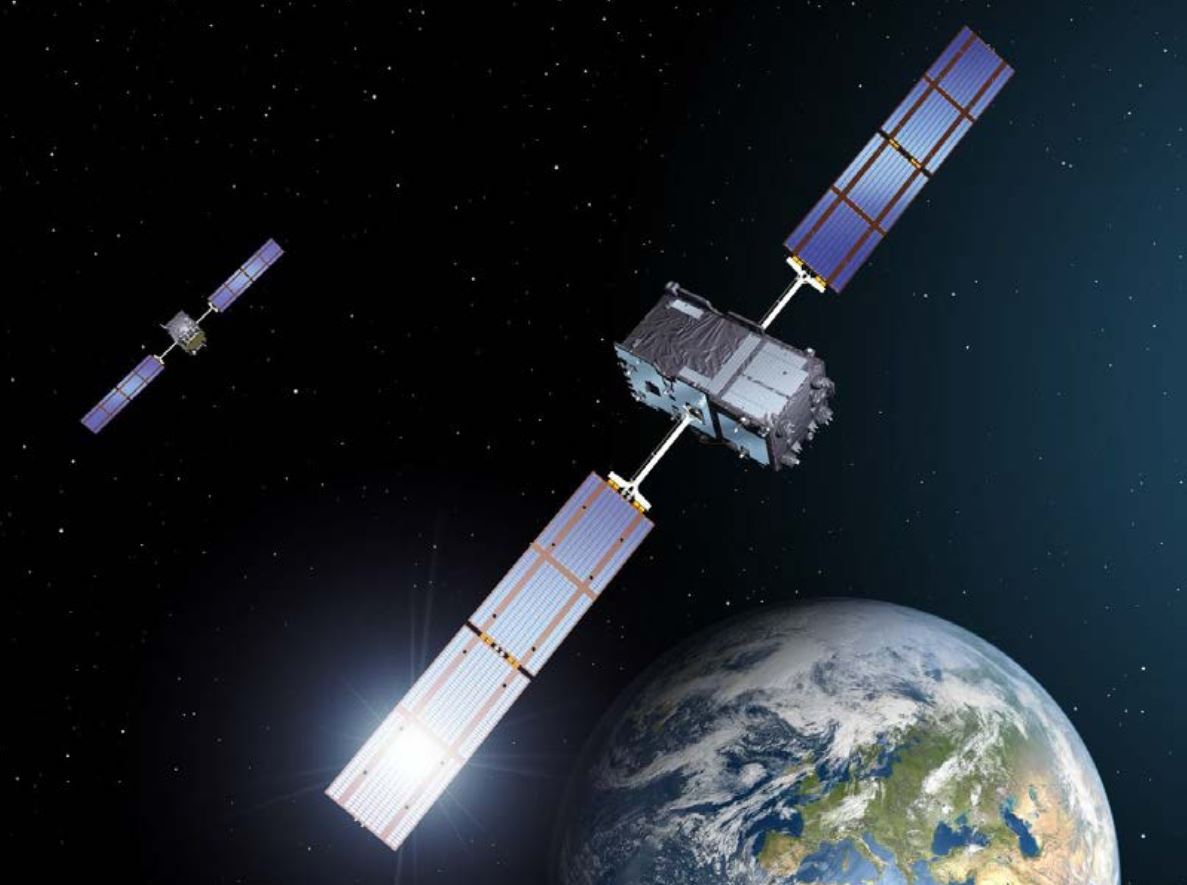
Xona Space Systems has partnered with the Air Force Research Laboratory (AFRL) and the U.S. Space Force under a $1.2 million Direct to Phase II SBIR (Small Business Innovation Research) contract to work toward a secure low Earth orbit (LEO) positioning, navigation and timing (PNT) constellation leveraging Xona’s PULSAR service.
The contract was awarded through an AFWERX SBIR Open Topic, after Xona demonstrated its LEO PNT technology using the “Huginn” demo satellite in late 2022.
Xona is developing PULSAR – a high-performance PNT service enabled by a commercial constellation of dedicated LEO satellites.
The PULSAR service aims to advance PNT security, resilience and accuracy capabilities by augmenting existing GNSS while also operating as an independent PNT constellation.
“Our partnership with the AFRL Space Vehicles directorate and USSF’s Space Warfighting Analysis Center will give Xona the expertise necessary to seamlessly integrate PULSAR into the U.S. national security space architecture,” said Brian Manning, CEO, Xona Space Systems. “Early assessment of unique DOD PNT requirements will set us up for a successful transition to operational service.”
Colonel Jeremy Raley, commander of the Phillips Research Site and director of the AFRL Space Vehicles Directorate, said the investment will contribute to force design analytics that consider contributing signals from multiple orbit regimes.
“Lessons from this effort will pave the way for future defense programs to successfully utilize commercial space assets for flexible and diverse satnav that is resilient to the adversarial threat,” Raley said.
Preceding the award, Xona became the first company to launch a privately funded PNT mission progressing from concept to on-orbit in less than 12 months. Since then, Xona has partnered with major companies such as Hexagon | NovAtel, Septentrio, Spirent, Safran, and StarNav. In April 2023, the company moved into its new headquarters in Burlingame, California, where the company plans to start the production of PULSAR satellites.
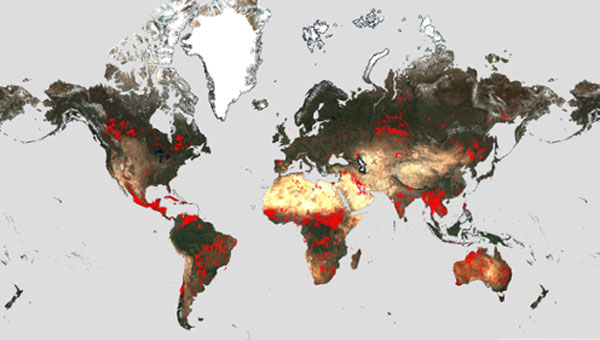
Wildfires have recently spread across Greece, Italy, Spain, Portugal, Algeria, Tunisia and Canada, causing mass environmental and economic damage as well as human casualties. Scientists have warned that wildfires are becoming more frequent and more widespread.
In response, an upgraded version of the World Fire Atlas from the European Space Agency (ESA) is now available. The atlas provides a detailed analysis and map of wildfires across the globe.
Rising global temperatures and the increased extreme weather has led to a surge in the number of wildfires rapidly consuming extensive areas of vegetation and forested lands.
Considering the severe wildfires, ESA has reopened its World Fire Atlas which offers an insight into the distribution of individual fires taking place at a global scale.
Through its interactive dashboard, users can compare the frequency of fires between countries as well as analyze the evolution of each wildfire taking place over time. The atlas was first available in 2019 and it supported both European civil protection agencies and firefighters.
The dashboard uses night-time data from the sea and land surface temperature radiometer (SLSTR) on board the Copernicus Sentinel-3A satellite. Working like a thermometer in the sky, the sensor measures thermal infrared radiation to take the temperature of Earth’s land surfaces which is used to detect the fires.
Data from the Copernicus Sentinel-3B satellite will be added to the atlas in December.
Over the previous seven years, data from the World Fire Atlas show a substantial number of fires detected in Portugal, Italy, Greece, France and Spain.
Data also shows that Canada has experienced 11,598 fires during the first seven months of this year alone. This is a 705% increase compared to fires detected over the same period of the previous six years. Canada is currently battling the country’s worst wildfire season on record, with more than 10 million ha of land burned, which is said to increase in the coming weeks.
The Japan Meteorological Agency (JMA) has reported that on July 10-17, data from GNSS signals indicated continuing minor inflation at shallow depths beneath Mount Ioyama, located on the northwest flank of the Karakuni-dake stratovolcano in the Kirishimayama volcano group in Japan.
Shallow volcanic earthquakes were recorded and vigorous fumarolic activity was visible at the fumarolic on the south side of Mount Ioyama. The alert level remained at two, on a five-level scale, and the public was warned to stay 1 km away from Mount Ioyama.
This JMA report was noted on July 18 in the Weekly Volcanic Activity Report, which is a cooperative project between the Smithsonian Institution’s Global Volcanism Program and the Volcano Hazards Program of the U.S. Geological Survey. The report is updated every Wednesday and averages 16 reported volcanoes.
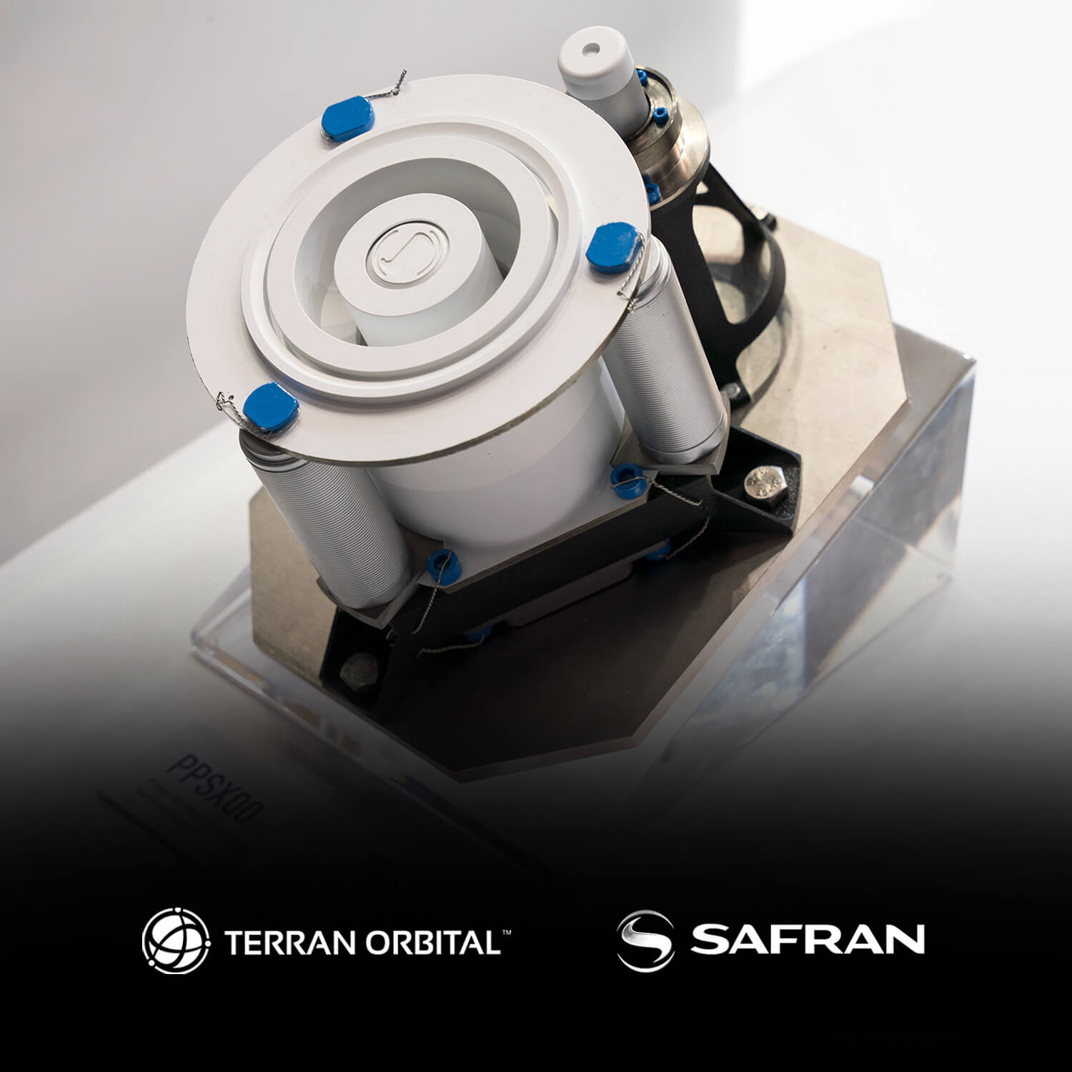
Safran Electronics & Defense and Terran Orbital have partnered to study and validate the prerequisites to produce an electric propulsion system for satellites in the United States, based on Safran’s PPSX00 plasma thruster.
Under the partnership, Safran and Terran Orbital will investigate the technical, industrial and economic prerequisites for Safran’s PPSX00 plasma thrusters are designed to meet the mobility requirements of low-Earth orbit (LEO) satellites, such as offering a higher degree of spacecraft maneuverability to avoid collisions and a system to safely deorbit LEO satellites at the end of their service life.
“Our alliance with Terran Orbital will contribute to the emergence of a complementary source of supply for electric propulsion systems to meet the growing needs of the space industry,” Jean-Marie Bétermier, senior vice president of space, Safran Electronics & Defense, said.
Electric propulsion uses electrical and/or magnetic fields to accelerate mass to high speed – thus, generating thrust to modify the velocity of a spacecraft in orbit.
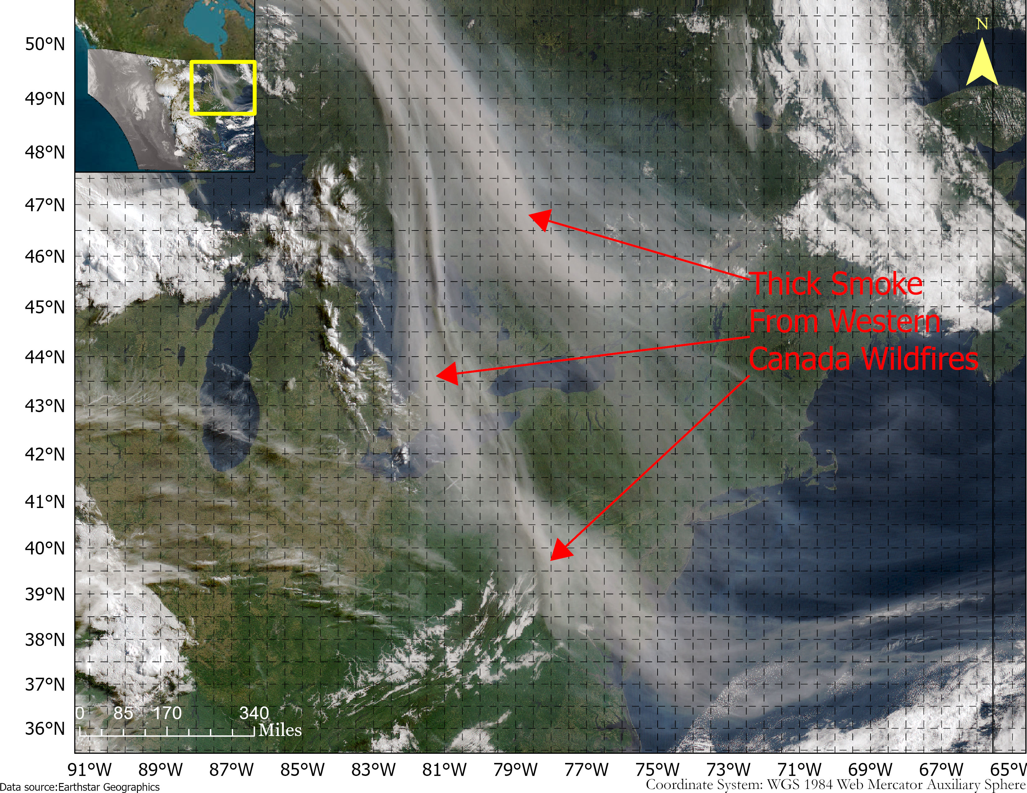
Smoke from the Canadian wildfires continues to pollute the air across the United States, mainly affecting cities in the northeast, including Pittsburgh, Chicago, Cleveland, Detroit and Buffalo.
According to the New York Times, in early June, the level of particulate matter in the air from smoke became so unhealthy that many U.S. cities set records. Visibility decreased in many cities as well, with the smoke creating an orange haze.
Most of the smoke can be attributed to several fires burning across Canada. Many of these fires were caused by lightning; however, with above-average temperatures and dry conditions, wildfires have been breaking out since May.
A storm system off the coast of Nova Scotia forced smoke from the fires southeast into the United States. (Image: NOAA)
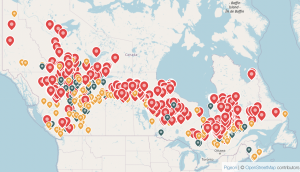
Based on data from the Canadian Interagency Forest Fire Centre, there are 480 active fires in Canada: 252 are out of control, 77 are being held in place, and 151 are under control.
The fires are mapped in the image below.
The red dots represent the out-of-control fires, the green dots are fires being held in place, and the yellow dots are fires that are under control. (Image: Screenshot of CIFFC wildfire map)
Understanding air quality importance
The Air Quality Index (AQI) measures the density of five pollutants: ground-level ozone, particulates, carbon monoxide, nitrogen dioxide, and sulfur dioxide. It was originally established by the Environmental Protection Agency to communicate the cleanliness of the air Americans are breathing every day.
The index runs from zero to 500 — the higher the number the more polluted the air is.
Effects of air pollution can range from mild symptoms, such as eye and throat irritation, to serious ones such as heart and respiratory issues. Pollution can cause inflammation of the lung tissue and increase the vulnerability to infections.
During wildfires, fine particles in the soot, ash and dust can fill the air.
The AQI identifies the concentration of particles smaller in diameter than 2.5 μM. When these particles are inhaled, the tiny specks can increase the risk of heart attacks, cancer, and respiratory infections — especially in children and older adults.
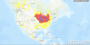
Below is an updated map of air quality from the U.S. AQI as of June 28.
The colors on the map range from yellow — which is unhealthy air quality — to purple, meaning the air quality is hazardous. (Image: AirNow.gov)
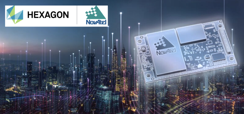
Hexagon│NovAtel’s OEM7 GNSS receivers have successfully tracked Xona Space Systems PULSAR signals generated by a simulator from Spirent Communications. This test proved NovAtel GNSS receivers can track a Spirent simulated L-band signal identical to the PULSAR signal broadcast by Xona’s low-Earth orbit (LEO) satellites.
The Xona LEO signals will complement GNSS, improving resiliency, security, and precision for positioning, navigation and timing (PNT).
“Using Spirent’s simulated PULSAR signal, we have successfully tested our receiver’s capability to track the L-band signal planned to be broadcast from Xona’s LEO satellites,” Sandy Kennedy, VP of innovation at Hexagon’s Autonomy and Positioning division, said. “The OEM7 is a powerful platform, designed for both resiliency and flexibility; it is exciting to test our forethought by trialing this new signal type.”
Septentrio and Xona Space Systems have collaborated to develop an experimental receiver compatible with Xona multi-frequency PULSAR signals.
The multi-frequency receiver will be one of the first to decode all PULSAR signals alongside standard GNSS signals such as GPS, Galileo, GLONASS and BeiDou.
Septentrio will be showcasing this receiver at the ION Joint Navigation Conference, June 12-15, 2023, in San Diego, California.
“As Xona PULSAR signals become available, a Septentrio receiver will offer users an opportunity to be the first to experiment with PULSAR and GNSS in many different scenarios,” Bryan Chan, VP of business development and strategy, Xona Space Systems, said.