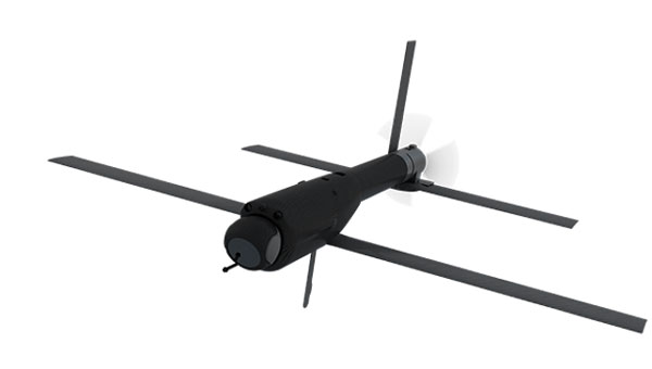
The U.S. Department of Defense (DOD) has spooled up to take the lead in drone warfare with its Replicator 1 program initiative. Securing $500 million in funding in 2023 for “attributable UAVs, DOD is planning another half of a million dollars for the Replicator 2 program. The Replicator initiatives are intended to bring on large volumes of potentially existing capability through increased manufacturing and technological capability. AeroVironment received Rep 1 funding for Switchblade-600 kamikaze drones, which had previously been used successfully in Ukraine, and various initiatives are also underway with many U.S. manufacturers of unmanned surface vessels (USVs), including Anduril’s Dive-LD autonomous underwater vehicles.
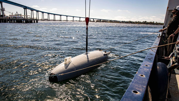
Anduril Dive-LD unmanned undersea vehicle. (U.S. Navy photo by Ian Delossantos)
Having launched contracts increasing the available volume of attack UAVs (loitering munitions), it has been decided that the Replicator 2 program will go after the protection of U.S. forces from enemy drone attacks. Both sides in Ukraine have built up their UAV attack capability, and as a consequence, both sides now need better defenses against offensive UAV threats. DoD has also learned from experience in the Middle East, where its naval assets have suffered from kamikaze UAV attacks in the Gulf.
Inexpensive, commercially available UAVs loaded with explosives and remote control and proximity detonators have proved effective weapons. The next phase of Replicator will seek funding in 2026 for counter small-unmanned aerial system (C-sUAS) initiatives, building up existing capability and technology and developing improved defense capabilities.
Several c-UAS systems have been developed and fielded in recent years, but DOD’s efforts on Directed Energy Weapons are being intensified. High power microwave (HPM) systems can be used to jam UAV communications and disrupt onboard drone electronics such as navigation, guidance, sensors and control systems. Its only drawback is that effectiveness diminishes rapidly with the range from the HPW transmitting antenna. This is due to the increased dissipation of microwave energy in the air with the square of the distance traveled – straight physics. Nevertheless, if you can pump enough power out of the transmitting antenna, say in a narrower beam, you may still be able to cover enough distance to disable an attacking swarm of adversary UAVs, even if it ends up being close in as the UAVs approach the target.
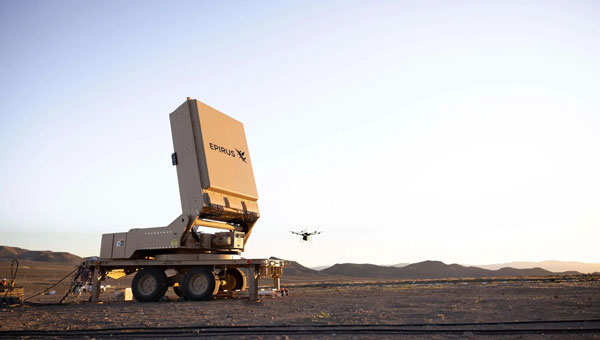
Based in Los Angeles, Epirus recently delivered its Leonidas Expeditionary HPM system under a U.S. Navy contract. The system is mounted on a towed trailer, with the HPM antenna mounted on a turntable to enable directional aiming for a more dynamic ground-based defense against drones. Previous testing has demonstrated the system’s capability to “fry” single and multiple UAVs.
A U.S. Army 2023 contract allowed Epirus to prototype four of the Leonidas systems, which have been delivered to the agency and are potentially slated to find active service in the Middle East. This real-world test aims to shake down the systems under high-stress defensive situations, providing feedback for future improvements if required. The situation on the ground clearly demands improved defensive capability.
Earlier tests of high-power laser defenses in the region allegedly encountered some difficulty with durability and heat dissipation for 50Kw vehicle-mounted systems, while 20Kw laser systems performed better.
It would seem that the high-intensity microwave beams used by the Leonidas systems might be more usable by ground forces. Epirus has reported that a unique approach to power management was one of the initial core elements developed for the Leonidas system, which may affect the ability to form high-power microwave beams.
Earlier defensive approaches have included rifle fire, shoulder-mounted missiles, expensive guided missile defenses, anti-drone drones that collide or throw nets, jamming of the control signals, and, of course, GNSS jamming and/or spoofing. HPM “frying” of multiple drones at a time may be another key defensive approach that may make drone attacks harder for adversaries to inflict on our forces on the battlefield.
So, the next phase of this game could be to develop counter-counter-drone technologies to defeat the defensive systems—this may be a never-ending process.
UAV Navigation-Grupo Oesía has collaborated with SATNUS — a company formed by GMV, Sener Aeroespacial and Tecnobit-Grupo Oesía — as part of the European program Future Combat Air System (FCAS). The program aims to develop a future-generation weapon system (NGWS), which will integrate a new generation of manned fighters (NGF) and multiple remotely piloted air systems (Remote Carriers or RC), all interconnected through a Combat Cloud (CC).
Within the FCAS program, UAV Navigation-Grupo Oesía participates in Pillar number 3 of Remote Operators through a subcontract with SATNUS Technologies SL, which is in charge of maturing technologies and minimizing risks in the development of remotely manned elements of the future generation weapon system. Airbus GmbH is leading this pillar at the European level, with MBDA as France’s lead company and SATNUS as Spain’s lead company.
In the framework of this project, UAV Navigation-Grupo Oesía provides its autopilot for the Manned-Unmanned Teaming and Common Systems Demonstrator (MCSD). This demonstrator, led by SATNUS, will allow the rapid development and testing of concepts and technologies, with a special focus on Manned-Unmanned Teaming (MUT) functions and architecture during phase 1B of the program’s technology demonstration.
The Wall Street Journal has reported mysterious UAVs spotted surveilling some of America’s most sensitive military sites, leaving the Pentagon struggling to respond. These unidentified UAVs have been seen flying over military installations in Virginia and Nevada throughout the past year, including the secret base of the Navy’s elite SEAL Team Six and Naval Station Norfolk, recognized as the world’s largest naval port.
Former U.S. Air Force Gen. Mark Kelly told The Wall Street Journal he first became aware of mysterious UAV sightings in December 2023, when officials at Langley Air Force Base in Virginia reported seeing dozens of UAVs flying over the base at night.
The source of these UAVs remains unknown, leaving officials puzzled about whether they were operated by sophisticated hobbyists or potentially by Russia or China. The complexity and coordination of the flights suggested a level of sophistication beyond civilian drone operations, according to the report.
The U.S. military faced significant challenges in addressing this threat. Federal law restricts the military’s ability to shoot down UAVs over bases unless they pose an immediate threat. Aerial snooping does not qualify as a threat, though some lawmakers hope to give the military greater leeway to address these challenges in the future.
The sightings ended on Dec.23, 2023, with authorities still unsure of the UAVs’ origin or who controlled them. However, a clue emerged in January 2024 when a Chinese student named Fengyun Shi, studying at the University of Minnesota, was caught flying a UAV near Langley Air Force Base. Shi’s UAV got stuck in a tree, which he abandoned before flying to California. The FBI retrieved the drone, discovering it had taken photos of Navy ships docked at the base, which led to Shi being sentenced to six months in federal prison.
In October 2024, U.S. officials confirmed that similar drone swarms had been observed near Edwards Air Force Base in Nevada. The Department of Defense (DOD) has not publicly identified the source behind these surveillance drones.
In response to these incidents and potential threats, Langley Air Force Base is exploring new measures to safeguard its airspace. The base’s 633rd Contracting Squadron issued a notice seeking proposals for installing anti-drone nets around sunshades used for aircraft, including F-22s. These nets are designed to disable small UAVs while allowing quick retraction to ensure flight operations remain unaffected. The proposed system would withstand extreme weather conditions and prevent drones from interfering with aircraft or personnel.
Do you remember the free-standing car navigation devices that were popular for a while, such as those made by Garmin and Magellan? Few people use them anymore because to find our way when driving, most of us use our smartphones instead.
Smartphones now have a plethora of sensors, including inclinometers, accelerometers, magnetometers, barometers and light sensors. However, cost and size constraints (the insides of those small devices are so crowded!) limit the accuracy of smartphones’ GNSS receivers.
Therefore, to accomplish professional mapping tasks, it is now increasingly common to pair a smartphone — which provides computing power, a display, motion sensors, a camera and Internet connectivity — with an external GNSS receiver and antenna.
This and other changes in the industry make product categories long in use obsolete or, at least, less compelling. What is a mobile GNSS solution? Are the terms “mapping grade” and “resource grade” still useful? Who is using which devices for which tasks?
I discussed these issues with Bernhard Richter, VP Geomatics at Leica Geosystems, which is part of Hexagon, and with Igor Vereninov, CEO of Emlid.
— Matteo Luccio, Editor-in-Chief
Leica Geosystems: Conversation with Bernhard Richter, VP Geomatics at Leica Geosystems, part of Hexagon
We used to divide GNSS receivers into consumer grade, resource grade (for GIS data collection) and survey grade.
Those lines don’t exist anymore to the same extent. Some of the lower-cost chipsets — which were originally built for mobile phones and Garmin devices and lower-accuracy stuff — can now provide higher accuracy. We call them industrial-grade chipsets. The need for UAVs, e-scooters, e-bikes, automotive applications, etc., triggered their development. They are coming closer to the premium boards — let’s call them the multi-frequency, multi-constellation receivers that were always built for real-time kinematic (RTK)-type applications.
So, it’s the bottom that’s coming up.
There is still a need for single frequency code-only chips on the one hand for the mass market and, on the other hand, for premium devices from companies such as NovAtel (part of Hexagon), Trimble, Hemisphere and Septentrio. There is a new tier, which we call industrial grade, from companies such as u-blox and Unicore, which come a bit closer to the premium segment.
I’ve always thought of location-based services (LBS) as using consumers’ locations to connect them with retail and services. People use their smartphones to find the nearest coffeeshop, but what has not happened is coffeeshops saying, “Hey, I see that you are within 500 feet of our store. You should come in, because we’ll give you a discount.”
In our field, we make money by providing decimeter- or centimeter-level solutions to our users for surveying, machine control, GIS, etc. When it comes to needing locations for other applications, such as retail, everything is already nicely integrated in smartphones, and consumers just utilize what is there.
In order to get a better precision than the one provided by the cellphone, you need a small, extra GNSS device connected to the cell. Then, instead of using the position provided by the phone, the application will use that much better position. That trend will go on for quite a while. This is the change to what was standard in the last decade, when we built dedicated handheld controllers with fairly high-cost chipsets to enable GIS applications. These GIS devices seem to be disappearing. It’s either an Android or iOS-based phone or tablet, and now you add a hockey puck-type GNSS antenna. Then, you override or mock the position that is coming from the internal chipset on the phone, and the app uses that more precise position. That is the new standard for GIS, so to speak.
Analogously, for a decade we had dedicated car navigation devices. They disappeared because our phones now do that.
Exactly. Where we can really add is in providing that extra bit — not only hardware, but also software and services. Decades ago, we developed the HxGN SmartNet RTK service. Now, we also have HxGN SmartNetGlobal, which is both a terrestrial-based service and augmented by a satellite-based precise point positioning (PPP)-type service. Simple car navigation devices such as those by Garmin or dedicated GIS controllers have almost vanished. It’s always a smartphone or a tablet plus, if a centimeter-level solution is needed, an additional device.
It does not make a lot of sense to fully integrate high-precision GNSS into these mobile devices, because the customer group who really needs a centimeter-type solution is too small, and it would put an extra burden on the engineering for the tablet or the smartphone. Nobody complains if you attach a device that weighs a few hundred grams. I also think that you shouldn’t integrate things that don’t belong together. The different components have different life cycles. A smartphone today is old when it’s 18 months old, right? But, with the volume that’s sold to customers needing high precision, we cannot renew the equipment every year.
Are you talking about a smart antenna?
Today, a GNSS chipset can be as small as a two-Euro coin. However, if you want to do high-precision GNSS, you still need a decent-sized antenna. So, you cannot go to a fingernail size with the antenna element. If you need a good amount of multi-pass mitigation in the analogue way, you need a beer coaster-sized ground plane. Now, typically, you also put in a MEMS-based inertial measurement unit (IMU), so that you do more than just the pure GNSS position — pitch, roll and yaw are important as well.
Phones already have IMUs.
It’s always a matter of what you want. Do you want five meters or one meter or sub-decimeter repeatable at high reliability? Then you need to add more, higher-value components, right? Also, if you just take what’s in an iPhone, it’s not so easy to calibrate those MEMS. Engineers could probably solve the problem, but precision is never the primary goal for a smartphone and would increase complexity.
In addition, in an iPhone, you don’t really worry about aging of the components or whether they can survive a fall from 1.5 m. So, we look at the application and the environment in which the customers are using it, then we select the best components to really add value to, let’s say, the existing iPhone’s position.
In September, we released a high-grade antenna about the size of an ice hockey puck with a very small and tightly integrated GNSS chipset and inertial measurement unit (IMU). Then, of course, we have our own processor to run our positioning engine. It brings in all the corrections that we can provide with our SmartNet service. So, we provide a centimeter solution and pitch, roll and yaw in the most compact form.
Then the phone becomes just the interface.
Yeah, the phone position gets mocked by the position, for example, from a FLX100 plus, and the app takes the better position.
The app is the user’s interface with the puck.
Yes, but the survey device — the “GNSS puck” together with the phone running the app — is only one element of what a typical GIS user needs. Most important are the data themselves and the cloud system that hosts them. The data are the key enablers. If you think of Esri, for example, their value is hosting the data, having the geospatial relationship between the data and enabling decision-making.
The geospatial acquisition part became really easy and can even be done in a tilt-compensated way, so you don’t even need to level your survey pole. The surveyed points are typically automatically synchronized or uploaded to the cloud system. So, if you say that the phone is just the user interface, I kind of disagree.
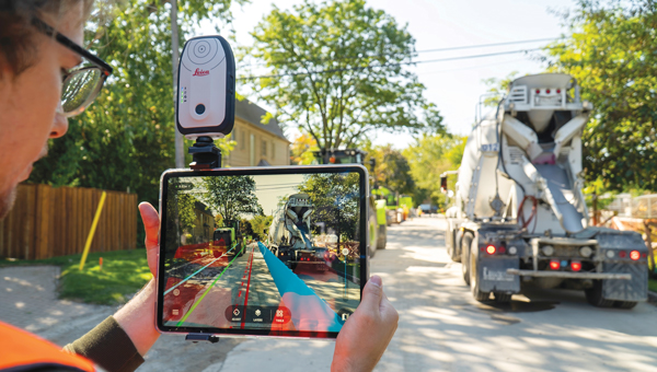
A utility technician using the Leica GS05 GNSS receiver for the surveying and utility industries, which Leica released in September. (Photo: Leica Geosystems)
You’re collecting data and feeding them to the cloud, but they are also on the device to display.
The data themselves are only stored inside the app or in the cloud and can be displayed. The GNSS device itself keeps streaming the position but nothing gets stored there.
How much do you collaborate with ESRI, in terms of their application and the data?
Jack Dangermond [Esri’s co-founder and president] once said, “portal to portal is key these days.” At Hexagon, we have our applications, our industries and our focus areas, and ESRI has its. To me, the way to be successful is to have systems that are compatible and portals that can talk to each other. So, to me, portal to portal is and will be key.
You mean the portals in the cloud?
Yes, they have an API interface and they can talk to each other. I’ll give you one concrete example. We have a product called the FLX100. It is a little puck, has a helix antenna, a receiver engine, but does not have a cellular phone integrated. We’re using the cellular connection of the user’s mobile phone. So, you connect the mobile phone to the FLX100.
We have software called Zeno Mobile One that has an Esri interface. So, we can immediately synchronize everything we measure with ArcGIS Online and ArcEnterprise. This is how we developed our GIS asset collection software. We need an accurate position, of course, which we provide through the hardware that we sell with the FLX100 plus. It can also connect to any RTK service — but, ideally, we connect to our own SmartNet service. As soon as we collect an asset — such as a pipe, a fire hydrant or a manhole — the operator annotates it, “This is a manhole, this is a gas pipe, this is a water pipe,” whatever. Then, the data can be uploaded immediately, already in the right file structure, e.g. into an Esri environment.
We can also run an Esri product, such as ArcGIS Field Maps, on the smartphone and still talk to our hardware. This is very interchangeable these days. If you’re not doing this, I think you limit yourself too much when it comes to data collection. We understand the whole workflow much better than in the past and can be open to certain services, such as Web Map Service (WMS) or Web Feature Services (WFS). You can download the map of your town, then download, let’s say, the entire public water system and load it into this map. Then you can make changes, add new pipes, etc. So, there are many services that enable you to add to an existing map.
So, you’re using Esri’s APIs like anybody else.
Theoretically, you’re right; we use those published interfaces. However, we are Esri Gold Partners, so we really work with Esri to make this happen. There are also open-source products, such as QGIS.
What do you mean by “industrial-grade” receivers?
UAVs doing high precision photogrammetry are one of the biggest market for RTK positioning. However, the highest-end boards from the likes of NovAtel (part of Hexagon) and Trimble are less often used in these applications nowadays. So, UAV manufacturers and operators switched to smaller, lower-cost chipsets. This is one area where this field developed. We are talking about hundreds of thousands of UAVs. So, it became a significant market.
Also, today lawn mowers do not just follow random patterns on lawns. They start integrating those more high-precision chipsets. These days, they are more and more multi-frequency, multi-constellation.
Who’s using something like the puck that you were describing earlier? It’s neither average consumers nor surveyors.
It’s a very good question. We still need to differentiate between the high-precision geodetic market or the scientific market where highest reliability is needed and the GIS market where reliability is of lesser priority. In many cases, such as high multipath, foliage coverage and jamming — there are typically no anti-jamming tools on these lower-cost chipsets — there is a strong need for highest end GNSS cards and a significant difference. Nevertheless, the GIS market is still of significant market size.
Every fiberoptic cable that’s being put underground these days in countries such as Germany, Austria and Italy must be mapped on the open trench. It would be quite costly for those companies who put the fiber optic cables into the ground to call a surveyor each time. So, they train their own technicians to do the job and need many handheld units. We have customers who need 100 crews equipped with the same GNSS equipment. That is the kind of customer group that needs this mid-tier of products.
There are other markets for the mid-tier products, such as photogrammetry, which is coming back because of the improvements in digital cameras and the power of the processors in the field, and then everything with augmented reality. This customer group still needs some control points or RTK positions, but they typically don’t want to spend too much on highest precision equipment.
What is new about the FLX100 plus?
We integrate it into the world of mobile devices in a new way. It is a change from an integrated handheld controller to something that’s separated from the tablet or the smartphone. From an accuracy point of view — if we’re not talking about very challenging cases such as heavy foliage or multipath and 50 km baselines — the FLX100 plus is really good. I think we are at the level where we were with the highest-grade GNSS equipment in 2005 or 2010.
At GPS World, we have used the term “mobile solutions” for a long time but, as the technology changes, it’s hard to use the same categories.
The mid-tier and high-end premium will increasingly blur. So, there isn’t such a clear line anymore. The distinction will disappear, not the equipment itself, for those who want the highest reliability — such as surveyors, who typically earn their living by putting their stamp on a map or a plan and are liable for errors. These customers want the best possible also under very difficult conditions.
Emlid: Conversation with Igor Vereninov, CEO at Emlid
What does Emlid do? How large is it? Where is it based?
We build high-precision RTK receivers and software for them. We are based in Budapest, Hungary, and we also have development offices in Belgrade, Serbia, as well as in Lisbon, Portugal. We are more than 100 people now. We are a diverse bunch, developing everything inhouse — including electronics, embedded software, mobile applications, cloud services and beautifully designed enclosures.
Why did you start the company?
I started the company with my co-founder out of my kitchen, 10 years ago. We started with the idea of making RTK more affordable. Back then, survey gear was very complicated, required a lot of training and was super expensive. We were maybe a bit arrogant, being just out of university, and we thought, “Yeah, we should definitely try to disrupt that.” We built super-affordable receivers, completely crowdfunded on Indiegogo, without any outside capital. Our personal money was very limited, so all the money we had in the company came from our future users.
At that time, our receiver was just a board, but from there we saw so much interest and the orders started to flow. We realized, “Okay, this is going to be big, so we better build a fully recognized and waterproof device that surveyors can use in the field and is not just for DIY hackers and geeks.” That’s how it started.
What came next?
We first had the Reach receiver, which was the board, then the Reach RS, the Reach RS+, the Reach RS2 and the Reach RS2+. Now, we have our Reach RS3, which is super-popular worldwide. We’re now widely known, and our receivers are still very affordable, robust, easy to use and as accurate as any other receiver out there.
To me, the term “mobile solutions” refers mostly to data collection for GIS, but these categories are very subjective. What are the key trends you see in the industry?
A big industry trend is that more and more people inside companies are interacting with centimeter accuracy and with RTK. Previously, it was only surveyors, but now we are seeing that an increasing number of people in the field will have access to accuracy. We play a large part in this story because we democratized RTK and brought it to other professionals outside of surveying.
Traditionally, we had RTK accuracy at one end of the spectrum, a GPS receiver inside your iPad or iPhone at the other end of the spectrum, and in between sub-meter devices, which traditionally occupied the GIS space. Now, customers and potential customers tell me that the sub-meter category is becoming less and less present and attractive. As the RTK technology becomes super accessible and affordable, all the consumers from the sub-meter space are shifting toward centimeter accuracy. Maybe they don’t really need it in the field, but they feel like …
They might as well have it!
Yes, why not just have it, right? It’s the same cost, so why not equip our field crews with centimeter accuracy? We now have easily accessible and affordable, or even free, correction networks. The devices themselves now cost less than $2,000 and are easy to use.
That’s the kind of conversation we are having regularly with customers and potential customers. They’re saying, “Why not have it?” They want to upgrade the accuracy of their mobile mapping device — typically, an iPad. It’s not enough to be able to tell, for example, on which side of the pipeline the valve or junction box is. They really would be fine with 10 or 20 cm of accuracy, but then why not go to that 1 cm level?
Another trend is using iPhones and high-precision GPS for site documentation. We now have deployments of hundreds of units in the field using a combination of an RTK GPS receiver with lidar and camera sensors inside consumer-grade devices, such as iPads or iPhone Pros, to document such things as accidents and construction progress — especially for large infrastructure projects, such as fiberoptic networks.
Your Reach RX, for example, is an external device that talks to a tablet, right?
Yes. We’re seeing the use of our receivers in combination with the sensors inside an iPhone to document objects with very high accuracy and with absolutely no training by the person doing the job. You really don’t need a trained person to do it. For example, an excavator operator — who is not typically doing any kind of mapping but is a professional in a different space — would be able to grab an iPhone with an external RTK receiver and map things with centimeter accuracy for reporting purposes.
I find it very exciting that we’re able to use this mix of consumer-grade technology with RTK that is rapidly becoming very affordable. Together, they give us a platform that allows us to document things super-efficiently and bring it into the hands of more professionals. We are seeing more and more startups in that space as well.
All your receivers are GNSS receivers, correct?
Yes, everything that we make is all-constellation and multi-frequency GNSS.
A surveyor using an Emlid mobile RTK network rover, a Reach RX, in an urban environment. (Photo: Emlid)
What are the main end-user applications for your devices?
We sell a lot to land surveyors and to drone pilots. Many drone pilots are increasingly becoming surveyors, and many surveyors are increasingly becoming drone pilots. So, those two groups of people are moving toward each other, and we are happy to serve both. Our devices are very popular and are the standard for drone workflows. This is a big market for us. Also, construction and mobile scanning.
What about utility companies mapping their assets?
Yes, we work with businesses that need to manage some kind of infrastructure or a large collection of assets. Water companies are very big users. They have many undocumented areas and a lot of people working in the field. For them, it’s crucial to have an affordable system that they can put in the hands of untrained people. Also, fiber optic networks, gas pipelines and agricultural companies have similar demands.
Today, a traditional RTK GNSS receiver costs at least $20,000. Our Reach RX is $2,000; our Reach RS3 with tilt compensation is $3,000. This completely changes the game. So, we are opening this field for professionals, for architects, for landscape designers, for agricultural applications. We’re seeing archeologists use it. These guys would have never bought a system for $20,000 or $30,000. Now that it’s $2,000 or $3,000, it’s a different story.
What do you make specifically for GIS?
We recently introduced the Reach RX MFI, which is certified for use with Apple devices. This Reach RX integrates natively with Esri’s ArcGIS Field Maps, the most common platform for GIS data collection workflows. It required certain hardware modifications to connect to iPhones natively and some integration work with Esri. It is another way in which our Reach RX receiver can be used. Every one of our Reach RX is now a Reach RX MFI.
Tell me about the Pix4D.
We have a kit that consists of two parts. The hardware part is our Reach RX centimeter-grade, survey RTK receiver. The software part is the PIX4Dcatch mobile app on an iPhone Pro or Pro Max, which has a lidar sensor and a very good camera. As a part of the kit, you receive a bracket to mount everything together, forming a unique system that is easy to use, accurate and affordable. It uses the lidar for scanning.
And the sensors in the phone to determine its attitude …
Yes, and the huge photogrammetry experience that Pix4D has. They’re using their full photogrammetry engine to process the pictures, along with the lidar from the iPhone and highly accurate GNSS, which allows them to stitch together essentially survey-grade models just using this simple set of equipment.
I’m very excited about this technology being so accessible and easy to use.
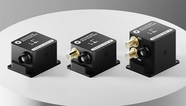
Advanced Navigation has expanded its Certus product line by introducing the Certus Mini series. This development marks a significant advancement in compact and high-performance navigation technology for field robots, autonomous vehicles and UAVs.
The Certus Mini series comes in three variants:
Certus Mini D: A dual-antenna inertial navigation system (INS)
Certus Mini N: A GNSS-aided INS
Certus Mini A: An attitude and heading reference system (AHRS)
These lightweight systems, weighing no more than 55 grams (1.9 oz.), offer impressive performance and cost-efficiency for their size.
The Certus Mini D utilizes dual-antenna GNSS for accurate heading, position, and velocity measurements. It operates on L1/L5 multi-constellation GNSS and offers enhanced interference immunity and position accuracy, particularly in challenging urban environments.
The Certus Mini series is designed to integrate into legacy systems and new builds. Its versatility makes it suitable for various applications, including surveying, agricultural robotics, open-pit mining and asset tracking.
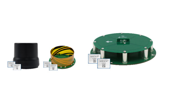
Harxon has introduced a new line of smart antennas that seamlessly integrate advanced antenna technology with a comprehensive real-time kinematic (RTK) positioning module. These products offer high-precision positioning capabilities within a compact and easily integrable form factor, making them ideal for various applications.
The smart antennas incorporate full-constellation, full-frequency RTK positioning modules, enabling a range of accuracy levels to suit different needs. Users can achieve single-point meter-level accuracy, DGPS sub-meter-level accuracy or RTK centimeter/millimeter-level accuracy depending on their requirements.
The series includes both housed and embedded versions tailored for specific use cases. The HX-MR401A and HX-MR402A are housed versions, while the HX-ME403A and HX-ME404A are embedded versions designed for UAVs. These models leverage Harxon’s low-profile helix antenna technology. For robotic lawnmowers, Harxon offers the HX-ME401A and HX-ME402A, which are based on the cost-effective and high-performance OEM GNSS Antenna HX-CSX231A26.
Photo: Harxon
OEM GNSS antenna
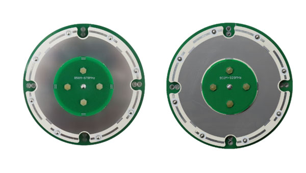
Harxon has expanded its OEM GNSS antenna lineup with two combined antennas: the HX-SE402A and HX-SE403A. These full-band, full-frequency antennas integrate GNSS capabilities with a low-profile radio antenna that supports the 858-878MHz and 902-928MHz frequency bands. This addresses the growing need for devices requiring both navigation and communication functionalities.
Unlike traditional whip-shaped radio antennas, which can extend up to 20 cm, Harxon’s new low-profile technology achieves the same functionality at 10 mm height, which allows for greater versatility in applications that demand precise positioning alongside wireless communication. Additionally, Harxon offers custom tuning services to optimize integration into OEM end-user modules for specific applications.
Photo: Harxon
Anti-jamming GNSS antenna
Harxon has introduced its inaugural series of anti-jamming antennas, starting with two initial models: PT023 and PT024. These GNSS antennas are specifically engineered to operate in challenging environments characterized by complex electromagnetic interference, high-power signals and strong multipath effects.
They are well-suited for scenarios involving low-elevation angle interference, high-power interference sources and radio communication system noise. The PT023 model utilizes multiple array elements combined with amplitude and phase manipulation to achieve spatial radiation shaping. This antenna also incorporates advanced multi-level filtering technology, effectively suppressing out-of-band noise power.
In contrast, the PT024 model features vertical and horizontal two-dimensional polarization suppressors. This design effectively mitigates the reception of both odd and even LHCP and RHCP signals originating from the rear of the antenna, according to the company. It can also suppress low-elevation multipath signals at the same frequency and out-of-band noise signals. These features collectively enhance the antenna’s performance in complex electromagnetic environments.
SPH Engineering and Radar Systems, Inc. have developed the Zond Aero 500 NG, a versatile ground penetrating radar (GPR) system designed for both terrestrial and drone-mounted surveys. This dual-purpose GPR is suitable for various applications, including utility scanning, sinkhole detection, glaciology and geological studies.
The Zond Aero 500 NG features dual-mode operation, allowing users to conduct both ground-based and airborne surveys. This flexibility enhances the data collection methods available to operators. The system includes a center frequency of 500 MHz, an operating bandwidth of 200-900 MHz (-12 dB), a sampling rate of 25,600 samples per second and a scan rate of 50 scans per second. It can achieve depth penetration of up to 4 m in average soil conditions, making it effective for a range of subsurface investigations.
It is designed to deliver high-quality data through advanced electronics and real-time to enhance the signal-to-noise ratio significantly. This improvement enables the detection of finer details and deeper anomalies within the surveyed area. Additionally, the system is compatible with DJI Matrice 300/350 UAVs for airborne applications.
The system’s data is recorded in real time as radiolocation profiles (radargrams), which are stored for further processing and interpretation. The data is saved in the standard geophysical SEGY format (.sgy) with geotagging for each trace to offer accurate analysis and reporting.
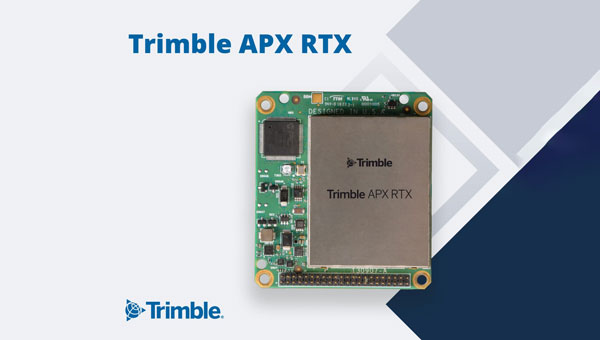
Trimble has introduced the APX RTX portfolio, a new line of direct georeferencing solutions designed for UAV mapping sensors. This system enables high-accuracy mapping across diverse environments, ideal for OEMs and UAV payload integrators.
At the core of the APX RTX portfolio is the Trimble CenterPoint RTX technology, which offers both real-time and post-mission direct georeferencing. This capability allows for centimeter-level accuracy without the need for base stations, making it compatible with various sensors, including cameras, lidar and hyperspectral mapping devices.
The system’s hardware features include a compact GNSS inertial unit that supports real-time positioning. Additionally, external inertial measurement unit (IMU) support is an option to enhance orientation accuracy. The portfolio also utilizes high-accuracy MEMs calibrated with Trimble Applanix SmartCal compensation technology to improve precision.
It is embedded with compact, survey-grade GNSS inertial hardware that delivers real-time positioning and highly accurate roll, pitch and heading measurements. It includes four variants for mapping at different flying heights and beyond visual line of sight (BVLOS), enabled through greater orientation accuracy.
The Trimble Applanix IN-Fusion+ multi-sensor aided inertial technology leverages Trimble ProPoint GNSS technology to offer consistent performance in various environments. The APX RTX portfolio offers the Trimble CenterPoint RTX Complete subscription to streamline workflows. This subscription combines real-time functionality with post-processing capabilities in POSPac UAV, eliminating the need for separate licenses or internet connections.
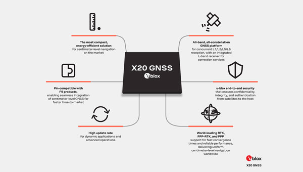
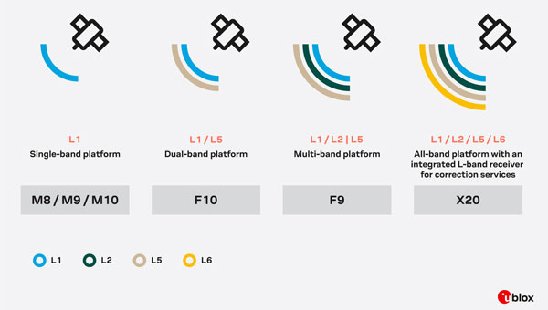
u-blox has introduced the X20, a new high-precision GNSS platform that builds upon its previous F9 platform. The X20 is designed to meet global demands for high-precision GNSS capabilities while accommodating future technologies and standards.
The X20 operates across all GNSS frequency bands (L1/L2/L5/L6) and includes an integrated L-band receiver. The L5 band operates at lower frequencies, which can improve signal robustness, while the L6 band is used for navigation and correction services to enhance positioning accuracy. This comprehensive coverage allows for high-precision positioning even in challenging signal environments.
The platform supports various correction services, including local base stations, real-time kinematics (RTK), network RTK, precise point positioning (PPP) corrections and PPP-RTK.
It is suitable for applications requiring centimeter-level positioning accuracy under challenging environments, such as port logistics, construction machine control, UAVs, autonomous ground robotics (e.g., lawnmowers) and time synchronization for critical infrastructure systems.
The X20 platform incorporates comprehensive security measures such as end-to-end security functions, system authentication via secure boot and firmware updates, message authentication and encryption with a built-in secure root of trust (RoT).
It supports Galileo OSNMA authentication and features advanced jamming and spoofing detection and mitigation. The X20 platform is designed to be software upgradeable, allowing users to adapt to future developments in GNSS technologies and standards.
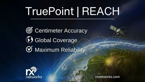
Rx Network has launched TruePoint | REACH, an advanced, hardware-agnostic, cloud-based correction service designed to deliver centimeter-level location accuracy worldwide for various professional applications.
TruePoint | REACH offers precise centimeter-level positioning to enhance GNSS receivers’ performance in applications such as precision agriculture, machine control, mining, marine operations, UAV, GIS and more. The service is compatible with leading commercial off-the-shelf receivers using the RTCM 3.3 SSR and the 3GPP LPP SSR format. The company said key hardware partnerships are in the planning stages and will be announced soon.
TruePoint | REACH eliminates the need for users to set up their own base stations. Users can achieve centimeter-level accuracy by connecting receivers to the cloud while leveraging Rx Networks’ comprehensive global coverage.
Its correction engine is built to provide centimeter-level accuracy worldwide and can achieve sub-3cm precision in under 10 minutes. This makes it suitable for applications that require moderate initialization times for high-precision services.
A test version of TruePoint | REACH is available for those interested in assessing its capabilities. Users can sign up for a complimentary 30-day trial license through the Rx Networks website.
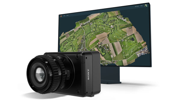
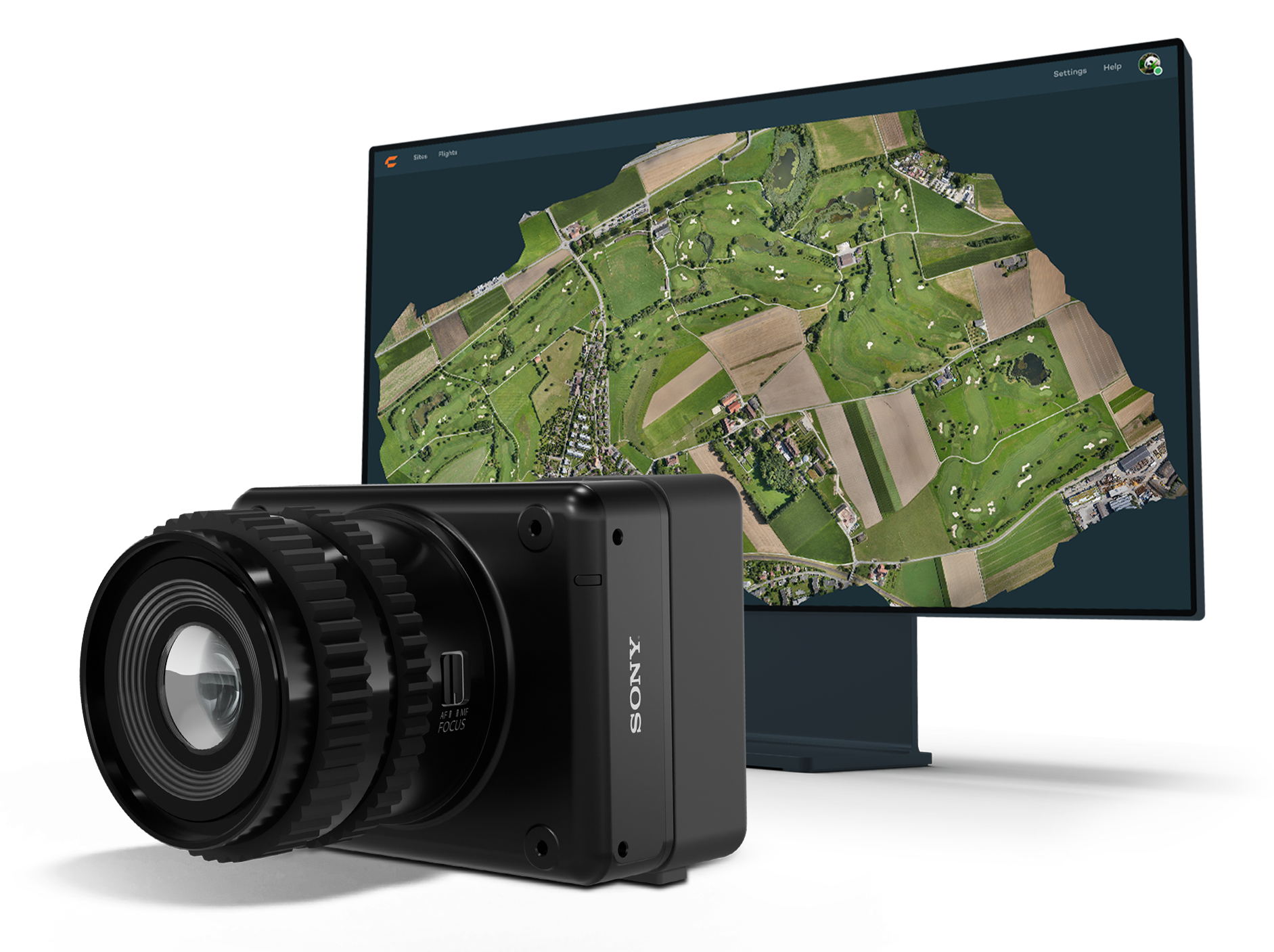
Wingtra has launched the MAP61 mapping sensor, designed to assist professionals in generating larger mapping outputs more efficiently. This ultra-high-resolution sensor offers detailed 3D data in a single pass, providing valuable analytics for vertical assets.
The MAP61 can cover up to 460 hectares (1,140 acres) in a single flight, reducing fieldwork time and enhancing productivity. According to Julian Surber, product manager at Wingtra, the MAP61 can decrease fieldwork time from one hour to approximately 35 minutes while doubling processing speed. This efficiency is beneficial for projects requiring both 2D and 3D data.
MAP61 features oblique sensor configuration, which can facilitate detailed mapping of long structures such as highways without interrupting traffic flow. This design reduces the need for cross-hatch flights, cutting field time in half for vertical resolution and accuracy, which is critical in industries such as construction.
The MAP61 is versatile and suitable for various applications including land management, urban planning, highway mapping and progress monitoring in open-pit mines. Its ability to operate efficiently in challenging environments — such as urban areas or open pit mines —makes it a valuable tool for professionals who need timely data.
The system can integrate seamlessly within an intuitive mapping workflow. Wingtra combines vertical take-off and landing (VTOL) capabilities with its software platform, WingtraCLOUD. This integration allows users to plan, capture and process data without switching between different software applications.
u-blox and Topcon Positioning Systems have formed a strategic partnership to develop a high-precision GNSS positioning service for the mass market.
The partnership was formed in response to the increasing demand for GNSS precise positioning across various applications. According to a recent EUSPA report, services enabled by GNSS devices are projected to generate approximately 80% of total GNSS revenues by 2033.
The comprehensive GNSS correction services will serve a wide range of applications requiring precise positioning, including automotive, industrial, robotics, construction, precision agriculture and mobility sectors. These services will integrate with u-blox’s current and future hardware products, as well as existing services such as PointPerfect.