Tag: autonomous vehicles

  • Building the future of localization: how GNSS+IMU and VPS work together

    Building the future of localization: how GNSS+IMU and VPS work together

    Accurate localization underpins modern mobility, powering everything from precise rideshare pickups and efficient deliveries to augmented reality and autonomous systems. Yet achieving reliable sub-meter precision with commodity hardware remains one of the field’s central challenges.

    A range of technologies are being explored to improve positioning, such as real-time kinematic (RTK) and Precise Point Positioning (PPP) corrections, 5G methods standardized under the 3rd Generation Partnership Project (3GPP), simultaneous localization and mapping (SLAM), light detection and ranging (lidar), inertial measurement units (IMUs), and ultra-wideband (UWB). Each plays a role in specific contexts, but for everyday, mass-market deployment, two paradigms dominate the conversation: visual positioning systems (VPS), which rely on cameras and computer vision to match images against reference databases, and GNSS plus inertial measurement unit (GNSS+IMU) sensor fusion, which integrates satellite positioning with inertial data already present in billions of devices.

    These two approaches are not mutually exclusive. VPS works best in dense urban areas where GNSS can struggle, while GNSS+IMU excels in the open environments where VPS has fewer features to recognize. In practice, VPS even depends on GNSS to help narrow the search space in its visual database. That makes the two technologies natural complements, and together they provide the building blocks for the next generation of spatial intelligence.

    The Role of VPS

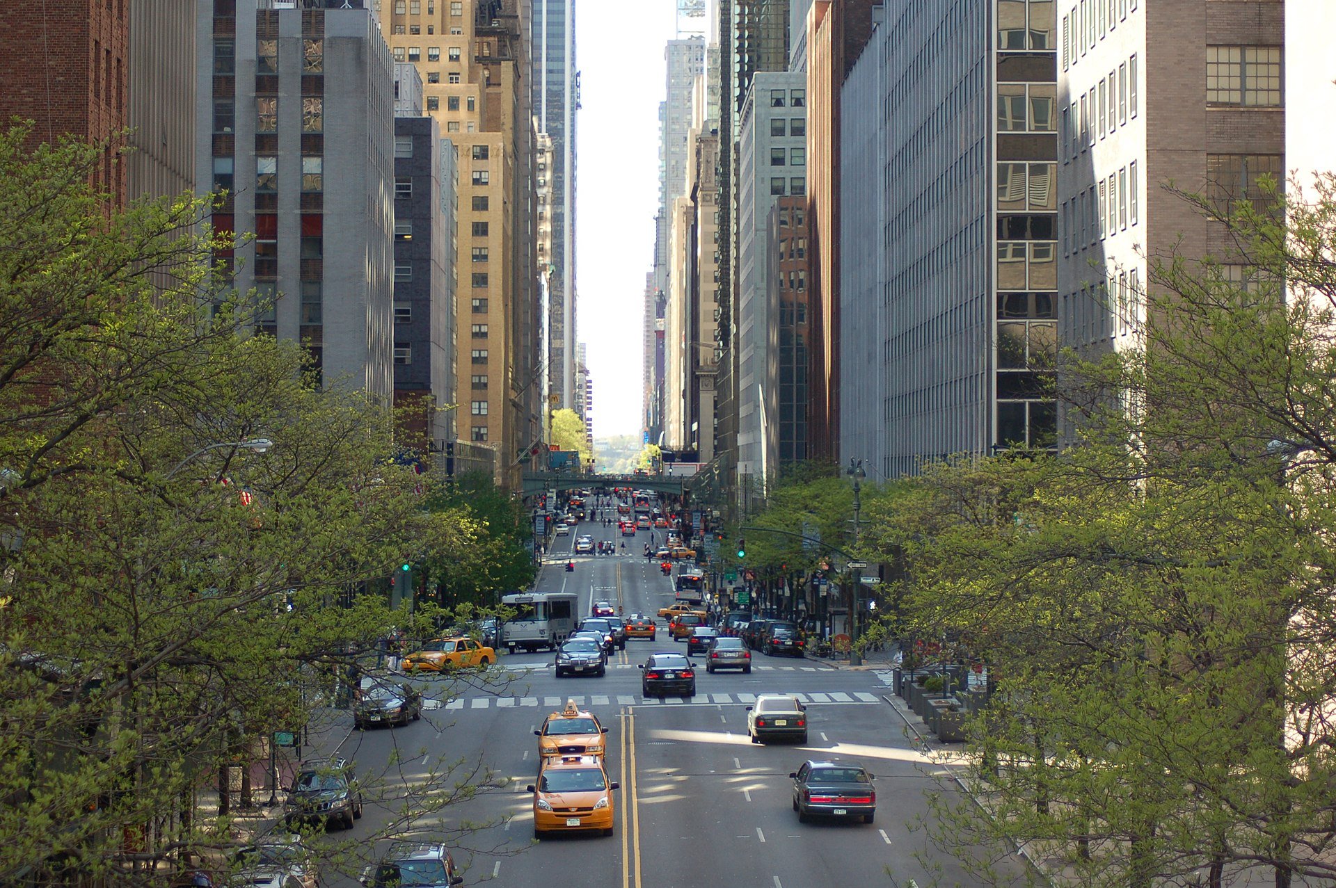
    VPS use computer vision to determine position relative to known landmarks. In favorable environments – especially dense, feature-rich urban settings — they can deliver impressive accuracy. VPS has been successfully applied in AR anchoring, pedestrian navigation, and even some indoor mapping, offering a level of precision that is difficult to match with GNSS alone.

    At the same time, VPS faces challenges that limit its ability to scale as a standalone universal solution. Maintaining vast libraries of reference imagery requires constant collection and refreshing, even for companies with resources such as Google’s Street View. Keeping cameras active and running neural network matching consumes power and compute, with AR and navigation apps often showing rapid battery drain when vision pipelines are engaged.

    Performance can also be fragile, with accuracy dropping in low light, bad weather, or environments with limited features such as open fields or glass-heavy corridors where reflections distort recognition. Because VPS requires continuous camera use, it also raises privacy concerns under regulations like GDPR.

    But VPS still fills an important feature set: it works best in exactly the environments where GNSS struggles most. In dense urban areas with abundant visual features but heavy multi-path interference, VPS provides a complementary capability that enhances overall localization performance when paired with GNSS+IMU.

    GNSS+IMU Fusion

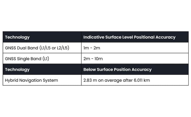
    GNSS provides global reach, but smartphone accuracy typically ranges from 3m to 5 m. This may be adequate for turn-by-turn navigation, but it does not meet the precision required for lane-level guidance, pedestrian navigation or building entrances. Pairing GNSS with IMU data changes that equation by adding orientation and motion context.

    Sensor fusion combines GNSS position (x, y, z) with IMU-derived orientation (α, β, γ) to deliver six degrees of freedom (6DoF). In practice, this allows devices to determine not only where they are, but also which way they are facing, which is critical for navigation and AR anchoring.

    Another key advantage is that fusion also runs efficiently on-device, using low-power sensors already embedded in nearly every phone. It avoids the battery drain and compute overhead of vision-based methods, remains resilient in poor visibility, and largely sidesteps the privacy concerns associated with continuous camera use.

    Together, GNSS+IMU and VPS offer complementary strengths: GNSS+IMU provides scalable global coverage, while VPS adds value in dense urban or visually rich environments. Used in tandem, they extend reliable sub-meter localization across a far wider range of real-world scenarios.

    Performance in Field Tests

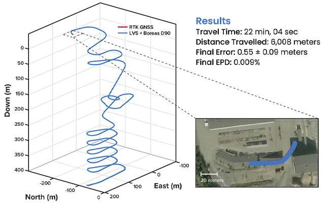
    Independent field testing has underscored the impact of GNSS+IMU fusion in real-world conditions. In trials conducted in Louisville, Colorado, standard smartphones relying solely on GNSS averaged ~1.9 meters of error. When collaborative corrections and IMU fusion were added, mean error dropped to ~0.55 meters – a more than threefold improvement.

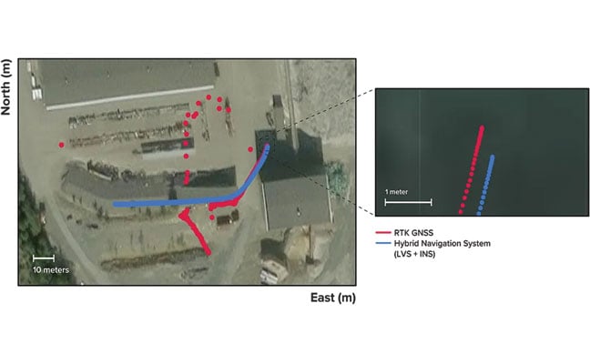
    To benchmark localization performance against visual methods, we compared heading determination from Zephr’s sensor-based approach with Google’s VPS, widely considered an industry leader in vision-based localization. Using the same device and location, headings generated from ArPose and Zephr were plotted against VPS outputs.

    Figure 1: The figure shows a strong correlation, with a mean heading difference of just 7.58• and a heading correlation of 99.52%.
    Figure 1: The figure shows a strong correlation, with a mean heading difference of just 7.58° and a heading correlation of 99.52%.

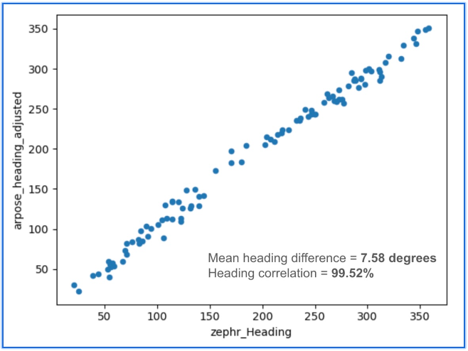
    The results in Figure 1 show a strong correlation, with a mean heading difference of just 7.58 degrees and a heading correlation of 99.52%. This provides a useful benchmark, illustrating that sensor-based approaches can achieve heading accuracy on par with vision-based systems while avoiding the data, compute, and privacy burdens tied to continuous camera use.

    Head-to-Head Comparison

    When considered side by side, VPS and GNSS+IMU reveal distinct strengths. VPS delivers high accuracy in dense urban environments, where GNSS can be degraded by multipath or blockage. GNSS+IMU, meanwhile, provides consistent global coverage and efficient performance in open environments where VPS has fewer features to recognize. Taken together, they form a complementary toolset, with each addressing the other’s gaps.

    • Cost & Infrastructure: VPS offers detailed visual positioning but requires continuous investment in capturing and updating reference imagery, which can run into petabytes of data and demand large-scale cloud storage. GNSS+IMU leverages existing satellite constellations and commodity sensors already embedded in smartphones, scaling naturally without additional infrastructure.
    • Battery & Compute: VPS enables precise landmark recognition but must keep cameras active and process high-resolution frames, a pipeline that consumes energy and compute. GNSS+IMU fuses lightweight sensor readings on-device, sustaining real-time performance with minimal power. Hybrid systems can use VPS selectively for visual anchors when power budgets allow.
    • Environmental Robustness: VPS excels in dense urban cores where landmarks are abundant, but its performance can degrade in low light, heavy weather, or feature-poor settings such as highways or open fields. GNSS+IMU continues to perform in most outdoor environments, with IMUs bridging short GNSS gaps in tunnels or urban canyons. Together, they extend reliable coverage across diverse conditions.
    • Privacy: VPS provides visual context but depends on continuous camera feeds, which can raise concerns under regulations like GDPR and CCPA. GNSS+IMU relies solely on inertial and satellite data, which can be anonymized and processed on-device. Privacy-conscious applications may favor GNSS+IMU as the default, while invoking VPS in controlled contexts.
    • Scalability: VPS delivers strong results in mapped geographies but is constrained by the cost of collecting and maintaining visual data globally. GNSS+IMU scales as more devices ship with standard GNSS receivers and inertial sensors, with accuracy improving further when devices contribute corrections to a shared network. In combination, VPS can add value in high-density urban corridors where visual richness offsets its infrastructure demands.

    Beyond Accuracy: Spatial Intelligence Without Cameras

    GNSS+IMU fusion not only narrows positioning error but also provides contextual awareness. By combining positional vectors with device orientation, systems can determine not just where a device is, but what lies within its field of view.

    This contextual layer enables landmark-aware navigation and natural AI interactions. Instead of vague coordinates, users could be guided to “meet at the blue mailbox next to the coffee shop entrance.” In AR, digital content can be anchored to the physical world without the overhead of vision-based methods. And for AI interfaces, assistants could answer spatial queries (“Is the restaurant to my right or left?”) with precision that feels intuitive.

    While GNSS+IMU avoids reliance on cameras, VPS can still add complementary value by providing visual anchors in feature-rich spaces. Used together, the two methods create a more resilient and adaptive localization system, able to support a wider range of real-world scenarios than either could alone.

    A Clearer Path Forward

    VPS has proven valuable in research, robotics, and AR demonstrations, particularly in dense urban environments. But its reliance on imagery, heavy compute, and continuous camera use makes it difficult to scale as a universal solution for sub-meter accuracy.

    To unlock the next generation of spatially intelligent applications, from context-aware assistants to immersive AR, localization must be both practical and massively scalable. This foundation will come from GNSS+IMU sensor fusion, complemented by vision-based methods where they add value. GNSS+IMU builds on infrastructure and sensors already present in billions of devices, delivers efficient on-device performance, and avoids the privacy tradeoffs of camera-based systems.

    As positioning becomes the backbone of spatial AI, the evidence points to a decisive outcome: the future will be multimodal, but the scalable backbone will be GNSS+IMU fusion since it empowers devices to understand and interact with the world reliably, with or without cameras.

  • SimCom’s GNSS modules now integrated with Swift’s Skylark service

    SimCom’s GNSS modules now integrated with Swift’s Skylark service

    Swift Navigation and SimCom are partnering to deliver centimeter-level GNSS accuracy to high-volume robotics applications worldwide. The collaboration integrates Swift’s Skylark precise positioning service with SIMCom’s high-performance SIM66MD and SIM66D GNSS modules.

    This combination allows manufacturers and developers using these modules to activate centimeter-accurate satellite positioning, dramatically improving the performance, safety and reliability of robotic lawnmowers, delivery robots, agricultural vehicles, and other autonomous systems. SIMCom’s GNSS modules have compact designs, low power consumption, and wide array of interfaces, making them suitable for seamless integration into diverse IoT and autonomous devices.

    Swift’s Skylark Nx RTK, the highest precision variant of Skylark, leverages a proprietary atmospheric model to deliver continuous 1-2 cm accuracy across vast geographic areas, including all of Western Europe. The carrier-grade network eliminates the need for developers to manage base stations or switch between multiple correction providers, simplifying deployment of high-precision outdoor robots at scale.

    Key benefits for autonomous navigation:

    • Autonomous Operation. Centimeter-level accuracy is essential for robots to execute complex tasks, such as following precise mowing patterns, planting seeds with exact spacing, or navigating narrow construction sites.
    • Safety and Geofencing. Precise localization enables reliable enforcement of virtual boundaries (geofencing), preventing robots from entering restricted zones or colliding with obstacles, which is critical for safety in public or shared spaces.
    • Improved Efficiency. Reliable 1-2 cm precision reduces path errors, minimizes overlap in coverage (e.g., in farming or lawn care), and ensures the robot consistently reaches its exact target destination, maximizing battery life and operational uptime.

    Customers purchasing SIMCom’s SIM66MD and SIM66D modules now receive a six-month free trial of Skylark Nx RTK.

  • Safran’s Skydel NAVWAR strengthens national defense and airspace sovereignty

    Safran’s Skydel NAVWAR strengthens national defense and airspace sovereignty

    Safran Electronics & Defense had unveiled Skydel NAVWAR, a software solution designed to protect against hostile UAVs by disrupting their navigation systems.

    As the core of Safran’s counter-UAV (C-UAV) systems, Skydel NAVWAR disrupts UAV navigation by simulating authentic GNSS signals, providing nations and organizations with advanced protection for their most critical assets.

    Skydel NAVWAR can be deployed on tactical platforms and integrated with sensors and command-and-control systems, allowing operators to conduct remote spoofing operations without being physically present at the target location.

    “Protecting national sovereignty requires more than just technology — it demands trusted systems that empower countries to take control of their own security,” said Maxime Gorlier, director of positioning, navigation and timing at Safran Electronics & Defense. “With Skydel NAVWAR, we are giving our partners the capability to safeguard their airspace, defend critical infrastructure and ensure resilience in the face of evolving threats.”

    The system features a secure application programming interface, hardened operating system and field-tested durability designed for demanding operational conditions. It supports all major global navigation satellite systems, including GPS, Galileo, GLONASS, BeiDou, NavIC, QZSS and space-based augmentation systems, as well as emerging low-Earth orbit (LEO) signals.

    The software can simulate thousands of satellites in real time using commercial off-the-shelf hardware and operates at a 1,000 Hz iteration rate.

    Safran designed the system to enable defense integrators to build sovereign anti-drone capabilities, enhancing national autonomy in countering UAV threats.

  • MediaTek, China Telecom and Xiaomi bring RTK positioning to urban environment

    MediaTek, China Telecom and Xiaomi bring RTK positioning to urban environment

    MediaTek, China Telecom and Xiaomi have announced an upgrade to its real-time kinematic (RTK) high-precision positioning technology. The joint development integrates 5G connectivity, advanced chip design and Xiaomi’s smart technology.

    RTK technology is usually found in professional surveying tools, but will now be available for location and positioning in smartphones, cars and city networks, according to the companies.

    The newly upgraded RTK system enables outdoor positioning with sub-meter accuracy and fast response times. Leveraging 5G network infrastructure, smart data transmission, and close chipset-mobile software coordination, the system could be widely implemented on smart city infrastructure, autonomous driving, and smart transportation.

    This partnership is part of Xiaomi’s growth beyond smartphones into urban development and smart mobility technologies under the Xiaomi HyperConnect banner.

    The improved collaboration between MediaTek’s cutting-edge chipsets, China Telecom’s network, and Xiaomi’s hardware-software ecosystem enables an optimized RTK performance model that can potentially redefine how smart devices interact in real-world environments.

  • Trimble Applanix: Delivering on the ‘Last Meter’

    Trimble Applanix: Delivering on the ‘Last Meter’

    The demand for autonomy is accelerating across  industries, reshaping how systems are being developed and deployed. 

    For UAVs, the push for precision is driven by emerging use cases, such as package delivery, medical transport and complex route navigation in urban environments, all of which require centimeter-level accuracy in positioning and landing. 

    Importance of Correction Services 

    Trimble is expanding its Centerpoint RTX positioning technology from agriculture and surveying applications into the rapidly growing autonomous markets of UAVs, robotics and vehicles. 

    CenterPoint RTX is a global correction service that delivers centimeter-level positioning accuracy, engineered to ensure reliable and precise positioning anywhere around the world. 

    RTX employs a fixed, stable datum to ensure consistent and reliable performance. The system supports all major satellite constellations and frequencies, offering users a robust and flexible positioning system. The service can be accessed through either L-band satellite signals or a standard internet connection, eliminating the need for local base stations and making high-precision positioning far more scalable and accessible.

    This level of reliability is crucial for emerging applications such as drone delivery. 

    “When you start talking about package delivery, operators need robust positioning,” explained Joe Hutton, director of inertial technology and airborne products at Trimble Applanix. “One reason is what we call ‘the last meter’ — drones need to be able to land or drop packages consistently within that final meter of their destination.” 

    Hutton noted that precision requirements are becoming even more demanding. “It’s actually getting smaller than a meter now. You need that robust centimeter-level positioning to ensure the drone is in exactly the right spot for safe and accurate delivery.”

    When asked about alternative positioning methods, Hutton explained why traditional RTK systems can fall short for these applications. “RTK has its traditional limitations,” he said. “You have to be within 20 km of a base station, you need to set up infrastructure, and then you face all kinds of datum issues between different base stations.”

    This is where CenterPoint RTX offers a significant advantage. “You don’t get those problems with CenterPoint RTX because it’s a global correction service operating on a fixed reference datum that never changes,” Hutton explained. “If you use the same technology to survey your landing spot — say with a Trimble DA2 product using RTX — everything fits perfectly. It’s always going to be in the same datum.” He noted that this consistency has proven very popular with users because it eliminates the complex datum coordination issues inherent in RTK systems.

    Beyond datum consistency, Hutton highlighted another critical consideration: signal robustness and jamming and spoofing. “While commercial drone applications typically operate outside conflict zones where intentional jamming occurs, operators still need protection against interference,” he said. “You can have radios causing jamming just inadvertently.”

    Trimble’s OEM GNSS/INS systems for UAV navigation, such as Trimble PX-1, use aided inertial navigation system (INS) software that blends GPS positioning with inertial sensors using RTX corrections to offer robust position and orientation data — including precise roll, pitch and heading measurements — that can maintain accuracy even during short GNSS signal outages. 

    The system provides inertial-based heading, which addresses another critical challenge in drone navigation. Traditional approaches rely on magnetometers for heading determination, but these are easily influenced by nearby metal structures and electromagnetic interference. In contrast, inertial-derived heading comes directly from the IMU itself, making it immune to magnetic disturbances and far more reliable in complex environments, making it suitable for drone delivery in busy urban environments. 

  • Advanced Navigation Conquers Europe’s Deepest Underground Mine

    Advanced Navigation Conquers Europe’s Deepest Underground Mine

    Advanced Navigation has successfully demonstrated a breakthrough in underground navigation, delivering high-precision positioning without reliance on fixed infrastructure or GNSS.

    The demonstration of the company’s Hybrid Navigation System was livestreamed from the Pyhäsalmi Mine in Pyhäjärvi, Finland, as part of the Deep Mining Open Call under the Think and Act Differently program sponsored by BHP, an Australian mining and metals corporation. 

    The Deep Mining Open Call, launched in September 2024, sought innovators with capability that could be applied to deep underground mining. The focus was on addressing challenges such as high temperature, high rock stress, and hyper-saline conditions in deep mining environments. The inactive Pyhäsalmi mine has the harsh conditions and depth required for the technology test.

    Based in Australia, Advanced Navigation was selected from more than 90 global applicants to demonstrate its technology.

    Positioning Challenges

    Navigating the vast subterranean network of the Pyhäsalmi Mine posed significant challenges. The mine is situated just two degrees below the Arctic Circle, where traditional systems fail. Located 1.4 km underground at a latitude of 63°, it is completely impervious to GNSS signals. Its repetitive, multi-level tunnel network creates a high risk of visual disorientation, while its metallic ores distort magnetic fields and scatter radio waves.

    To overcome these conditions, mines typically rely on infrastructure-heavy solutions such as ultra-wideband beacons, Wi-Fi, 5G repeaters or perception-based techniques such as simultaneous localization and mapping (SLAM), which require cameras. These methods are costly to integrate and maintain, slow to install, and often unavailable in hazardous or unmapped zones where reliable navigation is critical. Shifting to a resilient navigation system with less dependency on infrastructure offers a scalable alternative, enabling reliable navigation even in environments considered hazardous or inaccessible.

    System Architecture

    Advanced Navigation’s Hybrid Navigation System demonstrates long-range, infrastructure-free, real-time navigation in a deep, GPS-denied environment. The system combines a laser velocity sensor (LVS) with the Boreas D90 fiber-optic gyroscope inertial navigation system (FOG INS).  

    FOG INS. The Hybrid Navigation System is centered on the Boreas FOG INS. Unlike conventional systems, Boreas doesn’t rely on GNSS or magnetic compasses. Instead, it uses ultra-sensitive FOG technology to detect the Earth’s rotation and determine true north, a process known as gyro-compassing, to find the vehicle’s heading.

    For the test, the Boreas D90, along with various additional equipment providing power, networking and logging capabilities, was secured inside the vehicle.

    LVS. To maintain and enhance this accuracy, the INS is fused with Advanced Navigation’s LVS. Using infrared lasers, LVS continuously measures the vehicle’s true 3D velocity relative to the ground. This real-time data is critical for correcting the gradual drift that occurs in standalone inertial systems, enabling the hybrid system to maintain precision over extended distances.

    The LVS sensor features two components: an external, passive optical head, and an active sensor body. The optical head is primarily responsible for rigidly holding the alignment between the three telescopes. The sensor body houses the active photonics system, laser and processing system.

    Because pre-production hardware was used for this test, three discrete fiber-optic cables were used to connect the externally mounted LVS optical head to the LVS sensor inside the vehicle. Production hardware will include a single, IP69K rated optical-fiber cable that connects the LVS sensor body to the IP69K rated optical head.

    The LVS optical head was attached to the trunk of the vehicle using a suction cup to provide a clear line of sight from each telescope to the terrain. A GNSS antenna was attached to the roof in the same manner. Coaxial cable connected the GNSS antenna to the Boreas D90.

    Fusion Software. The system integration relied on the company’s AdNav OS Fusion software. Using adaptive algorithms, OS Fusion dynamically weighs the reliability of each sensor in real time.

    Together, these technologies form a resilient hybrid system delivering precise, uninterrupted navigational data in extreme environments, without GNSS or fixed infrastructure, the company said.

    “We were thoroughly impressed by the results the sensor fusion provided,” said Magnus Zetterberg, senior consultant at Combitech, who observed the demonstration. “I have used and been exposed to these sorts of sensors in other projects, and nothing has come close to this level of performance. It’s clear the Laser Velocity Sensor is a major key in providing these outstanding results.”

    Proven in the Depths

    A one-time surface calibration using real-time kinematic GNSS aligned the LVS and INS frames on the vehicle, a Mercedes-Benz V-class. After the calibration, the trials were unaided within the underground environment.

    Two different test scenarios were conducted: a surface-to-surface test, and an underground loop test. Validated across five separate runs in isolation from external aids or maps, the Hybrid Navigation System repeatedly achieved an accuracy of better than 0.1% of distance traveled — demolishing a barrier once considered fundamental to underground navigation.

    Without relying on any fixed positioning infrastructure, pre-existing maps or external aiding, the tests achieved consistent sub-0.1% navigation error across multiple runs.

    Surface-to-Surface Runs

    Runs 1, 2 and 3 – 400 m. To demonstrate the system’s repeatability and accuracy, three identical runs were conducted to a depth of 400 meters. Each run involved an approximate 3 km one-way traverse for a full 6 km loop. The results highlight the system’s consistent performance during underground operation, with a mean final position error of 2.83 ±0.09 meters, representing 0.047% of the total distance traveled.

    Photo: FIGURE 1  3D navigation trace of run 2 of the repeat surface-to-surface 400 m depth tests. This particular run covered 6,008 m, with a measured error of 0.55 ±0.09 m for 0.009% error per distance traveled.
    FIGURE 1 3D navigation trace of run 2 of the repeat surface-to-surface 400 m depth tests. This particular run covered 6,008 m, with a measured error of 0.55 ±0.09 m for 0.009% error per distance traveled.

    Over the 6 km rough and rugged terrain that extended 400 m below the surface, the system achieved a best-case 3D position error of 0.55 m (0.009%), with an average error of 2.83 m (0.047%). For context, standard single-band GNSS on the surface typically delivers 2–10 m accuracy in open-sky conditions. The system delivered significantly greater precision even within a subterranean labyrinth. FIGURE 1 present the key performance metrics for these runs. FIGURE 2 shows reacquisition of GNSS signals upon exiting the mine.

    FIGURE 2  Traces of raw RTK GNSS and position estimates from the Hybrid Navigation System. As the vehicle exits the tunnel portal, intermittent and low accuracy GNSS is measured. Once the vehicle enters open sky, a more consistent RTK GNSS fix is attained. Note that despite the presence of now-accurate RTK GNSS, at no point did the Hybrid System use GNSS information.
    FIGURE 2 Traces of raw RTK GNSS and position estimates from the Hybrid Navigation System. As the vehicle exits the tunnel portal, intermittent and low accuracy GNSS is measured. Once the vehicle enters open sky, a more consistent RTK GNSS fix is attained. Note that despite the presence of now-accurate RTK GNSS, at no point did the Hybrid System use GNSS information.

    “We’ve worked in underground environments for decades. Seeing this level of precision achieved on the first run signals huge potential for safer and more efficient underground vehicle operations,” said Olli Mylläri, vice president of technology at Normet, a mining technology company.

    Run 4 – 1,400 m. To evaluate the system’s performance over an extended distance, a single run was conducted to the deepest accessible point of the mine, reaching a depth of 1,400 m. The system navigated the 22.9 km route — the equivalent of a half-marathon — in total darkness.

    The final position error was 15.9 m (0.07%), showcasing its immunity to the drift that plagues other inertial systems. This extended traverse, lasting more than 94 minutes, also included a deliberate stationary period at the bottom before the return to the surface. The performance of this deep run is detailed in FIGURE 3.

    FIGURE 3  3D navigation trace of the run down to 1,400 m depth. The test traversed a total distance of 22,920 m, with a measured final error of 15.98 ±0.09 m yielding an error per distance traveled of 0.070%. The descent and ascent paths are colored differently for disambiguation. During the ascent (light blue), the driver entered a side tunnel at a depth of approximately 1,200 m, which was not traversed on the descent.
    FIGURE 3 3D navigation trace of the run down to 1,400 m depth. The test traversed a total distance of 22,920 m, with a measured final error of 15.98 ±0.09 m yielding an error per distance traveled of 0.070%. The descent and ascent paths are colored differently for disambiguation. During the ascent (light blue), the driver entered a side tunnel at a depth of approximately 1,200 m, which was not traversed on the descent.

    Entirely Underground

    Run 5 – 1,067 m. A single run of 1,067 m was conducted over a period of 14 minutes. Without relying on magnetometers or external aids, the system determined heading using its built-in gyrocompassing procedure, measuring the Earth’s rotation to establish true north. It then navigated a 1 km course with just 1 meter of error, demonstrating its capability for rapid deployment in the most challenging and unfamiliar terrain. See results in FIGURE 4.

    FIGURE 4  3D navigation trace of the entirely underground run. The test traversed a total distance of 
1,067 m, with a measured final error of 1.03 ±0.02 m, yielding an error per distance traveled of 0.093%.
    FIGURE 4 3D navigation trace of the entirely underground run. The test traversed a total distance of
    1,067 m, with a measured final error of 1.03 ±0.02 m, yielding an error per distance traveled of 0.093%.

    While additional testing was planned to further validate the results, time constraints limited this study to a single test. The findings provide a representative indication of system performance under the tested conditions. TABLE 1 shows a comparison to GNSS navigation.

    TABLE 1  Indicative industry-reported positional accuracy of GNSS compared to the Hybrid Navigation System.
    TABLE 1 Indicative industry-reported positional accuracy of GNSS compared to the Hybrid Navigation System.

    Scalable Autonomy

    While mines will continue to use fixed infrastructure, this technology significantly reduces dependency, enabling resilient, high-precision navigation in previously inaccessible or unmapped areas. This performance marks a step change in underground navigation, unlocking new potential for fleet management, predictive collision avoidance, material tracking and scalable autonomy across mining operations.

    “At Normet, we specialize in advanced solutions for underground mining and tunneling, so we know firsthand how difficult accurate and reliable navigation can be in these environments,” Mylläri said. “Seeing Advanced Navigation’s Hybrid Navigation System deliver consistent positioning with minimal infrastructure deep within the Pyhäsalmi Mine was remarkable. It’s a powerful step forward for automation and safety in the underground space.”

    In today’s dynamic operational environments, relying on a single navigation technology is no longer viable. Robust navigation demands a layered, inertial-first and multi-sensor architecture — held together by intelligent software — that can adapt and scale to meet the unique demands of each operation.

    “Ultimately, this vehicle-based, inertial-centered architecture provides the resilient foundation required for the mining sector to achieve its long-term goal: efficient autonomous ore extraction at depths hostile to human activity,” Vandecar said.

    “Unreliable navigation underground isn’t a minor technical constraint — it’s a major operational bottleneck,” said Joe Vandecar, senior product manager, Advanced Navigation. “Maintaining precision over a 22.9 km subterranean course in Europe’s deepest underground mine demonstrates a level of performance that few systems in the world can rival without any prior intelligence of the environment. These results prove we’re one step closer to unlocking scalable underground autonomy.”

    The Hybrid Navigation System is set for commercial release later this year. 

    Adapted from a paper authored by Patrick Wiltshire, David McManus, James Spollard, Mark Gibson, Matthew Suntup, Tim Laws and Lyle Roberts. The full paper is available on the Advanced Navigation website (advancednavigation.com).

  • Vatn Systems unveils inertial navigation system for maritime applications

    Vatn Systems unveils inertial navigation system for maritime applications

    Vatn Systems has released INStinct, an inertial navigation system (INS) designed to provide GPS-free navigation for maritime operations.

    The defense technology company, which manufactures autonomous underwater vehicles (AUVs) for the U.S. military and commercial clients, said the system uses technology from ANELLO Photonics to deliver navigation capabilities in GPS-denied environments at lower cost than existing systems.

    The system features a modular design that allows users to configure it based on mission requirements. It can be equipped with various inertial measurement units, including ANELLO’s X3 IMU, which uses Silicon Photonics Optical Gyroscope technology. The X3 IMU is designed to withstand shock and vibration in maritime conditions.

    “Inertial navigation is the cornerstone of autonomy at sea,” said Nelson Mills, CEO and co-founder of Vatn Systems. “With INStinct, we’ve created a navigation solution that meets the needs of both our own vehicles and third-party platforms, offering reliability, accuracy, and adaptability. ANELLO’s IMU technology allows us to offer an INS with FOG performance at a fraction of the traditional cost. The launch of INStinct marks another milestone in our broader strategy to own the full tech stack for underwater vehicles.”

    “The integration of our technology and our ANELLO X3 IMU into Vatn’s platforms and INS marks a pivotal advancement in our mission to transform autonomous underwater navigation,” said Dr. Mario Paniccia, CEO and co-founder of ANELLO Photonics.”Our technology has been rigorously field-tested across land, air, and sea environments, and we are thrilled to collaborate with Vatn to offer an underwater navigation solution. This partnership highlights our commitment to delivering next-generation navigation solutions that empower accurate and more efficient underwater operations.”

    The system supports integration with Doppler velocity logs and includes maritime-specific algorithms. Housing configurations range from original equipment manufacturer specifications to depth-rated enclosures.

    Vatn Systems said it plans to deliver vehicles equipped with INStinct to customers by the end of 2025.

  • UAV Navigation-Grupo Oesía integrates Iridium terminal into flight control system

    UAV Navigation-Grupo Oesía integrates Iridium terminal into flight control system

    UAV Navigation-Grupo Oesía, a developer of flight control systems for UAVs, has completed integration and validation of ATMOSPHERE’s Iridium terminal into its VECTOR family of flight control computers. The integration was tested in flight conditions.

    ATMOSPHERE’s Iridium terminal has been integrated into UAV Navigation-Grupo Oesía’s flight control system via RS-232 serial communication. The integration enables command and control beyond visual line of sight.

    During flight tests, the communication link remained stable, with telemetry performance comparable to traditional radio systems.

    The guidance, navigation and control system allows autonomous operation without requiring a control station link during flight. The integration supports two-way communication for mission updates and re-tasking. UAV Navigation-Grupo Oesía said the integration expands options for beyond visual line of sight operations.

    The integration is part of the company’s effort to enhance operational capabilities for its clients. The system’s interoperability has been expanded to work with additional communication infrastructures and mission profiles. Iridium’s global coverage and low-latency service enable operators to maintain control of platforms in remote areas, over oceans or in environments where radio links may be unavailable.

    The development applies to defense, security and industrial applications where beyond visual line of sight (BVLOS) operations require reliable communication. UAV Navigation-Grupo Oesía provides autonomous flight solutions.

  • Closing the urban canyon: Why improving GNSS reliability will be vital for autonomous cars

    Closing the urban canyon: Why improving GNSS reliability will be vital for autonomous cars

    Content provided by Focal Point Positioning

    The term “urban canyon” was inspired by New York’s Canyon of Heroes — a stretch of Lower Broadway where tall buildings line the streets similar to a canyoenn. These human-built canyons can confuse GNSS receivers making it hard to accurately calculate a vehicle’s position. For autonomous cars, that’s not just inconvenient — it’s a major safety issue. However, with the right technology, the automotive world can “close’” these urban canyons, explains Manuel Del Castillo, vice president of business development at Focal Point Positioning.

    On open roads with a clear view of the sky, satellite navigation can be remarkably accurate. Signals from multiple GNSS constellations reach the vehicle’s receiver unimpeded, helping calculate position with impressive accuracy. However, this often isn’t the case in dense urban areas.

    Tall glass buildings, narrow streets, concrete bridges and overpasses all form urban canyons — and can be a barrier to even the most sophisticated navigation systems.

    The Challenge

    In cities and other urban environments, there are two common challenges for GNSS performance. The first is multipath interference, which occurs when signals bounce off buildings, glass façades and even parked cars before reaching the receiver. Rather than receiving one clean signal from the satellite, the receiver gets a clean signal and several delayed copies, leading to erroneous positioning estimates.

    Signal occlusion is another issue, which occurs when tall buildings and structures physically block some satellite signals from view. The signals that are actually received from that satellite are reflections. This makes it difficult for the receiver to lock onto a stable fix.

    In practice, both issues can cause sudden anomalies — enough to place a car on the wrong street entirely. For drivers, this is frustrating. For autonomous systems, it’s a safety risk.

    The Road to Autonomy

    Urban GNSS challenges aren’t new — taxi drivers in London and New York have long experienced their navigation systems getting “lost” among the towers. However, positioning accuracy is now more important than ever as automotive technology evolves and we hand over more control to our vehicles.

    Advanced driver assistance systems (ADAS) are now pushing the limits of conventional GNSS. Features such as lane-keeping, automated lane changes and intelligent speed adaptation all rely on knowing the vehicle’s exact position – not just the road it’s on, but which lane.

    As we move further towards autonomous driving, the stakes will be even higher. If GNSS references are unreliable, this could cause serious errors on the road. A sudden position jump in the middle of a complex urban manoeuvre is more than inconvenient — it’s dangerous.

    Closing the Canyon

    If autonomous cars are to drive safely and reliably in urban environments, GNSS must evolve. The answer lies in rethinking how satellite signals are processed — and in tackling the root causes of error. Traditional receivers rely heavily on hardware-based processing, meaning they integrate new technologies at a slow pace.

    To help overcome this challenge, we developed S-GNSS Auto — software that enhances GNSS receiver reliability and accuracy in autonomous vehicles. Delivered as a simple firmware upgrade, it transforms GNSS into a more powerful component of the ADAS stack in areas where traditional solutions fall short. 

    We recently integrated S-GNSS Auto onto STMicroelectronics’ Teseo GNSS devices, and tested the impact of the joint solution in some of the most challenging urban environments: Shinjuku in Tokyo, and Frankfurt and the Black Forest in Germany. The combined solution demonstrated an improvement in measurement accuracy by up to four times and position accuracy by up to three times in the challenging sections of these environments. By ignoring reflected or non-line-of-sight signals, S-GNSS Auto can also reject potential spoofing attacks, enhancing the security of the GNSS receiver.

    McKinsey reports that 12% to 20% of cars could have advanced autonomous driving capabilities by 2030. For automakers, this means expanding the roads and environments that can safely support these capabilities. S-GNSS® Auto helps make that possible by improving GNSS reliability and laying the foundation for advanced vehicle-to-everything (V2X) and ADAS technologies needed to support autonomous vehicle safety in challenging urban areas. Working directly from the chip, it provides a cost-effective and accessible way for automotive OEMs to upgrade their technology via a firmware upgrade.

    To see the impact of the integrated S-GNSS Auto and Teseo solution, download the latest data from our trials in Japan and Germany here.


    This article is contributed by Focal Point Positioning.

  • SmartNav makes GPS ultra-precise, even in tough urban canyons

    SmartNav makes GPS ultra-precise, even in tough urban canyons

    NTNU researchers have built SmartNav, a system that overcomes urban GPS errors using satellite corrections and Google’s 3D data. It achieves near-centimeter precision, paving the way for safer, more reliable self-driving cars. 

    Researchers at the Norwegian University of Science and Technology (NTNU) have created SmartNav, combining satellite corrections, wave analysis, and Google’s 3D building data for remarkable precision. Their method achieved accuracy within 10 centimeters during testing, and could make reliable urban navigation accessible and affordable worldwide, including autonomous vehicles.

    The paper is published in the Journal of Spaial Sciences, DOI: 10.1080/14498596.2025.2536567.

    “Cities are brutal for satellite navigation,” explained Ardeshir Mohamadi. “In cities, glass and concrete make satellite signals bounce back and forth. Tall buildings block the view, and what works perfectly on an open motorway is not so good when you enter a built-up area.”

    Mohamadi, a doctoral fellow at NTNU, is researching how to make affordable GPS receivers much more precise without depending on expensive external correction services. “For autonomous vehicles, this makes the difference between confident, safe behavior and hesitant, unreliable driving. That is why we developed SmartNav, a type of positioning technology designed for urban canyons,” Mohamadi said.

    To solve this problem, the researchers combined several technologies to correct GPS signals, resulting in a computer program that can be integrated into the navigation system of autonomous vehicles. The software developed by the researches uses PPP-RTK (precise point positioning – real-time kinematic), which combines precise corrections with satellite signals. The European Galileo system now supports this by broadcasting its corrections free of charge.

    An assist from Google

    Meanwhile, Google launched a new service for its Android customers that provides 3D models of buildings in almost 4,000 cities around the world. The company is using these models to predict how satellite signals will be reflected between the buildings, allowing users to see if they are walking on the correct side of he street.

    The researchers were able to combine all these different correction systems with algorithms they had developed. When they tested it in the streets of Trondheim, they achieved an accuracy better than 10 centimeters 90 percent of the time.

    The use of PPP-RTK will also make the technology accessible to the general public because it is a relatively affordable service.

    “PPP-RTK reduces the need for dense networks of local base stations and expensive subscriptions, enabling cheap, large-scale implementation on mass-market receivers,” Mohamadi said.

  • Trimble unveils mobile mapping systems for land and air applications

    Trimble unveils mobile mapping systems for land and air applications

    Trimble has released two positioning system portfolios for mobile mapping and direct georeferencing — Applanix POS LVX+ and Applanix POS AVX RTX — designed to meet evolving demands in the geospatial industry. The solutions are designed to deliver improved accuracy and efficiency for land-based and airborne mobile mapping applications.

    Trimble is showcasing both portfolios at Intergeo 2025, alongside Applanix POSPac Complete advanced post-processing software introduced last week.

    Both portfolios include a one-year subscription to the Trimble CenterPoint RTX correction service and Applanix POSPac Complete for desktop and cloud, which includes post-processed CenterPoint RTX. By integrating real-time and post-processed data, users can achieve global coverage without traditional GNSS base stations, avoiding complications from base stations in different local datums or epochs. Both systems achieve centimeter-level accuracy and support Trimble IonoGuard technology for advanced mitigation against ionospheric disruptions.

    “By bundling both real-time and post-processed RTX into the POS LVX+ land and POS AVX RTX air solutions for mobile mapping, these ready-to-use systems simplify procurement and enable immediate deployment,” said Steve Woolven, president and general manager of Applanix at Trimble. “These portfolios enable our customers to tackle the most complex mapping projects and ensure optimal accuracy for final deliverables.”

    Land-Based Systems

    The POS LVX+ portfolio offers six models with several key features: a smaller, lighter and more cost-effective design with rugged components suitable for diverse users and project types; the Applanix IN-Fusion+ multi-sensor aided inertial engine that maintains performance in challenging environments like urban canyons or tree canopy; suitability for projects using lidar sensors or cameras, plus fleet management and automotive applications; and onboard and external inertial measurement units that enhance reliability and performance.

    Airborne Positioning

    The Applanix POS AVX RTX portfolio includes four variants for mapping at different flying heights through improved orientation accuracy. Key features include over-the-air correction technology achieving positioning, velocity and orientation accuracy up to 0.03 horizontal meters root mean square (RMS) and 0.06 vertical meters RMS without additional setup or infrastructure; robust hardware with advanced inertial measurement units (IMU) and FAA-certified antenna and cabling; and combined real-time and post-processed RTX correction data for time-critical missions, large-scale corridor mapping and projects in remote or inaccessible areas.

    Availability

    The POS LVX+ and POS AVX RTX will be available in the first quarter of 2026 through Trimble Applanix sales channels. After the initial 12-month period, customers can purchase CenterPoint RTX license renewals and POSPac Complete term licenses. For more information or to request a demo, visit https://applanix.trimble.com/en/products/hardware/applanix-avx-rtx or https://applanix.trimble.com/en/products/hardware/applanix-pos-lvx+.

  • Unmanned systems updates: Government shutdown risks, UAS advances and eVTOL industry challenges

    Unmanned systems updates: Government shutdown risks, UAS advances and eVTOL industry challenges

    To echo the Association for Uncrewed Vehicle Systems International’s (AUVSI) pleas to Congress, a prolonged government shutdown could impact recent efforts to establish stronger counter-UAS protection for sensitive establishments across the U.S. and forestall key Federal Aviation Administration (FAA) hiring plans to support safe drone integration into the U.S. National Airspace System.

    Nothing is good about having roughly 750,000 people out of work and stalling their buying contributions to the American economy, not to mention that air traffic controllers, Border Patrol agents and other essential services are still working without pay. Hopefully common sense will prevail and the government will reopen soon.


    Originally known as the Boeing Airpower Teaming System or “Loyal Wingman,” the Boeing Australia MQ-28A Collaborative Combat Aircraft has been rechristened. Developed jointly by Boeing and the Royal Australian Air Force, the MQ-28A was not entered in the U.S. CCA competition and has remained fully employed in Australia with its team. Now referred to as the “Ghost Bat” — a name inspired by a north Australian flying bat by the same name, which uses “multi-spectral sensors” to hunt and learn in packs together — the name is a fitting analogy for the anticipated role of the MQ-28A.

    Ghost Bat taxies at RAAF base Woomera in Australia. (Credit: Beoing)
    Ghost Bat taxies at RAAF base Woomera in Australia. (Credit: Beoing)

    Flying since February 2021, the Ghost Bat has made significant steps toward operational readiness. Using AI-powered intelligence to perform autonomously, Ghost Bat has a replaceable nose section, each fitted with different sensor suites appropriate for different missions.

    With eight vehicles now available for a comprehensive operational verification test, in June and four months ahead of schedule, Ghost Bat completed a series of flights at both Woomera and Tindal bases in northern Australia. Capabilities demonstrated included autonomous missions, multi-ship operations and teaming with an E-7A Wedgetail early warning aircraft — including data fusion between multiple MQ-28A Ghost Bat aircraft and the crewed Wedgetail. The aircraft has flown for 150 hours and has accomplished more than 20,000 hours of virtual and ground testing. Able to find, fix, track and target, MQ-28A has proven its capability to carry out essential pieces of the air combat role — remaining elements include engage and assess, which will involve carrying air-to-air missiles later in 2025.

    This apparently brings the Boeing MQ-28A close to operational capability and ready for volume manufacturing. The eight aircraft have been built at an automated manufacturing facility in Melbourne, where two improved versions are currently being built that incorporate improvements developed through the testing phase, and a combined GPS/INS system will replace the commercial GPS on the aircraft. Ground has meanwhile been broken on a 100,000-square-foot high-volume manufacturing plant in the Wellcamp Aerospace and Defence Precinct in Queensland — expected to be complete within three years.


    While electric vertical take-off and landing (eVTOL) air-taxis under development progress towards certification by FAA and other agencies, introductory trials are also underway and agreements for future collaboration are being made all over around the world. While major players such as airlines and manufacturers have invested heavily to provide the capital for eVTOL development and manufacturing, one such agreement appears to be in trouble.

    Lilium jet eVTOL (Credit: Lilium)
    Lilium jet eVTOL (Credit: Lilium)

    Lilium, a jet eVTOL developer, and GlobeAir, an existing operator of an Austrian fixed-wing business aviation operation, signed a memorandum of understanding in September 2022. GlobeAir posted an article on its website that said it saw the agreement with Lilium as a step toward the “next generation of regional air mobility” and that it intended to buy 12 jet-powered Lilium eVTOL aircraft “to operate in Northern Italy and the French Riviera.” GlobeAir was also reported to have supported the inclusion of several potential key local suppliers to participate in the build of Lilium aircraft.

    Lilium went bankrupt in October 2024, and its assets and intellectual property have been up for bids. Emerging briefly from bankruptcy protection, Lilium again ended up broke and on the auction block in February 2025. Vaeridion has already purchased Lilium’s battery facility, and Ambitious Air Mobility is close to a deal to acquire the rest.

    The CEO of GlobeAir has now told the magazine Aviation Week in an interview that he expects the whole eVTOL adventure to fail, given the cost of not only vehicle development and construction but also the landing and charging infrastructure needed. Other hurdles include the level of test and verification and excessive levels of documentation — overall being “highly regulated, with low margins.” It’s an unfortunate, perhaps premature assessment from an existing fixed-wing operator who contracts out last-mile passenger transitions to third-party helicopter operators.


    So, there is another mixed bag of going ons in the world of unmanned and derivative eVTOL aircraft – hopefully following the restoration of funding for the government, paused programs will be restored to extend counter UAS defenses across the U.S., Ghost Bat will complete its combat engage and assess phases and there will be much better news on the eVTOL front.