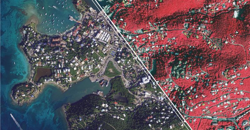
Hexagon’s Geosystems division has updated high-resolution aerial data covering the entire Commonwealth of Puerto Rico and the U.S. Virgin Islands as part of the HxGN Content Program.
Captured during the 2021-2023 flying seasons, the data set includes four-band, 6-inch resolution orthorectified imagery of Puerto Rico — except Isla Mona and Isla Desecheo, which are offered at 12-inch resolution. In the U.S. Virgin Islands, four-band orthorectified imagery of St. Thomas and St. John Islands are offered at 6-inch resolution and St. Croix Island at 12-inch resolution.
Additionally, updated 12-inch resolution digital surface model data of both regions are available.
In the past, aerial imagery from the HxGN Content Program has served as baseline data sets with unbiased records of property and infrastructure conditions prior to events such as Hurricanes Irma and Maria in 2017 and the earthquake of 2019. The imagery has also provided information for emergency preparation, response, and management.
In addition to emergency management, the HxGN Content Program aerial imagery is used in engineering, agriculture, utility, mapping, and artificial intelligence/machine learning applications.
The HxGN Content Program offers a large library of high-resolution aerial imagery, elevation data, 3D models and analytics of North America and Western Europe.
The refreshed Puerto Rico and U.S. Virgin Islands orthoimagery and DSMs are available now through a streaming subscription using standard mapping APIs or via pixel download on the Hexagon Digital Reality (HxDR) Data Store.
Ukraine’s allies in Europe are sending the country new UAVs and counter-UAV equipment, reported The Defense Post.
German weapons provider Rheinmetall is preparing to send its LUNA NG (next generation) unmanned reconnaissance UAV to Kyiv, the company announced August 14. The system should be delivered by the end of the year, according to Rheinmetall.
The LUNA NG is part of a sizable military aid package for Ukraine initiated by the German government in July. Per Rheinmetall, the package includes a ground control station and several UAVs, as well as a launch catapult, an optional net equipment for catching landing UAVs and equipment for rapid repair. The system is mounted on a Rheinmetall HX truck with a swap body system.
The UAV is designed for a range of mission-specific payloads — including LTE network and electronic warfare support measures such as detection, classification and analysis of electromagnetic radiation for threat detection.
UAV can remain aloft for more than 12 hours and maintain a datalink range of up to 100 kilometers normally, and up to 300 kilometers when fitted with optional satellite communication equipment, according to Rheinmetall.
The Bundeswehr (the German military) has operated LUNA UAV systems since the early 2000s. Those were originally developed by German manufacturer EMT Penzberg, which was acquired by Rheinmetall in 2021.
Berlin has already delivered several reconnaissance UAVs to Ukraine, including 88 Vector UAVs from Quantum Systems, 20 RQ-35 Heidrun systems Sky-Watch, and 32 unspecified reconnaissance UAVs, as of August 9.
Ukraine will also soon receive a series of Cortex Typhon counter-UAV systems made by Norway’s Kongsberg, after the company signed an agreement via the International Fund for Ukraine.
The delivery consists of several Cortex Typhon systems — developed to counter a wide spectrum of UAVs with solutions to either physically harm or disable an aerial threat, Kongsberg said.
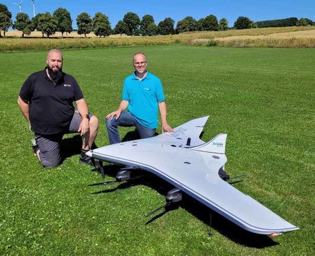
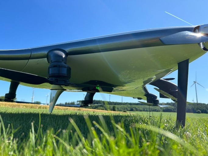
REIGL and StriekAir engineering GmbH have successfully completed the integration of an airborne scanning system, the RIEGL VUX-12023, on the StriekAir VTOL CarryAir UAV from Germany. During its inaugural flight, the integrated technology successfully captured accurate data of the ground structure.
The RIEGL VUX-12023 laser scanner is recognized for its precision and accuracy in aerial surveys. When integrated with the VTOL CarryAir, the UAV can reach a cruising speed of 85 km/h and offers users a combination of point cloud density and efficient data acquisition.
With the integration, users can acquire data about eight times faster than with conventional multicopters, according to REIGL. This time-saving feature aims to provide users with enhanced efficiency and data accuracy.
Matthias Hutecek (RIEGL) and Thomas Strieker (StriekAir engineering GmbH). (Image: REIGL)
The UAV can be utilized in a variety of applications — including surveying construction sites and infrastructure projects, mapping corridors, collecting topographic data for urban planning and environmental studies and more.
The RIEGL VUX-12023 offers smooth integration on UAS/UAV/RPAS, small manned airplanes and helicopters. It is offered as a stand-alone UAV lidar sensor and also in various fully integrated UAV-based laser scanning system with appropriate INS/GNSS system and optional cameras based on users’ needs.
Many have heard about efforts by Amazon to use UAVs for home delivery of orders within hours. Unfortunately, Amazon’s UAV trials have yet to be transitioned to “production” across the United States. Its website states that UAV deliveries are only available in College Station, Texas, and Lockeford, California.
Walmart is also in a trial phase of getting its rapid UAV delivery system working; however, its same-day UAV delivery is only servicing customers in the Tampa, Orlando, Phoenix, and Dallas areas. Nevertheless, there are many other automated deliveries underway around the world for meals and product deliveries, especially in Asia.
One segment where UAV deliveries appear to have been successful for medical samples and medications, which are now being shipped regularly on time-sensitive routes by UAVs (and, of course, several trial deliveries of these items are still underway).
The EMED transport/courier service used extensively by the UK National Health Service took part in one of the most recent medical shipment trials — which recently wrapped up in UK — with more than 400 pathology samples being rapidly shipped by fixed-wing UAVs between two hospital sites.
Loading a UAV in a UK medical trial. (Image: ESA)
The UAV used in the EMED trial was a tried and tested Swoop Aero Kookaburra III fixed-wing aircraft with a 3kg payload that flies at 330 ft in segregated airspace.
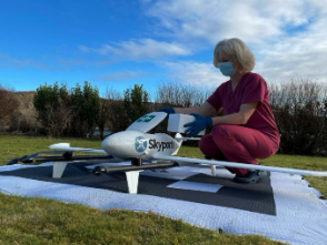
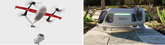
In the United States, OhioHealth aims to use a proven medical delivery system supplied by Zipline. Its plans for delivery UAVs include rapid shipments between Ohio medical facilities and prescription delivery to patients. By 2025, OhioHealth predicts that more than two million people in the Columbus area could be served by the Zipline delivery system.
OhioHealth plans to use Zipline’s Platform 2 delivery UAV — a fixed-wing carrier UAV with vertical take-off and landing (VTOL) capabilities able to autonomously hover and accurately lower a package-carrying “droid” into a tight delivery spot. The previous Zipline Platform 1 system drops packages by parachute, which requires a substantial area to receive deliveries. The “droid” has three directional fans that allow it to maneuver at the end of the tether to within six feet of the planned delivery point.
Over the last six years, Zipline has built up a whole fleet of Platform 1 aircraft and the complete infrastructure for its medical delivery operation in Rwanda.
In Rwanda, there was a need for different delivery methods to get medical supplies to hospitals, as communities are spread over large distances. Before bringing such a service to the United States, Zipline aimed to get a delivery service running, get experience, and de-bug and prove the system’s capabilities. Six years and half a million deliveries later, Zipline is now ready. For civil certification, the Federal Aviation Administration previously liked to see lots of evidence of established operational activity. Therefore, Zipline was fortunate to have six years of proven delivery activity in Rwanda when they looked to start up in the United States.
Platform 2 ‘droid’ containing a package is lowered on a tether from a hovering carrier drone. (Image: Zipline)
Zipline has also done everything needed to ensure the delivery process in Rwanda is as efficient as possible — from the order processing system, through packaging and loading into the UAV, a catapult launch system that accelerates the aircraft to climb-out speed, battery charging and exchange for each flight, autonomous navigation to the delivery point, parachute delivery at destination, autonomous return to base, and an automated capture system on arrival. As a result, it’s not unusual if a delivery can be dispatched within 90 seconds from receipt of an order.
The distances are large in Rwanda between where people are sick and where they can get help, and the necessary supplies may well be located elsewhere — at times, as much as 150 miles away. However, since Zipline deliveries became common, in-hospital maternal mortality rates have been reduced by 88% — quite an achievement. Each delivery that is dispatched really has the potential to save a life.
Now, Zipline has the potential to improve turn-round times for the health system in the United States. The company is ready to prove that the Platform 2 system makes very little noise because of specially designed propellers, that precise deliveries are possible, and it is even ready to take on regular parcel deliveries without being limited to only medical shipments.
Hopefully, some of the big retail organizations will be willing to watch, listen, trial and eventually bring the proven Zipline delivery system into their operations. There is much work to do to bring about regular UAV deliveries, but with a proven track record in Rwanda, the odds favor a successful outcome in the United States.
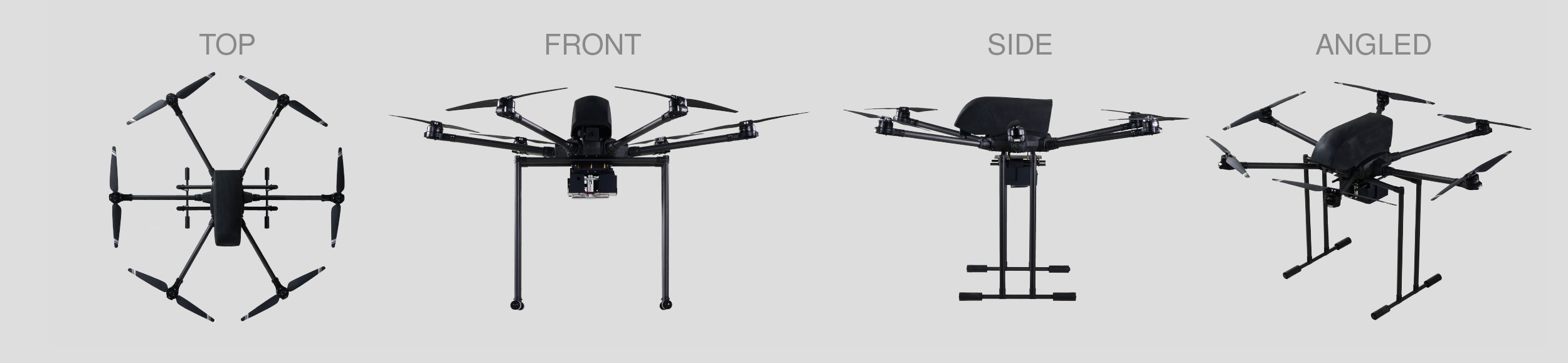
A2Z Drone Delivery, developer of commercial UAV delivery solutions, has launched its second generation RDST integrated cargo UAV, the RDST Longtail. The RDST Longtail features the company’s factory-integrated RDS2 drone winch, allowing payloads to be deposited safely from altitude so that spinning rotors are kept far from people and property.
The RDST Longtail serves as an off-the-shelf, ready-to-fly delivery UAV for last mile delivery. It can deliver or retrieve payloads up to 5 kg and over a distance of 11 km, making it suitable for various applications such as local parcel or food delivery, emergency medical deliveries, water sampling programs, offshore logistics, search and rescue operations and more.
The RDST Longtail continues the company’s focus on addressing consumer-protection concerns as the number of residential drone deliveries increases. By conducting deliveries from altitude, A2Z Drone Delivery’s solutions protect recipients from spinning UAV propellers, while mitigating privacy concerns of low-flying UAVs. Depositing payloads from altitude also keeps the UAV high above trees, power lines and buildings, enabling longer sight distances for missions requiring visual line of sight.
With the upgrades made to the RDST Longtail, A2Z Drone Delivery aims to democratize drone delivery for residential delivery and cases where operators need to quickly and efficiently deliver or retrieve payloads. For example, A2Z Drone Delivery platforms are in use delivering emergency defibrillators to first responders in the field, collecting water samples for analysis and delivering supplies in disaster relief efforts.
The UAV can also auto-release packages without the need for a recipient to be present at the delivery location. This is made possible by the all-new bag auto-release mechanism, allowing for easy pickups and auto-releasing of bags during deliveries.
Designed to meet FAA regulations, the RDST Longtail is remote ID compliant with a factory-integrated remote ID beacon. The Premium edition of the drone can fly in inclement weather and features a quick-release battery system for minimal downtime.
“Our prototype RDST Longtail has already logged 500 flight hours conducting daily residential parcel deliveries near our Ground Zero Test Facility outside Shanghai,” said Aaron Zhang, founder and CEO of A2Z Drone Delivery. “Many of the upgrades included in this second generation RDST have been made in response to customer feedback on capabilities they need to deploy for missions in inclement weather. The RDST Longtail is the flexible commercial delivery UAV for last-mile deliveries that will round out a logistics fleet.”
For more information on A2Z Drone Delivery system, click here.
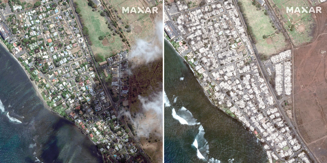
Satellite images taken on June 25 and August 9 show an overview of southern Lahaina, Hawaii, before and after the recent wildfires. (Image: Maxar Technologies)
The number of wildfires this year only increases as the island of Maui, Hawaii has been struck by several wind-whipped wildfires fueled by Hurricane Dora. Flames engulfed parts of Hawaii the morning of Wednesday, August 9, destroying a centuries-old town and killing at least 90 people, reported NBC News.
The fires took people on the island by surprise on Tuesday, as it left behind burned-out cars on once busy streets and smoking piles of debris where historic buildings once stood. Residents and tourists were forced to evacuate the area – including some who reportedly jumped into the ocean to escape the flames.
The National Weather Service believes the combination of high winds and low humidity is what caused the dangerous fire conditions across the island.
Satellite images also were taken, showing hundreds of shops and homes burned to the ground. The satellite images focus on the historic Lahaina area, which dates to the 1700s and has long been a popular tourist destination rich with native Hawaiian culture.
In one image from Maxar Technologies, the historic area of Banyan Court in Lahaina appears to have been mostly reduced to ash. Some 271 structures were damaged or destroyed, the Honolulu Star-Advertiserreported, citing official reports from flyovers conducted by the U.S. Civil Air Patrol and the Maui Fire Department.
The fires in Maui come after scientists have warned that wildfires are becoming more frequent and more widespread across the globe.
Rising global temperatures and the increased extreme weather has led to a surge in the number of wildfires rapidly consuming extensive areas of vegetation and forested lands. Wildfires have recently spread across Greece, Italy, Spain, Portugal, Algeria, Tunisia and Canada — resulting in mass environmental and economic damage as well as human casualties.
A passenger on a plane captured the devastating wildfire that decimated the historic town of Lahaina, Maui.pic.twitter.com/h262jX92yq
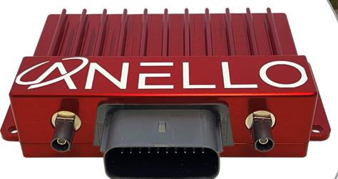
Powered by ANELLO’s optical gyroscope technology and artificial intelligence-based sensor fusion engine, the ANELLO GNSS INS delivers robust, high-accuracy positioning and orientation for applications such as agriculture, construction, trucking, and autonomous vehicles.
The ANELLO GNSS INS comes equipped with unaided heading drift of less than 0.5°/hr, dual multi-band real-time kinematic capable GNSS engines, ASIL-D ready automotive qualified CPU, automotive 2-wire Ethernet, and dual high-speed CAN FD interfaces.
It also features dual RS-232 interfaces, hardware precision time protocol, IEEE 802.1AS. The ANELLO GNSS INS is IP68 waterproof, as well as resistant to dust, salt spray and chemicals.
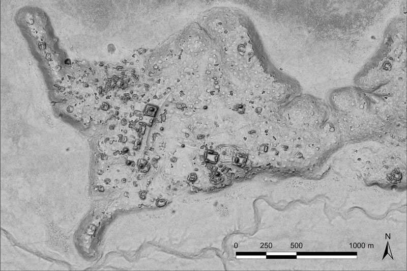
A relief of the ancient Maya site archaeologists are calling Ocomtún. (Image: Žiga Kokalj/ZRC SAZU)
In a biological preserve in Mexico’s Campeche State, a team of archaeologists have documented pyramids, palaces, a ball court and other remains of an ancient city they call Ocomtún, reported the New York Times.
Archeologists surveyed the site for six weeks in May and June, finding 50-foot-tall (15.2-meter-tall) structures resembling pyramids, as well as pottery and Mayan engravings they believe date to between 600 and 900 AD. The team determined the city was likely abandoned more than 1,000 years ago.
Mexico’s National Institute of Anthropology and History (INAH) hailed their findings late last month, saying they discovered the ancient city in “a vast area practically unknown to archaeology.”
“I’m often asked why nobody has come there, and I say, ‘Well, probably because you need to be a little nuts to go there,” said Ivan Sprajc, the survey’s lead archaeologist and a professor at a Slovenian research center, ZRC SAZU. “It’s not an easy job.”
Surveying the area has been revolutionized over the last decade by lidar — allowing researchers to survey densely forested areas that are difficult to explore on foot. Archeologists were able to use airborne lasers to pierce through dense vegetation and reveal the ancient structures and human-modified landscapes beneath.
INAH described the site as having once been a major center of Mayan life. Surrounded by wetlands, Ocomtún includes pyramids, plazas, elite residences and “strange” complexes of structures arranged almost in concentric circles, Dr. Sprajc told CNN.
“For example, we have several very curious architecture complexes of structures which are arranged in almost concentric circles. So, we are only guessing what this could be. Perhaps marketplaces,” he added.
Mexico’s National Institute of Anthropology and Historyteam plans to return next year for further investigation.
“Seen & Heard” is a monthly feature of GPS World magazine, traveling the world to capture interesting and unusual news stories involving the GNSS/PNT industry.
Bikes get tricked out
Image: Snik Bike
Snik Bike is a new app-paired tracking device designed to help users track their bikes if they are lost or stolen, reported North Shore News. Snik Bike Security Co-founder Fraser Vaage developed Snik Bike after having two of his bikes stolen. Snik equips any bike with a rechargeable location device that can be installed in five minutes or less. After pairing the device, the bike is automatically registered with Project 529, which is an online bike registration service. Vaage emphasized that while this device is not a ride-tracking software, such as Strava, it acts as an odometer, tracking overall mileage. The battery is only activated when a bike is stolen, Vaage said, therefore, it’s unlikely Snik will run out of battery. However, if it does, the device diverts to AirTag technology as a backup.
Lighthouses no more
Image: Wiltser/E+/Getty Images
With the wide adoption of GNSS, lighthouses on U.S. shorelines are no longer needed for navigation. To preserve these properties, the General Services Administration has been transferring ownership of the lighthouses to anyone willing to preserve them, reported The Guardian. This year, six lighthouses are being offered to federal, state or local government agencies, non-profits, educational organizations or anyone willing to make them publicly available for educational, cultural, or recreational purposes.
Location data ad weather resiliency
Image: DenisTangneyJr/E+/Getty Images
A Southern Methodist University research team, led by Nicos Markris, measured Dallas’ resilience by recording anonymous cell phone location data among residents in the Dallas metroplex before, during, and after the February 2021 North American winter storm. Measuring a city’s resilience is critical for planning responses to future events and uncovering potential vulnerabilities. By averaging location data, Makris and his team outlined the movement patterns of Dallas residents during a typical week. They compared the normal movement patterns to those during and after the week of the winter storm to determine when Dallas started getting back to normal.
GPS mitigates natural disasters
Image: Philip Thurston/E+/Getty Images
NASA’s Jet Propulsion Lab (JPL) is testing new ways to detect tsunami-like ocean waves before they cause catastrophic damage. The GNSS Upper Atmospheric Real-Time Disaster Information and Alert Network (GUARDIAN) is a new experimental monitoring system that can use data from clusters of GPS and other satellites to detect deadly waves triggered on Earth. Radio signals from GNSS are examined by scientific ground stations around the world. That data is then reviewed by the JPL’s Global Differential GPS network to help mitigate disasters. The GUARDIAN is still evolving and may be used in the future to develop early warning strategies, according to the United Nations’ International Committee on GNSS.
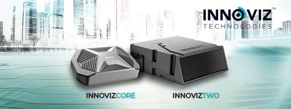
Innoviz Technologies, a lidar technology company, and the BMW Group, a manufacturer of vehicles and motorcycles, have collaborated on a B-sample development phase for a new-generation of lidar. Under the development agreement, Innoviz will develop the B-samples based on its second-generation InnovizTwo lidar sensor to enable Level 3 automated driving capabilities.
“Lidar is one of the critical technologies underpinning Level 3 or even higher automated functions,” Nicolai Martin, BMW Group’s SVP of driving experience, said. “Optimizing lidar technologies and costs are the major challenges in order to bring Level 3 highly automated driving into the mainstream.”
The companies already have been working together for a few years on an existing program that includes the first deployment of lidar-enabled highly automated technology on the BMW 7 Series, which will launch later this year.
In addition to the lidar solution for the BMW 7 Series, the BMW Group and Innoviz have started the first phase of development for a lidar-based minimal risk maneuver system (MRM). The MRM acts as a secondary safety driving decision platform that will leverage the InnovizTwo lidar sensor to manage real-time driving decisions.
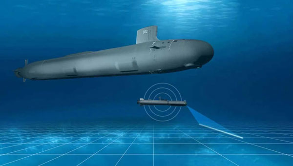
L3Harris has completed a fully autonomous launch and recovery of an autonomous underwater vehicle (AUV) from an underway submarine, referred to as Torpedo Tube Launch and Recovery (TTL&R). The launch used Iver4 AUV technology from L3Harris.
The L3Harris team worked closely with the U.S. Navy to demonstrate AUV launch and recovery through a test program aboard submarines and Navy support vessels.
The recovery of AUVs into an underway submarine allows the host platform to remain covert while the AUV performs surveys and missions in areas inaccessible to the host platform. The AUVs return with data that can be used for tactical and navigational planning — delivering manned and unmanned teaming to a fleet.
According to L3Harris, the company welcomes the continued opportunity to support the Navy in the development of manned and unmanned operational concepts. This capability will increase operational effectiveness and allow SSN-class submarines to serve as an AUV mothership.
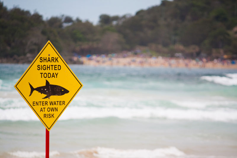
Off the coast of Long Island, New York, UAVs are sweeping the ocean patrolling for any danger that may lurk below the water. This follows a recent increase in shark encounters for beachgoers, reported USA Today.
According to George Gorman, the state’s park director in Long Island, there have been five shark bites reported this year as shark season is just beginning.
On July 6, the sighting of a 10-foot shark prompted officials to keep people out of the water at Robert Moses State Park. This is the same Long Island beach that delayed its opening on July 4, after a UAV spotted a school of 50 sand sharks off the coast.
Even if the injuries have not been serious, Gorman and others are concerned by the spike in shark sightings and encounters.
The UAVs conduct three sweeps a day on popular Long Island beaches — once before opening, sometime midday, and a final round before the end of the day.
Cary Epstein, a lifeguard supervisor who pilots UAVs at Jones Beach, explained how UAVs provide additional viewpoints to lifeguards on the beach.
“When you’re up in an elevated lifeguard station or a lifeguard stand, you can see up and you can see out, but you can’t see straight down,” Epstein said. “When we do have sharks that are eating on these fish, it’s very, very clear to us. You could see it, no questions asked.”
Additional state funding has been provided for more advanced UAVs to spot sharks.
New York Governor, Kathy Hochul, recently announced a new program that will provide $1 million toward purchasing 60 new shark-monitoring UAVs. The new devices will build on the enhanced shark safety measures at Long Island state park beaches — including more trained staff, new jet skis, and more buffer zones between swimming areas and fishing areas.