Tag: autonomous vehicles

  • A2Z Drone Delivery launches delivery UAV

    A2Z Drone Delivery launches delivery UAV

    Photo:
    Image: A2Z Drone Delivery

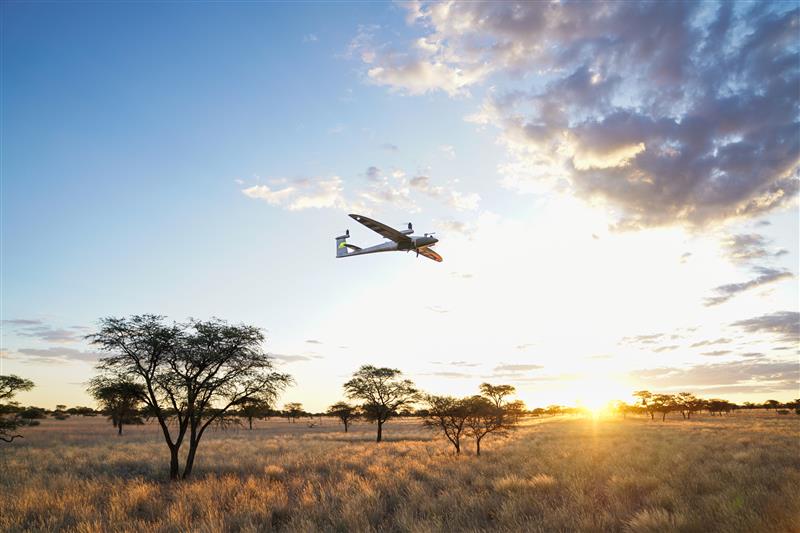
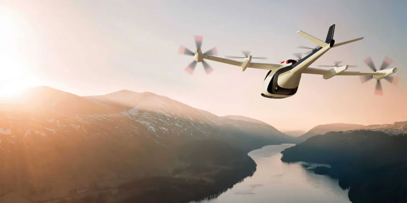
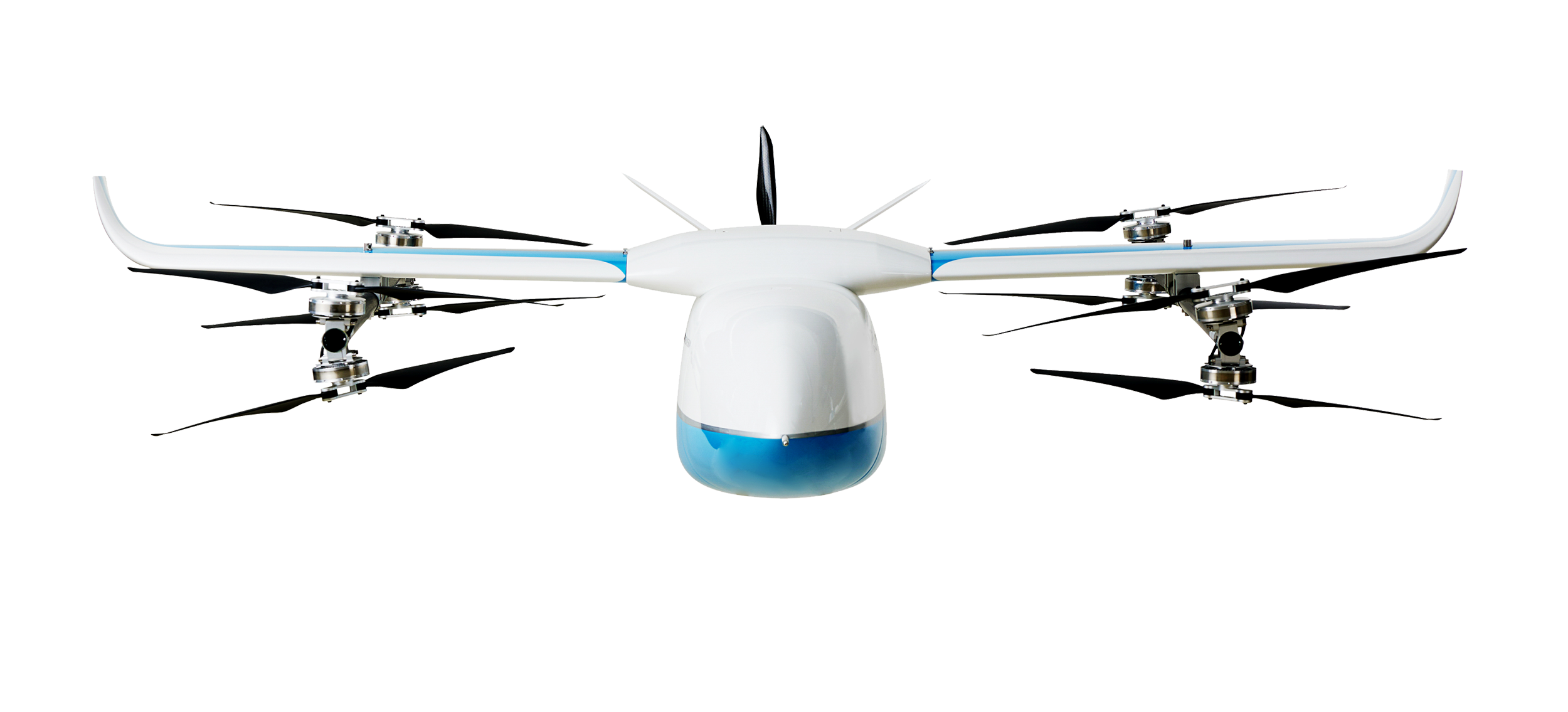
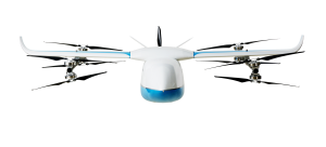
    A2Z Drone Delivery, developer of commercial UAV delivery solutions, has released its delivery UAV, the RDSX Pelican. The Pelican leverages a hybrid vertical takeoff and landing (VTOL) airframe with no control surfaces to combine the reliability and flight stability of a multirotor platform, with the extended range of a fixed-wing craft.

    With no ailerons, elevator, or rudder, the Pelican’s durable design eliminates common points of failure and extends operational time between maintenance overhauls. Designed to meet the 55 lb takeoff weight limitation for Federal Aviation Administration Part 107 compliance, the Pelican can carry payloads of 5 kg on missions up to 40 km, roundtrip.

    The Pelican can be optimized for extended range operations or to deliver payloads from altitude with the company’s RDS2 UAV delivery winch.

    Available in multiple configurations, the RDSX Pelican can be customized for an array of missions. The Pelican enables deliveries from altitude where spinning propellers are kept far from people and property, mitigating consumer privacy concerns of low-flying UAVs while abating intrusive rotor noise.

    Alternatively, for missions in which the UAV can safely land at its destination, a simple servo-release mechanism can release payloads and expand the Pelican’s payload capacity.

    Beyond logistics use cases such as residential deliveries, the Pelican is suitable for aerial mapping, UAV inspection, forestry services, search and rescue operations, water sample collection, offshore deliveries, mining, and more.

  • XTEND acquires Performance Rotors

    XTEND acquires Performance Rotors

    Photo:
    Image: XTEND

    XTEND has acquired Performance Rotors, a Singapore-based UAV inspection company. This acquisition will improve XTEND’s ability to offer human-guided, remote interactive operations in a range of inspection scenarios.

    “Performance Rotors’ mission has always been to develop UAVs and robotics solutions for data acquisition in GPS-denied and confined space environments, without the risk to human lives,” Keith Ng, co-founder and CEO of Performance Rotors, said. “We are confident that combining XTEND’s innovation XOS software with our world-class technology brings the best of the industry together in one powerful and easy to use solution that comprehensively addresses the critical challenges facing our customers today.”

    XTEND provides human-guided autonomous machine systems that enable operators to perform accurate maneuvers and actions in any environment with minimal training. Its XOS operating system enables practical autonomy allowing professionals to control UAVs and smart machines that carry out complex tasks that require human interaction and decision-making safely and remotely.

  • Quantum Systems survey UAV now available at Position Partners

    Quantum Systems survey UAV now available at Position Partners


    Image: Position Partners
    Image: Position Partners

    Position Partners has announced the availability of Quantum-Systems’ Trinity Pro remotely piloted aircraft system for the Australian and New Zealand market.

    The Trinity Pro is a UAV designed to adapt to changing demands, provide additional connectivity, and accelerate decision-making. The UAV features Quantum-Skynode autopilot, which uses a Linux mission computer. This provides additional onboard computing power, increased internal storage, versatility, and interoperability.

    Included in the Trinity Pro system is Quantum-Systems’ proprietary operations software, QBase 3D, and a portfolio of industry workflow and software integrations. The Trinity Pro’s capabilities include planning functions for missions requiring take-off and landing at different locations, allowing for efficient and safe long corridor flights and beyond visual line of sight operations.

    The platform also incorporates advanced self-diagnostics to ensure safe operation.

    The Trinity Pro now includes an enhanced terrain-following system, which improves safety during operations. The UAV also features automatic wind simulation for crash avoidance in bad weather and a linear approach for landing.

    The Trinity Pro is equipped with a downfacing lidar scanner that provides highly accurate ground avoidance and landing control. It is protected against dust and water damage and features increased wind limits of up to 14 m/s in cruise mode and 11 m/s during hover.

  • Percepto receives FAA waiver to scale shielded BVLOS commercial UAS operations

    Percepto receives FAA waiver to scale shielded BVLOS commercial UAS operations

    Percepto has received a waiver from the Federal Aviation Administration (FAA) that allows it to operate unmanned aerial systems (UAS) beyond visual line of sight (BVLOS) in shielded airspace — without humans onsite, and without ground-based or airborne detect and avoid (DAA) systems — for inspection and monitoring operations at critical and non-critical infrastructure sites nationwide.

    Under the waiver, low risk “shielded” BVLOS operations are authorized 200 ft above and around assets located on critical infrastructure sites. At non-critical infrastructure sites, shielded BVLOS operations are permitted 50 ft above and around the height of the tallest obstruction located within a half-mile radius of the site.

    The operations authorized under this approval build upon recommendations made by the UAS BVLOS Aviation Rulemaking Committee chartered by the FAA. The ARC recognized that shielded airspace near structures and other obstacles where crewed aircraft do not typically operate could be leveraged as a safety mitigation to support safe, scalable, and economically viable UAS BVLOS operations.

    The use of Percepto’s UAS to perform critical infrastructure inspections aims to improve worker safety and efficiency of operations by enabling inspections remotely from anywhere in the United States.

    Percepto is at XPONENTIAL May 9-11, at booth 3409.

  • Qualcomm and FlightOps collaborate on UAV tech for first responders

    Qualcomm and FlightOps collaborate on UAV tech for first responders


    Image: Qualcomm
    Image: Qualcomm

    FlightOps is collaborating with Qualcomm Technologies to develop UAV automation technology designed specifically for first responders. FlightOps has integrated its advanced UAV automation technology onto the Qualcomm Robotics RB5 platform — which has 5G connectivity, on-device artificial intelligence, and heterogeneous computing capabilities.

    The integration of FlightOps’ technology onto the Qualcomm Robotics RB5 will enable the platform to automate critical tasks such as flight planning, monitoring and data collection, enabling first responders to focus on the mission at hand.

    The technology is being showcased during XPONENTIAL May 9-11. FlightOps is at booth 4041.

    The live remote flights, operated from Denver and flown in San Diego, will demonstrate the capabilities of the integrated product and how it can be used to improve response times as well as enhance situational awareness during emergencies.

  • Honeywell AAM reference guide on vehicle certification

    Honeywell AAM reference guide on vehicle certification


    Image: Honeywell
    Image: Honeywell

    Honeywell has developed the advanced air mobility (AAM) industry’s first certification reference guide across key vehicle segments. Business and government leaders, engineers, media and any user with an interest in the future of flight can use the Honeywell State of UAS and UAM Certification Guide to help navigate and communicate the complexities of vehicle certification and operational approval across multiple vehicle segments.

    “We understand the challenges that professionals working in the advanced air mobility industry face as they look to navigate, track and ultimately comply with myriad developing regulations,” Jia Xu, chief technology officer, UAM and UAS, Honeywell Aerospace, said. “Because Honeywell provides certifiable, mission-critical systems that make AAM vehicles fly, it’s essential that we understand the certification landscape across all AAM segments. We initially developed this certification summary table as a quick reference for our own team; however, we quickly realized that the information here can benefit the wider industry. We intend to update this document regularly to help AAM companies keep pace with regulatory development.”

    Industry professionals can access the living document at the following link. The certification reference guide will summarize evolving Federal Aviation Administration and European Union Aviation Safety Agency rules across multiple AAM segments. It will also link to source documents that AAM professionals can reference to better understand detailed certification requirements.

  • Tallysman releases HC871SXF GNSS helical antenna

    Tallysman releases HC871SXF GNSS helical antenna


    Credit: Tallysman Wireless
    Credit: Tallysman Wireless

    Tallysman Wireless has released its dual-band low-profile helical GNSS antenna, the HC871SXF. It is designed for precise positioning, covering the GPS/QZSS-L1/L2, GLONASS-G1/G2, Galileo-E1, and BeiDou-B1 frequency bands, including the satellite-based augmentation system (SBAS) available in the region of operation — WAAS (North America), EGNOS (Europe), MSAS (Japan), or GAGAN(India).

    The HC871SXF has a precision-tuned, high-accuracy helical element that provides a suitable axial ratio and operates without a ground plane. These features make the HC871SXF suitable for lightweight, UAV navigation and a variety of precision applications.

    The HC871SXF low-profile helical antenna is approximately 10 mm shorter than the HC871 and provides the same performance. The antenna base has a male SMA connector. To facilitate installation, the base also has two threaded inserts and an O-ring to waterproof the SMA connection.

    The HC871SXF antenna also supports Tallysman’s eXtended Filtering (XF) technology.

  • OxTS releases INS for automation

    OxTS releases INS for automation

    Credit: OxTS
    Credit: OxTS

    OxTS has released the AV200, its inertial navigation system (INS) built for automation applications.

    The AV200 is designed to reliably give precise location data. It includes quad-constellation, dual-antenna, real-time kinematic (RTK) GNSS, to provide users with position data as well as its temperature-calibrated, multi-core inertial measurement unit. These technologies give the AV200 position accuracy within 0.05 m, heading accuracy of 0.2°, and velocity accuracy of 0.2 km/h.

    The AV200 is built using the same technology that is commonly used for NCAP test validation, which has become the preferred technology for OEMs globally to test vehicles in both test-track and real-world scenarios.

    The AV200 has also been built specifically to address the realities of the autonomy market.

    OxTS is at XPONENTIAL May 9-11, at booth 2148.

  • Trimble introduces RTX positioning solution for UAV deliveries

    Trimble introduces RTX positioning solution for UAV deliveries

    Image: Trimble
    Image: Trimble

    Trimble has released the PX-1 RTX for accurate and robust positioning and heading for commercial UAV delivery applications. This positioning solution enables UAV integration companies to add precise positioning capabilities so that operators can plan and execute takeoff, navigation and landing tasks as UAV delivery advances to take on more challenging operations.

    The PX-1 RTX leverages Trimble’s CenterPoint RTX corrections and small, high-performance GNSS-inertial hardware to provide real-time, centimeter-level positioning and accurate inertial-derived true heading measurements. This solution allows operators precise control of UAVs during takeoff and landing to tackle more demanding operations in tight or partially obstructed spaces.

    It also minimizes operational risks from poor sensor performance or magnetic interference by ensuring greater positioning redundancy, which is especially important as commercial UAV delivery operations venture into difficult urban and suburban environments.

    The Trimble PX-1 RTX solution is available through Trimble Applanix sales channels. For more information click here.

    The launch will be held at XPONENTIAL. Visit Trimble at Booth 1806 to learn more.

  • Russia blames Ukraine for overnight UAV attack on the Kremlin

    Russia blames Ukraine for overnight UAV attack on the Kremlin

    Image: Screenshot of video posted by Reuters
    Image: Screenshot of video posted by Reuters

    On May 3, Russia claimed Ukraine had launched an overnight UAV attack on the Kremlin in an effort to assassinate President Vladimir Putin, reported multiple news sources including NBC News and Reuters. President Volodymyr Zelenskiy quickly denied any Ukrainian involvement.

    A video taken of the incident posted on social media shows two UAVs aimed at the Kremlin that were promptly shot down.

    A Ukrainian official stated the incident suggested Moscow was preparing a major terrorist provocation, reported Reuters. Putin’s office said Russia reserved the right to retaliate and that it regards the incident as a planned act of terrorism and an attempt on the president’s life.

    A Russian agency also stated Putin was not at the Kremlin at the time of the incident.

  • Topodrone partners with Rasa Surveying on coastal mapping of the Philippines

    Topodrone partners with Rasa Surveying on coastal mapping of the Philippines

    Image: Topodrone
    Image: Topodrone

    Topodrone and Rasa Surveying have partnered to advance airborne surveying approaches and accommodate coastal management and monitoring demands in the Philippines.

    The approach of Rasa Surveying synchronizes current photogrammetry and lidar practices with the bathymetric data collection capabilities of Topodrone’s Aquamapper. The coupling of orthophotos, above and below waterline point clouds, and bathymetric data aims to support authorities in managing coastlines and enhance the resilience of coastal communities.

    “Coastal cities in the Philippines are vulnerable to the effects of climate change and climate-related disaster events,” Maxim Baklykov, Topodrone CEO, said. “However, coastal areas are expensive and challenging to map using conventional technologies. UAV-based surveying of coastal environments allows quickly and accurately to collect shallow water data and details on the land-sea interface.”

  • U.K. UAV surveying company creates specialized solution for rail clients

    U.K. UAV surveying company creates specialized solution for rail clients

    Image: Plowman Craven
    Image: Plowman Craven

    Plowman Craven, a United Kingdom-based aerial surveying company, has launched the Vogel Freedom UAV data collection solution designed for owners and operators of rail networks.

    The Vogel Freedom UAV solution aims to solve issues rail operators face in carrying out network surveys, including traffic disruptions and dangers created for workers needing access to infrastructure for ground point sensors.

    The platform requires fewer ground points to deliver topographical surveys. It can also produce sub-5 mm accurate rail system models using off-track sensor placement.

    Operating from offices in London and Hertfordshire, Plowman and Craven is one of the largest infrastructure surveying and inspection businesses in the U.K.

    “We developed Vogel Freedom in response to ever-increasing industry challenges and needs,” Steve Jones, head of new business at Plowman Craven, said. “It removes previous limitations to surveying and can add substantial value… all while improving workers’ safety and ensuring a safe and efficient rail service for customers.”