DJI has launched DJI Modify, its first intelligent 3D model editing software.
The solution can be integrated seamlessly with DJI’s enterprise UAVs and 3D modeling and mapping software, DJI Terra. When integrated with these products, the software can be used for aerial surveying, transportation and emergency responses.
Seamless workflow with DJI Terra
DJI Modify paired with DJI Terra offers users an end-to-end solution from modeling to model editing. Once DJI Modify has been enabled, DJI Terra files for model editing are automatically generated, including pre-identified objects and pre-processing of the model. It is designed to make repairing common 3D model defects seamless and efficient. As of early 2024, DJI Modify will only support repairing models built by DJI Terra.
Efficient 3D model editing
DJI Modify allows for model files to be quickly imported and exported to the DJI Terra and other third-party software. In the future, processed models can be shared to the cloud for online viewing and sharing via links without software installation, DJI said.
DJI Modify’s intelligent auto-repair editing supports flattening, editing textures, repairing water surfaces, removing floating parts, and filling holes. Edits can be made using one-click repairs or manually by selecting custom polygons, areas or meshes.
The software’s smoother model display technology allows high- and low-quality models to be viewed and edited in a single interface. Changes made can be synchronized across both models and previewed immediately, which allows users to address model editing issues in real-time.
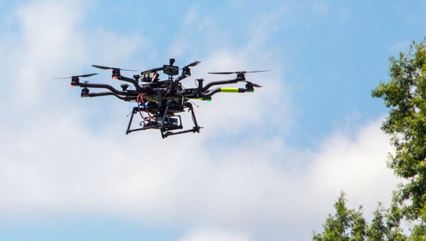
NASA researchers at Langley Research Center in Hampton, Virginia, have successfully flown multiple UAVs beyond visual line of sight (BVLOS) with no visual observer. The UAVs dodged one another and successfully maneuvered around obstacles before safely landing, the agency said. NASA conducted the tests to help researchers someday create autonomous, self-piloted helicopters that could carry passengers and cargo through busy aerospace.
Researchers used multiple Alta 8 UAVs loaded with software designed to enable autonomous flights. Although monitors observed the flights from a remote-control room at Langley, the UAVs successfully operated BVLOS.
NASA is also testing elements of autonomy using helicopters. They are designed to contribute towards the development of autonomous helicopters that can take off and land from “vertiports,” and transport passengers and cargo over both short and long distances.
The experiments are part of the agency’s Advanced Air Mobility Mission (AAM), which is designed to enable safe autonomous flight and integrate newly developed vehicles into the national airspace. The mission will “set the stage for a flourishing industry” of electric air taxis and UAVs by 2030, NASA says on its AAM website.
NASA will transfer the technology created during this project to the public to ensure industry manufacturers can access the software while designing their vehicles.
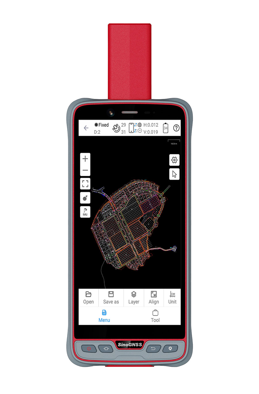
ComNav Technology has introduced its new handheld P6H solution. The device is designed for GIS data collection and outdoor operations. Featuring a GNSS high-precision positioning module, rugged IP67-rated design, and 6-inch sunlight-readable display, the P6H offers positioning accuracy even in harsh environments.
Equipped with a SinoGNSS self-developed high-precision K8 board and antenna, it can track all running and planned constellations with 1,590 channels, including GPS, BDS, GLONASS, Galileo, QZAA, IRNSS and SBAS.
The P6H offers users centimeter- or decimeter-level accuracy. Its IP67 rating protects against dust and water to enhance its efficiency and durability in tough environments.
The device comes equipped with Survey Master, boasting robust GIS functions, which allows users to take measurements of geographic elements and store the results as attribute data for subsequent analysis, calculation and visualization. It also includes a mock location function for users to accurately share Survey Master’s position with P6H. The location data can then be accessed on a third-party GIS software.
It is also compatible with common GIS software such as ArcGIS Collector, Mapit GIS and QGIS. Additionally, the P6H features an 8-core 2.0 GHz processor, up to 128 GB of storage and up to 6 GB of RAM to offer users smooth software operation and efficient data processing.
The handheld device, featuring a high-precision GNSS module and antenna, also incorporates 4G LTE, Wi-Fi and Bluetooth to improve its data transmission and sharing capabilities.
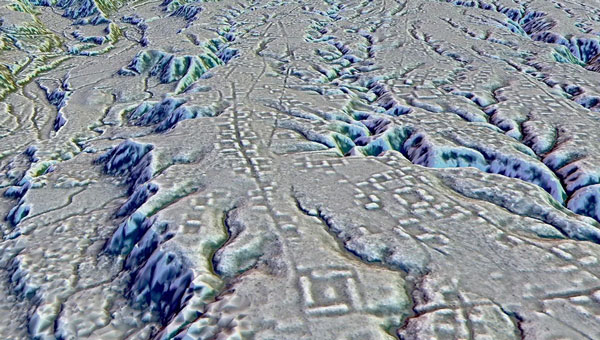
A lidar map of the city of Kunguints in the Ecuadorian Amazon reveals ancient streets lined with houses. (Image: Antoine Dorison and Stephen Rostain)
Archeologists have discovered a vast and highly complex system of ancient cities dating back nearly 3,000 years in the Amazon rainforest. Complete with a complex network of farmland and roads, the discovery is the oldest and largest of its kind in the region.
Located in Ecuador’s Upano Valley, the structures lie in the eastern foothills of the Andes mountains, according to a study published in the journal Science. After more than 20 years of research, the ancient urban centers were only discovered when the Ecuadorean government employed lidar technology.
“I have explored the site many times, but lidar gave me another view of the land,” archaeologist Stéphen Rostain, lead author of the study and director of research at the French National Center for Scientific Research (CNRS), told Live Science. “On foot, you have trees in the way, and it’s difficult to see what’s actually hidden there.”
A team of researchers from France, Germany, Ecuador and Puerto Rico conducted a lidar survey that covered roughly 300 km2. The survey revealed a landscape full of organized human activities, including more than 6,000 rectangular earthen platforms, as well as agricultural terraces and drainage systems.
According to the study, these structures formed at least 15 distinct settlements, which were connected by a system of wide, straight roads. Co-author Antoine Dorison, an archaeologist at the CNRS, said that this society’s complexity is especially evident in this web of streets, which were carefully constructed to cross at right angles rather than follow the landscape.
In recent years, lidar has been a vital tool for discovering traces of ancient civilizations. Lidar allows researchers to survey densely forested areas that are difficult to explore on foot and allows for the creation of accurate maps in a fraction of the time.
In August 2023, a team of researchers in a biological preserve in Mexico’s Campeche State used airborne lasers to cut through dense vegetation. This revealed ancient structures and human-modified landscapes beneath, including pyramids, palaces, and a ball court. The team was able to explore the dense area safely and identified the ancient Mayan city they discovered as Ocomtún.
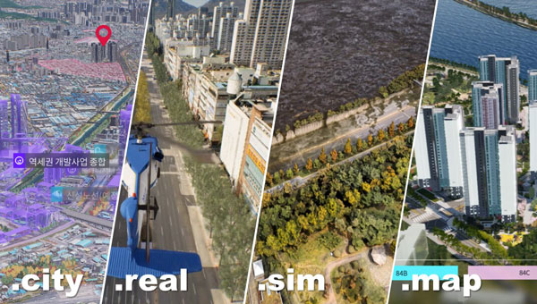
Techtree Innovation has launched AROUND, a high-precision, high-resolution 3D geospatial map platform designed to improve the quality and accuracy of existing 3D maps.
According to the company, AROUND is based on its existing 3D map generation and rendering technology. It offers four solutions for various industrial applications, such as urban or smart city planning, simulation, military and disaster management.
AROUND intends to provide high-precision, high-resolution 3D geospatial maps rendered with satellite maps, GIS data, 3D scanning using the photogrammetry software mapping (PSM) method, and high-end graphic production technology using the Unreal Engine, a 3D rendering platform.
The mapping platform aims to increase realism by implementing various visual geospatial information data — including terrain, buildings, vegetation, roads, transmission towers, traffic lights, signs and signboards, weather conditions, sunlight, coordinate data, elevation differences, and more from the real world. It is characterized by having accuracy and resolution within 5 cm and unifying all high and low altitude resolutions.
AROUND can be used for digital twins, smart city construction, autonomous driving, aviation, military training and education, disaster prediction, smart city or urban planning, review, architecture, design and more.
Image: Techtree
The platform offers four geospatial 3D map solutions tailored to users’ individual needs:
AROUND.city
AROUND.city is a solution that simulates the construction and development of urban areas or buildings. Through city simulation, 3D visualization, and data, AROUND.city can be used for analysis of various environments such as commercial, cultural, and residential facilities, and for space, environment, planning, design, and landscaping. The platform is designed to aid in the establishment and exploration of alternative plans, progress of development and evaluation in urban planning.
AROUND.real
AROUND.real provides high-quality 3D visualization mapping data with all collisions and blocks placed, which can be used in simulators of aircraft such as urban air mobility (UAM), helicopters, airplanes, autonomous cars, and various transportation means based on the development platform.
Using digital twins, AROUND.real allows for safe testing in risky real boarding and training areas. It also implements a variety of accurate and detailed visual-spatial information data, such as real terrain and buildings, grass, roads, utility poles, traffic lights, signs and signboards, weather conditions, and sunlight.
Around.sim
AROUND.sim visualizes refined data on various environmental factors such as building wind, flood, and population density in a specific area using the high-precision, real-world terrain and structures provided by the AROUND platform. Through this, users can predict problems about complex future situations in the same environment as reality, derive insights, or propose solutions.
AROUND.map
AROUND.map is a 3D real-estate marketing solution that already has commercialization achievements in the construction and allotment market. It visually represents the vision and buildings of the future that do not exist at the time of pre-sale, addressing the disadvantages of the existing pre-sale market, and implements all visual expressions such as virtual tours of all surrounding locations and pre-sale complexes, traffic, development plans, development benefits, view rights, and sunlight rights, just like reality.
The collaboration aims to facilitate precise positioning for various applications, with a focus on high-precision agriculture, service robots, machinery automation, micro-mobility and emerging automotive applications, such as lane-accurate navigation and telematics.
PointPerfect is designed to provide centimeter-level accuracy and achieve convergence in seconds with 99.9% uptime reliability. The service ensures uniform coverage across the globe. Notably, PointPerfect’s recently introduced Localized Distribution feature is intended to reduce user data costs by using 90% less data than typical network real-time kinematic (RTK) services. This combination of low-bandwidth data stream and flexible service plans offers easy scalability for future needs.
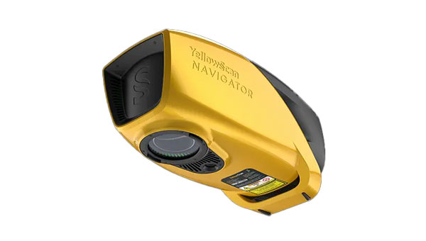
YellowScan has released its new bathymetric lidar system, the YellowScan Navigator.
The environmental hazards of climate change have an impact on human activities and infrastructure, such as drier seasons or heavy rains and flooding rivers. Precisely mapping both waterbed and land is required for monitoring, modeling and mitigating coastal erosion and flood hazards and for understanding biodiversity habits.
YellowScan Navigator is designed for surveyors to map underwater topography, in rivers, ponds and coastal areas.
The system features a laser scanner developed in-house over the course of five years and has been heavily tested to achieve optimal performance. The compact system can map waterbeds with a depth of up to three meters and can reach a depth of 18 meters in perfectly clear water conditions, according to the company. It can be flown up to 100m above the water surface and provides measurements with a precision accuracy of 3 cm. Additionally, a camera is embedded to offer true-color data visualization.
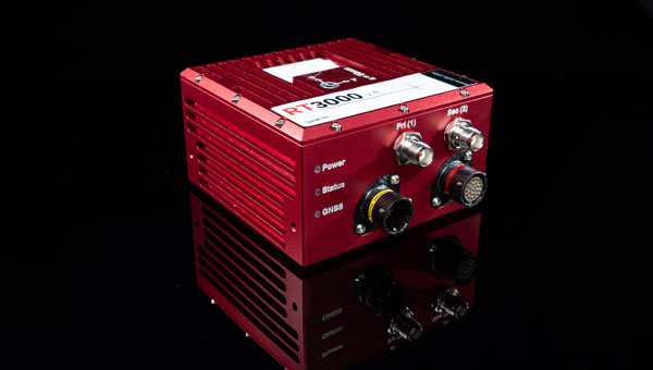
OxTS has introduced the RT3000 v4 GNSS inertial measurement unit (IMU).
By combining two survey-grade GNSS receivers with OxTS’ latest IMU10 inertial technology, the RT3000 v4 offers uninterrupted position, orientation and dynamics in challenging environments.
The IMU will reach the desired specification within three minutes of low dynamic movements, which reduces the time and space required for high dynamic maneuvers before each data collection.
Users can customize the INS with optional features and software integrations to create the ideal INS for individualized projects, including lidar surveying and mapping or positioning in GNSS-denied or challenged environments.
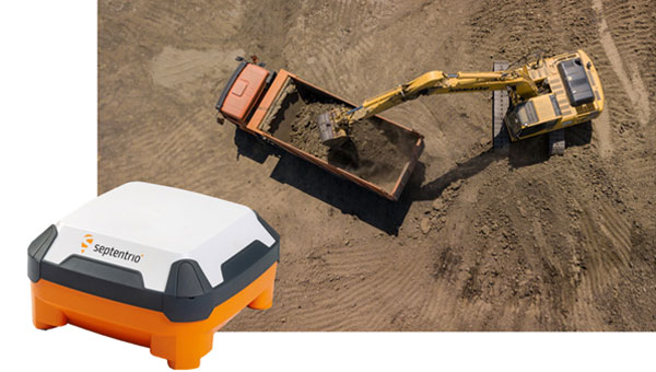
Septentrio has launched the AntaRx smart antenna designed for machine automation and control in construction, precision agriculture and logistics.
The smart antenna is enclosed in a rugged and compact housing for simplified installation. It can handle high levels of shocks and vibrations which makes it ideal for harsh industrial environments such as construction and mining.
The multi-frequency receiver offers centimeter-level real-time kinematic (RTK) positioning and can be used in inertial navigation system (INS) integration, dual antenna mode and 4G cellular communication. It is available in several configurations, including as a GNSS smart antenna or a GNSS/INS smart antenna system and can be integrated as an inertial measurement unit (IMU).
AntaRx is the latest addition to Septentrio’s machine control GNSS receiver portfolio. The receiver technology integrates the company’s GNSS+ algorithms, including advanced multipath mitigation, which offers uninterrupted operation in challenging conditions such as near high structures or machinery.
Point One Navigation has been selected by the Indy Autonomous Challenge (IAC) to provide real-time kinematic (RTK) corrections technology to all autonomous racing cars at the Consumer Electronics Show (CES) in Las Vegas.
The Polaris RTK network offers centimeter-accurate location services, which makes autonomous racing at high speeds possible. IAC race cars often exceed 180 mph and require precise location data for safe high-performance racing. The IAC chose Point One Navigation based on the company’s proven record in delivering precise location data to users through its RTK technology.
Point One Navigation’s RTK technology is now available for a wide range of autonomous applications — including UAVs, robots, construction and farm equipment, and autonomous cars and trucks.
The race takes place on Thursday, Jan. 11 at the Las Vegas Motor Speedway. For more information, visit the IAC website.
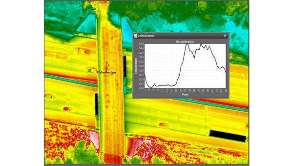
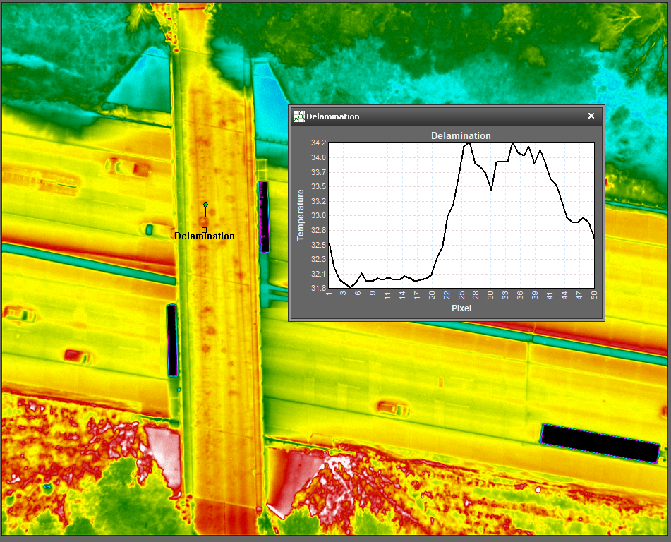
NV5 Geospatial’s thermal infrared (TIR) solutions for transportation infrastructure challenges are now being used in transportation projects to analyze concrete bridges in the Midwest.
This remote sensing technology offering enables local and regional transportation agencies to identify structural problems well before they reach the surface of concrete bridge decks.
Concrete bridge decks require periodic inspections for continuous maintenance, rehabilitation, and replacement work. TIR is used in non-destructive inspection techniques for analyzing concrete bridge decks and identifying potential delamination. This process is made more efficient with aerial collection.
The company recently conducted two separate pilot projects with two Midwestern states’ departments of transportation using aerial data collection to identify thermal anomalies of potential delamination for 200 bridge concrete surfaces. Both projects were completed by flying a fixed-wing aircraft at a low elevation with the thermal sensor mounted to its floor. The flights were conducted without ground-based support.
NV5 Geospatial’s project design focuses on optimal timing and resolution to maximize thermal contrast, which ensures accurate detection of features or patterns of interest. The acquired thermal imagery is orthorectified to create a seamless mosaic for each bridge. TIR imagery can be co-acquired with other airborne technologies, such as true color imagery and lidar, to provide supplementary information.
The TIR aerial solution allows users to capture up to 100 bridges in a single day and offers a detailed and short turnaround of data analysis. It identifies potential issues before ground truthing is required and supports state-wide inspection prioritizations.
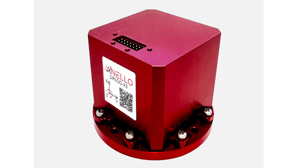
ANELLO Photonics has released the ANELLO X3, its 3-axis optical gyroscope inertial measurement unit (IMU) designed for GPS-denied and challenging environments.
The IMU leverages ANELLO SiPhOG (Silicon Photonics Optical Gyroscope) technology and serves as a light, low-power tri-axial optical gyroscope offering high accuracy, performance and reliability for autonomous applications.
The ANELLO X3 can be used in a variety of applications, including autonomous commercial and defense applications involving robots, UAVs, electric vertical take-off and landing (eVTOL) aircraft and various maritime and land vehicle applications, including high-accuracy surveying and mapping.