SingularXYZ has released the SAgro150 automated steering system for precision agriculture.
The product aims to provide farmers with an easy way to get started with auto-steering while increasing productivity. With full-constellation tracking capability, the SAgro150 realizes ±2.5cm auto-steering accuracy to maximizes land use and yield while saving resources such as water and fertilizer.
When compared to the first-generation SAgro100 system, the SAgro150 auto-steering system uses a single-antenna solution instead of a dual-antenna solution. It also features simpler integration options, only requiring a strong magnetic chuck to securely attach the antenna to the top of the tractor for satellite signal tracking. The new system also adopts dual gyroscope mode, enhancing the heading data reliability and compatibility with different tractors.
Upgraded from the SAgro100 auto-steering system, the SAgro150 has also inherited all of its advantages. Facing different tractor models, different farm terrains and working tasks.
The new system aids in work modes including rotary tillage, ridging, sowing and harvesting in straight line, curve, U-turn and more.
Leica Geosystems, part of Hexagon, has added new capabilities to the Leica BLK2FLY. It now has the ability to scan indoors, providing expanded coverage for complex scanning projects, and the ability to create digital twins for entire structures, both indoors and outdoors.
Hexagon upgraded the autonomous UAV scanning system to allow for safe, effective indoor navigation and capturing. This capability also expands the BLK2FLY’s ability to capture various environments outdoors.
The UAV can scan in areas without GNSS availability, opening reality capture opportunities in new settings, including hazardous indoor areas such as nuclear power plants. Increased performance of the autonomous navigation system heightens the sensor’s spatial awareness, allowing for obstacle avoidance in more confined spaces. This new capability relies upon advancements to Hexagon’s visual SLAM system, providing real-time spherical imaging that improves the BLK2FLY’s operating range to a radius of 1.5 meters.
The BLK2FLY complements Hexagon’s terrestrial and autonomous sensor. Users can also use Reality Cloud Studio, powered by HxDR, Hexagon’s cloud application that enables uploading of data to the cloud from the field using a tablet or smartphone to register, mesh and create 3D models of their data from the field automatically.
The technology’s new indoor scanning capabilities are available at no extra cost via firmware update to all current and future BLK2FLY users.
Space Systems Command (SSC), the National Reconnaissance Office (NRO), United Launch Alliance (ULA) and their mission partners successfully launched the “Silent Barker”/NROL-107 mission aboard an Atlas V rocket September 10, 2023, at 8:47 a.m. EDT from Space Launch Complex (SLC)-41 at Cape Canaveral Space Force Station, Florida.
The spacecraft was part of the Space Force’s Silent Barker satellite constellation network intended to provide space situational awareness, orbital surveillance and tracking.
According to a statement by ULA, Silent Barker is designed to detect and maintain custody of space objects. This capability enables indications and warnings of threats against high-value assets in geosynchronous orbit.
The mission aims to serves the needs of the U.S. Department of Defense and intelligence community by providing the capability to search, detect and track objects from a space-based censor for timely custody and event detection, the company said.
Surveillance from space allows the government to overcome existing ground sensor limitations and will enable the collection of timely satellite metric data around the clock.
One more Atlas V 551 remains in the NSSL inventory as the Space Force approaches the end of Atlas.
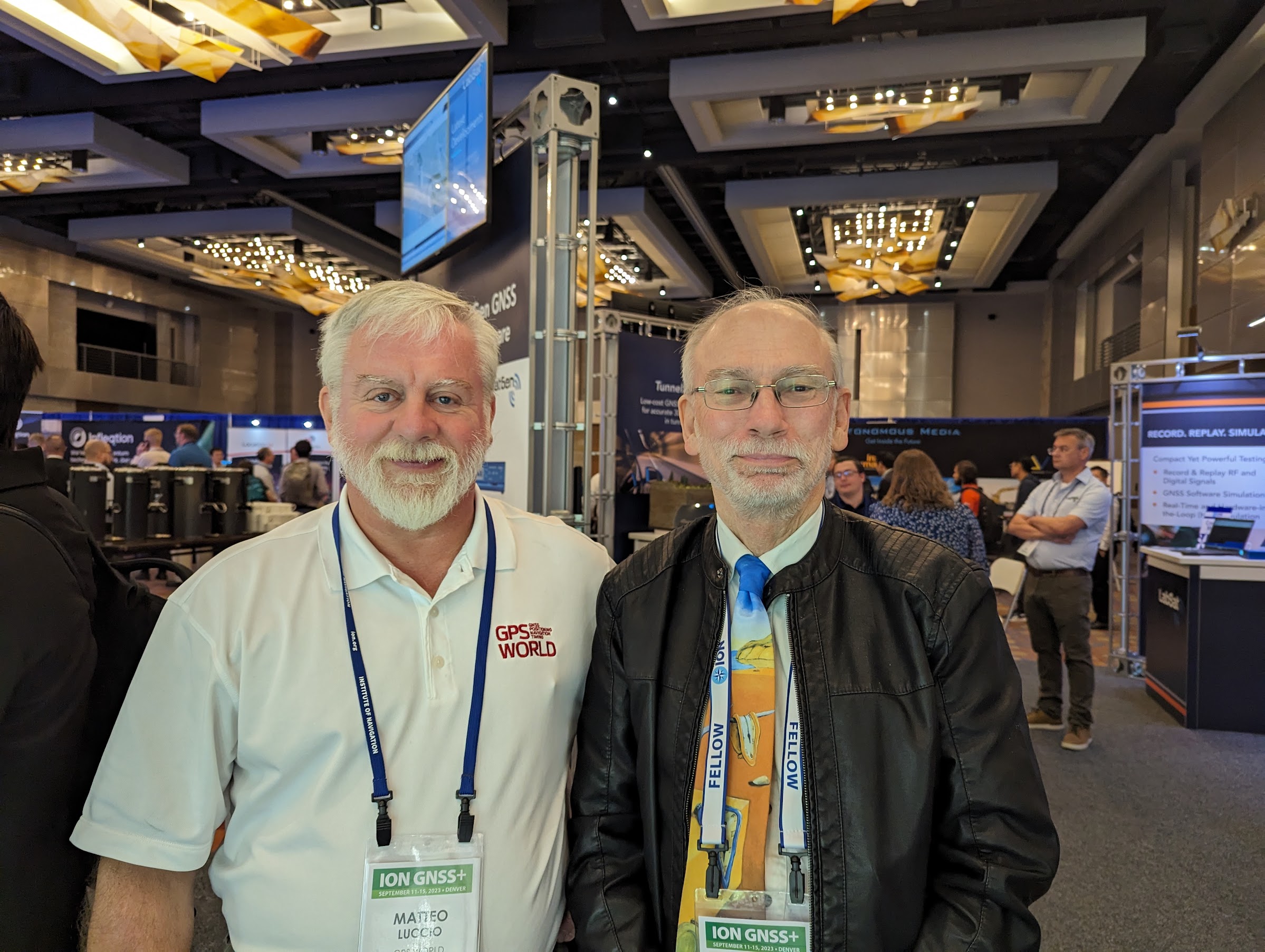
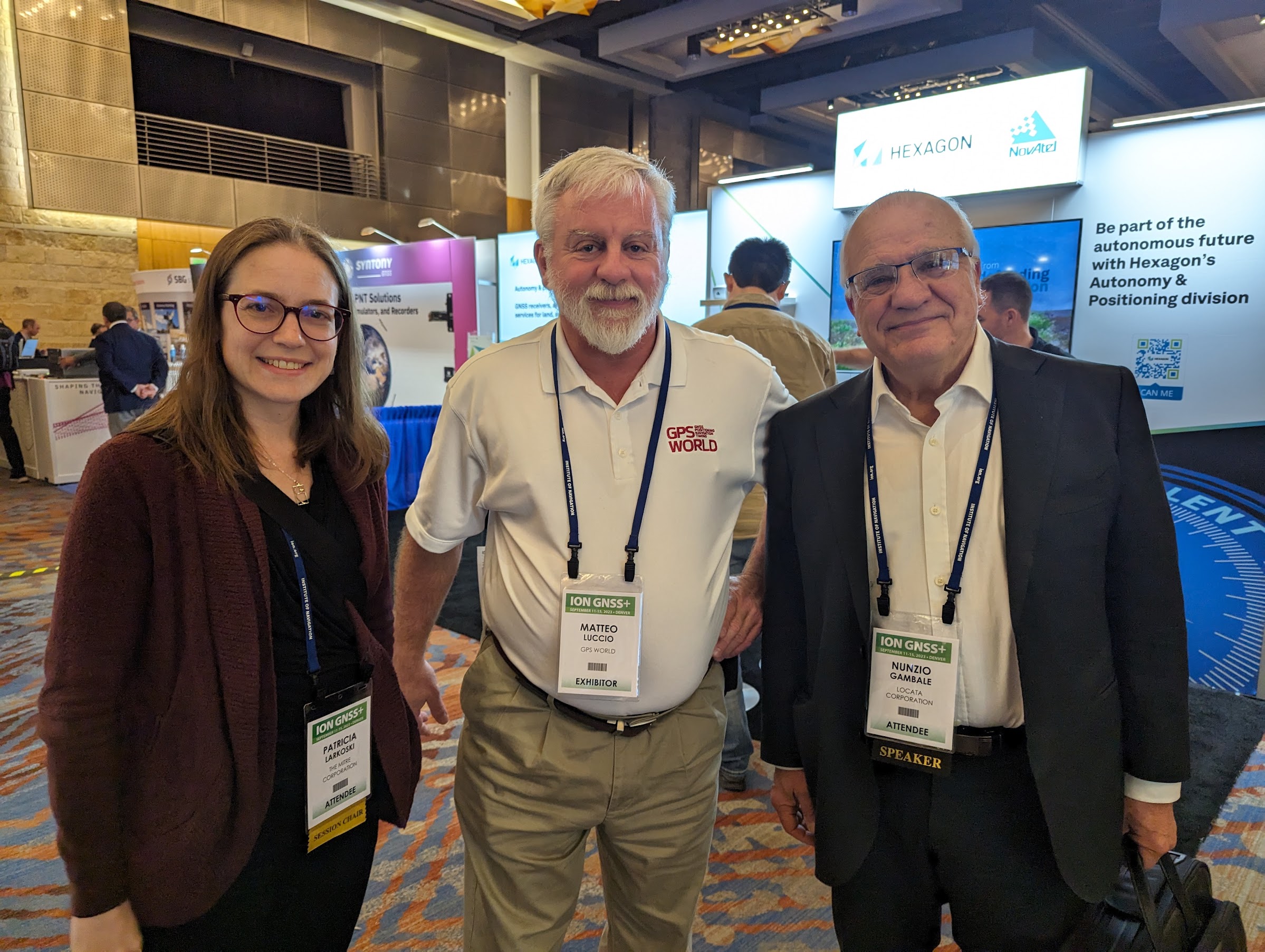
ION GNSS+ 2023 has officially concluded. GPS World staff had the opportunity to stop by several booths, attend a variety of educational sessions, and connect with industry leaders and attendees. Below are some of the show highlights and pictures of the beautiful city of Denver.
All photos were taken by GPS World Editor-in-Chief, Matteo Luccio.
Educational sessions
ION GNSS+ attendees gathered to hear a variety educational sessions offered throughout the conference.
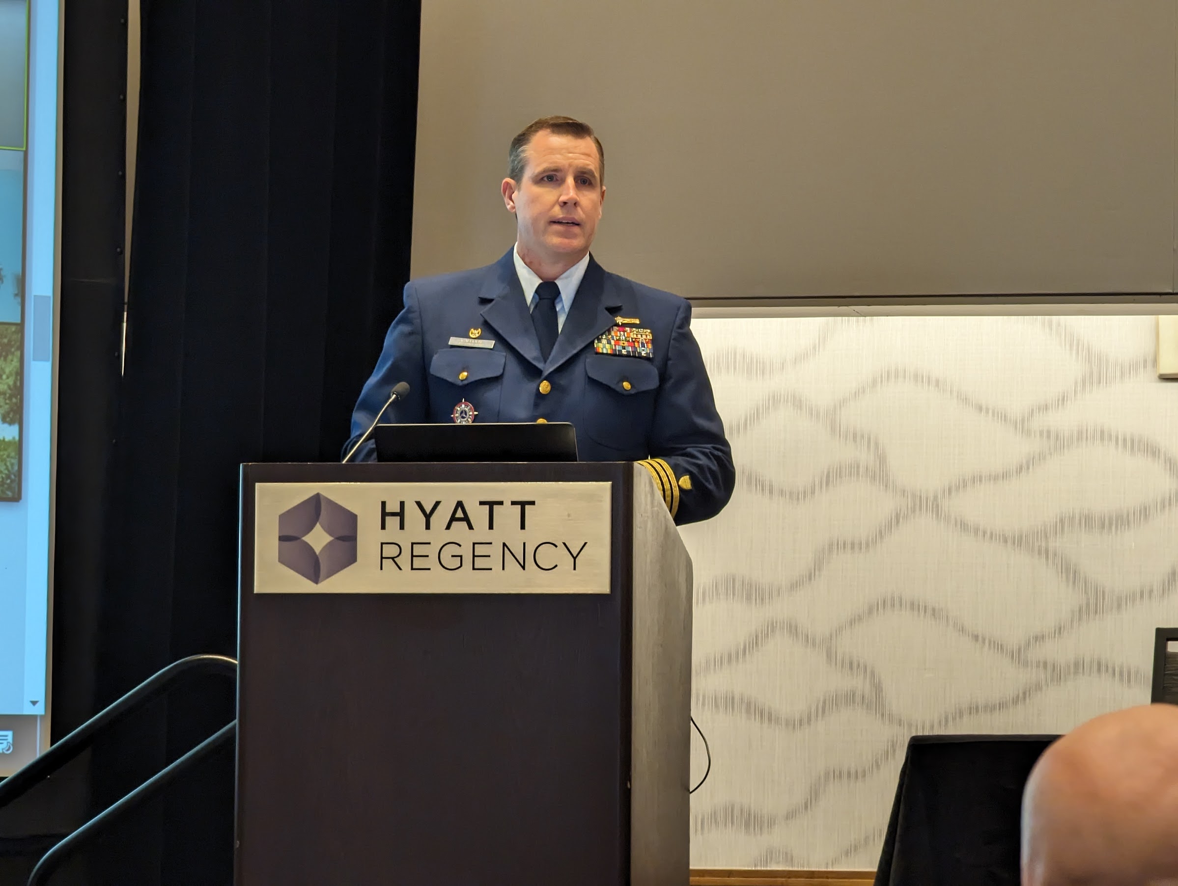
Captain Scott Calhoun, Commanding Officer, U.S. Coast Guard Navigation Center (NAVCEN) and Deputy Chair of the Civil GPS Service Interface Committee.
On the first day of the conference, Dr. Tzu-Wei Fang, Space Scientist, National Oceanic & Atmospheric Administration (NOAA) Space Weather Prediction Center, spoke during the “Remote Sensing, Timing, Space and Scientific Applications” session.
Dr. Ignacio Fernández-Hernández, Galileo Authentication and High Accuracy Manager for the European Commission, presented during the “Trends in Future Satellite Navigation Technology, System Design and Development” educational session.
Scott Thompson-Buchanan, Chief Cartographer, National Park Service, discussed the program’s partnerships and future plans.
Dr. Robert Hampshire, Deputy Assistant Secretary for Research and Technology and Chief Science Officer,
U.S. Department of Transportation, gave the keynote address during the 63rd Civil GPS Service Interface Committee.
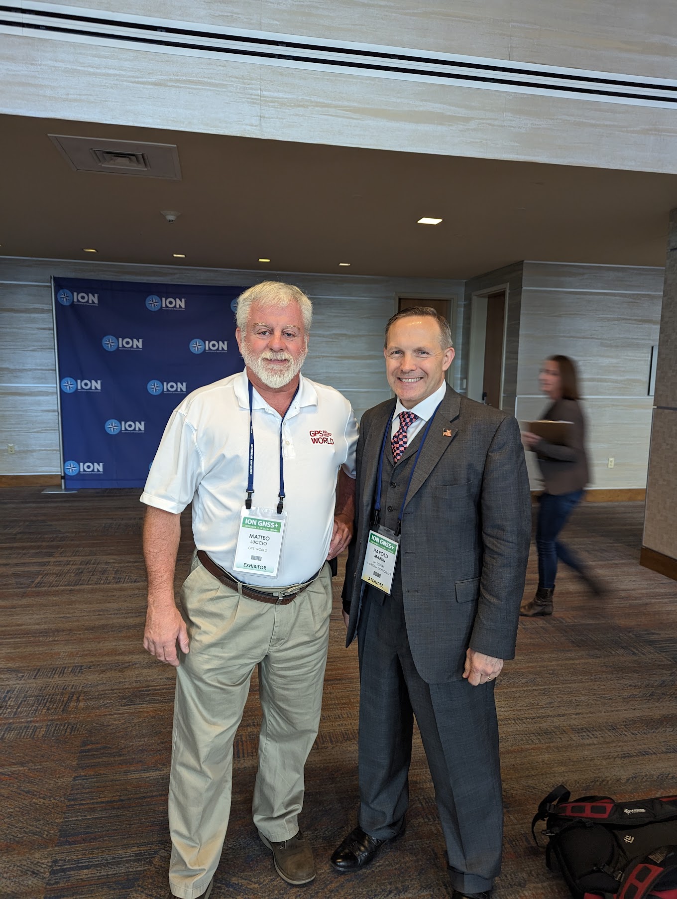
(From left to right) Colonel Andy Menshner, GPS Space and Ground (SML), Space Systems Command, U.S. Space Force; Lieutenant Colonel Robert Wray, Commander, Second Space Operations Squadron, U.S. Space Force; and Harold “Stormy” Martin, Director, National Coordination Office for Space-Based Positioning, Navigation, and Timing, during the Civil GPS Service Interface Committee.
Colonel Andy Menshner gave GPS acquisitions and development updates.
Panelists during the 63rd Civil GPS Service Interface Committee.
Click here to see more highlights from the 63rd Civil GPS Service Interface Committee, including the celebration of 50 years of GPS!
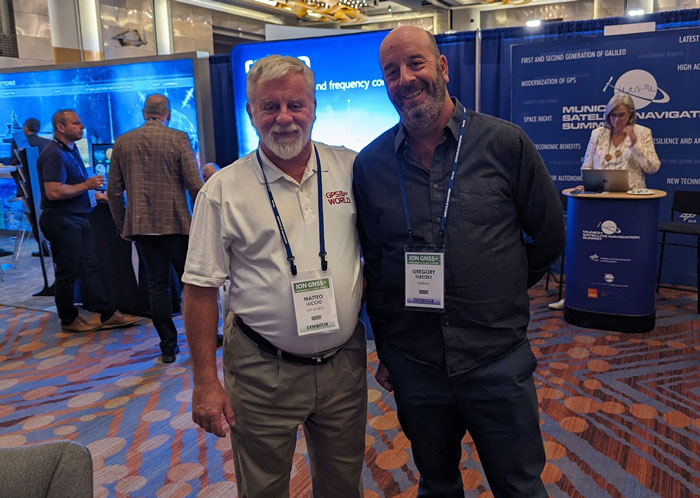
Matteo in the exhibit hall
GPS World staff met with our partners, contributors and readers on the show floor and at our booth.
The GPS World booth highlighted past magazine covers and our current issue of the magazine. Here, GPS World staff, Todd Miller (left) and Matteo Luccio (right), took the opportunity to meet with program leaders, partners and readers.
Harold “Stormy” Martin.
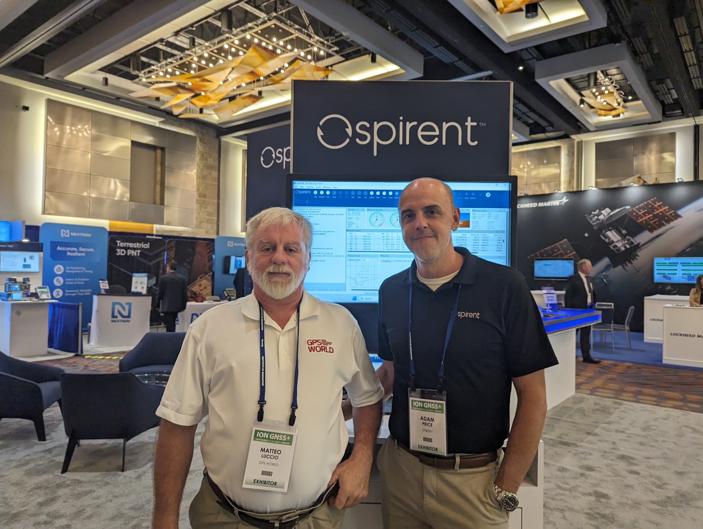
Adam Price, Vice President – PNT Simulation at Spirent Communications.
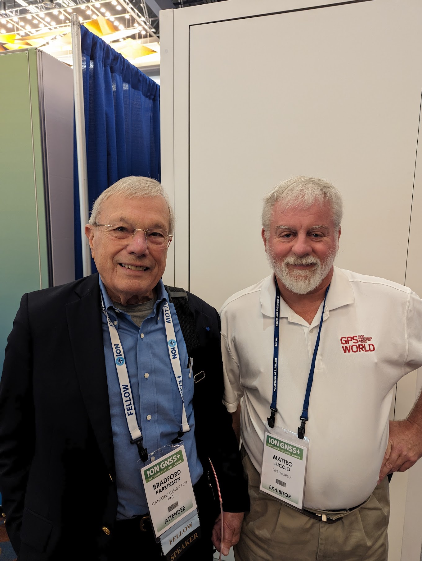
Dr Bradford Parkinson.
Kirstin Schauble and Gerhard Boiciuc, Anello Photonics.
Tim Waite and Mitchell McFee, GPS Networking.
GPS World‘s long-time contributor, Richard Langley.
Dr. Patricia Larkoski, The Mitre Corporation (left) and Nunzio Gambale, Founder and CEO of Locata (right).
Frank Van Diggelen, Google, and past President of ION.
GPS World Editorial Advisory Board member, John Fischer, Safran Navigation and Timing.
Chuck Stoffer (left) and Jeffery Sanders (right), UHU Technologies.
Gregory Turetzky, OneNav.
Karen Van Dyke, Director, PNT and Spectrum Management, U.S. Department of Transportation.
The beautiful city of Denver
ION GNSS+ 2023 took place in the heart of downtown Denver and came to a close on September 15. Beautiful blue skies and skyscrapers welcomed conference attendees from across the globe for the four-day event. Next year, ION GNSS+ is set to take place at the Hilton Baltimore Inner Harbor, Maryland.
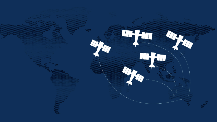
The Australian and New Zealand governments, with support from FrontierSI, are conducting a survey with original equipment manufacturers (OEMs) to identify the opportunities and barriers for integrating Southern Positioning Augmentation Network (SouthPAN) signal support in GNSS chips, devices and equipment.
SouthPAN is a Satellite-Based Augmentation System (SBAS) in the Southern Hemisphere and provides improved positioning and navigation services in Australia, New Zealand and maritime regions.
Precise positioning from the network offers improved accuracy down to 10 cm. SouthPAN provides augmented and corrected satellite navigation signals directly from the satellite rather than through a mobile phone, providing accuracy that overcomes gaps in mobile internet and radio communications.
SouthPAN early Open Services has been live since September 2022, and aviation safety-of-life certified SouthPAN services are set to go live in 2028. Safety-of-life certified services are designed to support end users engaging in life risking operations, such as landing an aircraft at an airport.
OEMs of positioning and/or navigation service equipment are asked to share insights on the support of SouthPAN’s three services into chips, devices and equipment. In particular, the company is looking for OEM’s’ views on barriers and opportunities for support of the L1, dual frequency multi-constellation (DFMC) and precise point positioning (PPP) via SouthPAN services.
The information provided will assist Geoscience Australia (GA) and Toitū Te Whenua Land Information New Zealand (LINZ) to maximize SouthPAN ‘s full potential and benefits.
Click here to access the survey. Responses will be accepted until Sept. 30, 2023.
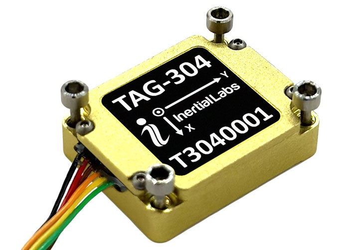
Inertial Labs has released the TAG-304, a three-axis gyroscope solution designed to stabilize platforms where low latency, wide bandwidth, high data rate, and low noise are required.
The TAG-304 gyroscopes can withstand extreme shock and vibrations in accordance with MIL-STD-810. Additionally, the gyroscopes are fully digitized (RS-422 interface), include built-in test functionalities, and have no moving parts.
The solution is a tactical-grade MEMS gyroscope designed for harsh environments and
tasks requiring accurate stabilization of assorted platforms. TAG-304 also features low latency (group delay), small size, 4K Hz data rate, 1K Hz bandwidth, and low noise, making it ideal for miniature electro-optical systems, gimbals, line-of-sight, and pan and tilt platforms stabilization and pointing applications.
The Mobile World Conference (MWC) returns to the Las Vegas Convention Center on September 26 to 28, 2023.
The event will feature exhibition from major U.S. operators, including AT&T business, T-Mobile business, and Verizon business as well as new sessions dedicated to sports and entertainment, software developers and the GSMA’s SEC CON event.
MWC, in partnership with the Cellular Telephone Industries Association (CTIA), invites industry leaders and attendees to connect and discuss topics such as the industry’s transition to a circular economy, the future role of artificial intelligence (AI) in society, and what comes after 5G.
To reflect the United States’ position as a global technology hub and a market at the forefront of 5G innovation, the event is centered around four key themes:
5G Acceleration, as adoption explodes to become the most common mobile technology in North America by 2025.
Age of AI, as the world awakes to the opportunities and challenges of generative AI.
Digital Everything, as the expansion of digital technologies is felt across every industry, from sports and entertainment to manufacturing, financial services and smart mobility.
Enterprise Mobility, as the revolutionary phase of 5G in enterprise is well underway.
The event will feature a variety of keynote speakers, including Amanda Toman, the director for the Public Wireless Supply Chain Innovation Fund at the National Telecommunications and Information Administration (NTIA) within the U.S. Department of Commerce.
For the first time, the GSMA will bring its SEC CON event to MWC Las Vegas on day two, welcoming leading security experts to explore the importance of keeping telecoms infrastructure secure in times of conflict.
A full directory and registration can be found on the MWC Las Vegas website.
Sentient Vision Systems has completed live demonstrations of its visual detection and ranging (vidar) payload enabled by artificial intelligence (AI) on Edge Autonomy’s VXE30 unmanned aerial vehicle (UAV).
The VXE30 is the latest version of the Stalker series of small UAVs from Edge Autonomy. When coupled with vidar, the VXE30 offers a passive, wide-area search capability, enabling it to serve a variety of maritime operations.
Vidar, developed by Sentient, uses AI, computer vision, and machine learning integrated with electro-optic and infrared (EO/IR) sensors to passively detect objects that are difficult for the human eye to spot or to recognize on a conventional radar.
This technology has been deployed on intelligence, surveillance, and reconnaissance missions (ISR), maritime patrol and border protection, as well as search and rescue missions since 2015. It is proven in conditions up to Sea State 6, which is defined as very rough with waves of 4m to 6m.
Last month’s column highlighted GEO-ESCON and how it supported the advancement of the science of geodesy. That said, the National Geodetic Survey (NGS) has been working to improve the National Spatial Reference System (NSRS) by replacing the North American Datum of 1983 (NAD 83) frame and all vertical datums, including the North American Vertical Datum of 1988 (NAVD 88), with four new terrestrial reference frames and a geopotential datum. Many of my previous GPS Worldcolumns have addressed various phases of the project.
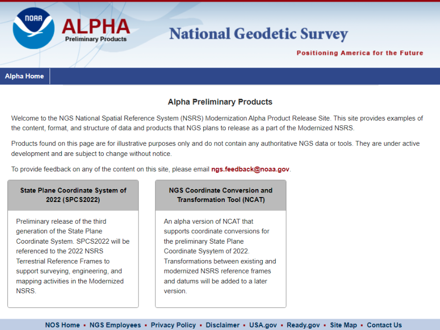
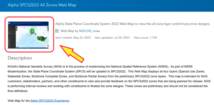
Recently, NGS has developed an Alpha site to enable users to preview preliminary NSRS products and services. I mentioned the Alpha site in my July column, in which I highlighted NGS’s presentations on the new NSRS at the International 2023 FIG Working Week.
Alpha preliminary products page. (Image: NGS)
The concept of the Alpha site is to provide examples of the content, format, and structure of data and products that NGS plans to release as a part of the modernized NSRS.
NGS highlights that these products are for illustrative purposes only and do not contain any authoritative NGS data or tools. It states that they are under active development and are subject to change without notice.
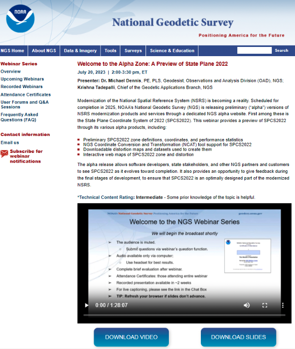
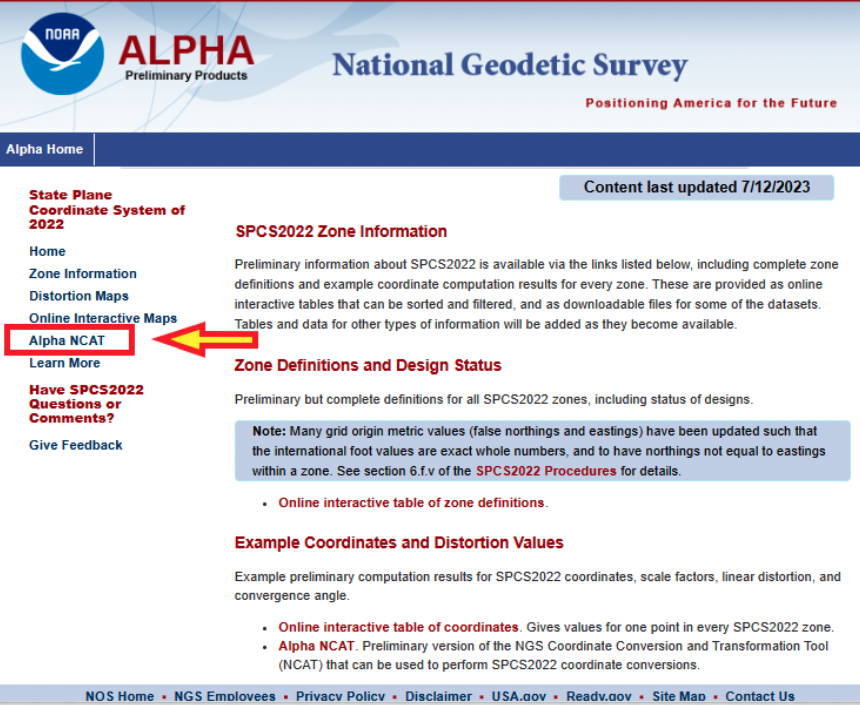
That said, NGS would like everyone to try the Alpha products and provide feedback to NGS. The first two Alpha products are State Plane Coordinate System of 2022 (SPCS2022) and NGS Coordinate Conversion and Transformation Tool (NCAT). On July 20, NGS held a webinar previewing the Alpha site. Readers can download the powerpoint and video of the presentation here.
Webinar on preview of SPCS2022. (Image: NGS)
As usual, Michael Dennis of NGS did a great job of describing the new SPCS2022, and the differences between the State Plane Coordinate System of 1983 (SPCS83) and SPCS2022. I have included a few of his slides that highlight the SPCS2022.
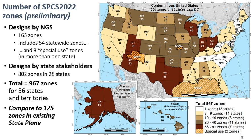
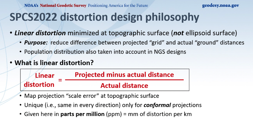
First, SPCS2022 has significantly more zones than the current SPCS83 zones. Second, SPCS83 map projections were designed to minimize linear distortion at ellipsoid surface, whereas the SPCS2022 map projections were designed to minimize linear distortion at topographic surface. The purpose being to reduce the difference between projected “grid” and “actual” ground distances.
Number of SPCS2022 zones. (Image: NGS)Linear distortion of SPCS2022. (Image: NGS)
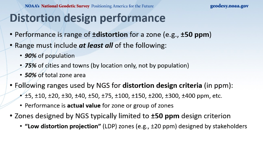
Dennis described NGS’s distortion design performance as seen in the image below. He explained that the performance is a range of +/- distortion for a zone, such as +/-50 ppm. The analysis involved determining parameters where the range includes 90% of the population, 75% of the cities and towns, and 50% of the total area. He highlighted those zones designed by NGS that where typically limited to +/- 50 ppm design criteria, but many low distortion projections (LDP) zones designed by stakeholders consisted of +/- 20 ppm design criteria.
Distortion design performance. (Image: NGS)
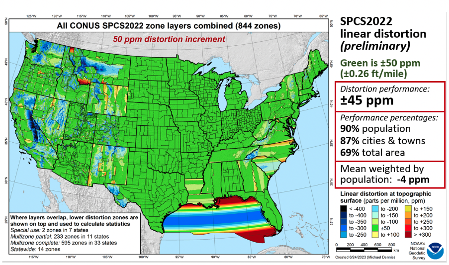
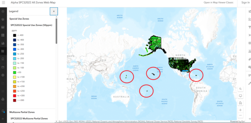
Dennis provided a slide depicting SPCS2022 linear distortion for all CONUS zones with a 50 ppm distortion increment as seen below. As indicated on the slide, green is +/- 50 ppm. The distortion performance is +/- 45 ppm.
All CONUS SPCS2022 zone layers. (Image: NGS)
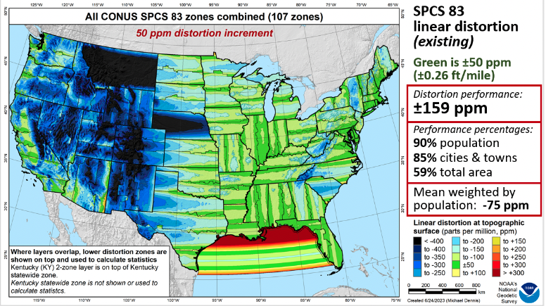
As a comparison to the existing SPCS83 zones, he provided a similar slide for the CONUS SPCS83 zones. See below. As in the previous slide, green represents +/- 50 ppm. The distortion performance is +/- 159 ppm.
All CONUS SPCS83 zone layers. (Image: NGS)
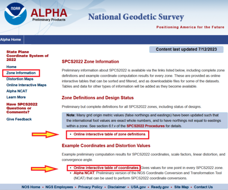
Now, let us look at the Alpha products. First, all zone information can be found here.
SPCS2022 zone information. (Image: NGS)
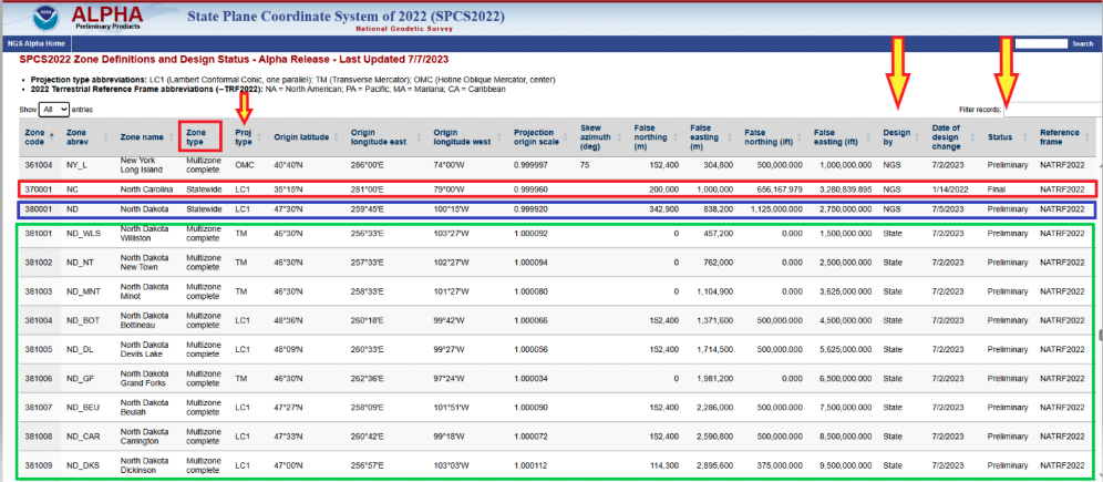
Users can click on the image below for a table of all zone definitions. The table provides the type of projection, if it was designed by NGS or the state, and the zone definition.
Online interactive table of zone definitions. (Image: NGS)
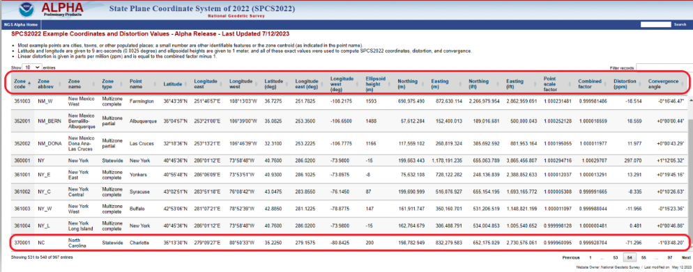
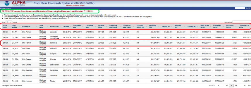
By clicking on the image below, users can obtain information for a point in a particular zone. The table provides northing and easting (meters and feet), scale factor, linear distortion, and convergence angle for a specific coordinate in a particular zone. It should be noted that all values that are provided in feet will be international feet units (ift).
SPCS2022 example of coordinates and distortion values. (Image: NGS)
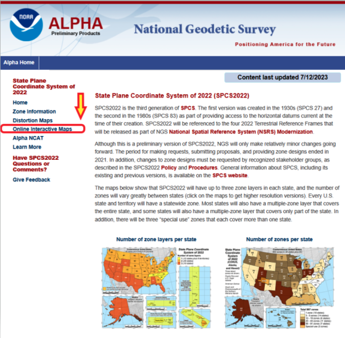
The Alpha page provides an online option to look at all maps. The arrow in the image below highlights the link to access the online interactive maps.
Alpha page for SPCS2022. (Image: NGS)
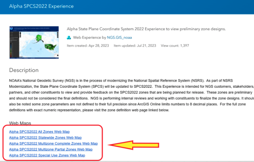
When users click the link on the page, they are directed to an ArcGIS NOAA web map viewer.
Alpha SPCS2022 experience. (Image: NGS)
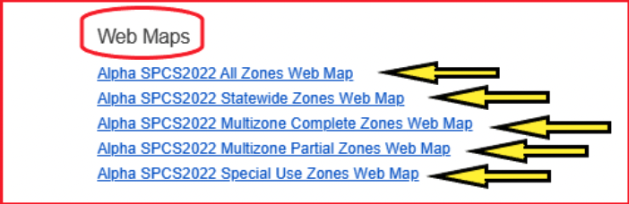
To access the online map function, users need to click one of the Alpha SPCS2022 zone options.
Alpha web maps. (Image: NGS)
Once users click on one of the web map buttons, another map page with a map icon appears on which userswill need to click to get to the map of zones.
Alpha SPCS2022 all zone web map. (Image: NGS)
After users click on the map icon, they will get another web page that contains the map zones based on their selection. In my example, I selected “all zone web map.” Once users get to this page, they can zoom into any area to find a particular zone.
All zone web map. (Image: NGS)
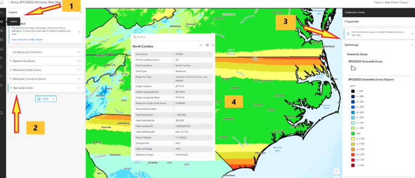
I zoomed down until I located North Carolina’s map zone. The web page provides access to various layers and information. First, if users move their curser over the layer button, a list of layers pops up. Next, select one of the layers, such as Statewide Zones, then the properties of the map are placed on the map. Finally, when readers click on the map itself, the information about the SPCS2022 zone appears on the map.
Alpha North Carolina Statewide Zone web map. (Image: NGS)
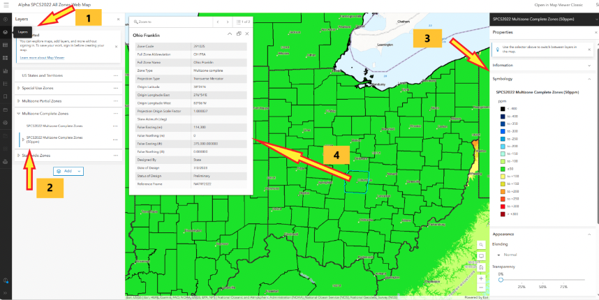
North Carolina is a state that elected to have a single statewide zone. Some states decided to design several LDPs that cover certain areas or cover the entire state. Ohio is a state that designed 89 LDPs that cover the entire state. Again, by selecting the layer button, users have an option to select multizone complete zones, the properties appear on the map, and finally clicking on the map provides the zone information for that zone. In this example, I clicked on Columbus, Ohio, which is in the Ohio Franklin Zone.
Alpha Ohio multizone complete zones web map. (Image: NGS)
Users can obtain specific information for a coordinate located in the Ohio Franklin Zone by clicking on the online interactive table of coordinates. Note that the distortion is 6.725 ppm at the coordinate in the zone.As previously stated, this was a user–defined LDP zone.
SPCS2022 example of coordinates and distortion values in Ohio Franklin Zone. (Image: NGS)
Another Alpha site available for users to evaluate is the NGS Coordinate Conversion and Transformation Tool (NCAT). NCAT is probably the tool that most surveyors will be interested in using and providing feedback to NGS. Users can access NCAT on the Alpha SPCS2022 webpage or by clicking here.
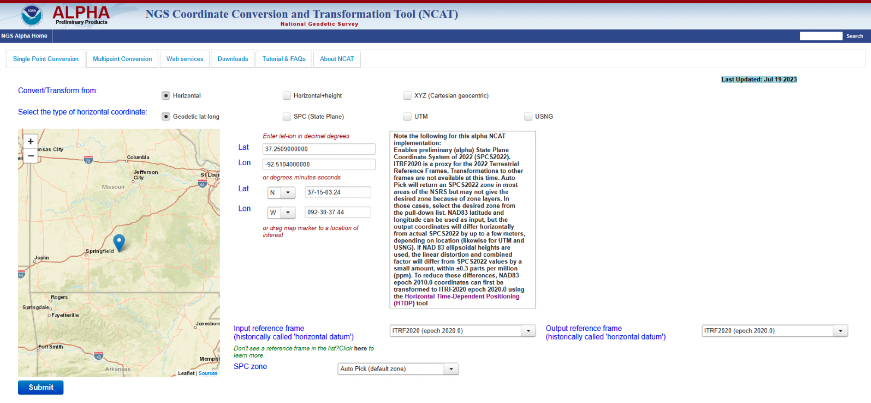
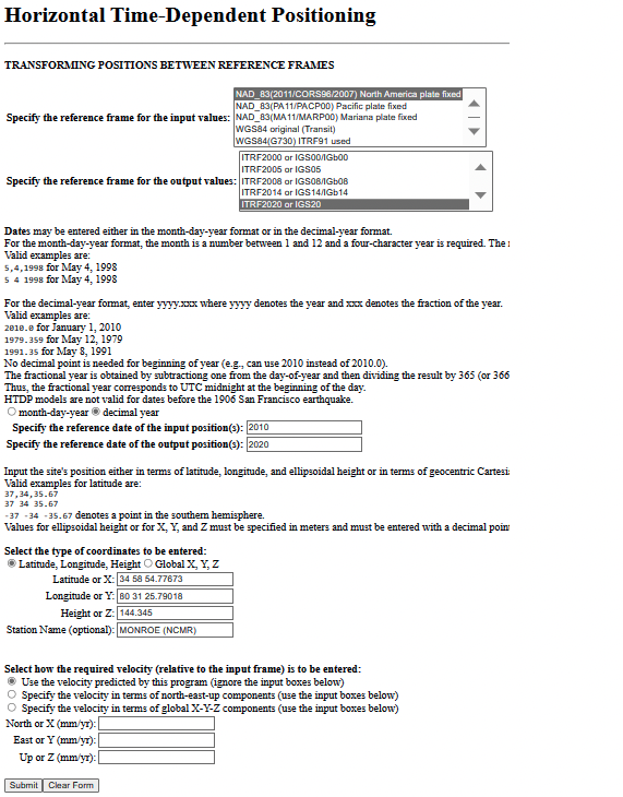
The Alpha NCAT website has a note about the coordinates that users should provide as input to the routine. The bottom line is that the input coordinates need to be in ITRF2020 (epoch 2020.0), or readers may not get their desired zone. NGS recommends that users convert the coordinates to ITRF2020 (epoch 2020.0) using the Horizontal Time-Dependent Positioning (HTDP) tool.
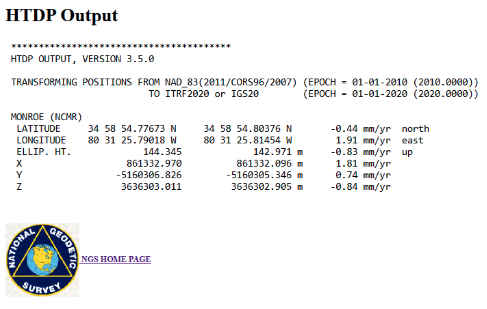
Users can access HTDP here. I provided an example of HTDP for a CORS in North Carolina. I used the NAD 83 (2011) [epoch 2010.0] published coordinates of the CORS as my input values.
Example of a HTDP computation. (Image: NGS)Output of a HTDP computation. (Image: NGS website)
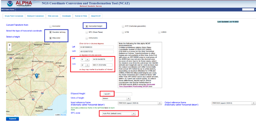
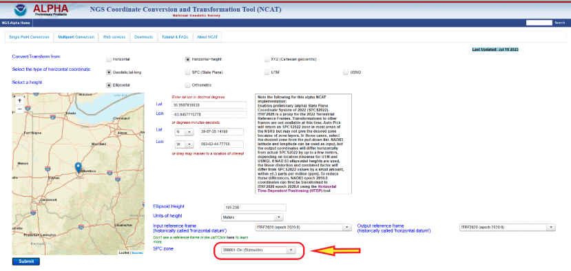
After using HTDP to transform the coordinates from NAD 83 (2011) to ITRF2020, I used the Alpha NCAT tool to compute the SPCS2022 values for the mark. I provided an example of the Alpha NCAT routine using the coordinates of the North Carolina CORS NCMR. The program defaults to horizontal only, so I changed it to the horizontal-height option. The user then enters the latitude, longitude, and height of the mark. Lastly, the user has an option to select the SPC zone or the program will select the zone based on the coordinates of the mark. In my example, I selected the auto pick option.
NCAT input for MONROE CORS (NCMR). (Image: NGS)
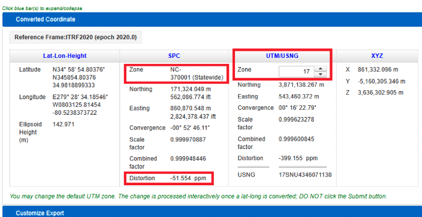
The image below provides the output of NCAT. I have highlighted a few items in the image. First, the program selected North Carolina’s Statewide Zone, the distortion is -54.554 ppm at this mark, and the UTM zone selected is Zone 17. The output also provides the scale and combined factors.
NCAT output for NCMR. (Image: NGS)
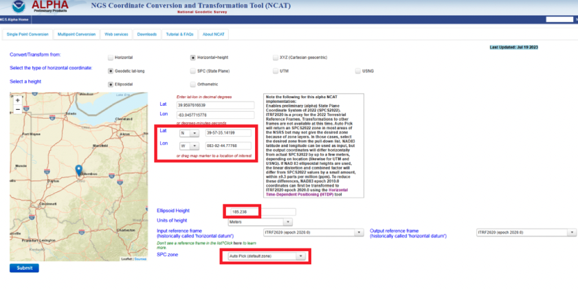
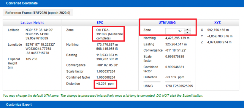
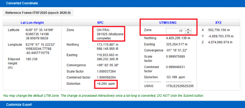
North Carolina is a state that elected to have a single statewide zone, but, as previously mentioned, some states decided to design their own LDPs. Again, Ohio is a state that designed LDPs that cover the entire state. Once again, I entered the coordinates into the input boxes and selected the auto pick (default zone) option. As indicated in the converted coordinates section, the program selected the OH FRA-391025 zone based on the coordinates of the mark. Notice that the distortion is only +8.024 ppm.
NCAT results for Columbus CORS (COLB). (Image) NGS)
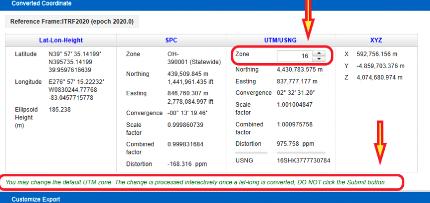
The user has the option to select a different zone than the default zone. The image below provides the SPC values for the COLB mark when selecting the Ohio Statewide Zone. Notice that the distortion value changes from +8.024 ppm to -168.316 ppm. Also, as expected, the UTM and X, Y, and Z values have not changed.
NCAT results for COLB selecting Statewide Zone. (Image: NGS)
One last option to highlight is that the user can change the default UTM zone by clicking on the up or down arrows under the UTM column. In my example, I changed the UTM zone from 17 to 16. Obviously, the values under the UTM column changed.
Option to change default UTM zone. (Image: NGS)
The concept of the NGS’s Alpha site is to provide examples of the content, format, and structure of data and products that NGS plans to release as part of the modernized NSRS. NGS states that these Alpha products are for illustrative purposes only and do not contain any authoritative NGS data or tools. It states that they are under active development and are subject to change without notice.
That said, NGS would like everyone to try these Alpha products and provide feedback to NGS, so that they can improve their products and services. I would encourage readers to try these Alpha sites and provide comments and suggestions to NGS.
Beep Inc, a provider of autonomous shared mobility solutions, and Oxa, an autonomous vehicle software developer, have partnered to deploy autonomous vehicles driven by Oxa in the United States. The collaboration marks Oxa’s entry into the U.S. market.
Under the partnership, Oxa’s autonomy software will be installed in a variety of vehicle types operated by Beep, from current passenger shuttles to future vehicle platforms.
The Oxa Driver is a software platform that combines sensor data from cameras, lidar, and radar to gain a more comprehensive view of the world around it when compared to vehicles that rely on cameras alone. This software uses AI to accurately sense and predict changes to the vehicle’s environment while learning from previous journeys.
Two of the Beep shuttles featuring Oxa software are currently operating at the recently opened SunTrax test facility in Auburndale, Florida, — the first location in the United States specifically designed for connected autonomous vehicle and standard automotive testing in a single site.
Oxa is using the facility to showcase its passenger transportation solution ahead of public availability in late 2023.
Two recent announcements showed China’s progress establishing its national “High-Precision Ground-based Timing System.” Some verbiage in the most recent announcement could indicate that the system is nearing completion.
The timing system is designed to support a vast array of scientific and technological applications as well as provide services when space-based signals are not available.
According to some Western observers, it is another example of China’s increasing lead over the United States in positioning, navigation, and timing (PNT) technology.
Completion of the terrestrial system could have even more troubling implications for the United States.
Recent Announcements
On May 21 this year, a government affairs article in Shaanxi’s “The Paper” announced accelerated construction in Xi’an of a science center. Its centerpiece will be the country’s High-precision Ground-based Timing System. It is not entirely clear from the article whether this site will be the engineering and administrative headquarters for the system, or one of several “timing stations.”
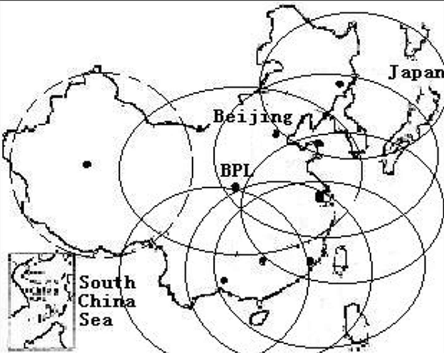
The article also says the national system will be the largest in the world — with more than 20,000 kilometers of optical fiber and 295 time and frequency transmission sites — and will integrate space- and ground-based signals.
The network, according to the article, will supplement and improve the new eLoran (sometimes mistranslated by software as “Roland”) system in the western portion of the country. It will also support legacy eLoran “long-wave” signals in the east ensuring that the entire nation is well served.
Graphic from 2014 Chinese Academy of Sciences paper on Laron showing projected coverage in the western part of the country. Subsequent papers and announcements have indicated that western part of the network is complete or soon will be. (Image: Chinese Academy of Sciences)
Accuracy for the system’s fiber-optic transmissions is claimed to be less than 100 pico-seconds, with differential eLoran at less than 100 nanoseconds.
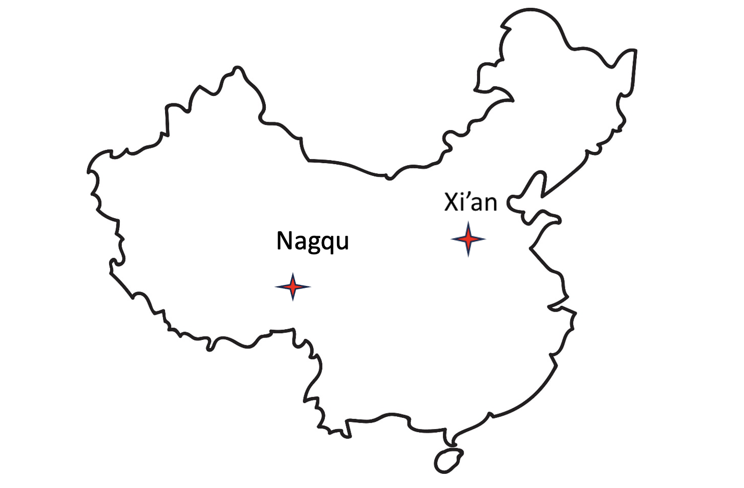
Construction recently announced in Xi’an and Nagqu as part of China’s High-precision Ground-based Timing System.
A much shorter press release was issued on June 8, announcing groundbreaking for a “timing station” in Nagqu on the Tibetan plateau in China’s west. The announcement said that, once the station was complete, China will “…realize national soil coverage of long-wave [eLoran] timing signals…”
Expansion of its eLoran and fiber infrastructure to serve the entire nation gives China what some have called the “PNT resilience triad” — signals from space, from terrestrial broadcast, and over fiber. The three sources of delivery are sufficiently different that an accidental or malicious disruption of one is highly unlikely to impact the other ones. Users accessing all three should experience minimal to no impact.
Both the May and June announcements said that finishing the timing project will benefit China’s national economy and national security.
Timing is essential tech infrastructure. More precise and robust timing enables improvements to current applications and the creation of new ones. For example, better timing can enable greater spectrum efficiency with more throughput on existing frequency bands. Highly precise fiber-based timing could also support using 5G telecommunications networks for hyper-precise positioning in autonomy corridors serving self-driving vehicles, UAVs, and other systems.
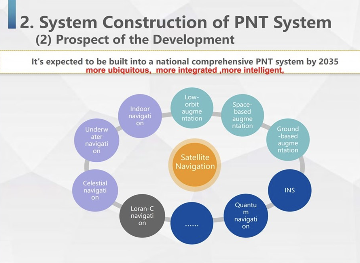
China’s ground-based timing system is part of a larger plan by its National Timing Service Center for a system of systems approach to PNT. Described as a “comprehensive approach” at the Standford PNT Symposium in 2019, the architecture has satellite-based navigation at its heart and includes a wide variety of other capabilities.
Graphic showing China’s plan for multiple, mutually supporting, diverse methods of positioning, navigation, and timing service and data. (Presentation by China’s National Time Service Center at 2019 Standford PNT Symposium)
Some observers trace China’s national PNT efforts to an incident in 1996 during the Third Taiwan Strait Crisis. Chinese forces fired three missiles toward a point in the sea offshore of Tiawan’s Kee Lung naval base. Two of the missiles were lost. According to the People’s Liberation Army this was because the United States denied or altered GPS signals that the missiles were using for guidance.
Known by China’s military as “The Unforgettable Humiliation” the incident sparked decades of effort to ensure China would never again be dependent upon another nation or space for PNT. The BeiDou global navigation satellite system and the High-precision Gound-based Timing System are the two most noteworthy accomplishments in this regard.
Implications for the United States
China’s ever-increasing lead in essential PNT technology and infrastructure is of great concern to many in the United States.
China’s global navigation satellite system, Bei Dou, is newer and, according to a presidential advisory board, substantially superior to GPS in many ways. Using it as an instrument of “soft power,” China is offering other nations BeiDou signals, along with discounted user and support equipment, as part of its Belt and Road, and Digital Silk Road initiatives. Where successful, these efforts erode both GPS usage and U.S. influence.
Of greater concern to many are the “hard power” implications of China’s PNT dominance.
While China has and continues to develop multiple and resilient sources of PNT, in the United States “GPS is still a single point of failure,” according to a member of the National Security Council.
As a result, if China were to interfere with GPS in some way, a U.S. response in-kind against BeiDou would have much less impact. This strategic asymmetry has been described by former CIA senior analyst George Beebe as “an open invitation” for mischief or attack. One that could easily lead to an escalating series of responses ending in an armed conflict no one wants.
At a more tactical level, China’s eLoran system extends 1,000 miles offshore covering Taiwan, the Strait, and all approaches. In a conflict to capture the island and make it subject to the Communist regime, China could block all signals from space while preserving its forces’ ability to maneuver and communicate. Already at a disadvantage having to deploy far from their support bases, this would further hamper U.S., Japanese, and other forces hoping to help Taiwan maintain its independence.
The U.S. Department of Defense boasts it can operate well in GPS-denied environments and says it is also working on alternative means of navigation for deployed forces.
This begs the strategic question, though, of whether the United States would be willing to come to the aid of Taiwan or another ally if the homeland were threatened with a prolonged and crippling disruption of GPS services.
Prior to Russia’s invasion of Ukraine, the Kremlin destroyed a defunct satellite and boasted it would shoot down all 32 GPS satellites and “blind NATO” if the alliance intervened. Many observers have wondered whether that has played into subsequent U.S. and NATO policy toward the conflict.
Unfortunately, little has been done to eliminate the possibility of a belligerent adversary holding the U.S. homeland hostage through GPS.
For two decades narrow government and industry interests in GPS production have successfully opposed any effort they see as possibly “competing” for space in limited budgets. Appeals that such projects would increase system security by “taking the bullseye off” GPS satellites and signals have been to no avail.
However, this may be changing. Several years ago the National Guard began development of a national timing architecture and network, called NITRO. The project supports the Guard’s own requirements to be able to operate without GPS and to aid state first responders. It is already in use in 7 states.
The future of NITRO is unclear, though, as the Department of Defense sees it as a civil defense rather than a national defense project and is no longer supporting it in the budget. Yet, the National Guard’s funding flows through defense appropriations.
As of this writing, the National Guard and NITRO remain stuck in a bureaucratic and budgetary no-man’s land with no clear path forward.
Qualcomm has entered a technology agreement with Hyundai Motor Group to integrate its Snapdragon Automotive Cockpit Platform into Hyundai Motor Group’s purpose-built vehicles (PBV).
The infotainment systems on the PBVs will use Snapdragon Automotive Cockpit Platforms for a “holistic, seamlessly connected and smart user experience,” Qualcomm said.
The PBVs are designed to deliver transportation, comfort, logistics, commercial and healthcare services. The latest generation of Qualcomm’s Snapdragon platform benefits from optimized power consumption, high-definition graphics and immersive multimedia and audio.
According to Qualcomm, the latest generation of Snapdragon Automotive Cockpit Platforms offer optimal power consumption while providing top-tier graphics as well as top immersive multimedia and audio experiences.
The platforms offer location services, emergency calling, noise reduction, and dual SIM capability as well as cloud-based monitoring and management systems. Using Qualcomm’s artificial intelligence (AI) engine and machine learning (ML) capabilities for intuitive and intelligent systems, Snapdragon can support digitally advanced applications, including in-vehicle virtual assistance and adaptive human interfaces. It can also facilitate natural communication between the vehicle and passengers for added safety and comfort.
The platform also employs dynamic configuration management to ensure vehicles are kept up to date. Reliable cloud-based vehicle monitoring and management also is possible through cloud service solutions.
Qualcomm and Hyundai Motor Group have been collaborating since 2011 on in-vehicle mobile communications using Snapdragon Automotive Connectivity Platforms.


 Frank Van Diggelen, Google, and past President of ION.
 GPS World Editorial Advisory Board member, John Fischer, Safran Navigation and Timing.
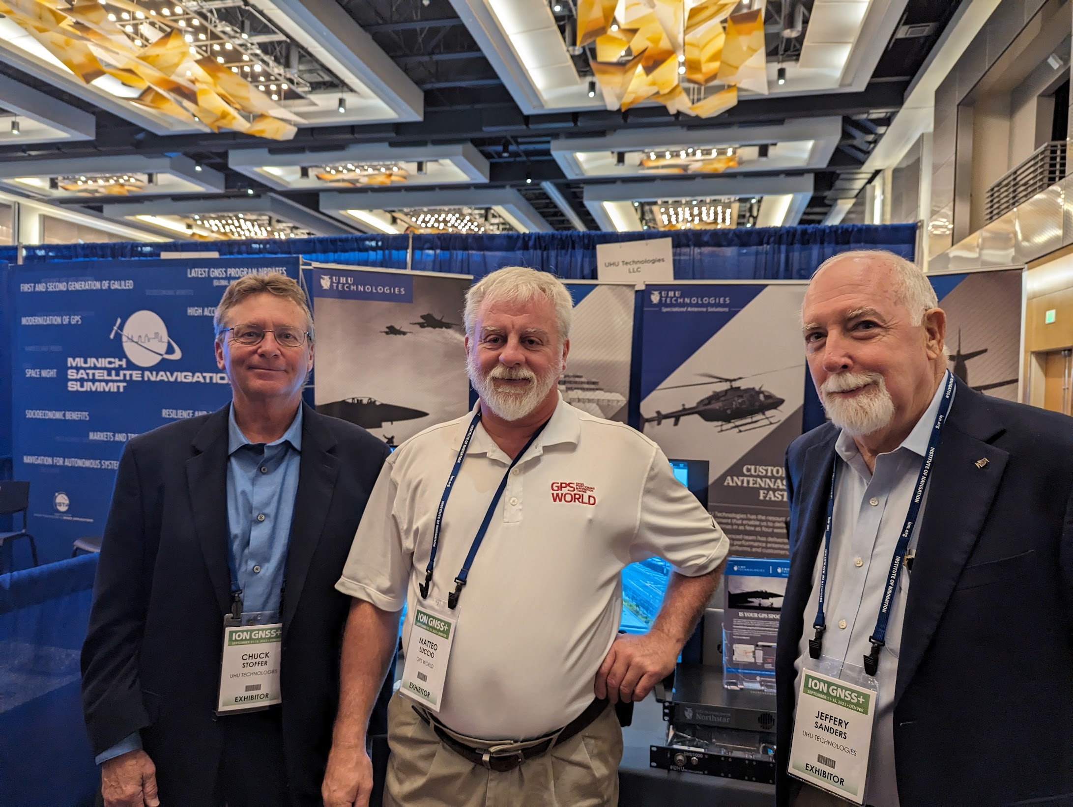 Chuck Stoffer (left) and Jeffery Sanders (right), UHU Technologies.