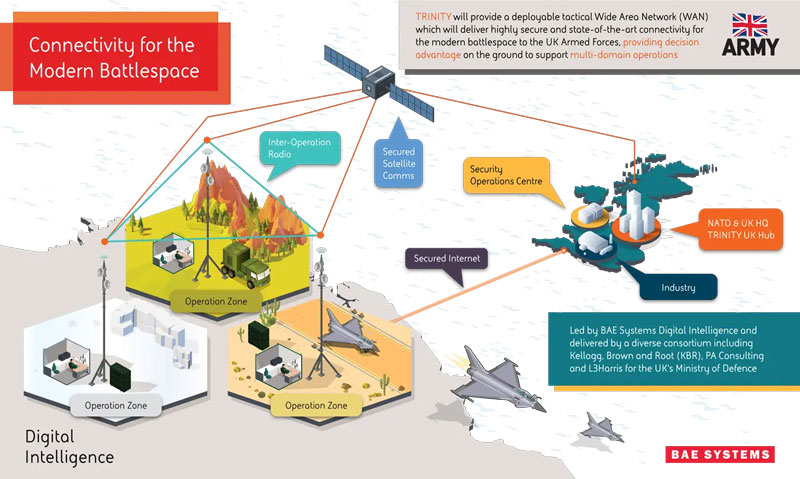
BAE Systems has been awarded an £89 million contract by the Ministry of Defense (MOD) to enhance front-line connectivity for military personnel, UAVs, combat vehicles, fighter jets, aircraft carriers and military commands.
The contract will be dedicated to the research and development phase of BAE Systems’ deployable tactical wide area network (WAN), Trinity. Trinity is due to be delivered in December 2025.
Under the contract, BAE Systems will lead an alliance of trusted partners, including Kellogg, Brown and Root (KBR), PA Consulting and L3Harris, to design and manufacture Trinity. The companies aim to deliver a highly secure battlefield internet capability to UK forces, which will sustain battlefield awareness and intelligence sharing through a myriad of adversarial attacks.
Trinity’s resilience is based on its composition, the company said. It is made up of a series of nodes, each able to add, access and move data in a secure network. If several nodes are damaged in warfare, the remaining automatically re-route to maintain optimum network speed and flow of information.
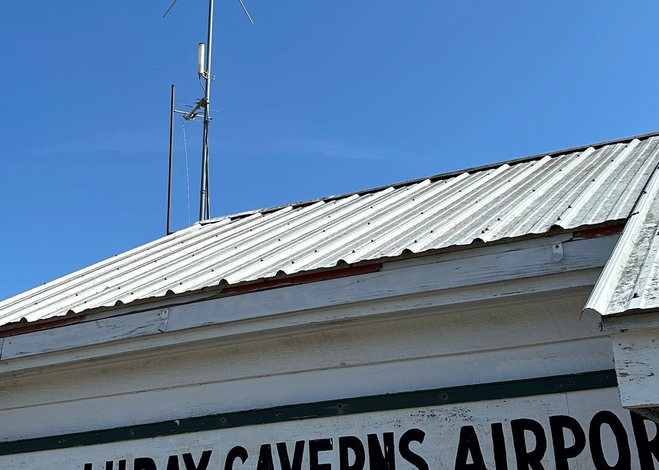
uAvionix has partnered with Civil Air Patrol (CAP) to deploy a DO-260B-compliant, dual-band Automatic Dependent Surveillance-Broadcast (ADS-B) receiver network to complement Federal Aviation Administration (FAA) sensor data with low-altitude aircraft positions in support of CAP’s radar analysis mission.
The ADS-B receiver technology — already in use in Virginia — is designed to shorten the accident-to-rescue time in the National Radar Analysis Team’s search and rescue efforts.
Through the leadership of CAP’s Virginia Wing, members throughout the state have assisted uAvionix in locating suitable receiver sites and supported the installation of small, low-weight FlightStation ADS-B receivers at various airports.
The dual-mode (1090 MHz and 978 MHz) FlightStations receive transponder data from aircraft, which is centrally received and transmitted to the radar team server at Maxwell Air Force Base, Alabama, where it’s combined with FAA sensor data.
The CAP team uses FAA data and advanced technologies in its search and rescue efforts. The team is activated by the Air Force Rescue Coordination Center when there is a report of a possible missing aircraft or crash. Once the team is activated, analysis and actionable data can be provided in minutes to an incident commander, instead of the days or hours required before the team’s creation.
The FlightLine roll-out consists of several ATC grade ADS-B receivers with overlapping coverage, allowing for validation of transmitted ADS-B data and pinpoint multilaterated positions. Traditional ADS-B and radar concentrate mostly on airports and higher altitudes in support of air traffic control.
Most other available data sources largely exclude coverage for 978Mhz transponders, typically used by general aviation aircraft. Virginia is the first state in the U.S. to have complete coverage down to 500 ft of altitude. The new ADS-B is rapidly expanding to other CAP wings across the U.S.
“The introduction of ADS-B has resulted in a significant improvement of general aviation safety,” said Christian Ramsey, managing director, uAvionix. “Expanding on the FAA coverage at lower altitude and for UAT [universal access transceiver] transponders typically carried by general aviation will further enhance the tools used in safety of life activities such as CAP’ ‘s emergency services mission.”
The radar analysis team is calling on all CAP Squadrons to volunteer to host and install additional receivers where additional coverage is needed. Young said his team will prioritize areas where existing coverage is weak.
For more information and to register your squadron for a FlightStation unit, click here.
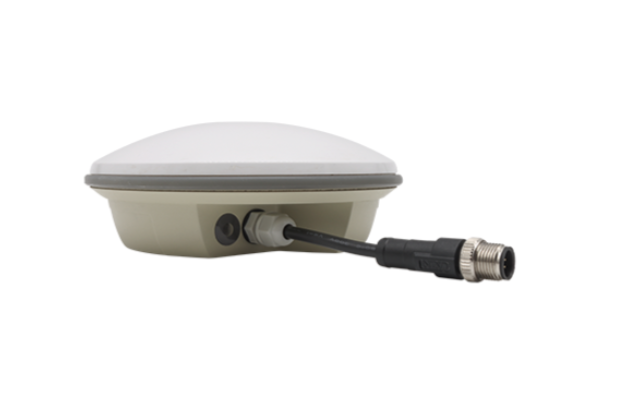
Hemisphere GNSS has released the A631 GNSS smart antenna for agricultural, marine, GIS, mapping and other applications.
The A631 combines Hemisphere’s Athena GNSS engine and Atlas L-band correction technologies with a new web user interface (WebUI). Optional features include 16 GB of internal storage, Bluetooth and Wi-Fi. The compact antenna is designed for rugged environments and meets IP67 requirements.
With multiple operating modes, A631 can be used as an RTK base station or rover. The device is supported by Hemisphere’s Atlas Portal, which empowers users to update firmware and enable functionality, including Atlas subscriptions for accuracies from meter to sub-decimeter levels.
A631 also supports BaseLink and SmartLink modes. SmartLink allows users to directly connect AtlasLink as an extension to any existing system that has industry-standard connectivity options. BaseLink automatically sets up AtlasLink as a permanent reference station, delivering corrections to any other GNSS receiver being used for positioning.
Harxon has launched its TS122 family of smart antennas for demanding precision agriculture applications to increase GNSS availability, accuracy and reliability.
The smart antenna family is designed for high-performance semi-autonomous or autonomous applications that require centimeter-level accuracy – even in highly variable terrain and GNSS-obstructed environments. The TS122 family can be used for agriculture OEMs, integrators that develop precision agriculture solutions, autonomous solution providers and more.
There are two models for the new TS122 smart antenna: EUAA and EUUB. Each model has different performance options to fit users’ individual needs.
TS122 EUAA, with ±10cm P2P accuracy and standalone technology, is best for high-performance semi-autonomous or autonomous applications requiring centimeter-level accuracy, even in challenging GNSS-obstructed environments.
TS122 EUUB has single point 1.5 m circular error probable (CEP) and ±15cm P2P accuracy. Both models support RS-232 serial ports and Bluetooth communication for easy configuration of the smart antenna via users installing a configuration app on a phone or tablets, the company said.
One month after fire blazed through the Greek island of Rhodes in July 2023, more fires have ripped through Greece amid a heatwave in southern Europe, reported the European Space Agency (ESA).
A Copernicus Sentinel-2 image (Figure 1) shows the ongoing blaze near Alexandroupoli in the Evros region of northeast Greece – close to the Türkiye border.
The satellite image is a blend between a natural color and a shortwave infrared composite to highlight the fire front, which was approximately 70 km long as of August 23. The fire has produced a plume of smoke that stretched 1,600 km southwest towards Tunisia. Burned areas can be seen in the image in dark brown.
Figure 1. (Image: ESA)
The Copernicus Sentinel-2 mission is based on a constellation of two identical satellites, each carrying a wide swath high-resolution multispectral imager with 13 spectral bands for monitoring changes in the Earth’s land and vegetation.
In response to the fires, the Copernicus Emergency Mapping Service has been activated in North Attica, Rodopi, Euboea Island, the Sterea Ellada Region, and East Macedonia. The service uses satellite observations to help civil protection authorities and the international humanitarian community respond efficiently to emergencies.
Greece has experienced daily outbreaks of dozens of fires over the past week as gale-force winds and hot, dry summer conditions combined to whip up flames and hamper firefighting efforts. On August 26, firefighters tackled 122 fires, including 75 that broke out in the 24 hours between August 25 and August 26, the fire department (formally the Hellenic Fire Service) said.
Scientists have warned that climate change and land-use changes are projected to make wildfires more frequent and intense. In response, the ESA has reopened its World Fire Atlas, which provides a detailed analysis and map of wildfires across the globe.
The causes of Greece’s two largest fires have not yet been determined. For some of the smaller blazes, officials have said arson or negligence is suspected, and several people have been arrested, reported NBC News.
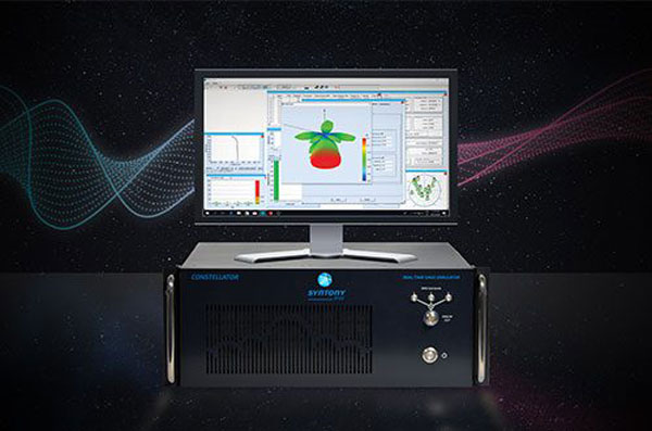
Syntony GNSS has doubled the SDR L1C/A equivalent signals of its multi-GNSS simulation solution, Constellator.
With Constellator’s computation power doubled from 660 L1C/A equivalent signals to 1200, users can simulate a complex RF environment for GNSS testing with a powerful and high-fidelity machine, the company said. Additionally, users can now test equipment with multiple traditional GNSS constellations and new ones to come, such as Xona’s PULSAR.
As a result of doubled computation, massive new constellations can be simulated. When fully deployed, the Xona constellation will count hundreds of satellites on multiple bands, in complex RF environments including specific atmospheric parameters, jamming, spoofing and multipath. It also introduces the controlled reception pattern antenna (CRPA) testing capacities of the device, when the demand is increasing for resilient multi-GNSS and low-Earth orbit (LEO) position, navigation and timing (PNT) solutions.
Syntony said it was the first PNT services provider to integrate all Xona demo signals into Constellator, in 2022. However, to offer a full testing solution, Syntony also developed a Xona-enabled GNSS receiver.
Atmos has integrated the new Sony a6100 Oblique camera into its vertical take-off and landing (VTOL) fixed-wing UAV, the Marlyn Cobalt. The device can be used by professionals in the geospatial mapping and surveying sectors.
The Sony a6100 Oblique camera is an innovative addition to the Marlyn Cobalt because it combines Sony’s 24MP a6100 with a Meike 12mm lens to provide users with a solution for lower-resolution surveying that produces 3D models for urban surveys.
With the integration, the Marlyn Cobalt boasts a 350-hectare coverage at 400 feet, reducing operational time and costs. The resulting ground sampling distance (GSD) of 4cm at that altitude ensures high-resolution data acquisition, delivering detailed images for precise analysis.
The map below (Figure 1) was surveyed by one of Atmos’ customers. The UAV enabled them to identify and inspect the built and natural environment through different processing ways for urban planning in the town of Sancta Maria in the Netherlands.
Figure 1: 3D reconstruction of the Sancta Maria urban area. (Image: Atmos)
To learn more about the integration, visit the Atmos website.
Ukraine’s allies in Europe are sending the country new UAVs and counter-UAV equipment, reported The Defense Post.
German weapons provider Rheinmetall is preparing to send its LUNA NG (next generation) unmanned reconnaissance UAV to Kyiv, the company announced August 14. The system should be delivered by the end of the year, according to Rheinmetall.
The LUNA NG is part of a sizable military aid package for Ukraine initiated by the German government in July. Per Rheinmetall, the package includes a ground control station and several UAVs, as well as a launch catapult, an optional net equipment for catching landing UAVs and equipment for rapid repair. The system is mounted on a Rheinmetall HX truck with a swap body system.
The UAV is designed for a range of mission-specific payloads — including LTE network and electronic warfare support measures such as detection, classification and analysis of electromagnetic radiation for threat detection.
UAV can remain aloft for more than 12 hours and maintain a datalink range of up to 100 kilometers normally, and up to 300 kilometers when fitted with optional satellite communication equipment, according to Rheinmetall.
The Bundeswehr (the German military) has operated LUNA UAV systems since the early 2000s. Those were originally developed by German manufacturer EMT Penzberg, which was acquired by Rheinmetall in 2021.
Berlin has already delivered several reconnaissance UAVs to Ukraine, including 88 Vector UAVs from Quantum Systems, 20 RQ-35 Heidrun systems Sky-Watch, and 32 unspecified reconnaissance UAVs, as of August 9.
Ukraine will also soon receive a series of Cortex Typhon counter-UAV systems made by Norway’s Kongsberg, after the company signed an agreement via the International Fund for Ukraine.
The delivery consists of several Cortex Typhon systems — developed to counter a wide spectrum of UAVs with solutions to either physically harm or disable an aerial threat, Kongsberg said.
The Open Geospatial Consortium (OGC) has released the first iteration the Integrated Geospatial Information Framework (IGIF)-M (Marine) Spatial Data Infrastructure (SDI) Maturity Roadmap for both marine and terrestrial domains.
“The IGIF-MSDI maturity roadmap is an important step that supports a holistic understanding of data-exchange and processing environments,” said OGC Chief Technology Innovation Officer, Ingo Simonis.
According to the OGC, the core of the IGIF-(M)SDI Maturity Roadmap is formed by the World Bank SDI Diagnostic Toolkit where, with contributions from IHO and OGC, its terrestrial heritage was augmented to maximize its benefits to the marine domain.
u-blox has partnered with ORBCOMM, a pioneer in Internet of Things (IoT) technology, to develop solutions for the convergence of terrestrial and satellite IoT communications markets.
According to the Ericsson Mobility Report, the number of cellular IoT connections is projected to reach around 5.5 billion by 2028. The satellite IoT communications market is also expected to triple by 2025. Combining these two technologies will provide gap-free global connectivity for IoT communications, even in previously uncovered areas, making it more accessible for IoT deployers.
With this partnership, u-blox will integrate ORBCOMM’s satellite communication protocols into its UBX-R52/S52 LPWA (low-power wide-area) modem SoC (system-on-a-chip) resulting in a smaller, less complex chipset that offers dual connectivity. This chipset will be used in future u-blox module products, enabling connected solutions across the globe.
The collaboration between ORBCOMM and u-blox will meet the increasing demand for IoT solutions capable of connecting devices in remote locations, areas with poor cellular coverage and isolated environments. Various industrial IoT applications can benefit from these solutions, such as asset tracking, equipment tracking in agriculture and construction industries, and industrial sensors.
“Pairing ORBCOMM’s satellite technology with u-blox’s innovative UBX-R52/S52 chipset will allow customers deploying IoT solutions in the supply chain, heavy equipment, and agriculture industries to benefit from ubiquitous coverage, device simplicity, along with optimal reliability and longevity,” said David Roscoe, ORBCOMM’s executive vice president of satellite communications and products.
“It has been no secret — there are vulnerabilities within the timing and synchronization platforms used by the energy sector,” according to David Wells. Citing well recognized vulnerabilities associated with using signals from GPS, Wells said “…a secure, verifiable, and reliable solution is paramount.”
CAST’s mission is to research, establish and demonstrate best practices for timing within electrical grids.
As part of its efforts, DOE and the Oak Ridge team recently published “Implementing a Terrestrial Timing Solution: Best Practices.” The document is an important complement to the model network CAST has established to demonstrate practices and do further research.
Best practices in the document include discussion of:
equipment needed
various timing sources and transfer methods
the need for environmental stability
IEEE 1588 Precision Time Protocol
hardware recommendations.
Implementing these best practices and establishing timing networks will be up to grid operators as encouraged by DOE’s Power Marketing Administrations.
Others are already taking notice, though.
Concerned about their ability to maintain land mobile radio networks and other applications when GPS is denied or manipulated, the National Guard, in coordination with Homeland Security advisors and emergency managers, has implemented its own terrestrial timing network across the states and territories. The project, Nationwide Integration of Timing Resiliency for Operations (NITRO), has already been implemented in seven states. Major General William Crane, adjutant general for West Virginia, said that NITRO and CAST are well aligned, and the NITRO team will be working with DOE to ensure that continues to be the case going forward.
Pat Diamond, a member of the President’s Space-based Positioning, Navigation, and Timing Advisory Board and a former consultant to CAST, contributed to the development of the best practices. He is also an on-going participant in timing forums such as the ATIS Sync Committee.
When asked for his view he replied “The CAST best practices lay out the how wide area time synchronization networks should be deployed. There needs to be a concerted effort for DOE jointly with the power generating industry to actually implement an end-to-end time synchronization network demonstrating that these best practices are cost effective, manageable and implementable to solve the technical limitations of GPS dependence within a power generating marketplace.”
Inertial Labs has added a new scanning and mapping solution to its Resepi line, the Resepi Teledyne Optech CL-360-HD. The device has a powerful four-return laser and increased range of up to 750 m, making it ideal for mobile mapping, forestry and crack detection in critical infrastructure areas such as airport runways.
Resepi is a sensor-fusion platform designed for accuracy-focused remote sensing applications. Resepi utilizes a high-performance Inertial Labs INS and a high-accuracy dual antenna GNSS receiver, integrated with a Linux-based processing core and data-logging software. The platform also provides a WiFi interface, optional imaging module, and external cellular modem for RTCM corrections. Resepi can be operated by a single hardware button or from a wirelessly connected device via a simple web interface.
Resepi, equipped with Teledyne‘s CL-360HD lidar, offers various laser scan speeds and frequencies, allowing users to tweak the settings to match their individual needs.