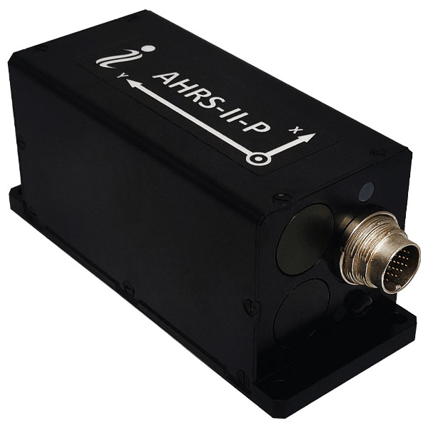
Inertial Labs has released its new attitude and heading reference system, the AHRS-II-P. This device is an enhanced, high-performance strapdown system that determines absolute orientation (heading, pitch and roll) for any mounted device. The AHRS-II-P can determine orientation for both motionless and dynamic applications.
The AHRS-II-P contains a tactical-grade inertial measurement unit (IMU) consisting of three high-precision MEMS accelerometers, three advanced MEMS gyroscopes and a high-precision, gyro-compensated, embedded fluxgate compass. It also uses 8 mm fluxgate magnetometers.
This device is suitable for a variety of devices such as UAVs, antennas, ships and robotic devices.
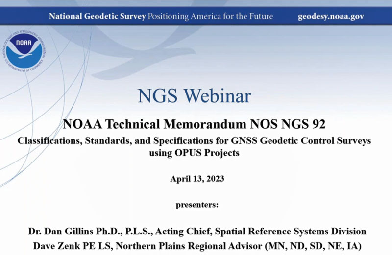
On April 13, the National Geodetic Survey (NGS) held a webinar that described the classifications, accuracy standards and general specifications for GNSS geodetic control surveys using OPUS Projects. The webinar provided a summary of NOAA Technical Memorandum NOS NGS 92, which will be published after it has been through a final review. The presentation can be downloaded here and here. I will highlight some important sections of the webinar, but would also encourage readers to download it and watch it in its entirety.
NGS April 2023 Webinar (Credit: NGS Website)
As described in my March column, OPUS Project 5.1 routine now allows the use of RTN vectors and post-processed vectors from vender software. See my March column or NGS’ January 2023 webinar to learn more about OPUS Project 5.1.
The April webinar described the specifications that are required for GNSS surveys that will be submitted to NGS for publication. It was noted that these specifications are limited to the use of OPUS Project (version 5) for the establishment of North American Datum of 1983 (1983) coordinates and orthometric heights of vertical datums that are part of the current National Spatial Reference System (NSRS). The intent of the NOAA Technical Memorandum NOS NGS 92 is to replace NOAA Technical Memorandum NOS NGS 58 — “Guidelines for Establishing GPS-Derived Ellipsoid Heights, (Standards: 2 cm and 5 cm), Version 4.3” of November 1997, and NOAA Technical Memorandum NOS NGS 59 — “Guidelines for Establishing GPS-Derived Orthometric Heights” of March 2008.
Why replace the guidelines now?
First, there have been improvements in GNSS processing and technology since NOS NGS 58 was published in 1997. The guidelines did not consider the use of real-time kinematic (RTK) technology, the number of NOAA CORS has significantly increased since the 1990s, and NGS’ web-based software OPUS Project 5.1 now allows the use of RTN vectors and post-processed vectors from vender software. In my opinion, there is a difference between guidelines and specifications. Guidelines provide recommended procedures to meet a specific outcome or standard while specifications are an explicit set of requirements that need to be satisfied to meet a specific outcome or standard. In other words, guidelines are general recommendations, and by nature, should be open to interpretation and revised to meet new technological developments.
The webinar described the standards and specifications in 10 tables, which are displayed below. I will highlight a few of these tables that address how RTN vectors and post-processed vectors from vender software can be included in OPUS Project 5.1.
List of Tables:
Classifications of Network and Local Accuracy
Description of Mark Types and Anticipated Usage
Observation Method Requirements for Mark Types
Standards for Observation Requirements by Method
Standards for Network Design
Standards for Monumentation
Standards for Session Processing and Adjustment Results
Standards for Achieving Valid Orthometric Heights
Standards for Equipment Used in Field Observations and Office Procedures
Standards for Required Documentation
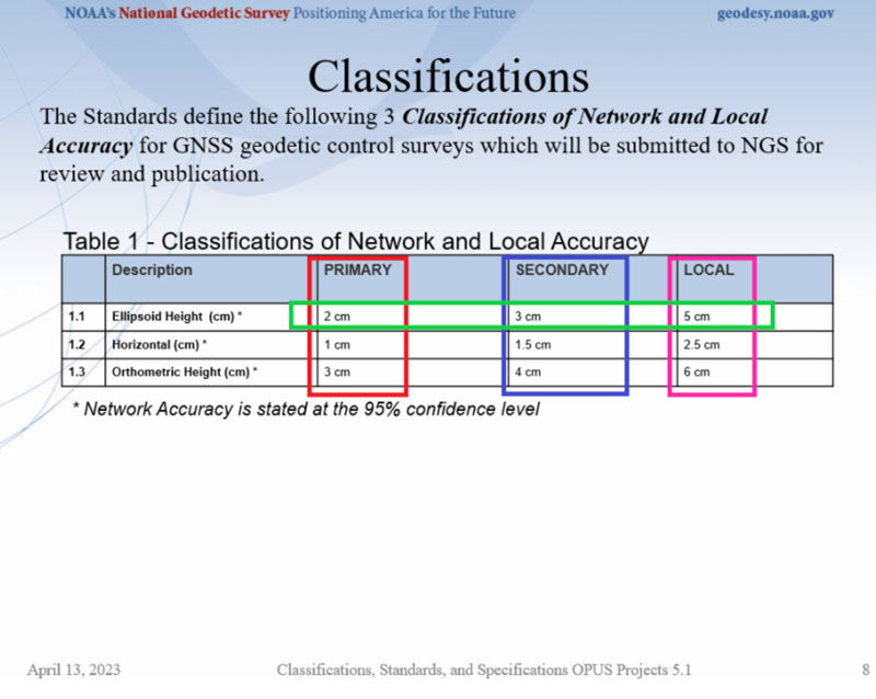
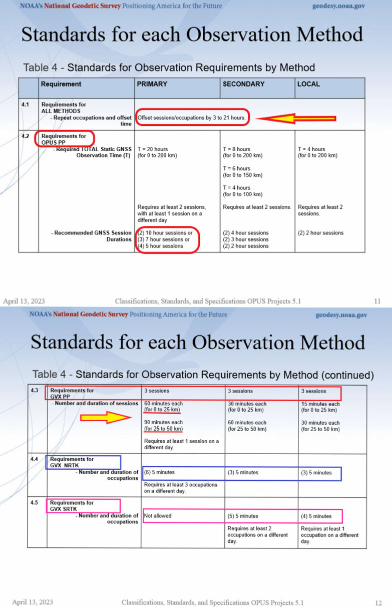
First, NGS has defined three classifications for network and local accuracies in Table 1 — primary, secondary and local. As expected, the accuracy values are different based on the classification. See Table 1. Table 4 provides the observation specifications for each classification.
Table 1. (Credit: NGS Website)
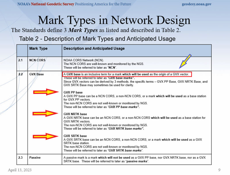
Table 2 provides definitions that are important to understand. NGS designates three different types of marks in the network design — NCN CORS, GVX base, and passive. See Table 2. Each of these types of marks has its own observation requirements which is described in Table 4.
Table 2. (Credit: NGS Website)
Information about the GVX vector format can be obtained here. Basically, the GNSS Vector Exchange provides a standard file format for exchanging GNSS vectors derived from varying GNSS survey methods and manufacturer hardware. NGS’s goal for developing GVX is to make it possible to upload vector data to OPUS-Projects. There are different observation specifications for OPUS Project processing GNSS data and for OPUS Projects accepting GNSS data observed and processed by manufacturer hardware and software — that is GVX data.
Please see my October 2021 column for more information on NGS’s GVX format.
A note on abbreviations: PP stands for post-processed; that is, OPUS PP are baselines processed in OPUS Project. GVX PP are baselines processed using a vendor’s software. GVX NRTK and SRTK are baselines from a vendor’s RTK systems.
Table 4 provides the observation requirements for primary, secondary, and local marks. I have highlighted the following items in that table:
All methods must repeat occupations and repeat sessions/occupations must be offset by 3 to 21 hours.
Required total static GNSS observation time for OPUS PP is greater than total static GNSS observation time for GVX PP data. That said, OPUS PP requires at least two sessions while GVX PP requires at least three sessions.
For GVX PP session, the duration of each session increases with distance and a GVX PP baseline cannot exceed 50 km (this is provided in Table 5:“Standards for Network Design”).
For GVX NRTK, the number of sessions increases to sixfor primary marks, the duration of occupations decreases to 5 minutes, a GVX NRTK baseline cannot exceed 40 km (this is provided in Table 5 – Standards for Network Design), and the mark requires at least three occupations on different days.
The use of GVX SRTK is not permitted for primary marks.
Table 4. (Credit: NGS Website)
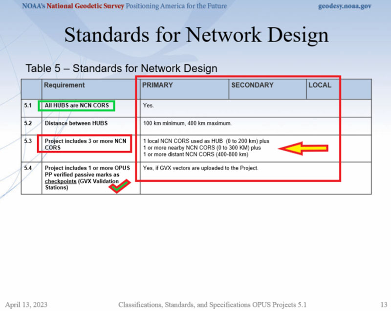
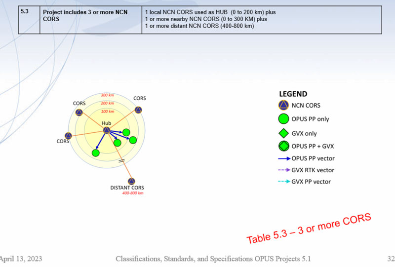
Table 5 provides the specifications for network design; that is, the number of NOAA CORS required and the allowable distance from the HUB CORS. The image titled “Project includes 3 or more NCN CORS” provides a depiction of the specifications.
Table 5. (Credit: NGS Website)
Not all CORS are created equal, so users should evaluate the CORS they plan to include in their GNSS project. My December 2021 column discusses using NGS Map service to evaluate CORS data and plots. Some of the criteria that are used to evaluate CORS include the following: designated as “operational,” computed (measured) velocities rather than modeled (predicted) velocities, “consistent” data depicted in short-term time-series plots, network accuracies ~1 cm to 1.5 cm horizontally and less than ~2 cm to 3 cm in ellipsoid height.
Project includes 3 or more NCN CORS. (Credit: NGS Website)
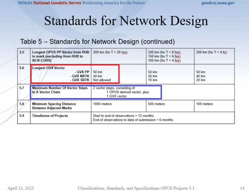
Specifications for GVX vectors are also provided in Table 5. As indicated in Table 5 and previously stated, GVX PP baselines are limited to 50 km and GVX NRTK vectors are limited to 40 km.
Table 5 continued. (Credit: NGS Website)
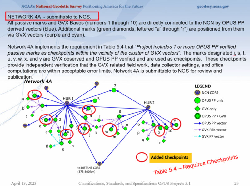
An important specification that needs to be highlighted is that the maximum number of vector steps in a vector chain is two. This means there can only be one OPUS PP plus one GVX vector (either GVX PP or GVX RTK) in a vector chain. This is demonstrated in an example in theimage below.Also, specification 5.4 states that if GVX vectors are uploaded to the project, then a project needs one or more OPUS PP verified passive marks as checkpoints (these are denoted as GVX Validation Stations). The checkpoint marks have been highlighted in the image below as well.
NETWORK 4A – Submittable to NGS. (Credit: NGS Website)
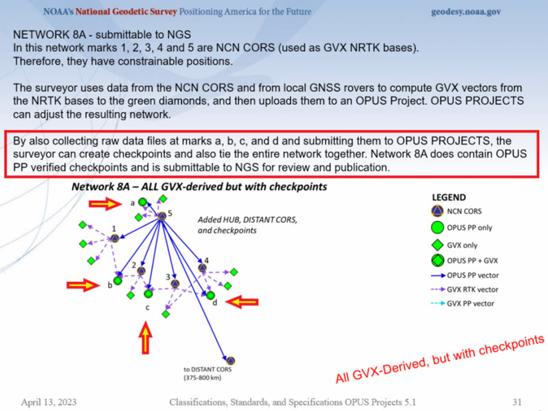
If your state has many CORS with an NRTK, as North Carolina does, then the image below provides an example of how OPUS projects and GVX vectors can be used to efficiently and effectively establish primary control marks.
NETWORK 8A – submittable to NGS (Credit: NGS Website)
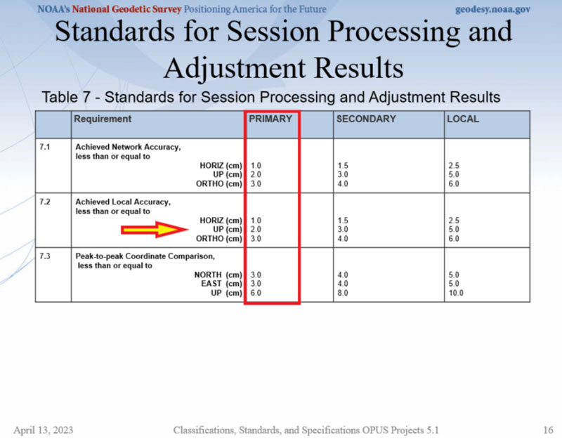
Table 7 provides session processing and adjustment results. The achieved network standard highlighted in the image is the same as the classification standard provided in Table 1, which is what should be expected.
Table 7. (Credit: NGS Website)
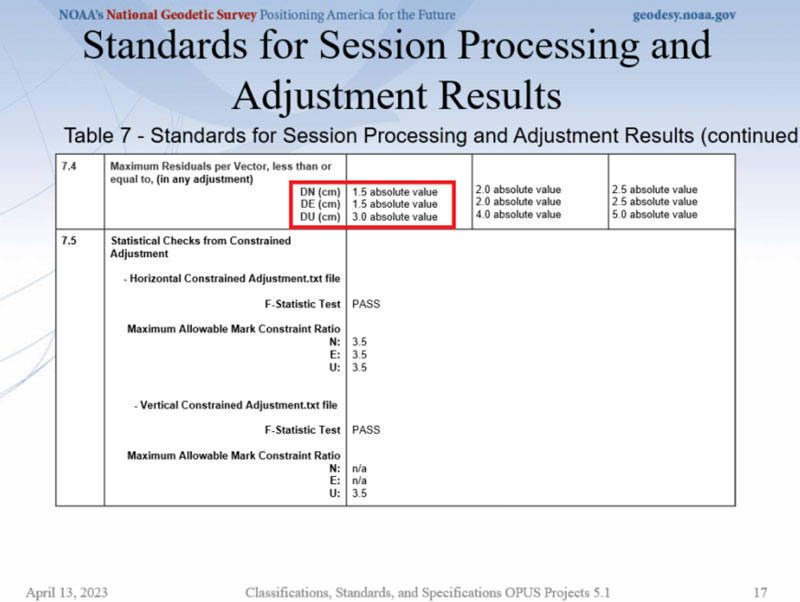
The maximum residual values in dN, dE, and dU are also provided in Table 7. This requirement is important because it helps to ensure that outliers are detected and removed, especially in the height component.
Table 7 continued. (Credit: NGS Website)
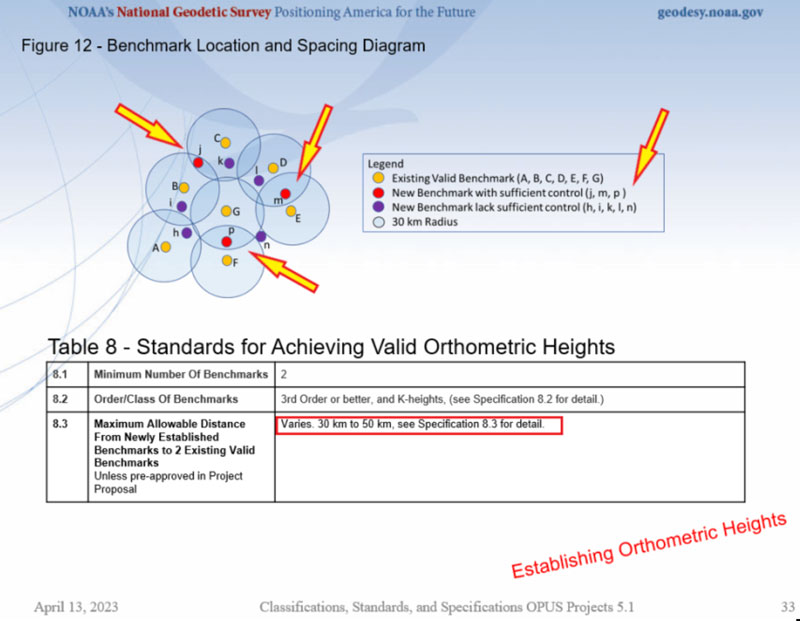
The webinar also had tables and diagrams for establishing orthometric heights. Table 8 and Figure 12 from the webinar provide a summary of the specifications. My January column described the specifications for establishing vertical control in the NSRS in more detail.
Figure 12 from the webinar. (Credit: NGS Website)
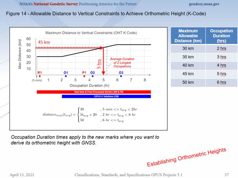
The image below describes specification 8.3 in Table 8. It is important to recognize that the marks that will be used as vertical constraints need to be observed for twoto six hours depending their distance from newly established marks.
Allowable distance to vertical constraints to achieve orthometric height. (Credit: NGS Website)
A lot of information was presented at the webinar and I only highlighted some important sections of it in this column. I would encourage everyone to download the webinar and watch it in its entirety. It should also be noted that NOAA Technical Memorandum NOS NGS 92 is in draft status and is awaiting several final approvals before it is made available for public comment.That said, the webinar’s contents are subject to minor changes as NGS receives feedback. I would encourage everyone to contact the authors with questions and comments.
The Association for Unmanned Vehicles Systems International (AUVSI) has announced the finalists for its sixth annual XCELLENCE Awards. The winners will be announced during an awards ceremony at AUVSI XPONENTIAL 2023 at the Colorado Convention Center in Denver.
The AUVSI XCELLENCE Awards honor innovators who demonstrate commitment to advancing technology, leading and promoting safe operations and developing programs that use unmanned systems to improve the human conditions.
“XCELLENCE IN ACADEMIC RESEARCH”
• Neural10, Autonomous Navigation in GPS-Denied Zones
• Ocean Alliance, Tagging Whales with Drones
• University of Colorado Boulder, 20 Years of UAS Research XCELLENCE
• University of Michigan, Alireza Mohammadi
• Virginia Tech’s Mid-Atlantic Aviation Partnership, Robert Briggs
“XCELLENCE IN INNOVATION”
• Austal USA, Austal MCS
• Plus, PlusDrive, An Industry-defining Driver-in, Highly Automated Driving (HAD) Solution
• Sentera, Eliminating Stitching with the Sentera DGR System
• Skydio, Skydio Dock, Automated Inspections of Sites with Autonomous, Remote Drone Operations
• UPS Flight Forward, Inc., Safety Management System First in the Industry Accepted by the FAA
“XCELLENCE IN OPERATIONS”
Enterprise Application
• Advanced Navigation, Cloud Ground Control
• City of Pendleton, Pendleton UAS Range
• JobsOhio and the Ohio Department of Transportation, Propelling AAM in Ohio
“XCELLENCE IN TECHNOLOGY”
Enabling Components & Peripherals
• Elsight, Elsight Halo
• infiniDome, infiniDome’s GPSdome2
• LEMO Corporation, LEMO M Series High Power
• MatrixSpace, MatrixSpace Networked Radar
• SBG Systems, Quanta Micro
• Advanced Navigation, Cloud Ground Control
• AlarisPro, Inc., AlarisPro Safety Ecosystem (ASE) – Advancing UAS Reliability Through Shared Data Across UAS Operators and Manufacturers
• BlueSpace.ai, Scalable and Explainable AI for Autonomy, powered by 4D Predictive Perception
• Skydio, Skydio Scout, Situational Awareness for Moving Convoys
• VOTIX, VOTIX
“XCELLENCE IN WORKFORCE DEVELOPMENT”
• DroneUp, with partner, Richard Bland College, Established the First Commercial Drone Workforce Training Program for College Credit
• Embry-Riddle Aeronautical University Worldwide and Warren College, Better Together: Producing Effective Educational Opportunities for the UAS Workforce
• Fullerton College, Fullerton Drone Lab, Drone Piloting Registered Apprenticeship
• Laurel Ridge Community College, Laurels Take Flight
• National Robotics Education Foundation NREF, National Robotics Education Foundation (NREF)
“XCELLENCE IN MISSION”
Humanitarian Project or Program
• ArroTech, Rapid and Accurate Autonomous UXO Detection
• MissionGO, Inc., Operation Healing Eagle Feather
• Near Earth Autonomy, Autonomous Aerial Blood & Medical Supply Delivery to the Wounded
• The David McAntony Gibson Foundation (GlobalMedic), GlobalMedic RescUAV Response to La Soufrière Volcano in Saint Vincent and the Grenadines
• UCAL Fuel Systems Limited, Drone Based Disaster Relief
Public Safety
• Brookhaven GA Police Department, Brookhaven Police sUAS Team
• DRONERESPONDERS, DRONERESPONDERS Public Safety Alliance
• Hidden Level, Inc., Airspace Monitoring Service (AMS)
• Texas Department of Public Safety, Texas Department of Public Safety
• United States Forest Service, Testing and Scaling New Technologies for Operations and Safer Mixed Airspace Ops
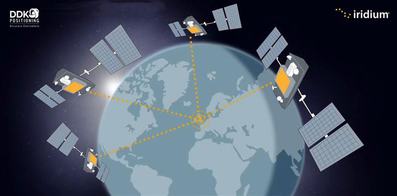
Topcon Positioning Systems has made an investment in DDK Positioning, a UK-based GNSS receiver and precise point positioning correction services company. DDK Positioning delivers services over the Iridium network to provide global precision positioning services that can augment GNSS constellations enhancing accuracy for critical industrial applications.
“With the expansion and growing success of this business, specifically in the marine sector, a closer cooperation will ensure optimal integration for the highest possible accuracies and performance in the most demanding applications,” Ian Stilgoe, vice president of Emerging Business at Topcon, said.
“This partnership provides an extraordinary opportunity for our two companies to work together in pursuit of our shared ambition — providing a robust, resilient and truly unique GNSS positioning service,” Kevin Gaffney, CEO of DDK Positioning, stated.
Drone Safety Day (DSD) is returning for its fifth consecutive year on April 29. The annual campaign, designed by the Federal Aviation Administration (FAA), is dedicated to educating the drone community on the importance of flying safely.
The event will highlight the societal, economic, and safety benefits of safe drone operations. DSD will feature in-person, virtual and hybrid events in areas such as education, economics, equity, environment and emergencies.
DSD provides opportunities for businesses, schools and organizations to share how they use drones, as well as kick off new safety initiatives. The 2023 campaign encourages drone pilots and recreational flyers to “Fly RIGHT” by focusing on five safety elements:
Register your drone
Interact with others
Gain knowledge
Have a safety plan
TRUST and Train
A full list of events and registration can be found on the FAA website.
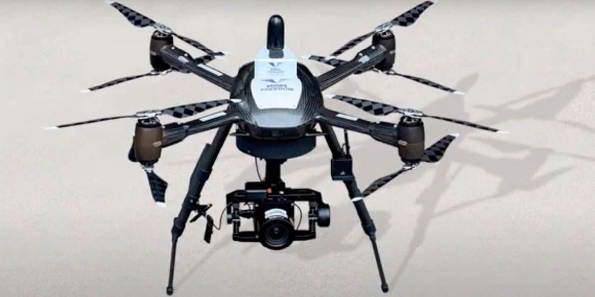
Plowman Craven, a United Kingdom-based aerial surveying company, has launched the Vogel Freedom UAV data collection solution designed for owners and operators of rail networks.
The Vogel Freedom UAV solution aims to solve issues rail operators face in carrying out network surveys, including traffic disruptions and dangers created for workers needing access to infrastructure for ground point sensors.
The platform requires fewer ground points to deliver topographical surveys. It can also produce sub-5 mm accurate rail system models using off-track sensor placement.
Operating from offices in London and Hertfordshire, Plowman and Craven is one of the largest infrastructure surveying and inspection businesses in the U.K.
“We developed Vogel Freedom in response to ever-increasing industry challenges and needs,” Steve Jones, head of new business at Plowman Craven, said. “It removes previous limitations to surveying and can add substantial value… all while improving workers’ safety and ensuring a safe and efficient rail service for customers.”
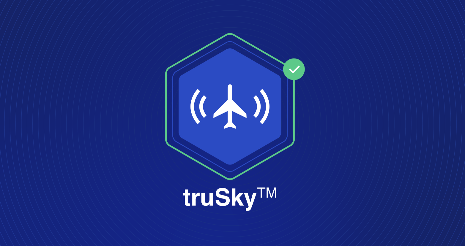
uAvionix has introduced truSky ADS-B spoofing detection for its SkyLine uncrewed aircraft system (UAS) beyond visual line of sight (BVLOS) services.
The uAvionix truSky validation process uses a network of low-profile deployed dual-frequency ADS-B ground receivers to evaluate each signal transmitted from the aircraft. The system then compares the received signals to confirm that the signal originated from the aircraft’s position.
When used within the uAvionix SkyLine platform, each aircraft track point is color-coded based on its confidence score. The validation score is then transmitted along with the position updates of the aircraft using SkyLine API.
TruSky is being piloted in numerous locations in the United States and is available as a component of uAvionix’s SkyLine UAS BVLOS service or as an API for integration into uas GCS, UTM, or ATM platforms.
“Since February 2022, there has been an increase in jamming and/or possible spoofing of GNSS. This issue particularly affects the geographical areas surrounding conflict zones but is also present in the eastern Mediterranean, Baltic Sea and Arctic area,” the European Union Aviation Safety Agency stated in a Feb. 17 safety information bulletin.
On April 4, the United Kingdom’s Civil Aviation Authority followed with its own advisory adding that, in addition to the year-over-year increase, interference has intensified in recent months citing the same geographic areas of concern.
Both advisories list impacts to aircraft that include:
loss of ability to use GNSS for waypoint navigation
loss of area navigation (RNAV) approach capability
inability to conduct or maintain Required Navigation Performance (RNP) operations, including RNP and RNP Authorization Required (RNP AR) approaches
triggering of terrain warnings, possibly with pull up commands
inconsistent aircraft position on the navigation display
loss of automatic dependent surveillance-broadcast (ADS-B), wind shear, terrain and surface functionalities
failure or degradation of a variety of air traffic management service and aircraft systems that use GNSS as a time reference
potential airspace infringements and/or route deviations due to GNSS degradation.
Airspace infringement can be a real concern, especially in conflict zones or near belligerent nations.
GPS was first authorized for civil use because of just such an incident. In 1983, a Korean airliner accidentally trespassed into Soviet airspace and was shot down. Despite the fact that the GPS constellation had not yet been declared fully operational, in September of that year President Ronald Regan authorized its use in civil applications to help avoid similar tragedies in the future.
GPS-based navigation for aircraft was subsequently found to be so efficient and successful that the Federal Aviation Administration (FAA) planned to eliminate all the terrestrial navigation beacons it maintains for air traffic and rely entirely upon GPS. Despite a 2001 report from the U.S. Department of Transportation’s Volpe Center cautioning against such an action, this plan was not abandoned until several years later when an aircraft crossing the Atlantic lost GPS reception.
In recent years, aviation industry concerns about interference with GPS and other GNSS signals have intensified. These concerns have even included planned and announced military exercises that cause interference. Aviation industry groups have complained that the exercises disrupt and are too costly to their operations.
Safety of life has also been a concern.
In 2019 a commercial passenger aircraft was nearly lost to GPS interference in Sun Valley, Idaho. Flying a GPS-based approach through the mountains to the airport, low-level interference caused the aircraft to deviate from its course. In the words of the safety report filed with NASA, had a sharp-eyed radar controller hundreds of miles away not spotted the problem and intervened, “…that flight crew and the passengers would be dead, I have no doubt.”
This incident was cited by the International Air Transport Association (IATA) in a filing later that year urging international action. Along with other groups, it pressed the U.N.’s International Civil Aviation Organization (ICAO) concerning “An Urgent Need to Address Harmful Interferences with GNSS.” In 2020, ICAO issued a letter to all member states recommending action.
Similar concerns have been expressed by other international bodies as well.
In 2021 a EUROCONTROL seminar said that there had been a 2,000% increase in GNSS RFI incidents since 2018 as measured by voluntary incident reporting. Also, that 38.5% of European en-route traffic operated in regions regularly affected by interference.
The International Telecommunications Union, the U.N. body responsible for coordinating spectrum use, issued its own concern and warning in 2022. It cited more than 10,000 aviation-related incidents the previous year and, like ICAO, urged member states to take action to prevent such occurrences.
While interference with GNSS signals is unquestionably a concern for commercial aircraft, it is perhaps even more of a safety risk for smaller, general aviation users.
The only electronic navigation aids in many of these aircraft are consumer-grade GPS receivers. Since these are not certified by the FAA, they are only officially authorized for use to help pilots maintain “situational awareness” while they fly using visual reference with the ground. Interference with GNSS signals can cause disorientation and could result in aircraft becoming lost, running out of fuel, or straying into prohibited areas.
Bluesky International and SkyFi have collaborated to provide access to Earth observation assets and multi-perspective imagery to users globally. Bluesky is providing its high-resolution aerial imagery, taken by aircraft-mounted cameras, to SkyFi to make available for businesses, forestry, water and land managers across the United Kingdom.
SkyFi aims to make Earth observation data more accessible to users through its growing network of satellites and aerial platforms. The company has created a data marketplace where users can purchase existing images or task a satellite to purchase a new image.
Bluesky provides a wide range of geospatial data products and services to users across the United Kingdom. GIS and CAD-ready imagery from Bluesky captures ground terrain, cityscape rooftops, fauna and more. The company’s catalogue of aerial imagery is available in England, Scotland, Wales and the Republic of Ireland.
The European Space Agency (ESA) Academy is requesting university students to apply for the pilot edition of the Navigation Training Course. The course will take place June 26-30 at ESA Academy’s Training and Learning Facility in ESEC-Galaxia, Belgium.
With a specific focus on Galileo, the ESA Academy course aims to provide university students with an introduction to satellite navigation. Designed by ESA experts that developed the Galileo space and ground segment, this training course will offer students fundamental knowledge of Galileo’s architecture, tools, services and functionalities.
The training course will include lectures and hands-on exercises with a tour of Galileo in-orbit test facilities in ESEC, which provides an essential part of the current Galileo ground segment.
Upon completion of the training course, students will be evaluated and will receive a certificate of participation and course transcript, allowing them to request ECTS credits from their respective universities.
For more information and application requirements, visit the ESA website.
Atmos — a Dutch UAV manufacturer that develops vertical take-off and landing (VTOL) fixed-wing UAVs for mapping and surveying applications — expanded its global reseller network by signing an agreement with Topcon Solutions. Topcon will be responsible for the distribution of Marlyn Cobalt UAVs in the United States and will provide assistance and maintenance services to local UAV operators.
The Marlyn Cobalt is a VTOL fixed-wing mapping UAV developed by Atmos and enables users to collect accurate geospatial information and turn it into actionable insights.
Atmos has integrated the Sony a7R mark III and IV cameras into the Marlyn Cobalt to increase the coverage and accuracy achieved in a single flight for surveyors. When combined with Zeiss’ 35 mm and 21 mm lenses, UAV surveyors can achieve ground sample distance levels of less than 1 cm. The integration of the two cameras enables Marlyn Cobalt users to map an area of 210 ha with centimeter-level accuracy in a single flight.
On March 20, 2023, I wrote a short announcement about a funding opportunity by the National Geodetic Survey (NGS) to support the science of geodesy.
As mentioned in previous columns, Everett Hinkley wrote about the geodesy crisis in an ION article. Hinkley’s article summarized several action items that could help improve the lack of trained geodesists in the United States. One action was to encourage U.S. government support in the form of grants, professional development of staff, and research collaborations/affiliations. A pilot PhD geodesy educational program with three National Geospatial-Intelligence Agency (NGA) and one NGS employee is in place. He stated that the NGA expects to continue growing this program. Click here for more information on NGA’s academic research program.
NGS’ geospatial modeling grant is another example of this action item. There needs to be more funds added to this task, but it is a start. The program priorities under NGS’ grant program include: research and develop new methodologies for defining and applications for working with the NSRS; develop and evaluate tools, models, and guidelines to access, analyze, and manipulate geodetic data; enhance infrastructure of geodetic control, coastal remote sensing data, survey measurements, and other physical datasets that comprise the NSRS; support education, capacity building, and technology transfer for the future of geodesy; coordinate through partnerships with local, state, and regional users such as state and local governments, universities, and/or the public sector.
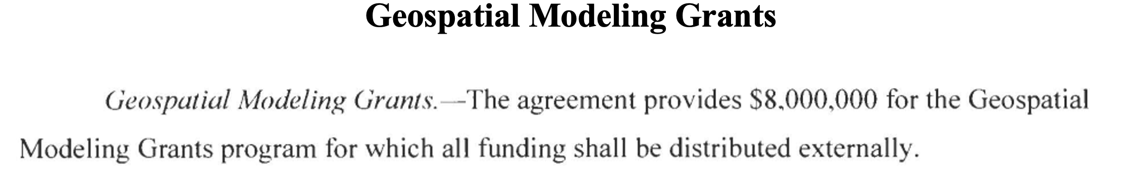
The geospatial modeling grant was included in the 2023 Omnibus Appropriations Bill. The agreement provides $8,000,000 for the program and states that all funding shall be distributed externally. Hopefully, the same amount or more will be in FY 24 appropriations. Additional information about NOAA’s appropriations can be found in the 2023 Omnibus Appropriation Bill under the explanatory statement for Commerce, Justice, Science and related agencies. The bill can be found here. To find the language in the bill click here, then search the document for “geospatial.” See the image below for the language in the bill.
Image: Senate.gov website
For those that are interested in the appropriation process, the image below provides a list of the senators that work on these agencies’ appropriations. If you are interested in learning more about the appropriation process and the geospatial modeling grants, contact your senator. The more congressional representatives know about the geodesy crisis — which includes the lack of trained geodesist as well as surveyors — the sooner they will support funds to help correct the problem. Click here for a list of senators on the Commerce, Justice, Science and Related Agencies Appropriation Committee.
Advancing geodesy with conferences
Another activity that promotes the advancement of geodesy and surveying are national and international surveying and mapping conferences. Before the American Congress on Surveying and Mapping (ACSM) disbanded, the four-member organization collaborated to convene annual surveying and mapping conferences in the United States. Topics like those presented at a FIG Working Week were presented at these conferences.
Since these ACSM conferences are no longer being held, I encourage users of geospatial data and GNSS technology to attend conferences like FIG Working Week 2023. I have participated in several FIG meetings and learned a lot from presentations as well as holding hallway meetings with experts from the international surveying and mapping community. In the March column, I highlighted that FIG Working Week 2023 is going to be held in Orlando, Florida, on May 28 – June 1. NGS will be presenting a full-day worth of content on NSRS modernization during the conference. I want to highlight some presentations that may be of interest to readers. Register for FIG Working Week 2023 here.
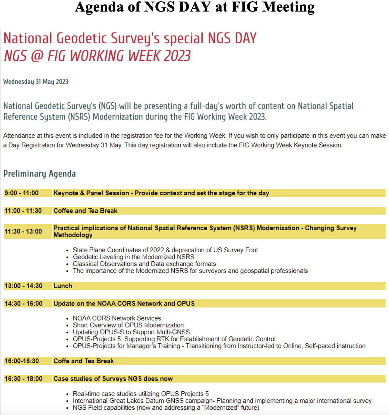
The image below provides a list of NGS presentations with scheduled times. There will be a panel session in the beginning of the day to set the context for the day.
Agenda of NGS DAY at FIG Meeting (Image: FIG website)
As in most conferences there are several ways participants can register, one day to the entire conference. This is a great opportunity to have discussions with the leadership of the National Geodetic Survey and individuals working on the development of the new, modernized NSRS.
Image: FIG website
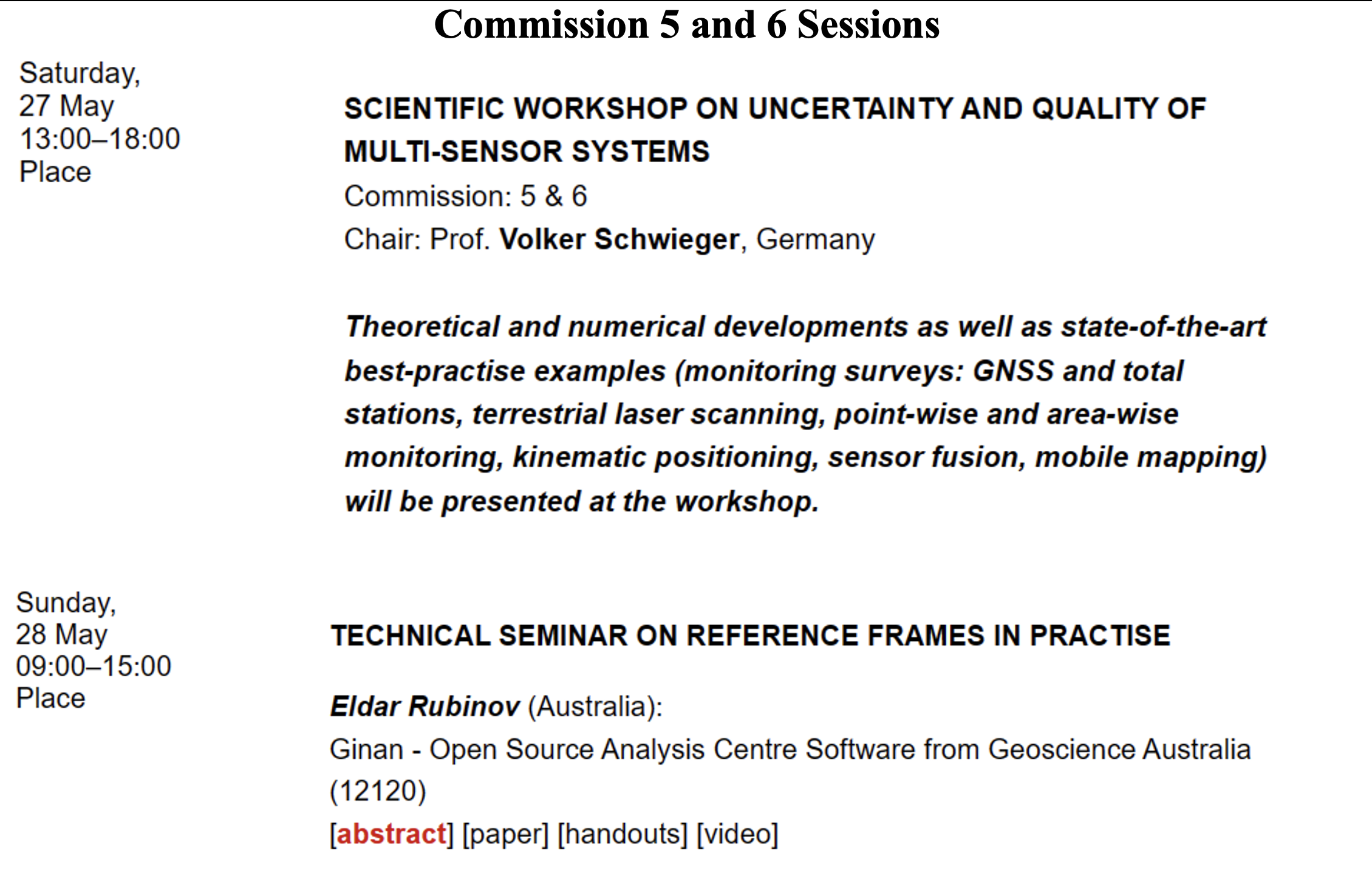
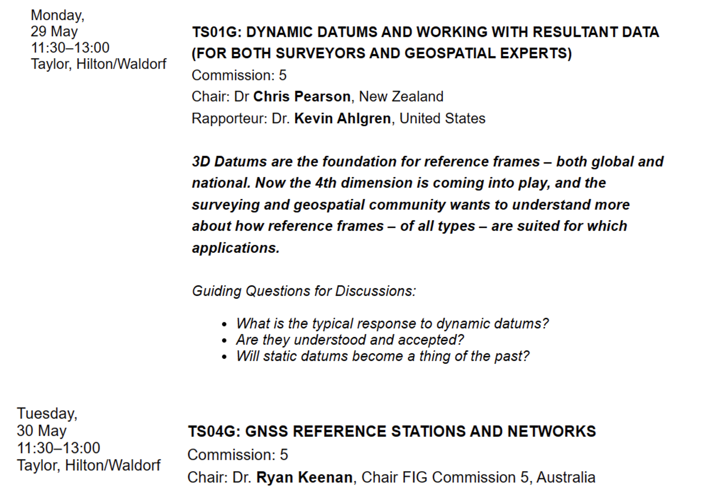
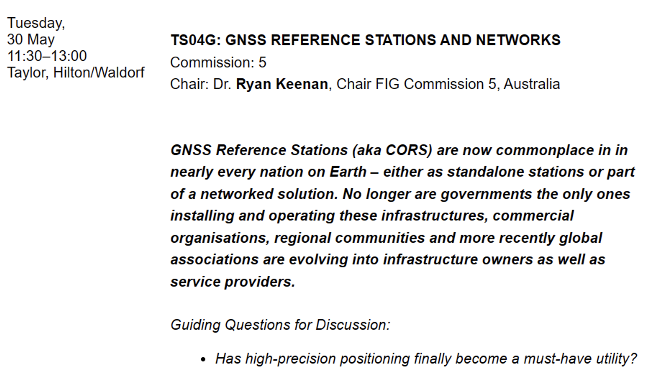
There are a lot of presentations on various topics so, I would encourage readers to look through the entire agenda. FIG’s technical work is led by ten commissions. The August 2021 column provided information about the FIG commissions. See the list of commission below:
Commission 1 – Professional Standards and Practice Commission 2 – Professional Education Commission 3 – Spatial Information Management Commission 4 – Hydrography Commission 5 – Positioning and Measurement Commission 6 – Engineering Surveys Commission 7 – Cadastre and Land Management Commission 8 – Spatial Planning and Development Commission 9 – Valuation and the Management of Real Estate Commission 10 – Construction Economics and Management
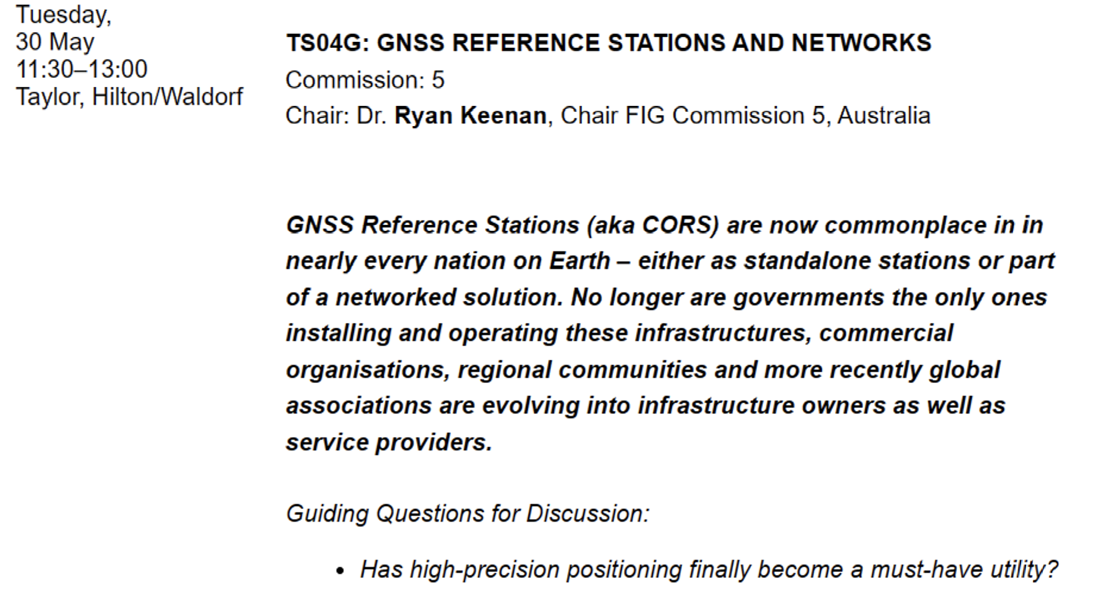
The full technical program lists the topics by date and time. I highlighted sessions by commission 5 and 6 that I think would be interested to the surveying and mapping community. See the image below.
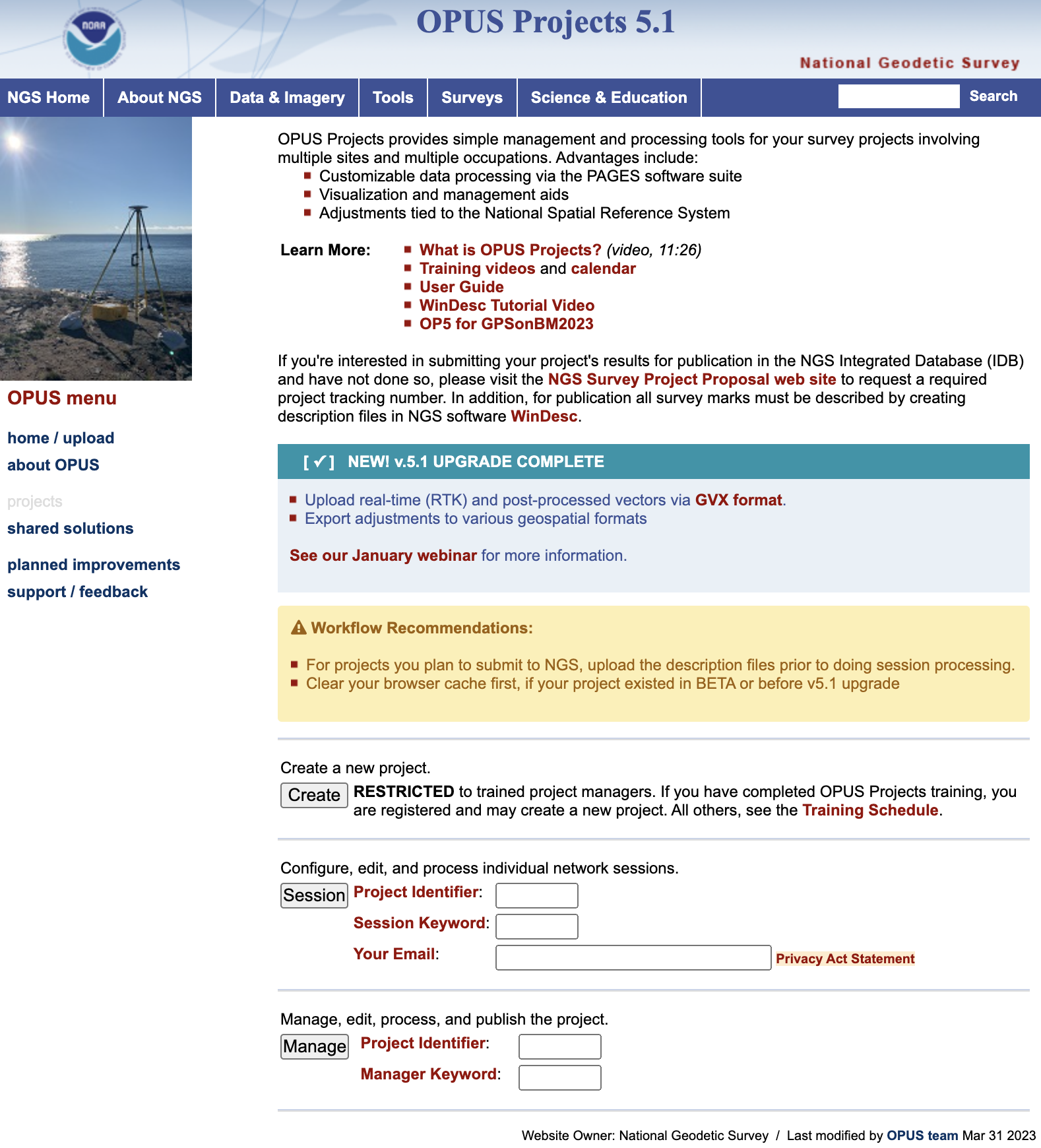
Finally, I would like to highlight a NGS product that is now in production mode. That is, OPUS Project 5.1 is now a production product. *NGS did not make an official announcement about this change, but if you access OPUS Project the new version comes up. As described in the March column, OPUS Project 5.1 routine allows the use of RTN vectors and post-processed vectors from vender software.
Clicking the “projects” icon on the OPUS page connects you to the latest version of OPUS Project 5.1. See image below. Please see the March column or NGS’ January webinar to learn more about OPUS Project 5.1.
Image: NGS Website
*Note: As of the writing of this column, March 29, it is still listed on the beta release section of NGS website. If you click on OPUS Project 5.1 in the Beta Release section, it will link to the production version of the routine.