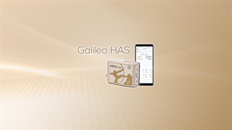
Eos Positioning Systems has released its Arrow Gold+ GNSS receiver, which supports the Galileo high-accuracy service (HAS). Arrow Gold+ enables users to achieve better than 20 cm accuracy with 95% confidence using Galileo HAS.
The Arrow Gold+ is one of the first high-accuracy GNSS receivers that supports Galileo HAS and is designed specifically for the geographic information systems market. Additional signal support for Arrow Gold+ includes: the concurrent use of the BeiDou B3 and GPS L5 signals as well as GLONASS, BeiDou, QZSS and IRNSS signals.
Galileo HAS is a differential correction service from the European Space Agency and European Union Agency for the Space Programme. The service became available on January 24, and it is the first global differential correction service to provide sub-meter accuracy to compatible GNSS receivers anywhere in the world.
For more information on the Arrow Gold+ click here.
Some airlines and military aircraft, including the Australian commercial airline Qantas, are receiving radio interference and GPS jamming from alleged Chinese warships in the Asia Pacific, report Australia Aviation and The Guardian.
The International Federation of Air Line Pilots’ Associations (IFALPA) released a statement acknowledging the reports of interference and recommended that pilots carry on, not respond to the warships and report all incidents to air traffic control.
“IFALPA has been made aware of some airlines and military aircraft being called over 121.50 or 123.45 by military warships in the Pacific region, notably South China Sea, Philippine Sea, East of Indian Ocean. In some cases, the flights were provided vectors to avoid the airspace over the warship. We have reason to believe there may be interferences to GNSS and RADALT as well,” the statement noted.
Further recommendations from IFALPA include notifying company dispatchers of the attempted contact and completing an ASAP report or other company safety report for non-ATC communication or GNSS interference.
A roundup of recent products in the GNSS and inertial positioning industry from the March 2023 issue of GPS World magazine.
UAV
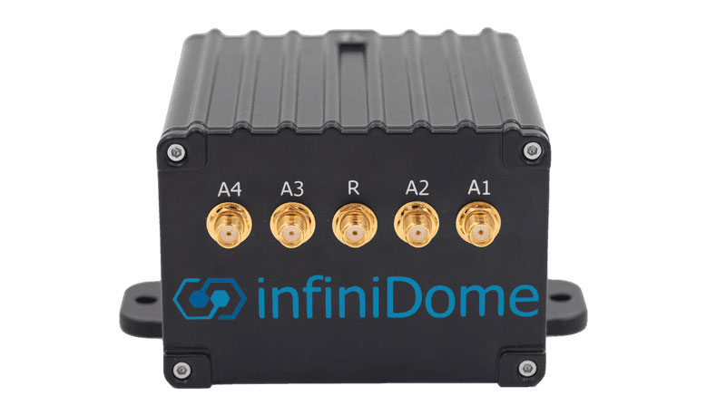
Image: InfiniDome
Anti-Jamming Device Provides protection from three directions of attack
The GPSdome 2 is tailored to defend small- to medium-sized tactical UAVs as well as manned and unmanned ground vehicles. With a small form factor (500 g, 87 mm x 91 mm x 61.55 mm) and minimal power consumption, GPSdome 2 is suitable for loitering munitions as well as UAVs. Fully retrofit and completely standalone, the system is compatible with almost any off-the-shelf GNSS receiver as well as standard active GNSS antennas, meaning that it can be integrated into existing GPS systems or into new product lines, manned or unmanned. With sophisticated algorithms and a proprietary RFIC, GPSdome 2 analyzes RF interference in the environment and combines multiple antenna patterns to create and dynamically steer three nulls in the direction of any hostile signal. GPSdome 2 provides simultaneous dual-frequency protection (GPS L1 + L2 or GPS L1 + GLONASS G1), creating up to three nulls, protecting from three jamming directions within each band in real time, making it suitable for PNT applications. The GPSdome 2 is a dual-use, non-ITAR device and comes with optional mil-spec compliance. InfiniDome, infinidome.com
Image: uAvionix
Command and Control Designed for easy integration
The SkyLine C2 management platform and muLTElink airborne radio systems (ARS) are designed to integrate, which enables a self-healing command-and-control network capable of both path and link diversity. This eliminates lost-link possibilities over broad terrain and altitude ranges. MuLTElink ARS consists of two models — muLTElink915 and muLTElink5060, the core of the uAvionix C2 system. The muLTElink915 model combines globally licensed aviation LTE, enhanced with frequency hopping 902 MHz – 928 MHz industrial, scientific and medical frequencies capability. The muLTElink5060 model combines global LTE with aviation-protected 5,030 MHz – 5,091 MHz C-band. Each muLTElink model allows up to one external CNPC radio to be optionally connected to allow simultaneous use of all three frequency ranges, higher power C-band operation or future radio integrations. uAvionix, uAvionix.com
Image: Atmos
VTOL UAV With Sony a7R mark III and IV camera
Atmos has integrated the Sony a7R mark III and IV cameras into its vertical take-off and landing (VTOL) fixed-wing UAV, the Marlyn Cobalt. This will increase coverage and accuracy achieved in a single flight for surveyors. Both cameras have an ISO of 32,000, which is expandable to 102,400, and camera sensors with high megapixel count — 42,4 MP for the a7R III and 61 MP for the a7R IV. When combined with Zeiss’ 35 mm and 21 mm lenses, it enables UAV surveyors to achieve ground sample distance levels below one 1 cm. The integration of the two cameras enables Marlyn Cobalt users to map an area of 210 ha with centimeter-level accuracy in a single flight. Atmos, atmosuav.com
UAV and Lidar Systems Suitable for geospatial professionals
TrueView 535 consists of updated lidar sensors, adding a third return, increasing mapping abilities below canopy. An additional third nadir camera offers another point of view and improves photogrammetry quality. It also includes a longer, usable lidar range to increase flexibility. TrueView 720 is a fourth-generation Riegl VUX-120 with three laser beam orientations. It provides high-point density corridor mapping. Using the Riegl VUX-120 with three laser beam orientations (nadir, +10 degrees forward and –10 degrees backward) and three oblique/nadir cameras enables data collection from more surfaces in one flight path. One application of TrueView 720 is scanning power lines. Users can capture the poles vertically, front and back. The extreme range of this system means it can be integrated with UAVs, airplanes or helicopters. In addition to the two sensor payloads, GeoCue has launched its LP360 software add-on for processing and visualization — the 3D Accuracy and the Accuracy Star hardware.
GeoCue, geocue.com
OEM
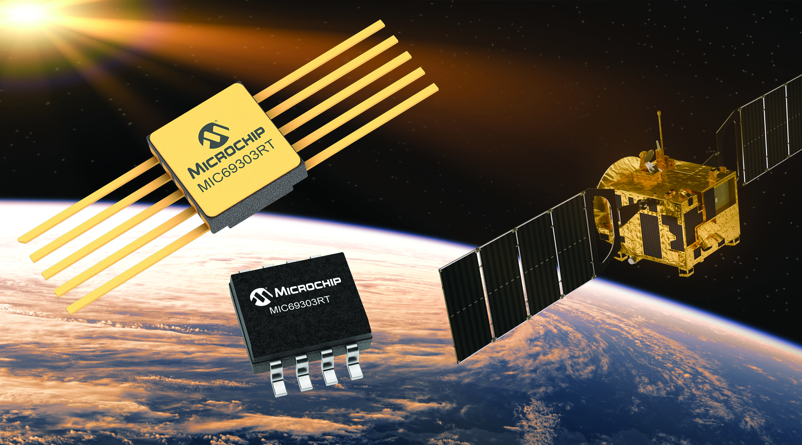
Image: Microchip
Voltage Regulator Device for LEO space application
The MIC69303RT is a radiation-tolerant power management device for space application developers. It is a high-current, low-voltage device targeting low-Earth orbit space applications. The MIC69303RT operates from a single low-voltage supply of 1.65 v to 5.5 v and can supply output voltages as low as 0.5 v at high currents. It offers high-precision and low dropout voltages of 500 mv under extreme conditions. The MIC69303RT is a companion power source solution for microcontrollers, such as the SAM71Q21RT and PolarFire field-programmable gate arrays. MIC69303RT is designed for harsh aerospace applications and remains operational in temperature ranges from -55 C to +125 C. Microchip Technology, microchip.com
Image: Spirent Communications
LEO Satellite Device Designed for GNSS/PNT lab testing
SimORBIT is a low-Earth-orbit (LEO) satellite solution software designed to aid developers in determining LEO orbits more accurately for GNSS/PNT lab testing. The software replicates LEO orbits so that simulations can provide the realistic environment of a LEO satellite, including gravitational and atmospheric impacts the satellite could encounter in space. Developers can create non-ICD signals via I/Q injection, or by the “Flex” feature, generating space-centered PNT signals to be developed in the lab as realistically as possible. Spirent Communications developed SimORBIT in partnership with SpacePNT. Spirent Communications, spirent.com
Image: Sony
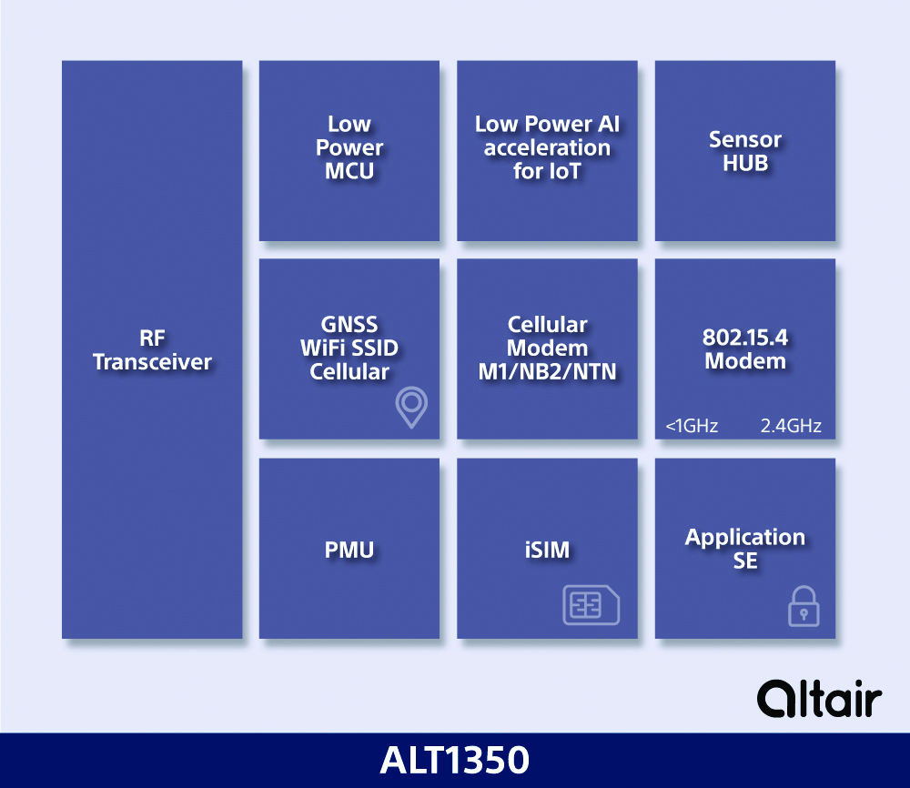
5G Chipset Includes GNSS
The ALT1350 implements GNSS, cellular and Wi-Fi-based location in a single chipset. The cellular LTE-M/NB-IoT chipset is designed to enable additional low-power, wide-area (LPWA) communication protocols; intermittent LTE and GNSS (GPS/GLONASS) navigation for low-cost applications; and concurrent LTE and L1/L5 GNSS for tracking applications. The ALT1350 incorporates a sensor hub to collect data from the sensors while maintaining ultra-low power consumption. It also provides cellular and Wi-Fi-based positioning and is tightly integrated to provide power-optimized concurrent LTE and GNSS to accommodate various tracking applications, which can be demanding with a single chip. The chip is designed to enable deployments for the internet of things (IoT), including location technologies. Sony, altair.sony-semicon.com
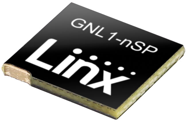
The ANT-GNL1-nSP is a surface-mount embedded GNSS antenna supporting GPS, Galileo, GLONASS, BeiDou and QZSS in the L1/E1/B1 bands. The ANT-GNL1-nSP antenna exhibits high performance in a compact size (10 mm x 8 mm x 1 mm) and features linear polarization and an omnidirectional radiation pattern. The antenna is available in tape and reel packaging and is designed for reflow-solder mounting directly to a printed circuit board for high-volume applications. Linx Technologies, linxtechnologies.com
Image: OriginGPS
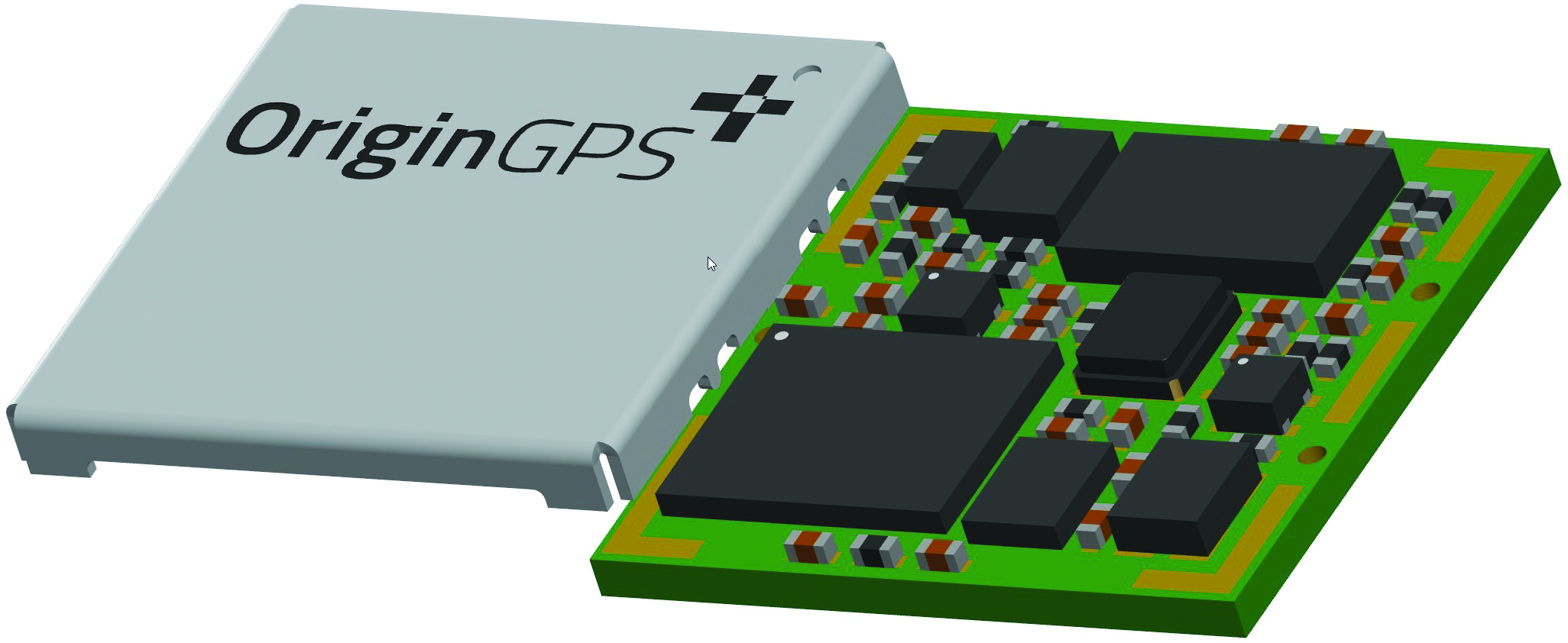
GNSS Module Based on a MediaTek chipset
The ORG4600-MK01 dual-frequency module provides higher precision than the company’s previous modules. It has sub-1 m precision at a cost lower than that of the company’s first L1+L5 module, the ORG4600-B01, which is based on Broadcom’s chipset. The 10 mm x 10 mm ORG4600-MK01 was designed for applications deployed in challenging environmental conditions. The solution also includes RTCM, a logger and accurate orbit prediction. OriginGPS, origingps.com
MAPPING
Image: Mapbox
Navigation Software Includes enhancements to existing software and more
Navigation software development kit version 2.9 provides pre-built applications compatible with Android and IOS. SDK v2.9 provides the primary navigation components across a workflow using lines of code instead of starting from square one. The drop-in user interface is customizable to reflect a developer’s brand, obviating the need to manually develop a full end-to-end application. Navigation SDK Copilot — a backend analytics tool for CX on navigation applications — collects trace files of navigation sessions and search analytics data from users. Developers can use this data to gather feedback and collective user data to create touch points with users and improve application experience based on their data-drawn conclusions. Matrix API has been updated to support scheduled departure times and provide optimal driving routes, creating a more accurate estimated time of arrival. Mapbox, mapbox.com
Image: Hexagon
Defense Platform For developing Android applications
LuciadCPillar is designed for the development of mobile applications for dismounted soldiers in the field. Developers can build applications with 2D and 3D views. It features military symbology and supports many geospatial data types including vector data, raster data, elevation data, point clouds and 3D meshes. It has the same capabilities found in desktops, in-vehicle and browser applications built with LuciadLightspeed, LuciadCPillar and LuciadRIA. The platform offers capabilities to match high-resolution screens, graphic processing units and multi-core processors including the ability to display 3D data in mobile applications. LuciadCPillar supports ARM processors and an application programming interface, which aligns with the Android developer experience. Impact, a French system integrator, partnered with Hexagon to test LuciadCPillar and will integrate it into its Delta Suite product, which is used by the French Special Operations Command. LuciadCPillar is part of Luciad 2022.1, which is available now globally. Hexagon, hexagon.com
Image: Golden Software
Surface Mapping Designed for 3D surface mapping
The Surfer package is designed for 3D surface mapping and provides robust subsurface visualization and modeling functionality by incorporating many true 3D gridding and visualization tools. With the enhanced functionality, users can now model an additional variable, a C variable, such as a contaminant or chemical concentration, along with the traditional X, Y, Z values. Surfer also includes the ability to create a 2D map of a slice-through 3D grid, which users can move up and down through the grid, illustrating how the C value changes with depth. Part of Surfer’s enhancements is isosurface creation, enabling visualization of the 3D grid in the 3D view as an isosurface, providing another way to see how C data varies with depth or elevation. The new 3D-rendered volume functionality also allows users to visualize the 3D grid in the 3D view as a solid body by assigning colors to different C values, highlighting variations in the data. Golden Software, goldensoftware.com
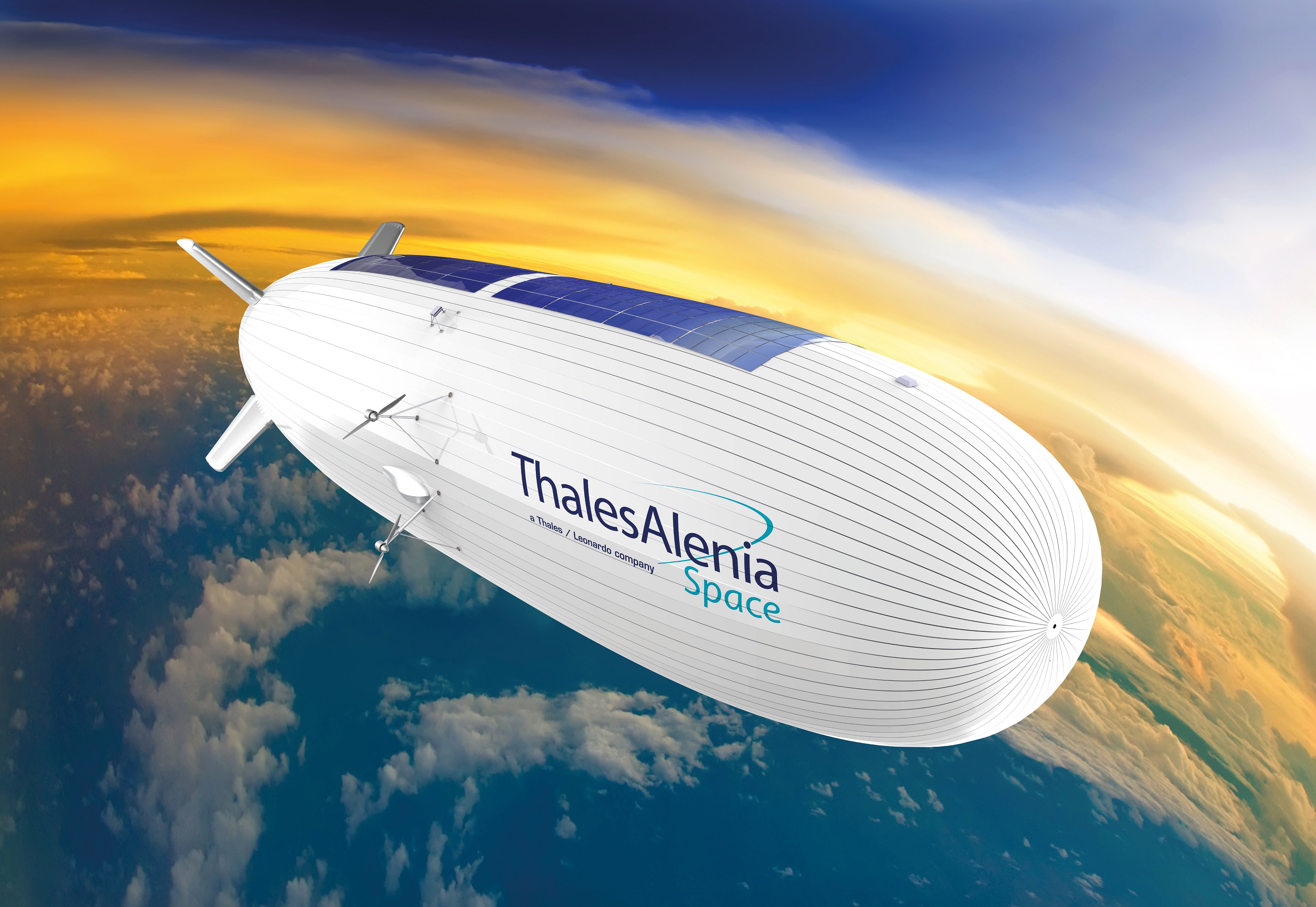
Thales Alenia Space has signed a €43 million contract for the Euro High-Altitude Platform Systems (HAPS) demonstration project. EuroHAPS was selected by the European Commission on July 20, 2022, for collaborative defense research and development projects from the European Defense Fund.
EuroHAPS aims to develop several stratospheric demonstrators for missions designed to improve intelligence, surveillance and reconnaissance and communications capabilities. Project partners include companies from Italy, Spain, Germany and France.
The project will conduct flight demonstrations for three types of complementary stratospheric platforms: A reduced-scale Stratobus from Thales Alenia Space, a solar-powered airship designed for long-endurance missions and offering large payload capacity, Hybrid High Altitude Airship from the Italian Aerospace Research Centre capable of generating extra lift with a wing airfoil, and autonomous stratospheric balloon system from ESG and TAO consisting of a series of three altitude-controllable balloons.
These three types of platforms are complementary and feature different operating times, capacity and operational restrictions. They will give Europe a broad spectrum of solutions to meet a variety of different requirements.
The platforms will test a range of missions, including lidar observation to detect and classify targets at sea or on land and the ability to detect them in environments with vegetation cover. Communications intelligence and electronic intelligence missions will also be tested, as well as a meshed broadband communications network for air and land players.
HAPS offer a new opportunity to complement ground-based, satellite-based or airborne assets with unique capabilities tailored to operational requirements. These flight demonstrations of HAPS will enable demonstrations of different platforms and address the main technical risks associated with these new technologies while refining operational requirements to ultimately enable development of future HAPS systems.
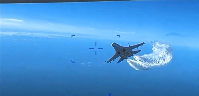
An MQ-9 Reaper UAV has collided with a Russian Su-27 fighter jet after it tried to spray the UAV with jet fuel, reports ABC News. The U.S. European Command has released a video that was taken from a camera the bottom of the UAV and shows the moment the collision occurred.
The Russian fighter jet took two passes at the UAV. During the second attempt to spray the UAV with jet fuel, they collided. Communication with the UAV was lost momentarily after the collision.
From the video, one of the propeller blades of the UAV seems to be damaged.
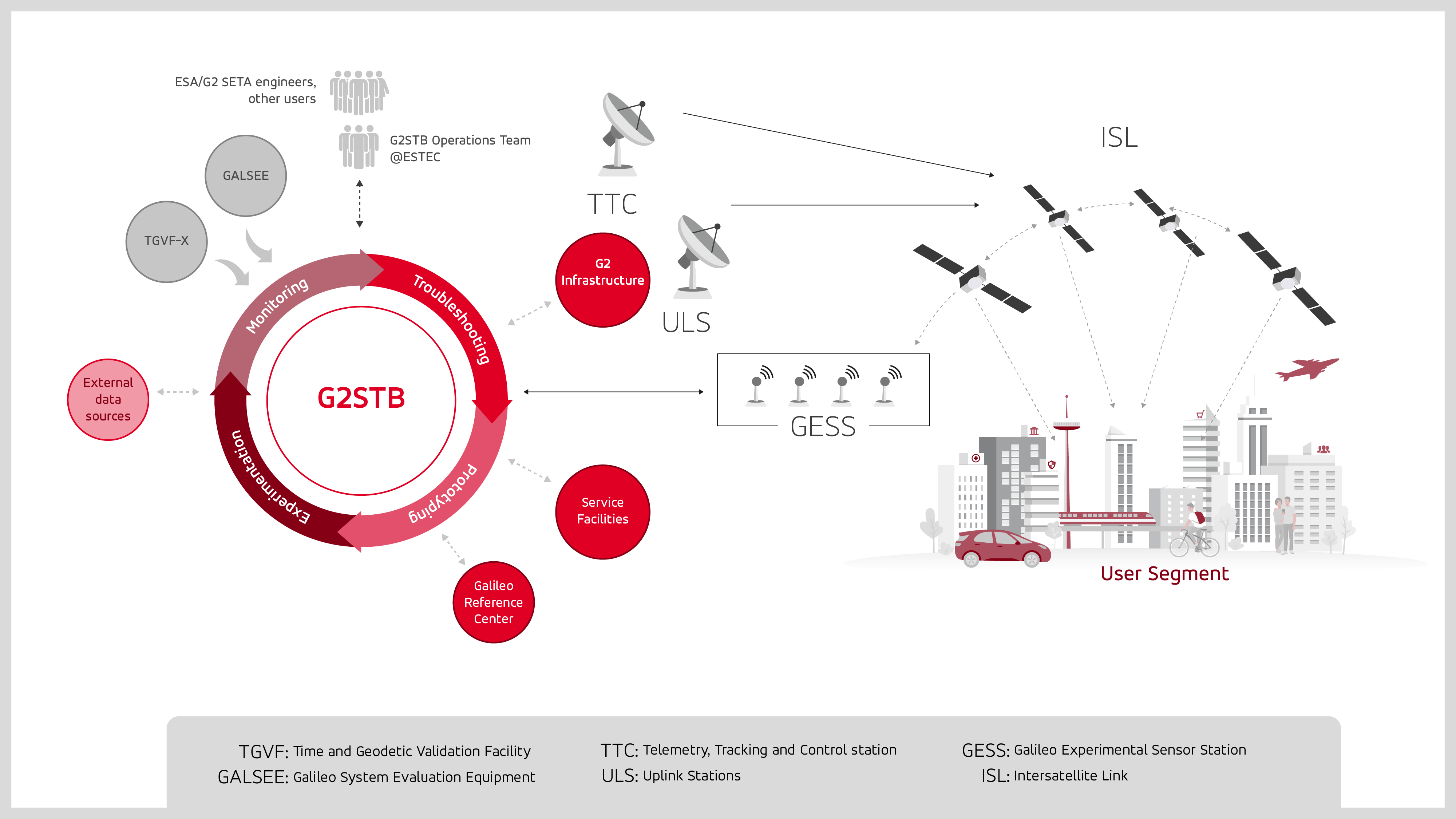
GMV has been selected by the European Space Agency (ESA) and the European Union Agency for the Space Programme (EUSPA) to develop the Galileo second-generation system test bed (G2STB). The G2STB will provide ESA with a key system verification and validation facility in support of its role as Galileo system development prime, enabling a wide range of Galileo system monitoring, troubleshooting, prototyping and experimentation activities.
GMV will deliver four G2STB versions over five years. Among these modules, the G2 high accuracy service (HAS) data generator and monitor aims to improve the Galileo HAS that was declared operational in January.
Other early capabilities of the G2STB include an upgraded orbit determination and time synchronization facility — capable of processing inter-satellite link data, a time service monitoring module, an integrity support message generator, a signal authentication service, an authentication validation module, an emergency warning service module, an ISL simulator and a G2G message composer.
The G2STB project aims for a smooth transition from the Galileo first-generation to the second-generation, building onto the G1G legacy system tools. The G2STB is one of the key infrastructure elements that ESA is developing for the correct functioning of the Galileo second-generation satellites.
The G2STB will eventually replace and upgrade the capabilities of the two first-generation facilities, the Galileo system evaluation equipment and the time and geodetic validation facility (TGVF-X). The latter, developed and operated by GMV over the last decade, has played a key role in monitoring the Galileo signals and system validation activities during the Galileo exploitation phase. The TGVF-X is also contributing to the early validation of new capabilities and elements being rolled out in recent and upcoming Galileo System updates.
In parallel to the development phase, the G2STB will help upgrade the network of Galileo experimental sensor stations to process new signals and capabilities to ensure the availability of a G2-capable, worldwide, multi-constellation network of receivers and bit-grabbers — independent from the operational Galileo sensor stations.
The Navigation Support Office at the Mission Control Centre of the European Space Operations Center (ESOC) has been tasked with providing independent precise orbit determination for European space missions. ESOC, which is based in Darmstadt, Germany, is a part of the of the European Space Agency (ESA). ESA aims to use high-quality signals from Galileo alongside GPS to sharpen the orbital positioning levels for future space missions.
The Navigation Support Office has used the positive results of the Copernicus Sentinel-6 mission — one of the first missions to fly a joint Galileo-GPS capable receiver, which improved positioning capabilities — to prove to ESA mission teams that future missions can harness the power of Galileo to improve positioning accuracy.
Missions in the works
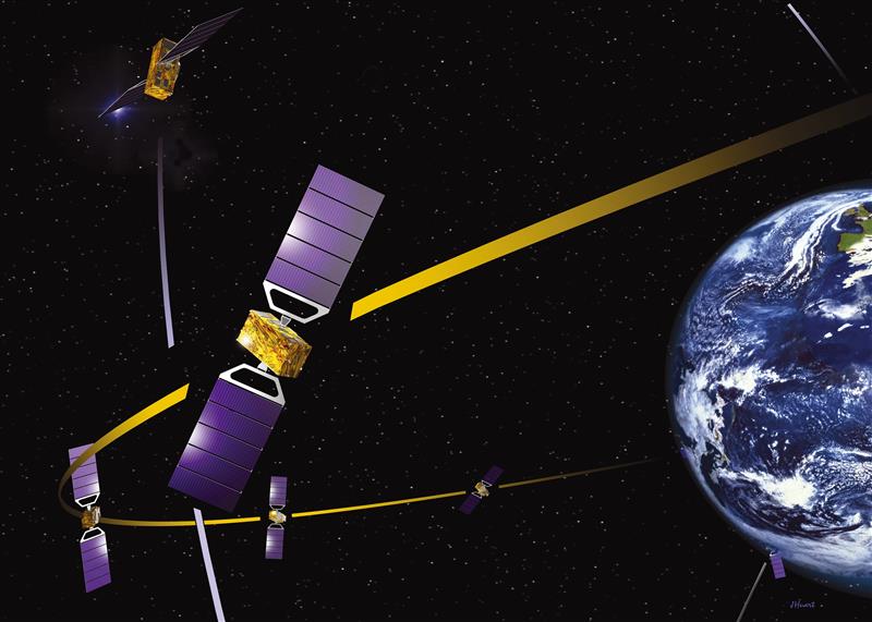
Proba-3 is a precision formation flying mission that aims to launch in 2024. The mission consists of two small satellites launched together that will separate to fly in tandem to prepare for future multi-satellite missions flying as one virtual structure. This mission will require millimeter-scale positioning precision and use a variety of positioning methods, including optical, radio and laser links and GNSS such as Galileo.
The ESA-supported Lunar Pathfinder will be launched into lunar orbit in 2024 with the intent of using it as a communication satellite for future moon missions. The spacecraft will incorporate a specially designed GPS- and Galileo-capable receiver that aims to demonstrate the feasibility of positioning fixes from 400,000 km away.
The future of Galileo
Galileo serves Europe and the world with accurate and reliable navigation services as well as a catalyst for future space missions — making it a critical aspect of both everyday life and the enhancement of accurate navigation. The constellation will continue to grow with 10 more Galileo first-generation satellites planned for launch in the next few years. Second-generation Galileo satellites with enhanced capabilities are being built for testing and qualification at ESA’s European Space Technology and Research Centre as well.
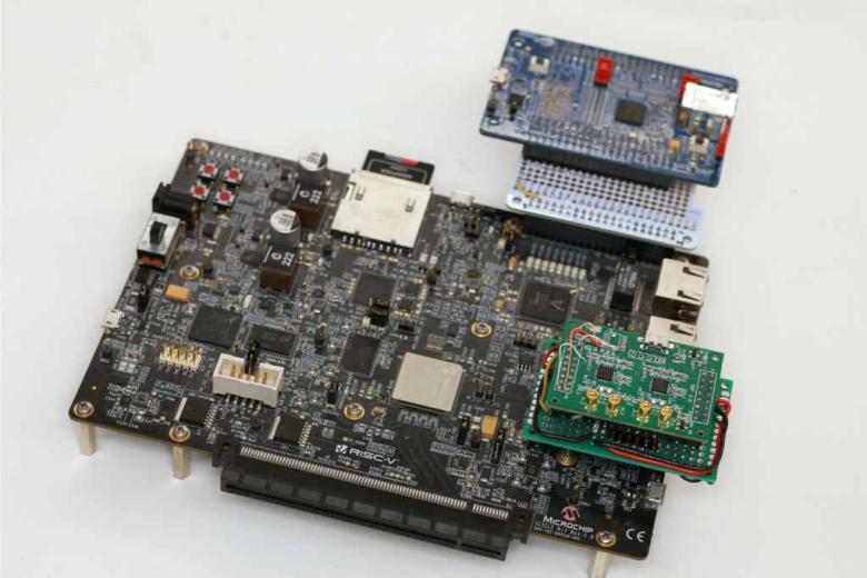
The University of New South Wales has developed an advanced GNSS receiver that can receive signals from GPS and Galileo satellites across multiple frequencies. The Australian Space Agency provided funding for the project via the International Space Investment initiative.
The receiver may play a key part in the future for Australian space missions.
Professor Andrew Dempster, director of the Australian Centre for Space Engineering Research (ACSER), led the development of the receiver and notes that it is an upgrade of Kea, a receiver made in Australia and New Zealand.
“The idea was to take that work (on Kea) and upgrade it for this multi-frequency, multi-system solution,” Professor Dempster said. “We needed to scale up the performance of many of the components on the boards – in particular, where the digital processors and hardware live.”
ACSER aims to have the receiver support upcoming satellite missions. The receiver can provide precise positioning, timing and velocity information. It enables satellites to produce higher quality images from space with better pointing.
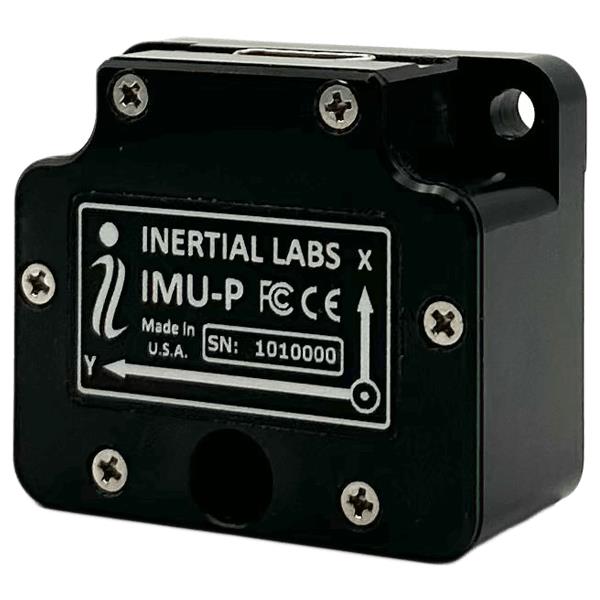
Inertial Labs has launched its inertial measurement unit-P (IMU-P). It is an advanced MEMS sensors-based, compact, self-contained strapdown, industrial- and tactical-grade inertial measurement system and digital tilt sensor that measures linear accelerations, angular rates and pitch-and-roll with three-axis, high-grade MEMS accelerometers and three-axis, tactical-grade MEMS gyroscopes.
Angular rates and accelerations are determined with high accuracy for both motionless and dynamic applications.
Like Inertial Labs IMU-FI-200C, the IMU-P is fully calibrated, temperature compensated, and mathematically aligned to an orthogonal coordinate system. IMU-P demonstrates less than 1 deg/hr gyroscopes and 0.005 mg accelerometers bias inrun stability with low noise and high reliability.
The IMU-P models collect data from an external source of GNSS to output full spectrum inertial navigation system data consisting of positions, attitude, velocity and time.
The IMU-P is suitable for applications such as antenna and line of sight stabilization systems, GPS-aided INS, UAV & AUV/ROV navigation and control and more.
NV5 Geospatial has forged a contract with the Caribbean Community Climate Change Center (CCCCC) to conduct aerial lidar and orthoimagery surveys across the Caribbean. The pilot project will provide advanced geospatial data to help the island nations understand natural and man-induced climate changes, develop programs to support resilience and sustainable development, and establish a foundation for future work.
NV5 Geospatial will conduct topographic and topobathymetric lidar surveys, as well as orthoimagery, via a fixed-wing aircraft. Data collected will help CCCCC address the impact of climate variability and identify potentially hazardous impacts.
The project will cover 10 sites spread across more than 3,000 km. The sites include areas in Suriname, Guyana, Tobago, Barbados, St. Vincent and the Grenadines, Saint Lucia, Antigua and Barbuda, St. Kitts and Nevis, Turks & Caicos and Belize.
Other logistical considerations include the combination of microclimates inherent around tropical islands, highly variable weather conditions, cloud formations and jungles, some of which are in high relief areas or covering the entire area.
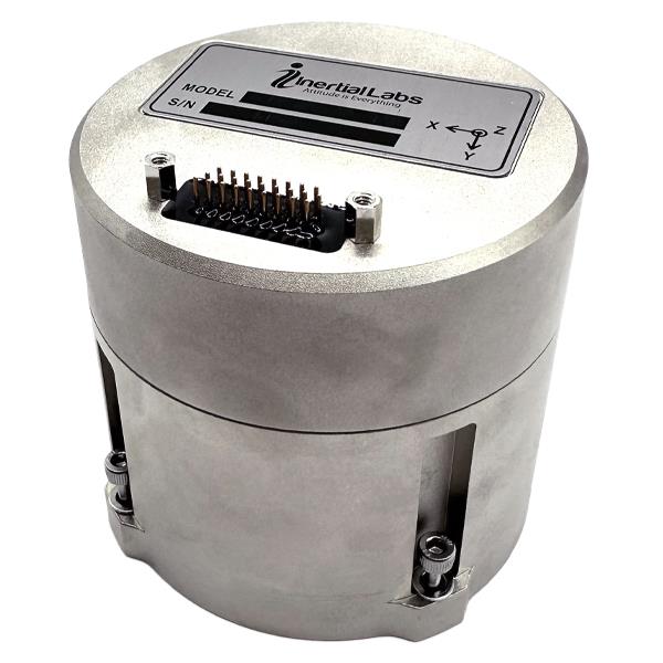
Inertial Labs has released its IMU-FI-200C, a compact, self-contained strapdown, advanced tactical-grade inertial measurement unit (IMU) device. The IMU-FI-200C measures linear accelerations and angular rates with its three-axis, tactical-grade, closed loop, fiber-optic gyroscopes and three-axis, high-precision MEMS accelerometers in motionless and high dynamic applications.
The IMU-FI-200C is fully calibrated, temperature compensated and aligned to an orthogonal coordinate system. It contains more than 0.5 deg/hr gyroscopes and less than 2 mg bias repeatability over operational range accelerometers with low noise and high reliability.
Continuous built-in test, configurable communications protocols, electromagnetic interference protection, and flexible input power requirements make the IMU-FI-200C suitable for a wide range of integrated system applications.
AUVSI has launched Green UAS, a program to expand the amount of commercial UAS that have been verified to meet high levels of cybersecurity and National Defense Authorization Act supply chain requirements.
Green UAS meets the Blue UAS certification program of the Defense Innovation Unit. It is designed for users who do not immediately require Department of Defense authority to operate.
Green UAS also offers a streamlined pathway to the Blue UAS 2.0 cleared list.
Green UAS is suitable for users who rely on commercial, off-the-shelf UAVs to conduct diverse operations. These users include federal government agencies, local law enforcement, first responders and state departments of transportation.
Green UAS is also suitable for industrial enterprise users such as energy and utility companies, telecoms, manufacturers, food and agriculture, and logistics and mapping/surveying companies.