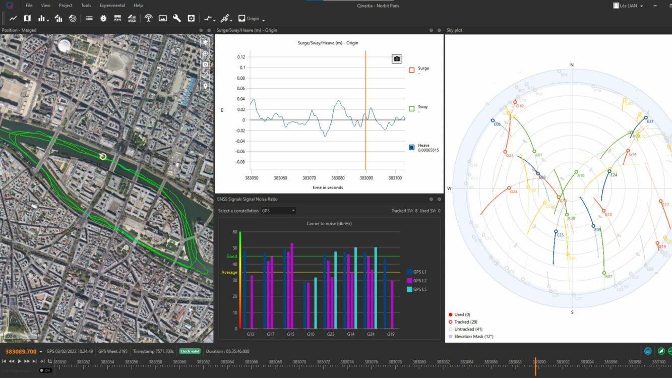
SBG Systems will release the newest version of its Qintertia technology, Qinertia 4, on November 7, 2023. This version introduces several innovative features that provide users with a complete solution for precise trajectory and motion analysis.
Qinertia is a post-processing software delivering better precision and reliability compared to RTK systems. Qinertia 4 has an enhanced Geodesy engine to boasts an extensive selection of preconfigured coordinate reference systems (CRS) and transformations, making it a versatile solution in applications that use diverse geodetic data, including land surveying, hydrography, airborne surveys, construction and more.
To tackle the challenges of variable ionospheric activity, the new technology uses Ionoshield PPK mode. This feature compensates for ionospheric conditions and baseline distances, allowing users to perform post-processing kinematics (PPK) even for long baselines or harsh ionospheric conditions.
Another addition to Qinertia 4 is extended continuously operating reference stations (CORS) network support. This feature offers users a vast network of 5000 SmartNet for reliable GNSS data processing.
Qinertia has more than 10,000 bases in 164 countries. This global coverage ensures that Qinertia remains a reliable and efficient solution, regardless of geographic location. In addition, users can import their own base station data and verify its position integrity with precise point positioning (PPP).
For data that cannot be processed using PPK, Qinertia 4 offers an alternative solution with its new tightly coupled PPP algorithm. This new processing mode, available for all users with active Qinertia maintenance, provides post-processing anywhere in the world without a base station, with a horizontal accuracy of 4cm and a vertical accuracy of 8cm.
Qinertia’s new functionalities will be demonstrated live at Intergeo 2023 in Berlin.
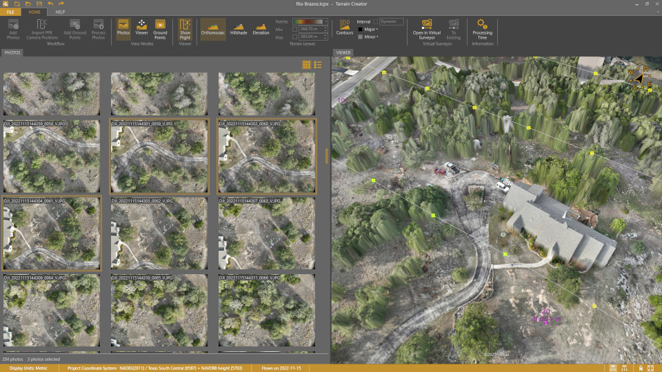
Virtual Surveyor has added UAV photogrammetry capabilities to its Virtual Surveyor smart UAV surveying software. The new Terrain Creator app photogrammetrically processes UAV images to generate survey-grade terrains which then transfer into the traditional Virtual Surveyor workspace.
The Virtual Surveyor software is now two desk apps in one subscription package, creating a seamless end-to-end UAV survey workflow, said Tom Op‘t Eyndt, Virtual Surveyor’s CEO.
Terrain Creator aims to simplify the aerial photogrammetry process by offering a visual and intuitive application to produce an orthomosaic and digital surface model (DSM) from UAV photos, the company said.
Virtual Surveyor software was originally developed to bridge the gap between UAV photogrammetric processing applications and engineering design packages.
Prior to this new release, users had to rely on third-party software to generate elevation models and an orthomosaic on which they could work with the Virtual Surveyor toolset. Now, users can derive the 3D topographic information necessary for construction, surface mining and excavation projects in one package.
Once the survey-grade terrains flow from the Terrain Creator into the Virtual Surveyor desktop app, users can access an interactive virtual environment and robust toolsets to generate CAD models, create cut-and-fill maps and calculations, or calculate volume reports.
Users currently subscribed to Virtual Surveyor Ridge and Peak editions will see their software updated automatically with Terrain Creator. A flexible licensing setup will allow two users within a subscribing organization to use the Terrain Creator and Virtual Surveyor applications simultaneously from different computers.
The phrase “positioning, navigation, and timing” (PNT) — widely used in our industry, including on this magazine’s cover — encapsulates a wide range of applications for global navigation satellite systems (GNSS) and for other technologies that provide some or all the same services. Subsumed under “positioning” is one of the most widespread uses of GNSS, which is data collection to make maps, enable geographic information systems (GIS), and populate the databases that power the many location-based services (LBS) applications on smartphones.
Increasingly, GNSS positioning is also integrated with systems for indoor positioning to enable seamless tracking of people, equipment and products, and with a variety of sensors to monitor their status and environmental conditions.
GNSS positioning and mapping will benefit from the advent of G5 cellular networks, which will vastly increase download speeds, decrease latencies and expand connectivity. While it will transform every industry, 5G’s impact will be especially felt in urban settings and pave the way for tomorrow’s smart cities.
In this month’s cover story, we focus on these aspects of GNSS by presenting three brief case studies:
Golf course irrigation planning and construction, using Trimble Catalyst.
Land surveys to update China’s national GIS, using a CHC Navigation LT700 receiver.
Safety with industrial automation
Industrial automation is an extremely wide area,” said Ludger Boeggering, u-blox senior principal segment manager, EMEA Energy & Automation. “It includes process and production automation, where it is used to automate the production environment. In more remote conditions, where it is less time-critical, it is used to understand what happens in the automation environment. Lastly, it is used to remotely supervise and monitor what is happening in such an environment.”
Nowadays, businesses want to monitor their production environment “all the way down to the production of a single device,” Boeggering said. “That’s the area in which we operate.”
One application of industrial automation on which u-blox is increasingly focusing is the safe, connected worker, which can refer to someone inside a building on a factory floor or someone outside, such as on a construction site. Another one is mobile robotics and collaborative robotics.
“Our customers are in all segments and verticals — including electronics, machine manufacturing, oil and gas, transportation, chemical, food, water, paper and energy,” Boeggering said. “It’s really a broad spectrum of industrial companies that are using these tools and products. We are focused on the leading customers in that area and are working with well-known players in the market.”
5G is an umbrella for different flavors of the technology that includes enhanced mobile broadband and ultra-low latency. “There has been much hype about this,” Boeggering said. “In the beginning, everyone focused on low latency and, potentially, high bandwidth. In reality however, customers realized that it would be too expensive to implement it so as to have both.” This led to the emergence of 5G RedCap, which stands for reduced capability. “It covers a bit of the low latency stuff and a bit of the higher bandwidth stuff, but also makes it more cost effective.”
For many applications, such as video and augmented reality, latency is less important than speed. Then there’s the question of reliability. “Nowadays, reliability and availability are the most important issues,” Boeggering said. “If you have an automation process with very high motion, you definitely need high reliability and low latency.”
Factories can now set up their own environment and combine communication technologies, using low latency and many sensors. “For example, on the campus of a chemical factory you have some critical processes that require reliable connectivity,” Boeggering explained. “There, 5G can provide that. At the same time, there are hundreds of thousands of sensors to be connected. This requires a private network environment that can be controlled.”
“The reason for going wireless is less about being mobile and more about being flexible — such as setting up or re-arranging a production line in a very short time,” Boeggering said. “It normally takes a car manufacturer nine to 12 months to set up a production line for a car. It requires a lot of cables and installations. These guys aim to bring that time down to three months. That means that when they are starting to rebuild a construction area, in the best case, they can make the connectivity for all the communications entirely wireless and just plug the machines into the power.”
Construction sites require a solution that provides a seamless indoor-outdoor location. For example, a construction company may want to know the location of all its tools on a large campus. When they are outside, they can be easily located with GNSS. More often, however, they are inside concrete walls. “Nowadays, we don’t really have a solution that covers that indoor-outdoor area seamlessly,” Boeggering said. “On a construction site, you can’t set up an infrastructure to do that. So, you need one that is already available. There 5G might be able to help.”
u-blox can provide solutions that fit across the communication technologies. “5G is not the only technology that will be used in industrial automation environments,” Boeggering pointed out. “We have the portfolio, starting with GNSS when it comes to location, and, when it comes to short range, wireless, Bluetooth, Wi-Fi, and of course, cellular. We are providing to these OEMs the right components to create the final solution, including positioning and communication services.”
“The customers, who want to know where their equipment is, do not care whether that information is derived using GNSS, Bluetooth, or Wi-Fi,” Boeggering said. “They just want to know in which room it is, on which level, or in which area of their factory. Of course, customers certainly would like centimeter precision. However, the question is whether they want to pay for it. GNSS plays a huge role for location outside and close to windows. However, once you can’t get this data, you need an alternative solution. This can be done in combination with any wireless technology. There are use cases in which Bluetooth might work independently from GNSS, but when it comes to Wi-Fi or cellular 5G, GNSS is definitely helping to get the location. So, we always play a role.”
Irrigating the green
“We’ve always used GPS equipment to map out our clients’ properties across the country,” said Michael Kuhn, owner of Michael Kuhn & Associates Inc., in Birmingham, Michigan, which specializes in irrigation systems for golf courses. “Very rarely do they have an accurate base map of the property. So, instead of going to third parties, we decided 20 years ago to buy our own GPS equipment and map these properties ourselves as a starting point to do our design work for new irrigation systems,” Kuhn said.
The Trimble Catalyst. (Image: Trimble)
Since starting his business, Kuhn is now on his third or fourth generation of Trimble equipment. “Convenience and time are always key factors with me,” he said. “As this equipment has evolved, it’s become more user friendly, and more convenient.”
He spends a lot of time on the road and needed a way to collect data on golf courses and get it to his staff back at the office, so that they could clean it up and get it ready for him as quickly as possible. Before Trimble released Catalyst, he had to go back to his hotel, remote into his office computer and transfer the data from his laptop through some kind of cloud-based device. “Now, with this new Catalyst equipment, it is so much more streamlined, and the price point has been fantastic,” Kuhn said. “Everything’s now going subscription-based anyway. Not just software but hardware as well. That allows me to do a few more things that I couldn’t do before.”
The golf courses around the country with which Kuhn works are constantly doing projects and updating infrastructure. “We end up being the gatekeepers for the overall mapping for our clients’ golf courses for infrastructure,” he said.
Before Trimble released Catalyst, Kuhn recalled, some of his clients spent up to $30,000 for equipment that would collect data sufficiently accurate to incorporate into his mapping.
“When Trimble came out with Catalyst and a subscription-based pricing, depending on what kind of accuracy you need, it was a no brainer. The first group that I thought of was my clients — giving them the ability to get entry-level subscriptions, but still be able to maintain centimeter-grade accuracy because they’re using an hourly subscription instead of paying thousands of dollars a year.”
Kuhn also uses aerial photogrammetry.
“Not that long ago, it was tough to get your hands on ortho-corrected aerial photography that could match up with my base maps,” he recalled. “I would typically go to municipalities. More and more of them have GIS departments now. Often, I could get access to ortho-corrected aerial photography from them, either for free or at a cost. It was accurate, but you would be at the mercy of whenever the county was doing its aerial photography,” Kuhn continued.
Then Kuhn came across Nearmap and began to use their aerial photography. “It wasn’t ortho-rectified at all, but they were flying multiple times a year,” Kuhn said. “It was nice to incorporate it into what we were doing, to make sure that I could see the latest and greatest overhead of whatever property I was looking at.” When Nearmap switched to a subscription-based business model, however, Kuhn did not sign up because the images were not georeferenced. “It’s a lot of work when you must manipulate an aerial and get it to match up to a base map. Then, probably two or three years ago, they started to geo-reference their aerial imagery and we signed up and they’ve been great.”
Right now, Kuhn’s equipment is close to centimeter-grade. “We were the first independent irrigation consulting partners to get this three-dimensional hydraulic modeling software to run our irrigation systems,” he said. “In a three-dimensional model, before we even finalized drawing, we were able to model the systems that we were designing that could tell us what pressure drops were across a 500-acre piece of property three dimensionally.” That required a topo map of the property, which he would get from the relevant county.
Pump stations for golf course irrigation systems pump 2,000 or 3,000 gallons a minute across hundreds of acres, sometimes in the mountains and typically full of steep inclines.
Image: Michael Kuhn & Associates Inc.
“It could be in Colorado or Salt Lake City or in a place flat as a pancake, but it is absolutely critical to still have the ability to run that hydraulic model and have accurate data flow horizontally and vertically,” Kuhn said. “With the data that we have now, I can run an irrigation cycle in multiple different ways and tell the end user what the pressure is in the back left corner of a green within 1/100 psi. It’s invaluable.”
Kuhn supports his clients in many ways. “Since the Trimble Catalyst equipment came out, I’ve recommended to my clients and to contractors that they switch to it. Golf course building contractors have always had good equipment, such as total stations, and this was just another tool that they could have to collect data quickly and easily.”
Additionally, Kuhn pointed out, Catalyst provides a sharing platform. “So, I could create a team for a golf course and then they could get the same equipment and create a project and we can make each other part of each other’s team. So, they have access to all the data that they collect and all the data that I collect, to the extent that I give them permission to use them. That’s critical. I mean, sharing data with contractors is another component that we really didn’t have before.”
Collecting data for GIS
Image: CHC Navigation
CHC Navigation is assisting China’s Ministry of Natural Resources to conduct its third national land survey. The ministry regularly organizes nationwide land surveys to update the country’s national GIS database, including spatial and attribute information. In addition, surveyors are required to take multiple high-resolution images of each area in different directions to provide verification information. As the project progresses, all data will be uploaded to a server via a cellular (4G) connection. In terms of accuracy, this project requires an expected accuracy in the order of one meter.
For this project, China’s Ministry of Natural Resources used the CHCNAV LT700 rugged Android tablet. Featuring an 8-in screen viewable in direct sunshine and in high-bright areas, the LT700 is well suited to display GIS data tables, complex vector and raster maps or high-resolution pictures. Unlike consumer tablets, the L700’s IP67 industrial design withstands daily use in harsh environments and conditions. Protected from dust, rain, extreme temperatures and accidental drops from 1.2 m, the LT700 is an advanced solution for such applications as forestry, utilities, asset management or environmental studies. Bearing the Google Mobile Service (GMS) certification, the LT700 runs seamlessly the most common professional data collection applications available from the Google Play store.
The main challenges associated with using data collectors in the field are related to the natural environment and the need to ensure reliable georeferencing accuracy down to the meter. Surveyors and GIS technicians work in a variety of environments, including cities, mountains, plateaus and forests. They can work for up to eight hours in rain, snow and extreme temperatures. As a result, their equipment must be well protected from shocks and bad weather, with long battery life and a high-brightness display.
A GIS specialist collecting the locations of assets using an LT700H RTK Android tablet by CHC Navigation, which has centimeter accuracy. (Image: CHC Navigation)
With the LT700 rugged tablet, surveyors can focus on collecting data in the field without interruptions or wasted time, and without worrying about weather conditions. The device delivers metric accuracy with SBAS support, which greatly improves the reliability of georeferencing and the consistency of collected data, regardless of the operator. Its lightweight construction and convenient size make it easy to transport on foot, especially when working in mountainous terrain or crossing rivers. The LT700’s 4G connectivity has made it possible to continuously update data and organize work sessions based on updated data.
Back in the late 1980s, as project manager of the new adjustment of the North American Vertical Datum of 1988 (NAVD88), I worked with federal and state agencies to perform geodetic leveling and replace lost benchmarks. One of the reasons for the NAVD 88 project was to address the issue that thousands of benchmarks placed in previous decades had been subsequently destroyed and many others had been affected by crustal motion, postglacial rebound, and subsidence due to the withdrawal of underground fluids. NGS along with its partners performed thousands of kilometers of leveling to replace lost benchmarks. That said, the loss of control marks, denoted by some as “passive marks,” still seems to be a problem today.
California surveying agencies played a part in replacing and updating lost marks for the NAVD 88 project and it seems that they are doing it again. On Sept. 21, the importance of saving passive marks was discussed at the 2023 CLSA Geomatics Conference at Cal Poly Pomona/College of Engineering.
Defining passive marks
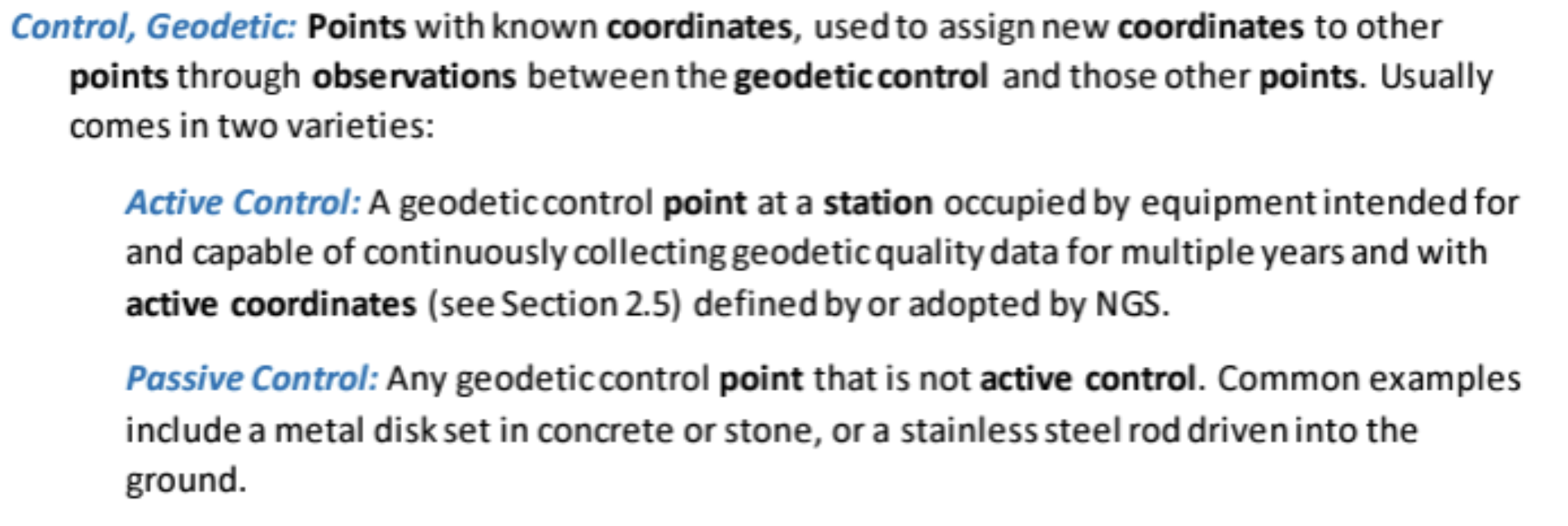
Several of my previous columns have highlighted the new, modernized NGS National Spatial Reference System (NSRS), and how active and passive control will be part of the new system.
Active and passive control. (Image: NGS)
For all practical purposes, passive marks are marks that are not continuously operating reference stations (CORS).
On June 22, NGS held a webinar on the benefits and challenges of transitioning to the modernized NSRS at which the presenters were not NGS employees. Users can download the presentation here.
NGS webinar on June 22. (Image: NGS)
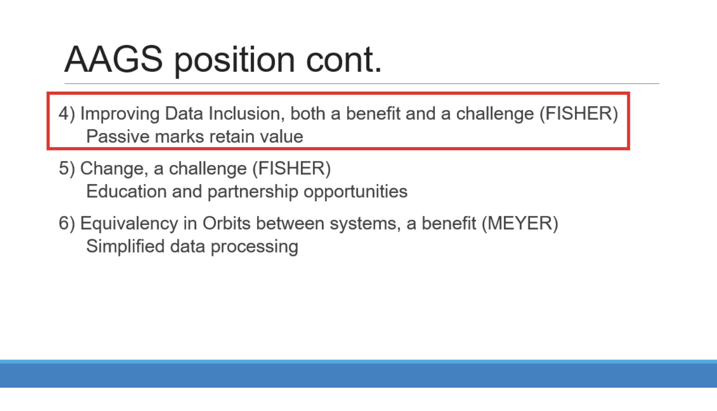
I want to highlight a few statements made by Brian Fisher, director of the American Association for Geodetic Surveying (AAGS). Readers can find more information about AAGS here. First, one of Brian’s slides stated that passive marks retain value and that improving data inclusion is both a benefit and a challenge. During his presentation, Brian stated that “passive marks are always going to have some level of value.” He also mentioned that “NGS has done a great job on improving the data submitting process.” NGS is developing models and tools for users to transition to the new NSRS. Tools such as OPUS Projects aim to help facilitate incorporating passive marks into the new, modernized NSRS.
(Image: NGS)
Brian is not the only one who knows the importance of passive marks. As previously mentioned, the importance of saving surveying control marks was highlighted at the 2023 CLSA Geomatics Conference at Cal Poly Pomona/College of Engineering.
2023 CLSA Geomatics Conference. (Image: Cal Poly Pomona)
At the conference there was a panel session on saving survey monuments.
The following is the abstract of the panel session:
“To discuss an ongoing problem of the destruction of land survey monuments and what the League of California Surveying Organizations (LCSO) and the California Land Surveyor’s Association aredoing about it.”
The panel consisted of five California County surveyors including David Farrell (LA Deputy County surveyor), Tom Herrin (San Bernardino County surveyor), Michael Lafontaine (Orange Deputy County surveyor), David McMillan (Riverside County surveyor), and Warren Smith (Tuolumne County surveyor). The presentation included discussion of a Monument Preservation Brochure and a Monument Preservation Guide.
Surveyors, engineers, and GIS professionals realize that inaccurate measurements can lead to boundary disputes, errors in construction projects, and environmental impacts. Passive marks are useful for validating measurements and spatial analysis. The panel noted that marks across California are in danger of being damaged or destroyed due to construction or insufficient public awareness. It was noted that addressing the loss of passive marks is important for maintaining California’s geographic information systems and preventing/averting legal disputes.
A goal of the guide is to provide individuals that oversee engineering work with strategies to save passive marks that are important to land boundaries and geospatial data.
The panel realized that survey monument preservation requires a collaborative effort from various stakeholders. By incorporating outreach, accurate locating techniques, efficient reporting systems and meticulous replacement strategies, California can safeguard its survey monuments for current and future generations.
The proposed guide will address the problem and outline a solution. The problem section would include topics such as lack of awareness, inadequate reporting, lack of funding, and the responsibility of the community. I have been informed that the guide will be posted here soon.
The panel members understood that the solution starts with outreach efforts and their draft guide lists the following potential outreach activities:
Educational campaigns at local schools, community centers, and public events to introduce the importance of survey monuments and their role in land ownership, land surveying and mapping.
Community workshops with local civic organizations, homeowners’ associations (HOAs), and chambers of commerce to conduct workshops focused on survey monument preservation.
Public awareness materials such asinformational brochures, posters, and online resources that explain the significance of survey monuments and the potential consequences of their damage or loss can be distributed through public libraries, city halls, and online platforms.
Media engagement with local media outlets can elevate public awareness and reinforce the importance of preserving these markers.
As part of the public awareness material the group has prepared a draft brochure. They mentioned that having a website, such as the CLSA website, be a hub for contacts and information for research may help support the “save the mark” campaign. They included that GIS web maps will be a common place to find monuments and survey control.
The draft brochure states, “destruction of survey monuments within the public rights-of-way, mainly as the result of public works projects and private developments permitted by public agencies, is increasing, due to a lack of oversight and education concerning the importance of these monuments.”
The draft brochure addresses the following questions:
What Are Survey Monuments, Bench Marks & Geodetic Control?
Why Are They Important?
What Can You Do to Preserve Survey Monuments?
Who Is Responsible?
How Many Survey Monuments Are Really Needed?
The use of passive marks is well known to land surveyors since they use these marks in their daily operations as described in the statement above. It is crucial to be informed of the importance of passive marks and what they can do to help preserve them. Any professional involved in urban development can have a role in saving passive marks from destruction.
The draft brochure outlines the following actionable steps that others can take: show all existing land survey monuments on improvement plans, grading plans, site plans, etc.; educate engineers, surveyors, plan checkers, inspectors, GIS professionals, and the public about the importance of monuments and the requirements to preserve them; prior to filing notice of completion for any project, have a licensed land surveyor validate that the monuments are in place; and request acknowledgement via a written statement in the permit process, that a licensed land surveyor has performed a field inspection and that no monuments are subject to destruction within the scope of the project, or that existing monuments have been referenced and perpetuated per Business and Professions Code §8771.
The section “How Many Survey Monuments Are Really Needed?” is kept simple and straightforward: all of them! These monuments are set to allow for the retracement (or to mark the location) of features and legal rights on Earth’s surface.
There are many scientists who believe that active control stations are the solution to the surveying and mapping community’s positioning requirements.
I believe active control stations such as NOAA CORS Network (NCN) that NGS promulgates are extremely important to the development and implementation of the NSRS. In the new, modernized NSRS access to the geometric component of the NSRS will effectively be defined by CORS and their coordinate functions. That said, this does not diminish the importance and requirement for maintaining and updating the coordinates of passive marks.
The brochure is still a draft document and was not ready for publication at the time of this newsletter, but I have been told that it will be sent to all California county surveyors with instructions on what the goal is. Also, I have been informed that, as soon as it is publicly available, it will be placed on the websites of the California Land Surveyors Association and The League of California Surveying Organizations.
I am encouraged by what California surveyors are doing to highlight the importance of passive marks. I would be interested in hearing from others on what they are doing to save passive marks or their thoughts on the importance of passive marks. Please feel free to email me at [email protected].
On a different topic, I would like to highlight that the NGS has announced the recipients of the NOAA FY 23 Geospatial Modeling Competition Awards. NGS awarded $4 million in grant funding to four institutions — Oregon State University, Scripps Institute of Oceanography, Michigan State University, and the Ohio State University — for projects that will research emerging problems in the field of geodesy, develop tools and models to advance the modernization of the NSRS, and help address a nationwide deficiency of geodesists.
This is great news for the advancement of geodesy. I will address this in more detail in my November column.
Emlid has launched a GNSS receiver, the Reach RS3. It features inertial measurement unit (IMU) tilt compensation and a dual-band radio for enhanced compatibility with third-party receivers.
The Reach RS3 enables users to survey at large tilt angles while maintaining survey-grade accuracy. The multi-band receiver works both as a base and a rover and comes factory calibrated.
The receiver offers versatile options to get corrections from continuously operating reference stations (CORS), another Reach device, or a third-party base, so users can mix and match real-time-kinematic (RTK) receivers in a fleet.
Its NTRIP connectivity enables corrections from CORS, NTRIP service, or a GNSS receiver using Emlid NTRIP Caster. When connected over NTRIP, Reach works on a baseline of more than 60 km in RTK and 100 km in post-processed kinematic. Emlid has launched a GNSS receiver, the Reach RS3. It features inertial measurement unit (IMU) tilt compensation and a dual-band radio for enhanced compatibility with third-party receivers.
The Reach RS3 enables users to survey at large tilt angles while maintaining survey-grade accuracy. The multi-band receiver works both as a base and a rover and comes factory calibrated.
The receiver offers versatile options to get corrections from continuously operating reference stations (CORS), another Reach device, or a third-party base, so users can mix and match real-time-kinematic (RTK) receivers in a fleet.
Its NTRIP connectivity enables corrections from CORS, NTRIP service, or a GNSS receiver using Emlid NTRIP Caster. When connected over NTRIP, Reach works on a baseline of more than 60 km in RTK and 100 km in post-processed kinematic.
“Seen & Heard” is a monthly feature of GPS World magazine, traveling the world to capture interesting and unusual news stories involving the GNSS/PNT industry.
UK begins UAV deliveries
Image: Screenshot of video by BBC
Royal Mail and UAV company Skyports have launched the Orkney I-Port operation to distribute letters and packages between the Orkney Islands, Scotland, reported the BBC. In partnership with the council’s harbor authority and Scottish airline Loganair, mail will be transported from Royal Mail’s Kirkwall delivery office to the city of Stromness in Orkney. UAVs will then carry items to the islands of Graemsay and Hoy, where postal staff will complete the delivery routes. The UAV service will initially operate for three months and may continue on a permanent basis under existing regulatory frameworks due to Orkney’s unique landscape and the proximity of the islands to one another. The UAV service aims to improve service levels and delivery times to Graemsay and Hoy, as weather and geography typically cause disruption to delivery services. The use of UAVs to deliver mail also may bring significant safety improvements by ensuring that postal workers can deliver between ports without risk.
GNSS is taking a hike, literally
Image: Aleksandar Georgiev/iStock/Getty Images Plus/Getty Images
In July, officials in Taichung City, Taiwan, launched a GNSS-based app to aid lost hikers and to mitigate risk associated with outdoor activities in the area’s mountainous region, reported Tapei Times. The app was developed by the Taichung Fire Bureau in response to a surge in outdoor activities after the COVID-19 pandemic restrictions were lifted and, subsequently, an increase in medical emergencies linked to mountain activities. Wi-Fi towers have been built at major trailheads such as Toukeshan, Anmashan, Fushoushan and Snow Mountain to supplement the app as well as to help facilitate UAV deployment to find lost hikers.
In a biological preserve in Mexico’s Campeche state, a team of archaeologists have documented pyramids, palaces, a ball court and other remains of an ancient city they call Ocomtún, reported The New York Times. Archeologists surveyed the site for six weeks in May and June, finding 50-foot-tall structures resembling pyramids, as well as pottery and Mayan engravings they believe date to between 600 AD and 900 AD. The team determined the city was likely abandoned more than 1,000 years ago. Surveying of the area has been revolutionized over the past decade by lidar — allowing researchers to survey densely forested areas that are difficult to explore on foot. Archeologists were able to use airborne lasers to pierce through dense vegetation and reveal the ancient structures and human-modified landscapes beneath.
More than 350 UAVs were lost during a practice light display show in Melbourne, Australia, on July 14, ahead of a scheduled performance for the opening of the women’s World Cup. The UAVs appeared to stop mid-show and plummet into the Yarra River. Divers have since fished out hundreds of the UAVs. According to the Resilient Navigation and Timing Foundation, the likely cause of the mass-crash was interference with GPS signals.
Rohde & Schwarz has partnered with Skylo Technologies, a global software-defined non-terrestrial network (NTN) operator, to set up a device acceptance scheme for Skylo’s NTN.
The proven device test framework from Rohde & Schwarz will be used to test NTN chipsets, modules and devices to validate their compatibility with the Skylo test specification.
The collaboration aims to reinforce and expand the testing capabilities for NTN, ensuring that chipsets, modules and devices using the NTN Narrowband Internet of Things (NB-IoT) protocol integrate seamlessly with Skylo’s network and are 3GPP Release 17 compliant.
The Rohde & Schwarz test framework is built on the R&S CMW500 wideband radio communication tester. The framework serves as the preferred choice for IoT testing, including research and development to GCF/PTCRB certification and carrier acceptance tests, covering both terrestrial and non-terrestrial IoT domains.
With the R&S CMW500 software stacks, the new framework offers reliable and repeatable results. It comes with NTN Release 17 features as well as support for different orbits.
The Department of Homeland Security (DHS) Science and Technology Directorate (S&T) has announced plans for a new testing program to evaluate how well GPS systems perform against spoofing and disruption exploits.
DHS S&T’s 2024 GPS Testing for Critical Infrastructure (GET-CI) event is scheduled for Fall 2024. It will allow critical infrastructure owners and operators (CI O&O) and GPS equipment manufacturers to identify any weaknesses in their equipment.
“Accurate and precise positioning, navigation and timing (PNT) information is vital to the nation’s critical infrastructure,” said Dimitri Kusnezov, DHS under secretary for science and technology. “The GET-CI test series are part of the S&T PNT Program’s collaborative efforts designed to help industry partners test and evaluate their technologies to become more resilient against PNT disruptions.”
Typical commercial testing and data collection occurs in a closed environment. This DHS S&T test will provide an “opportunity for CI O&O and manufacturers of commercial GPS receivers used in critical infrastructure to perform equipment evaluations in a rarely available live-sky spoofing and jamming environment,” said DHS.
The testing event also aims to create a live-sky GPS environment primarily for fixed infrastructure applications but will also support some ground-based mobile applications, according to DHS.
DHS is calling on commercial, academic and civil society organizations to submit applications by October 20, 2023, to participate in the testing event next year.
For submission instructions and further information, see the Request for Information for Participation (RFIP) announcement on SAM.gov.
Trimble and Kyivstar, Ukraine’s largest telecommunications company, have partnered to install a new Continuously Operating Reference Station (CORS) network to provide GNSS correction services across the country.
Available to users as an annual subscription service, the new network will be built using Trimble’s hardware and software positioning technology. This technology provides users with reliable high-accuracy real time or post-processed GNSS corrections data for agriculture, construction, geospatial, Internet of Things (IoT) and other commercial operations.
The network will be installed on Kyivstar’s communication towers and will use Trimble Alloy reference receivers and Trimble Zephyr model 3 antennas.
Trimble Alloy offers current and near-future constellation GNSS tracking and absolute positioning capabilities. The Zephyr 3 antenna’s capabilities provide optimal functionality in permanent installations. The network will also leverage the Trimble Pivot Platform software, a solution that manages CORS stations and generates accurate GNSS corrections to provide the network operator and end users with a reliable, seamless and efficient workflow.
The first phase of the installation will include 41 communication towers and is expected to be completed by the end of 2023. The second phase will consist of 150 additional towers and is expected to be completed in 2024. Subscriptions to the service will be available through Kyivstar.
Autonomous vehicles are a truly fascinating innovation. Most modern vehicles on roadways around the world have some level of autonomy, ranging from Level 1 features such as cruise control to Level 5 fully autonomous features such as the ability to monitor roadway conditions and perform safety-critical tasks without intervention by a human driver.
Even though autonomous vehicles have been continually developed and tested for years, adoption has been minimal. According to the University of Michigan Center for Sustainable Systems, a majority of researchers, manufacturers and experts predict widespread adoption of Level 5 autonomous vehicles by 2030 or later.
Several barriers have delayed the adoption of autonomous vehicles, such as concerns about safety, data security and cyberattacks; lack of consumer demand; liability laws and lack of regulatory legislation; and doubts as to their economic viability.
While their adoption is slow, autonomous vehicles have been widely praised for the range of benefits they would provide. According to the U.S. National Highway Traffic Safety Administration, they include: much greater road safety due to features such as advanced driver assistance systems, lidar, cameras, inertial navigation systems and more; greater independence for people with disabilities, senior citizens and low-income individuals; reduced road congestion due to the lower number of crashes and an increase in ride-sharing; and environmental benefits as the automotive industry transitions to all-electric vehicles.
Several technology and automotive companies also have seen the potential benefits of autonomous vehicles for many applications and the potential impact they could have on communities worldwide. In response, these companies have supported autonomous vehicle innovation and adoption by offering new products and working closely with educators, nonprofit organizations and other groups who aim to leverage it to connect the world.
Education meets automated racing
Safran Electronics & Defense, which specializes in resilient positioning, navigation and timing (PNT) solutions, has advanced the adoption of autonomous vehicles with its simulation software while simultaneously supporting current students in their academic pursuits.
To jointly develop future PNT technology and solutions Safran’s Minerva Academic Partnership Program supports partnerships with the academic community by providing its technology for student-led research projects that use GNSS signals. Leisa Butler, the program’s chair, elaborated on its mission: “Collaborating with our customers in academia while advancing PNT education is the program’s core purpose. We provide members with access to our powerful Skydel GNSS simulation engine.”
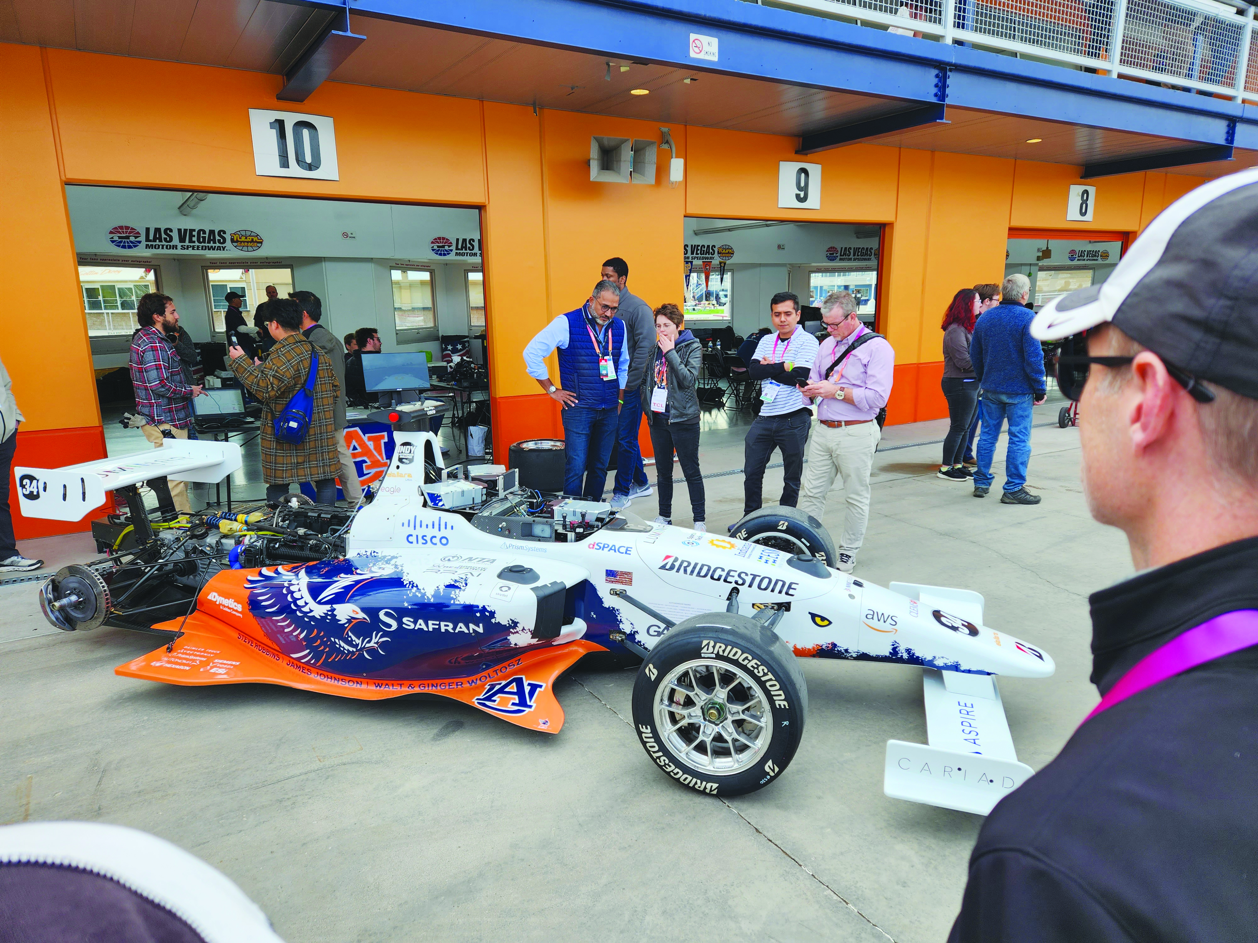
Safran and auburn university students are pictured with their autonomous F1 race car that competed in the Indy Autonomous Challenge on the Las Vegas Motor Speedway at CES 2023. Auburn students used Skydel, a Safran simulation engine, to improve the capabilities of the car and to learn how to make it safe and reliable on the track. (Image: Safran Electronics & Defense)
As a part of the program, Safran has a long-established partnership with Auburn University’s College of Engineering. Safran and Auburn University students participated in the Indy Autonomous Challenge, which took place on January 7, at the Las Vegas Motor Speedway during the 2023 Consumer Electronics Show. Nine autonomous Formula 1 race cars, representing colleges and universities from around the world, took part in a head-to-head driverless racing competition with some vehicles reaching speeds of more than 190 mph.
Safran has supported Auburn students before, during, and after this challenge by enabling them to leverage its GNSS simulators, such as Skydel and the GSG-8, which are used in the university’s autonomous vehicle lab. Butler said that giving students access to the simulation software prior to the high-speed races helped them troubleshoot and test the vehicles and improve the results.
“Resolving issues in the lab improves safety while saving time and money,” Butler stated. “The Indy car features multiple antennas. Since Skydel can support multiple instances simultaneously, the team can test heading and realistic scenarios in a simulated environment. This is before they race next to other vehicles at high speeds.
Safran also supports the general advancement of autonomous vehicle technology. Positioning and navigating autonomous vehicles involves the use of multiple technologies, including GNSS.
“Skydel is a valuable tool for the autonomous vehicle industry that wants realistic lab testing because it can support multiple, independent trajectories or antenna outputs simultaneously,” Butler said. She also pointed to the importance of developing mitigation techniques against jamming and spoofing.
“Using a simulator with the Skydel engine allows the user to test in all sorts of challenging environments before putting the wheels on the pavement. This lets the user make sure the vehicle is ready for real-world navigation and avoid costly mistakes. It also gives them a chance to practice and develop countermeasures against unintentional interference and malicious actors.”
Butler added that Safran is proud to support students who are helping to develop automated technology.
“Supporting Auburn’s Autonomous Vehicle team is an honor and a privilege. Student research represents the future of our industry,” Butler said. “We are proud to support them and see what they can accomplish with our simulation tools. We are confident that they will be able to gain valuable insights that will help them design, build and test their autonomous vehicles. It is our hope that their hard work will lead to the development of safe, efficient and affordable autonomous vehicles in the future.”
Accelerating mobility
Waymo, based in Mountain View, California, is an autonomous driving technology company. Formerly known as the Google self-driving car project, it was founded in 2009 and aimed to drive more than 10 uninterrupted 100-mile routes autonomously.
Its first fully autonomous ride on public roads took place in 2015, then Waymo became an independent self-driving technology company in 2016. It launched its first public trial of autonomous ride-hailing vehicles, called Waymo One, in Phoenix, Arizona in 2017, and has expanded its completely autonomous ride-hailing service trials to Scottsdale, Arizona, as well as San Francisco and Los Angeles.
The Waymo vehicle fleet also became fully electric this year.
360° Lidar, Radar, and cameras make up most of the technical elements of the fifth-generation Waymo fully autonomous vehicles. They also have redundant steering and braking, backup power systems, redundant inertial measurement systems for positioning, and more. (Image: Waymo)
Driving Change
According to its website, Waymo “represent[s] a diverse set of communities and interests, and we are coming together because we all share the belief that autonomous driving cars can save lives, improve independence, and create new mobility options.”
Some of Waymo’s community partners include Bike MS, the Arizona Council of the Blind, the Foundation for Senior Living, and Mothers Against Drunk Driving.
One community story to note is Waymo’s partnership with First Pace AZ — a supportive housing community for adults with autism, Down syndrome and other types of neurodiversity — to explore how Waymo could aid neurodiverse people.
Eli is a resident of First Place AZ and an adult with neurodiversity. He does not drive and relies heavily on ride-hailing services, carpooling, and the train to get to work and to volunteer. Not all public transportation is always available or accessible at certain hours. Additionally, human-driven rideshare and carpooling services can present bias from drivers and other passengers who do not understand the behavioral nuances of people who are neurodiverse.
To test the autonomous ride-hail Waymo One system, Eli and Natasha Grant, director of workplace and community inclusion at First Place AZ, hailed a ride to a local animal shelter.
After using the Waymo One service, Eli believed Waymo’s technology could help him stay connected to his community, wherever he may live in the future. Grant added that autonomous vehicles provide independence for individuals who may otherwise not be able to go to places to which they want and need to go.
Breaking social barriers
Community partners that fight food insecurity use Cruise’s autonomous vehicles to pick up left over food from businesses. (Image: Cruise)
Cruise is a self-driving car company based in San Francisco, California, and offers driverless rides in San Francisco; Austin, Texas; and Phoenix, Arizona. It was founded in 2013 by Kyle Vogt and acquired by General Motors in 2016.
Cruise first offered driverless ride-share services for its employees in 2017. In early 2020, the company began testing those driverless rides on public roads in San Francisco. Later that year, Cruise switched gears and repurposed a portion of its all-electric autonomous vehicle fleet to deliver meals to the community during the COVID-19 pandemic. It also began self-driving delivery trials in Arizona.
In 2021, Cruise announced plans for international driverless testing and expansion in Dubai and Japan. The next year, it opened its fully driverless service to public riders in San Francisco.
Delivering Hope
Cruise works with several community partners, such as the National Federation of the Blind, the SF-Marin Food Bank, and the San Francisco Giants.
“At Cruise, our commitment to social impact is a vital part of our business and an extension of our mission to improve life in our cities, especially for people underserved by transportation today,” the Cruise website stated.
In June, Cruise partnered with Replate — a nonprofit food rescue platform — to fight food insecurity and food waste in San Francisco and other communities. The partnership aims to use Cruise’s all-electric autonomous vehicle fleet, integrated with a national network of food recovery partnership from Replate, to pick up leftover food from local businesses and deliver it to organizations that help fight food insecurity.
The goal of the partnership is to create a sustainable cycle of food rescue that fights hunger and waste in local communities.
CHC Navigation (CHCNAV) released the LT800H, a rugged and versatile RTK GNSS tablet designed for geospatial and mapping operations in the field.
The LT800H offers users robust outdoor performance, data security and centimeter-level accuracy for a variety of applications, including construction, environmental surveying and any industry in which Android tablets are required.
Featuring a high-performance 1408 channel GPS, GLONASS, Galileo and BeiDou module and a tracking GNSS helix antenna, the LT800H RTK Android tablet offers centimeter-to-decimeter positioning accuracy in challenging environments. It also comes equipped with a 4G modem to simplify connectivity to GNSS RTK network corrections. The technology also offers an eight-hour battery life, allowing users to collect data in the field uninterrupted.
EMCORE Corporation has released the TAC-440 MEMS inertial measurement unit (IMU). The TAC-440 IMU is designed for demanding, mission-critical, rugged environments in a wide variety of defense, commercial, industrial and marine applications.
The TAC-440 features 1°/hr gyro bias and 1 mg accelerometer bias stability with very low 0.05°/√hr angle random walk over a wide temperature range. The solid-state quartz sensors and hermetically sealed IMU construction provide reliable MTBF and storage life, EMCORE states.
The TAC-440 supports four data message synchronization methods with either input synchronization pulse capability or an output time of validity capability. The user can choose whether the synchronization pulse is internally generated and output as a time of validity of the output data or whether the TAC-440 software will identify the synchronization pulse input and synchronize the output data to the input pulse.