Spirent has concluded a review of Xona Space Systems’ PULSAR production signals, and has deemed them feasibile for integration into the SimXona product line. Spirent will integrate the Xona production signals as an evolution of the SimXona platform.
Support will become available to existing and new users throughout 2024.
Xona is developing PULSAR, a high-performance positioning, navigation, and timing (PNT) service built on low-Earth orbit (LEO) small satellites. Xona’s high-powered smallsat signals aim to improve PNT resilience and accuracy by augmenting GNSS while operating with an independent navigation and timing system architecture.
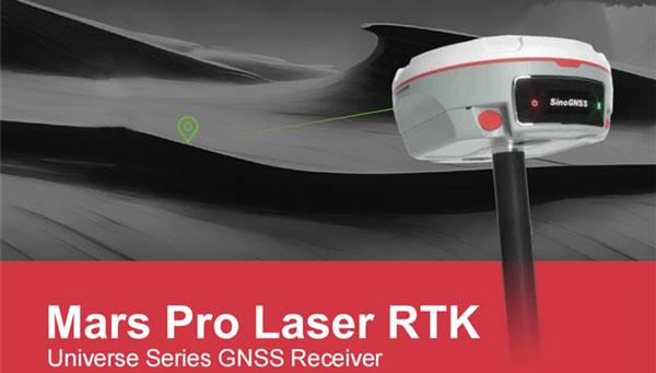
ComNav Technology Ltd. has introduced the Mars Pro Laser RTK, the latest addition to its Universe Series GNSS receiver lineup, which includes the Venus Laser RTK and Mars Laser RTK. This GNSS receiver is suitable for land surveying, GIS, and construction industries with its innovative features.
The Mars Pro’s laser mode helps in signal-blocked, hard-to-reach or hazardous areas, where conventional GNSS receivers struggle. By switching to laser mode, users can effortlessly use the laser distance meter on the back of the Mars Pro to determine the distance between the receiver and the point. The effective distance of the laser is up to 10 m, ensuring signal-friendly accuracy even in GNSS-challenged places, such as in a garage, under a bridge, over the water, or in traffic.
Additionally, the integrated inertial measurement unit sensor provides up to 60°tilt compensation, ensuring efficiency and accuracy in conventional mode and laser mode.
The Mars Pro has full-constellation capabilities with 1,668 channels across GPS, GLONASS, Galileo, BDS, QZSS, and IRNSS. Support for precise-point positioning service ensures rapid fixing. Its OLED color screen also offers real-time data visualization, enhancing operational control.
The Mars Pro supports communication via Wi-Fi, 4G, and Bluetooth, enabling easy data exchange and interaction. It’s compatibility with mainstream brands and multiple protocols makes it versatile and multifunctional. It can transition between roles as a rover and a base and collaborate seamlessly with users.
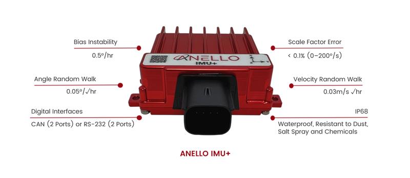
ANELLO Photonics has released the ANELLO IMU+ for robust and reliable autonomous navigation and positioning in GNSS-denied or GNSS-compromised environments.
Powered by optical gyroscope technology, the ANELLO IMU+ delivers high precision and reliability in demanding conditions, including shock, vibration, electromagnetic interference and temperature. The ANELLO IMU+ is suitable for autonomous applications in the construction, robotics, mining, trucking and defense industries.
The device delivers long-term dead reckoning in high-temperature and high-vibration environments.
The ANELLO IMU+ features unaided heading drift of < 0.5°/hr, dual high-speed CAN FD interfaces, and dual RS-232 interfaces; has ASIL-D ready, automotive-qualified CPU and OS; and is IP68 waterproof, resistant to dust, salt spray and chemicals.
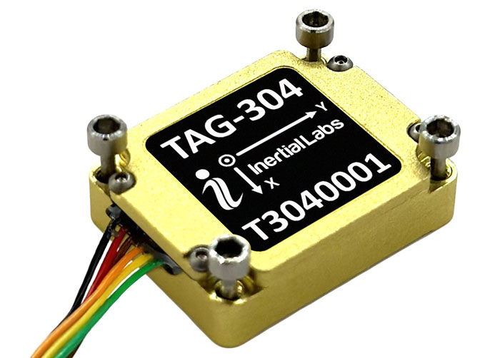
Inertial Labs has released the TAG-304, a three-axis gyroscope solution designed to stabilize platforms where low latency, wide bandwidth, high data rate, and low noise are required.
The TAG-304 gyroscopes can withstand extreme shock and vibrations in accordance with MIL-STD-810. Additionally, the gyroscopes are fully digitized (RS-422 interface), include built-in test functionalities, and have no moving parts.
The solution is a tactical-grade MEMS gyroscope designed for harsh environments and
tasks requiring accurate stabilization of assorted platforms. TAG-304 also features low latency (group delay), small size, 4K Hz data rate, 1K Hz bandwidth, and low noise, making it ideal for miniature electro-optical systems, gimbals, line-of-sight, and pan and tilt platforms stabilization and pointing applications.
JAVAD GNSS’ Triump-1M Plus receiver has 874 channels for acquiring all available GNSS satellites and patented mobile antenna technology for robust UHF and cellular communications. (Image: JAVAD)
As most readers of this magazine know, GPS, like the other three GNSS, consists of three segments: the space segment — i.e., the satellites; the control segment — i.e., the monitoring and control stations on the ground around the world; and the user segment — i.e., the receivers. The first two are developed, operated and maintained by the U.S. Space Force, while the third one, for civilians, is totally in the hands of the private sector.
Most of the progress in receivers is evolutionary, with rare dramatic changes. To provide a snapshot of the current state of GNSS receivers, I asked several manufacturers three questions. What follows are short, etre dited excerpts of their answers that showcase the applications of GNSS receivers in a wide range of industries.
What is one of the most recent end-user applications for your receivers? What challenges does it pose and how do your receivers address them?
Sarah Alban (SA): Eos Positioning Systems is lucky to have innovative customers who span a variety of industries. In just these past few weeks, we’ve connected to customers who are using Arrow Series GNSS receivers to meet myriad business needs. Here are just a few examples: On the Caribbean island of Martinique, Odyssi uses an Arrow 100+ with RTK to get accurate water utility locations in a challenging environment. In Texas, midstream pipeline operator Kinetik and its GIS Manager Papillon Romero equip their field workers with an Arrow Gold to update the locations of previously unreliable legacy as-builts. In the Galápagos Islands, a researcher has been using the Arrow Gold+ and Galileo High Accuracy Service (HAS) to georeference drone imagery. In Colorado, GIS specialist Jim Casey uses an Arrow Gold to bring to life a Japanese internment camp in augmented reality.
Simon Baksh (SB): One of our customers is a leading construction contractor who uses our DELTA GNSS receiver for monitoring during deep crack grouting deformation to ensure that the natural state of the ground remains undisturbed during remedial work.
Stephen Ching (SC): One of the most exciting projects happening within Hexagon’s Autonomy & Positioning division is the automated road train platooning application within the mining industry. Transporting raw materials, iron ore in this case, has posed a huge challenge in terms of drivers’ safety, labor shortages and rising fuel costs. Our division is currently developing an autonomous hauling system that solves this challenge by integrating drive-by-wire, perception, positioning and path planning technologies. Our positioning system utilizes a PwrPak7D-E2 plus TerraStar-C PRO solution from Hexagon | NovAtel, which incorporates GNSS+INS technology and real-time kinematic (RTK) From the Sky technology.
Mobile mapping systems such as the Trimble MX50 allow survey companies to safely and accurately gather point cloud and immersive imagery of roads without the need to put a surveyor in the field. (Image: Trimble)
Karl Bradshaw (KB): Traditional survey methods or tripod-based scanning on highways can be time-consuming and dangerous. Survey companies do not want to put surveyors in danger of traffic while traversing along a road. Mobile mapping allows them to safely, accurately and productively gather detailed point cloud and immersive imagery of highways without needing to put a surveyor in the field.
Oreste Concepito (OC): At u-blox, we have seen an increasing demand for GNSS receivers to be used for advanced driver-assistance systems (ADAS) applications and for mobile robotics (such as robotic lawnmowers). GNSS technology is adopted when an accurate, trustworthy position with high availability is required. In the autonomous operations domain, customers are constantly pushing u-blox to improve dependability while maintaining or ideally improving position accuracy, even in challenging environments.
François Freulon (FF): One of our most recent end-user applications is related to resilient timing for mission-critical infrastructure, including finance, data centers, energy and telecommunications. The relevant Septentrio product is the mosaic-T. The recent addition of the AtomiChron timing service further enhances its timing precision, GNSS resilience and anti-spoofing by offering navigation message authentication (NMA) on all for GNSS constellations. The first customer integrating this technology is Meinberg.
Miles Ware (MW): The Galileo High Accuracy Service (HAS) has created new interest in a traditional GNSS market, GIS and mapping, in which the availability of global 20 cm accuracy is turning many heads. While there are many technologies to improve accuracy for this market, few are appropriate. Often the work takes place in remote areas where cellular connectivity is not available for delivering corrections. They may also be in regions of the world where satellite-based augmentation systems (SBAS) are not available or able to meet performance expectations. Galileo HAS resolves both of these concerns. We now support it in our Phantom and Vega receivers.
In the past few years, we have seen the completion of two new GNSS constellations and a large increase in the options for corrections services. How has this impacted the design and/or features of your receivers?
SB: Our 874 channel TRIUMPH ASIC design has capacity for all constellations and signals to utilize current and future GNSS technologies. Additionally, our J-Star PPP Service using geostationary satellite broadcast for global delivery and cm level positioning extends operations to remote areas where networks are absent or where a base station setup and operation is not feasible.
SC: With BeiDou and Galileo in addition to GPS and GLONASS, there can be upward of 40 satellites in view — compared to 20 years ago when having 10 or 12 satellites in view was considered good availability. This gives much more choice as to which measurements contribute to a position solution, provided that the receiver can make measurements to all the satellites in view. Hexagon | NovAtel’s OEM7 was designed to support all GNSS constellations and frequencies, which required supporting many channels as well. The benefits of more satellites in the sky come under challenging conditions with many obstructions and strengthened positioning geometry in unobstructed conditions. In addition to more satellites, BeiDou and Galileo also introduced a new frequency at E6/B3, in addition to L1/L2/L5, which is particularly useful in global PPP solutions, such as RTK From the Sky and TerraStar C-PRO Correction Services.
KB: We have onboarded these constellations into our mobile mapping portfolio in the same way as all other Trimble GNSS portfolios, through rigorous, tried and tested methodologies.
FF: Septentrio receivers already support all GNSS constellations for high precision and resilient positioning. We have added Galileo E6 support and OSNMA, BeiDou phase III satellites (PRN>37) and other new signals (B3I, B2b) to our products through our latest firmware releases. We are also contributing to the large increase of corrections services by providing the backend core technology through our base station receivers or reference receivers. For example, the PolaRx5 reference receivers are used worldwide in many correction network infrastructures. With the support of all in view constellations and signals, Septentrio products are becoming part of critical infrastructure. Therefore, it is essential they have reliable continuous operation as well as security to protect them from potential jamming or spoofing attacks. Additionally, Septentrio has recently launched the Agnostic Corrections Partner Program to help customers find their way in the growing maze of correction offerings and to facilitate the integration of the right service into their system.
Geneq Inc. employee Alex Arsenault operating an SXblue Platinum receiver in Anjou, Montreal. (Image: Nikita Sapeguine / Geneq)
OC: Our customers are increasingly operating in a global market. To respond to that need, u-blox receivers support both the global and the regional constellations, such as Japan’s Quasi-Zenith Satellite System (QZSS) and India’s Indian Regional Navigation Satellite System (IRNSS, aka NavIC). The offer for correction services has also evolved to be able to serve the global market, moving toward uni-directional streams, possibly distributed via L-band. We support a complete portfolio of correction services, responding to all commercial and performance requirements, from the soon available, free-of-charge, lower accuracy correction services, up to the dm-level functional safety-certified correction services for autonomous driving.
MW: Since 2019, our core receiver technology has been intrinsically both multi-GNSS and multi-frequency by design. This allows our engineering team members to rapidly adapt to new and emerging solutions, and for Hemisphere to meet user and market demands. Hemisphere has also worked with our integrators to recognize the need to simplify the decision process around selecting receivers. While it is possible to configure our receivers to track specific constellations only, Phantom and Vega are being offered with multi-GNSS as standard. Similarly, clients can choose L1-only, or all-frequencies. This is why many integrators will quickly be able to take advantage of Galileo HAS.
RP: We have upgraded our SXblueGPS receivers with new GPS chips and with firmware updates to keep up with the new constellations available. Regarding the new correction services, the SXblueGPS have used and use by default the SBAS correction service and its associated networks throughout the planet to improve their precision. Where correction services via internet or SBAS do not exist, they use L-band correction services to have global coverage. In some cases, for topography base and mobile solutions, UHF links provide a customized correction service.
Are jamming and spoofing significant challenges in your key markets? If so, how do you address them?
SB: Yes, and AJ/AS expands on existing RAIM for assured position quality. Patented anti-jamming and anti-spoofing techniques identify and suppress GNSS interference, while maintaining navigation from good signals. Updated firmware for Navigation Message Authentication extends AJ/AS protection further.
SC: GNSS interference such as jamming and spoofing do present significant positioning challenges in many of our markets, especially defense, marine and autonomy applications in which safety and 24-7 operation are paramount. How often GNSS interference happens (and is detected) and how seriously it affects the application depends on the market. It is a threat that can be mitigated by well-designed user equipment. Hexagon | NovAtel has developed a comprehensive GNSS resiliency portfolio to assure that our users’ position is protected with our interference mitigation technology, starting from the GAJT antennas all the way down to the receiver level. NovAtel’s OEM7 receivers include our GNSS Resilience and Integrity Technology (GRIT) firmware options, which provides spoofing detection, interference detection, and mitigation with digital filters, as well as time-tagged digitized samples for advanced situational awareness.
KB: As it applies to mobile mapping with the Trimble MX50, jamming and spoofing are not significant challenges.
OC: A team of engineers is constantly improving our anti-jamming and anti-spoofing technology. U-blox customers are today more mindful of the risks associated with GNSS interference, both intentional and unintentional. GNSS is adopted in critical infrastructures and autonomous vehicles, where jamming and spoofing could lead to severe consequences. While no system can be safe in absolute terms, increasing the sources of information can greatly improve the resilience against jamming and spoofing attacks. Multi-constellation GNSS receivers, multi-band constellations, inertial sensors and accelerometers, can all be individually used as additional safety layers contributing to a more robust solution. Additional measurements are implemented at the positioning engine level, as part of our functional safety program. The availability of authenticated signals, being introduced by Galileo’s Open Service – Navigation Message Authentication (OS-NMA), will also contribute to increasing the GNSS robustness against interference.
Hemisphere GNSS’ GradeMetrix is a machine guidance solution for GNSS-based machine control and guidance applications. (Image: Hemisphere)
FF: Definitely, and we are seeing a large increase in demand for resilience in many applications and for assured positioning, navigation and timing (PNT). Providing trustworthy information is critical now for many markets, such as machine control, robotics, timing, infrastructure and assured PNT. Our multi-frequency multi-constellation GNSS technology not only maximizes accuracy and availability in areas where the sky is partially obstructed, but also provides extra resilience against jamming and spoofing. All our GNSS receivers are resilient to jamming and spoofing thanks to the built-in Advanced Interference Mitigation (AIM+) technology, which suppresses the widest variety of interferers, from simple continuous narrow-band signals to the most complex wideband and pulsed transmissions.
MW: Fortunately, jamming and spoofing are not common occurrences in most of our markets. However, their nature is such that they can appear at any time, in any place, without warning. This can cause otherwise routine plans for users to suddenly grind to a halt. Hemisphere’s Cygnus interference solution provides protection against up to 60 dB of jamming and is built into our current generation products by default. Having Cygnus available can make the difference between working normally and searching for alternate solutions. A welcome tool offered through Galileo satellites is OS-NMA signal verification, which provides excellent protection against spoofing attacks. Firmware updates provide our current product platforms access to OS-NMA spoofing protection. As our standard products are already activated for multi-constellation operation, it simplifies integration for our users.
RP: Interference is inevitable given the enormous number of signals from telephone and electrical networks, among others, as well as buildings, trees and, of course, the weather. To mitigate this, we use multi-frequency and multi-GNSS antennas that allow us to obtain the best reception in areas of interference. Additionally, we have state-of-the-art GPS chips that block and purify signals that generate distortion. On the other hand, there is interference by intentional GNSS falsifications or by radio amateurs who transmit radio signals for drones and other devices that cause GPS signal loss, which are mitigated by the latest technology algorithms of our SXblueGPS.
The Mobile World Conference (MWC) returns to the Las Vegas Convention Center on September 26 to 28, 2023.
The event will feature exhibition from major U.S. operators, including AT&T business, T-Mobile business, and Verizon business as well as new sessions dedicated to sports and entertainment, software developers and the GSMA’s SEC CON event.
MWC, in partnership with the Cellular Telephone Industries Association (CTIA), invites industry leaders and attendees to connect and discuss topics such as the industry’s transition to a circular economy, the future role of artificial intelligence (AI) in society, and what comes after 5G.
To reflect the United States’ position as a global technology hub and a market at the forefront of 5G innovation, the event is centered around four key themes:
5G Acceleration, as adoption explodes to become the most common mobile technology in North America by 2025.
Age of AI, as the world awakes to the opportunities and challenges of generative AI.
Digital Everything, as the expansion of digital technologies is felt across every industry, from sports and entertainment to manufacturing, financial services and smart mobility.
Enterprise Mobility, as the revolutionary phase of 5G in enterprise is well underway.
The event will feature a variety of keynote speakers, including Amanda Toman, the director for the Public Wireless Supply Chain Innovation Fund at the National Telecommunications and Information Administration (NTIA) within the U.S. Department of Commerce.
For the first time, the GSMA will bring its SEC CON event to MWC Las Vegas on day two, welcoming leading security experts to explore the importance of keeping telecoms infrastructure secure in times of conflict.
A full directory and registration can be found on the MWC Las Vegas website.
Last month’s column highlighted GEO-ESCON and how it supported the advancement of the science of geodesy. That said, the National Geodetic Survey (NGS) has been working to improve the National Spatial Reference System (NSRS) by replacing the North American Datum of 1983 (NAD 83) frame and all vertical datums, including the North American Vertical Datum of 1988 (NAVD 88), with four new terrestrial reference frames and a geopotential datum. Many of my previous GPS Worldcolumns have addressed various phases of the project.
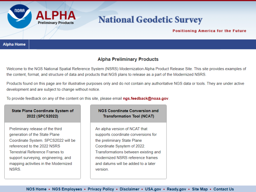
Recently, NGS has developed an Alpha site to enable users to preview preliminary NSRS products and services. I mentioned the Alpha site in my July column, in which I highlighted NGS’s presentations on the new NSRS at the International 2023 FIG Working Week.
Alpha preliminary products page. (Image: NGS)
The concept of the Alpha site is to provide examples of the content, format, and structure of data and products that NGS plans to release as a part of the modernized NSRS.
NGS highlights that these products are for illustrative purposes only and do not contain any authoritative NGS data or tools. It states that they are under active development and are subject to change without notice.
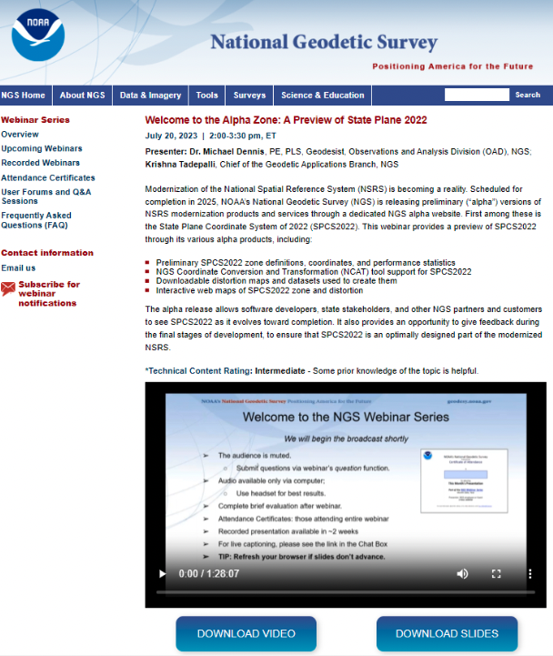
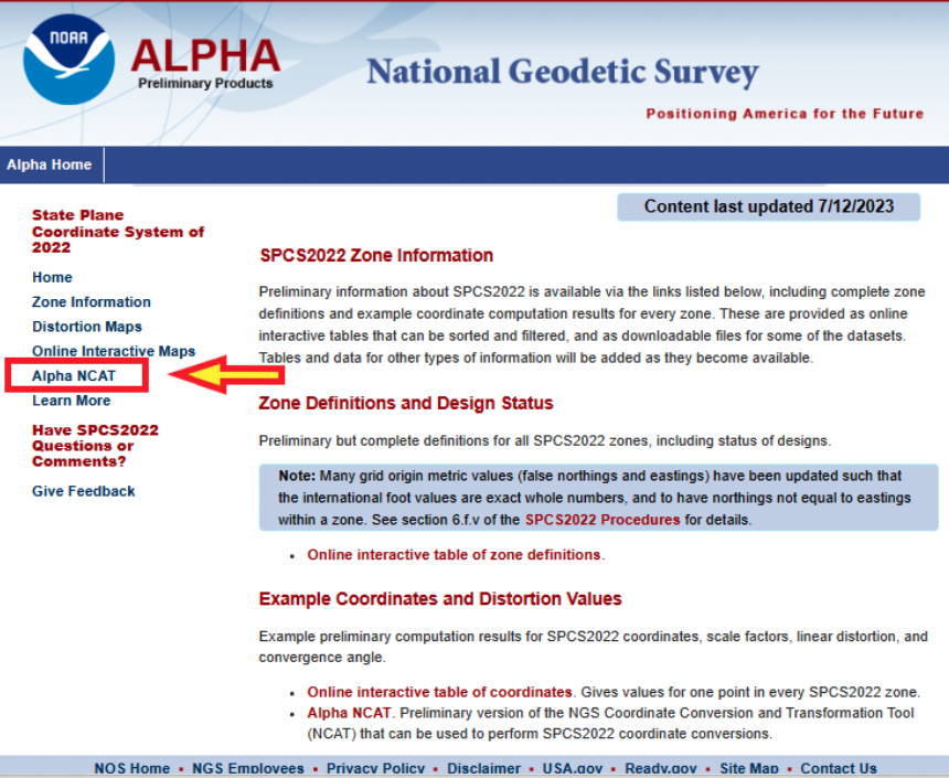
That said, NGS would like everyone to try the Alpha products and provide feedback to NGS. The first two Alpha products are State Plane Coordinate System of 2022 (SPCS2022) and NGS Coordinate Conversion and Transformation Tool (NCAT). On July 20, NGS held a webinar previewing the Alpha site. Readers can download the powerpoint and video of the presentation here.
Webinar on preview of SPCS2022. (Image: NGS)
As usual, Michael Dennis of NGS did a great job of describing the new SPCS2022, and the differences between the State Plane Coordinate System of 1983 (SPCS83) and SPCS2022. I have included a few of his slides that highlight the SPCS2022.
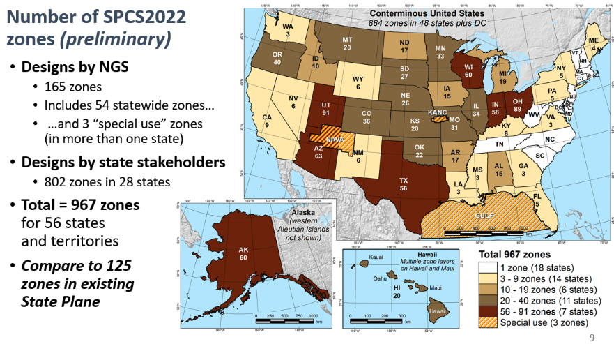
First, SPCS2022 has significantly more zones than the current SPCS83 zones. Second, SPCS83 map projections were designed to minimize linear distortion at ellipsoid surface, whereas the SPCS2022 map projections were designed to minimize linear distortion at topographic surface. The purpose being to reduce the difference between projected “grid” and “actual” ground distances.
Number of SPCS2022 zones. (Image: NGS)Linear distortion of SPCS2022. (Image: NGS)
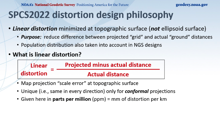
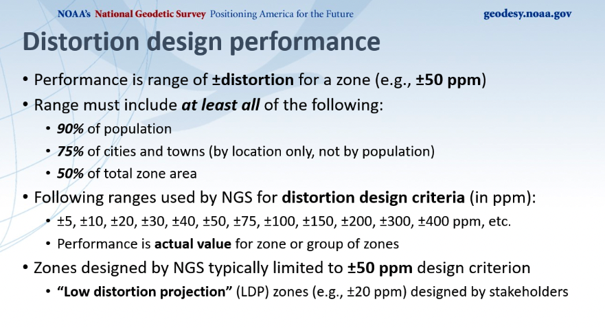
Dennis described NGS’s distortion design performance as seen in the image below. He explained that the performance is a range of +/- distortion for a zone, such as +/-50 ppm. The analysis involved determining parameters where the range includes 90% of the population, 75% of the cities and towns, and 50% of the total area. He highlighted those zones designed by NGS that where typically limited to +/- 50 ppm design criteria, but many low distortion projections (LDP) zones designed by stakeholders consisted of +/- 20 ppm design criteria.
Distortion design performance. (Image: NGS)
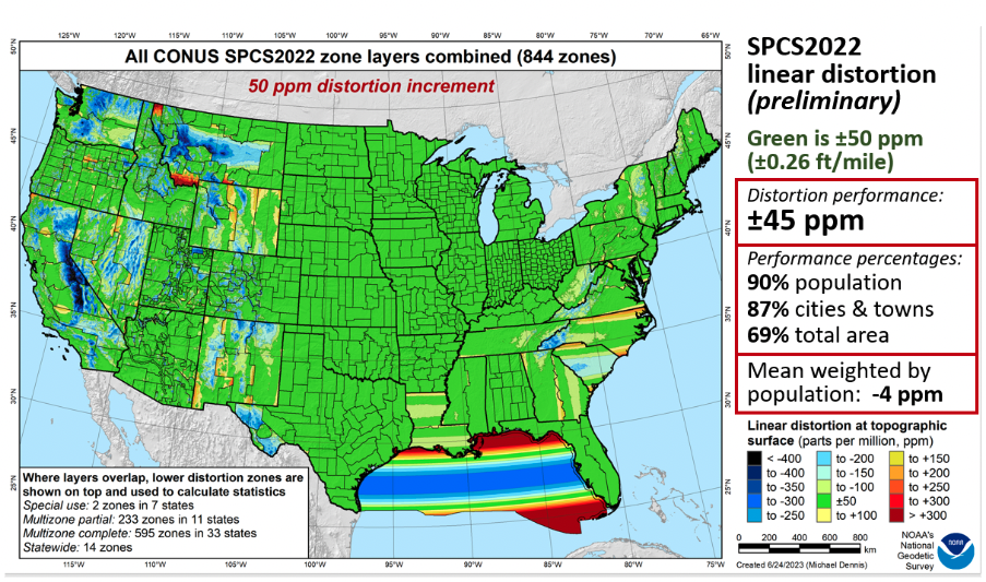
Dennis provided a slide depicting SPCS2022 linear distortion for all CONUS zones with a 50 ppm distortion increment as seen below. As indicated on the slide, green is +/- 50 ppm. The distortion performance is +/- 45 ppm.
All CONUS SPCS2022 zone layers. (Image: NGS)
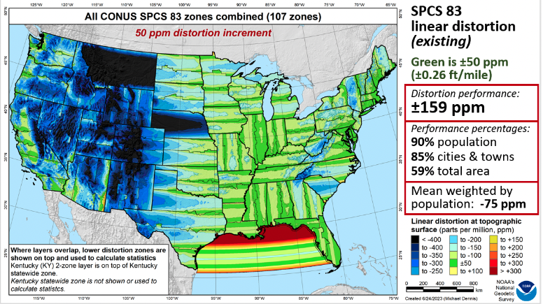
As a comparison to the existing SPCS83 zones, he provided a similar slide for the CONUS SPCS83 zones. See below. As in the previous slide, green represents +/- 50 ppm. The distortion performance is +/- 159 ppm.
All CONUS SPCS83 zone layers. (Image: NGS)
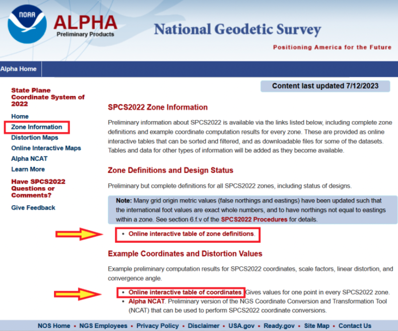
Now, let us look at the Alpha products. First, all zone information can be found here.
SPCS2022 zone information. (Image: NGS)
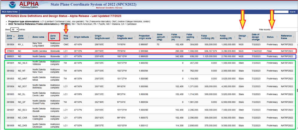
Users can click on the image below for a table of all zone definitions. The table provides the type of projection, if it was designed by NGS or the state, and the zone definition.
Online interactive table of zone definitions. (Image: NGS)
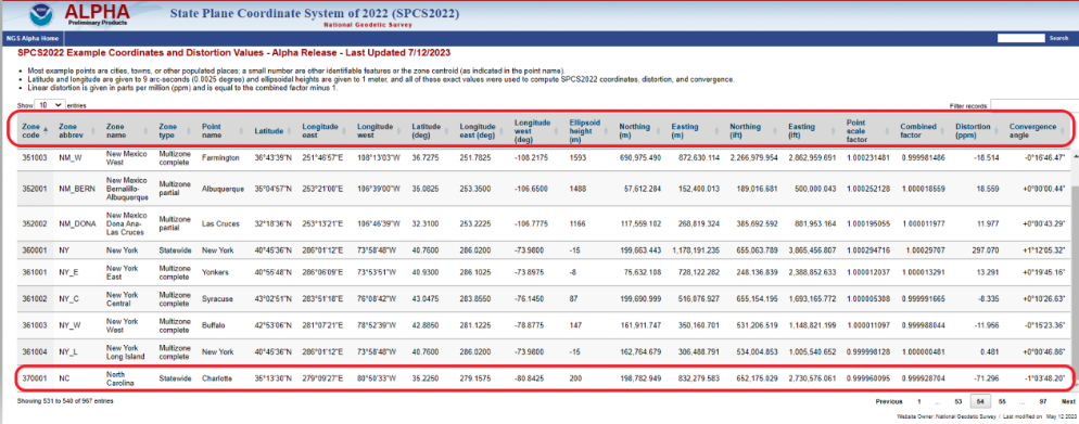
By clicking on the image below, users can obtain information for a point in a particular zone. The table provides northing and easting (meters and feet), scale factor, linear distortion, and convergence angle for a specific coordinate in a particular zone. It should be noted that all values that are provided in feet will be international feet units (ift).
SPCS2022 example of coordinates and distortion values. (Image: NGS)
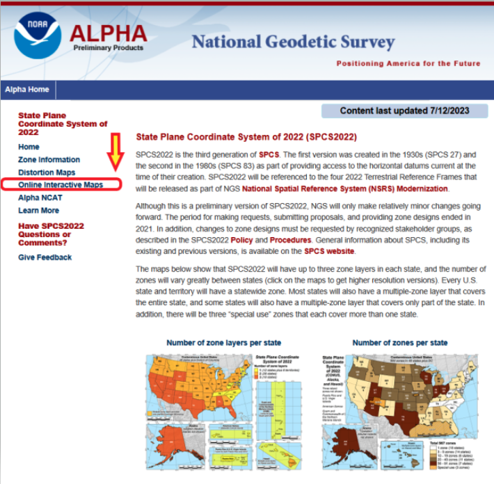
The Alpha page provides an online option to look at all maps. The arrow in the image below highlights the link to access the online interactive maps.
Alpha page for SPCS2022. (Image: NGS)
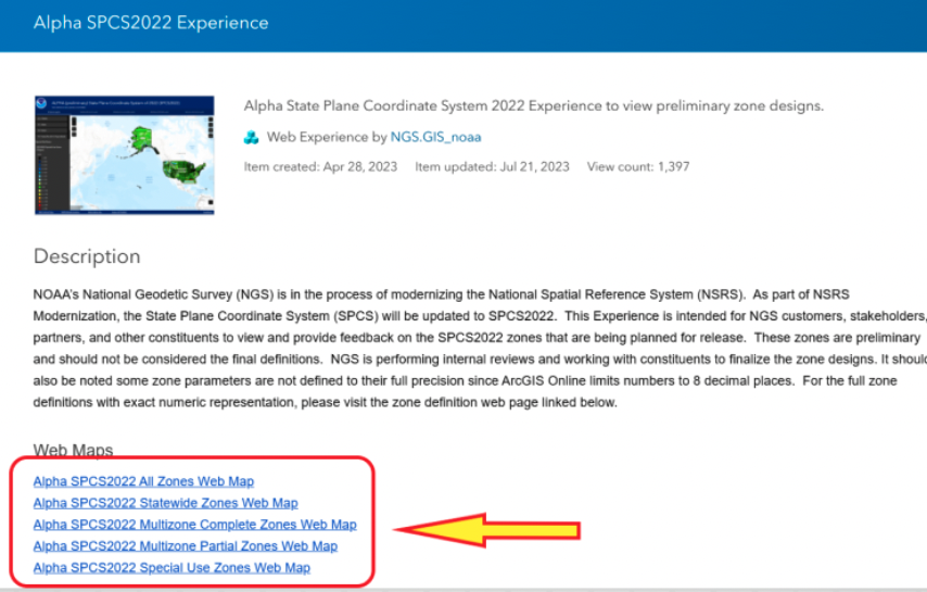
When users click the link on the page, they are directed to an ArcGIS NOAA web map viewer.
Alpha SPCS2022 experience. (Image: NGS)
To access the online map function, users need to click one of the Alpha SPCS2022 zone options.
Alpha web maps. (Image: NGS)
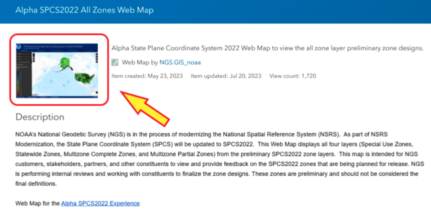
Once users click on one of the web map buttons, another map page with a map icon appears on which userswill need to click to get to the map of zones.
Alpha SPCS2022 all zone web map. (Image: NGS)
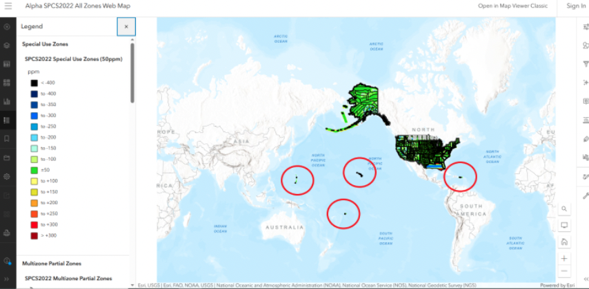
After users click on the map icon, they will get another web page that contains the map zones based on their selection. In my example, I selected “all zone web map.” Once users get to this page, they can zoom into any area to find a particular zone.
All zone web map. (Image: NGS)
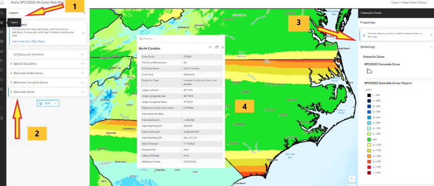
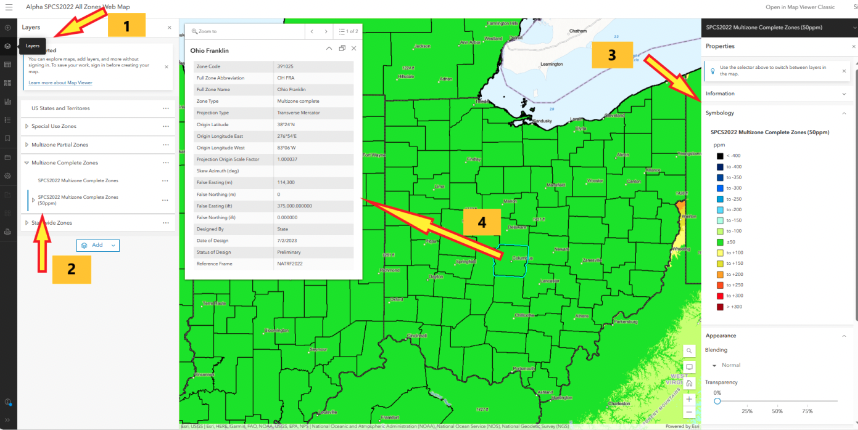
I zoomed down until I located North Carolina’s map zone. The web page provides access to various layers and information. First, if users move their curser over the layer button, a list of layers pops up. Next, select one of the layers, such as Statewide Zones, then the properties of the map are placed on the map. Finally, when readers click on the map itself, the information about the SPCS2022 zone appears on the map.
Alpha North Carolina Statewide Zone web map. (Image: NGS)
North Carolina is a state that elected to have a single statewide zone. Some states decided to design several LDPs that cover certain areas or cover the entire state. Ohio is a state that designed 89 LDPs that cover the entire state. Again, by selecting the layer button, users have an option to select multizone complete zones, the properties appear on the map, and finally clicking on the map provides the zone information for that zone. In this example, I clicked on Columbus, Ohio, which is in the Ohio Franklin Zone.
Alpha Ohio multizone complete zones web map. (Image: NGS)
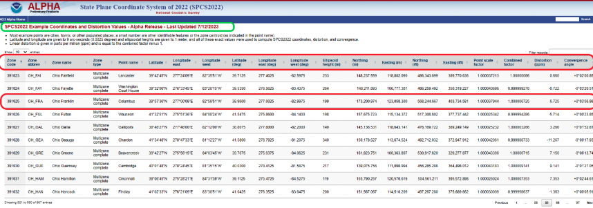
Users can obtain specific information for a coordinate located in the Ohio Franklin Zone by clicking on the online interactive table of coordinates. Note that the distortion is 6.725 ppm at the coordinate in the zone.As previously stated, this was a user–defined LDP zone.
SPCS2022 example of coordinates and distortion values in Ohio Franklin Zone. (Image: NGS)
Another Alpha site available for users to evaluate is the NGS Coordinate Conversion and Transformation Tool (NCAT). NCAT is probably the tool that most surveyors will be interested in using and providing feedback to NGS. Users can access NCAT on the Alpha SPCS2022 webpage or by clicking here.
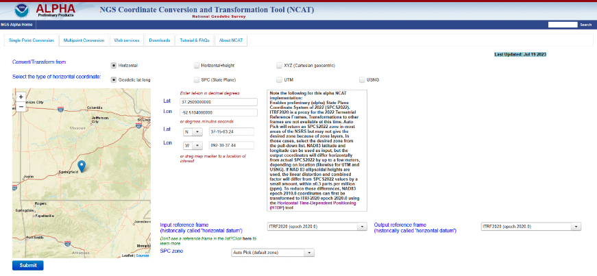
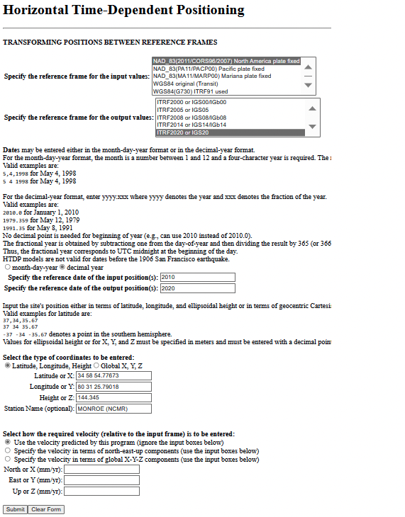
The Alpha NCAT website has a note about the coordinates that users should provide as input to the routine. The bottom line is that the input coordinates need to be in ITRF2020 (epoch 2020.0), or readers may not get their desired zone. NGS recommends that users convert the coordinates to ITRF2020 (epoch 2020.0) using the Horizontal Time-Dependent Positioning (HTDP) tool.
Users can access HTDP here. I provided an example of HTDP for a CORS in North Carolina. I used the NAD 83 (2011) [epoch 2010.0] published coordinates of the CORS as my input values.
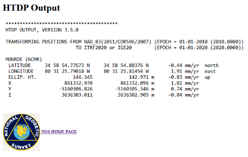
Example of a HTDP computation. (Image: NGS)Output of a HTDP computation. (Image: NGS website)
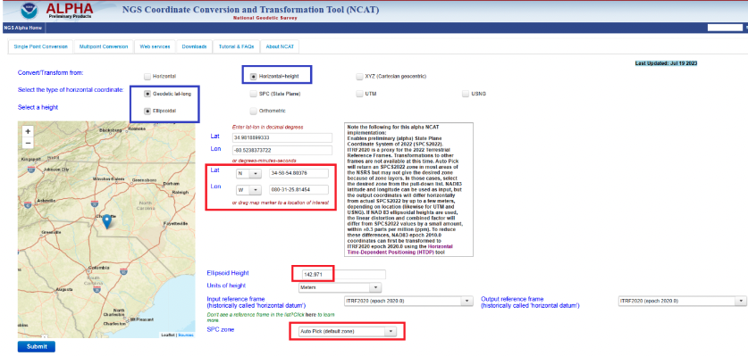
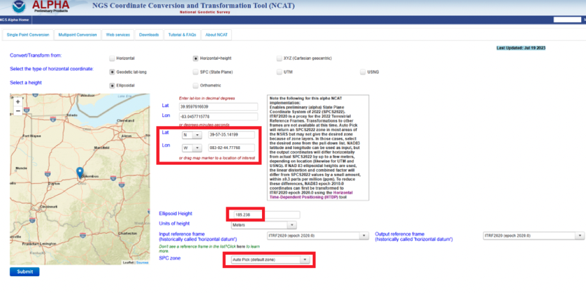
After using HTDP to transform the coordinates from NAD 83 (2011) to ITRF2020, I used the Alpha NCAT tool to compute the SPCS2022 values for the mark. I provided an example of the Alpha NCAT routine using the coordinates of the North Carolina CORS NCMR. The program defaults to horizontal only, so I changed it to the horizontal-height option. The user then enters the latitude, longitude, and height of the mark. Lastly, the user has an option to select the SPC zone or the program will select the zone based on the coordinates of the mark. In my example, I selected the auto pick option.
NCAT input for MONROE CORS (NCMR). (Image: NGS)
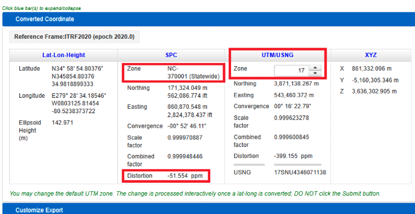
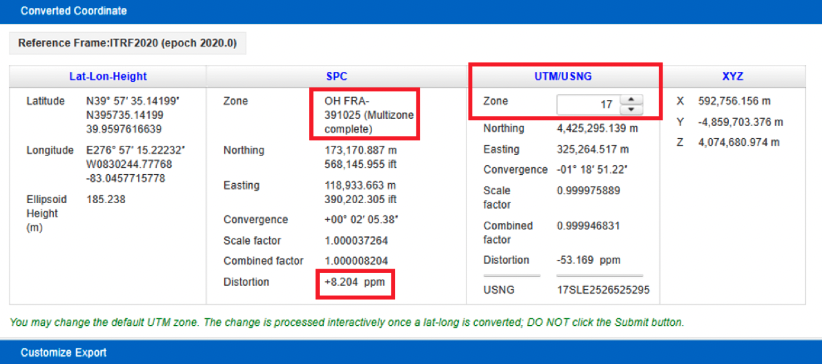
The image below provides the output of NCAT. I have highlighted a few items in the image. First, the program selected North Carolina’s Statewide Zone, the distortion is -54.554 ppm at this mark, and the UTM zone selected is Zone 17. The output also provides the scale and combined factors.
NCAT output for NCMR. (Image: NGS)
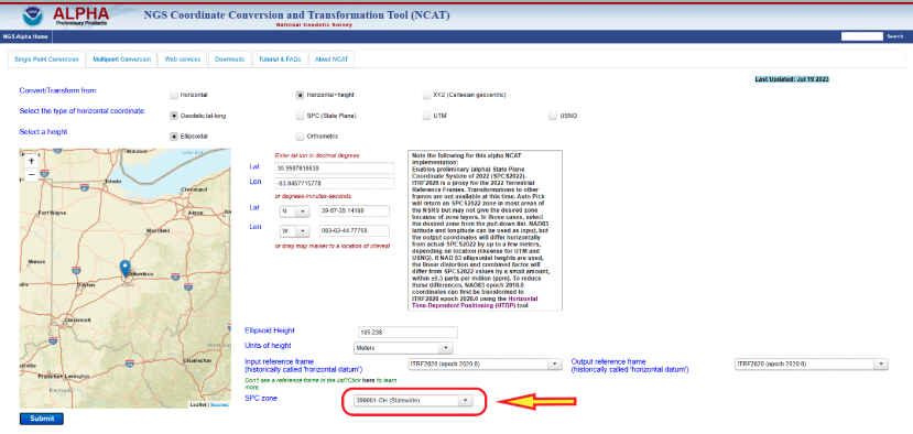
North Carolina is a state that elected to have a single statewide zone, but, as previously mentioned, some states decided to design their own LDPs. Again, Ohio is a state that designed LDPs that cover the entire state. Once again, I entered the coordinates into the input boxes and selected the auto pick (default zone) option. As indicated in the converted coordinates section, the program selected the OH FRA-391025 zone based on the coordinates of the mark. Notice that the distortion is only +8.024 ppm.
NCAT results for Columbus CORS (COLB). (Image) NGS)
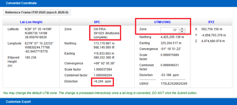
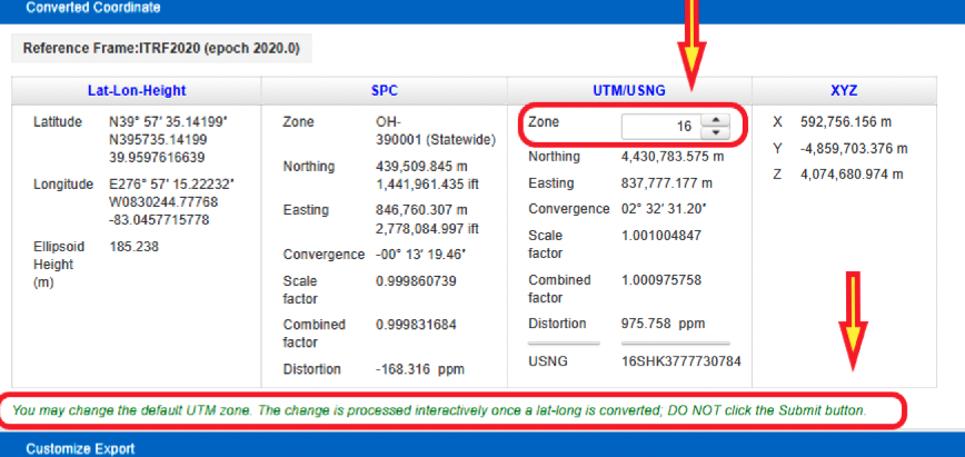
The user has the option to select a different zone than the default zone. The image below provides the SPC values for the COLB mark when selecting the Ohio Statewide Zone. Notice that the distortion value changes from +8.024 ppm to -168.316 ppm. Also, as expected, the UTM and X, Y, and Z values have not changed.
NCAT results for COLB selecting Statewide Zone. (Image: NGS)
One last option to highlight is that the user can change the default UTM zone by clicking on the up or down arrows under the UTM column. In my example, I changed the UTM zone from 17 to 16. Obviously, the values under the UTM column changed.
Option to change default UTM zone. (Image: NGS)
The concept of the NGS’s Alpha site is to provide examples of the content, format, and structure of data and products that NGS plans to release as part of the modernized NSRS. NGS states that these Alpha products are for illustrative purposes only and do not contain any authoritative NGS data or tools. It states that they are under active development and are subject to change without notice.
That said, NGS would like everyone to try these Alpha products and provide feedback to NGS, so that they can improve their products and services. I would encourage readers to try these Alpha sites and provide comments and suggestions to NGS.
Qualcomm has entered a technology agreement with Hyundai Motor Group to integrate its Snapdragon Automotive Cockpit Platform into Hyundai Motor Group’s purpose-built vehicles (PBV).
The infotainment systems on the PBVs will use Snapdragon Automotive Cockpit Platforms for a “holistic, seamlessly connected and smart user experience,” Qualcomm said.
The PBVs are designed to deliver transportation, comfort, logistics, commercial and healthcare services. The latest generation of Qualcomm’s Snapdragon platform benefits from optimized power consumption, high-definition graphics and immersive multimedia and audio.
According to Qualcomm, the latest generation of Snapdragon Automotive Cockpit Platforms offer optimal power consumption while providing top-tier graphics as well as top immersive multimedia and audio experiences.
The platforms offer location services, emergency calling, noise reduction, and dual SIM capability as well as cloud-based monitoring and management systems. Using Qualcomm’s artificial intelligence (AI) engine and machine learning (ML) capabilities for intuitive and intelligent systems, Snapdragon can support digitally advanced applications, including in-vehicle virtual assistance and adaptive human interfaces. It can also facilitate natural communication between the vehicle and passengers for added safety and comfort.
The platform also employs dynamic configuration management to ensure vehicles are kept up to date. Reliable cloud-based vehicle monitoring and management also is possible through cloud service solutions.
Qualcomm and Hyundai Motor Group have been collaborating since 2011 on in-vehicle mobile communications using Snapdragon Automotive Connectivity Platforms.
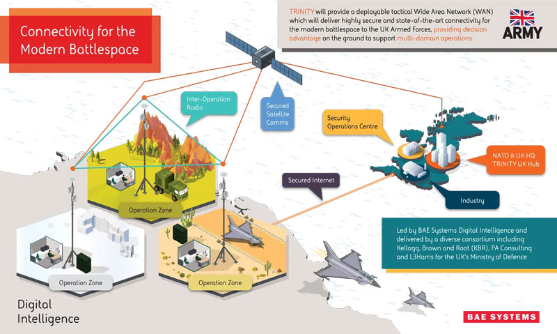
BAE Systems has been awarded an £89 million contract by the Ministry of Defense (MOD) to enhance front-line connectivity for military personnel, UAVs, combat vehicles, fighter jets, aircraft carriers and military commands.
The contract will be dedicated to the research and development phase of BAE Systems’ deployable tactical wide area network (WAN), Trinity. Trinity is due to be delivered in December 2025.
Under the contract, BAE Systems will lead an alliance of trusted partners, including Kellogg, Brown and Root (KBR), PA Consulting and L3Harris, to design and manufacture Trinity. The companies aim to deliver a highly secure battlefield internet capability to UK forces, which will sustain battlefield awareness and intelligence sharing through a myriad of adversarial attacks.
Trinity’s resilience is based on its composition, the company said. It is made up of a series of nodes, each able to add, access and move data in a secure network. If several nodes are damaged in warfare, the remaining automatically re-route to maintain optimum network speed and flow of information.
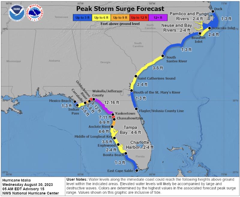
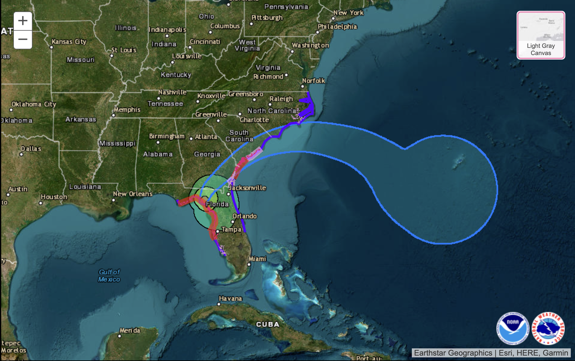
According to the U.S. National Hurricane Center (NHC), Hurricane Idalia made landfall along the Gulf Coast of Florida around 7:45 a.m. EDT on August 30 as a Category 3 hurricane. The NHC is continuing to map the storm’s path, and as of 9:00 a.m. EDT, a catastrophic storm surge was occurring with damaging winds spreading inland over Northern Florida.
Idalia is expected to bring excessive rainfall along its path from Florida through the Carolinas. The heavy rain could shift depending on the storm’s exact path.
Peak storm surge forecast in Florida. (Image: National Hurricane Center)
This hurricane and future storms this hurricane season, have the potential to become supercharged as sea surface temperatures have clocked record high temperatures.
Idalia is the ninth named storm to form in the Atlantic in 2023.
In late May, the National Oceanic and Atmospheric Administration (NOAA) predicted that there would be 12 to 17 named storms this year. However, on Aug. 10, NOAA revised its estimate to 14 to 21 storms.
There were 14 named storms last year, after two extremely busy Atlantic hurricane seasons in which forecasters ran out of names and had to resort to backup lists, reported The New York Times.
Readers can stay updated with Hurricane Idalia at the NHC website.
uAvionix has partnered with Civil Air Patrol (CAP) to deploy a DO-260B-compliant, dual-band Automatic Dependent Surveillance-Broadcast (ADS-B) receiver network to complement Federal Aviation Administration (FAA) sensor data with low-altitude aircraft positions in support of CAP’s radar analysis mission.
The ADS-B receiver technology — already in use in Virginia — is designed to shorten the accident-to-rescue time in the National Radar Analysis Team’s search and rescue efforts.
Through the leadership of CAP’s Virginia Wing, members throughout the state have assisted uAvionix in locating suitable receiver sites and supported the installation of small, low-weight FlightStation ADS-B receivers at various airports.
The dual-mode (1090 MHz and 978 MHz) FlightStations receive transponder data from aircraft, which is centrally received and transmitted to the radar team server at Maxwell Air Force Base, Alabama, where it’s combined with FAA sensor data.
The CAP team uses FAA data and advanced technologies in its search and rescue efforts. The team is activated by the Air Force Rescue Coordination Center when there is a report of a possible missing aircraft or crash. Once the team is activated, analysis and actionable data can be provided in minutes to an incident commander, instead of the days or hours required before the team’s creation.
The FlightLine roll-out consists of several ATC grade ADS-B receivers with overlapping coverage, allowing for validation of transmitted ADS-B data and pinpoint multilaterated positions. Traditional ADS-B and radar concentrate mostly on airports and higher altitudes in support of air traffic control.
Most other available data sources largely exclude coverage for 978Mhz transponders, typically used by general aviation aircraft. Virginia is the first state in the U.S. to have complete coverage down to 500 ft of altitude. The new ADS-B is rapidly expanding to other CAP wings across the U.S.
“The introduction of ADS-B has resulted in a significant improvement of general aviation safety,” said Christian Ramsey, managing director, uAvionix. “Expanding on the FAA coverage at lower altitude and for UAT [universal access transceiver] transponders typically carried by general aviation will further enhance the tools used in safety of life activities such as CAP’ ‘s emergency services mission.”
The radar analysis team is calling on all CAP Squadrons to volunteer to host and install additional receivers where additional coverage is needed. Young said his team will prioritize areas where existing coverage is weak.
For more information and to register your squadron for a FlightStation unit, click here.
Hexagon has partnered with Mineral Resources (MinRes) to provide an autonomous haulage solution for a fleet of 120 fully autonomous road trains in Australia. The company says this will transform safety, productivity and sustainability in the region.
The fully autonomous road trains are a full-site, truck-agnostic solution. The addition of unmanned and autonomous systems will form an essential part of the supply chain for the MinRes Onslow Iron project in Western Australia’s Pilbara region.
The center of the autonomous platooning system is Hexagon’s autonomous solutions stack integrating drive-by-wire technology with an autonomous management system to orchestrate vehicle movement in road train haulage.
“Today’s agreement with MinRes will ensure that off-road transport activities will be safer, more sustainable, and more productive,” Paolo Guglielmini, president and CEO of Hexagon, said. “I’m excited to see how similar solutions can be applied in other off-road markets such as agriculture and heavy industry.”