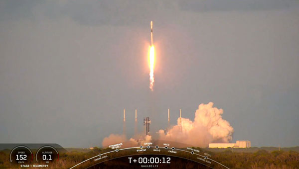
SpaceX has launched the latest pair of Galileo satellites from the Kennedy Space Center in Florida. The SpaceX Falcon 9 rocket carried satellites 31 and 32 (FM26 and FM32) to their designated orbits.
This launch, number 13 in the Galileo program, marks a crucial milestone in the constellation’s development. The addition of these satellites completes the designed constellation, with the required operational satellites plus one spare per orbital plane. The new pair will undergo testing at their final altitude of 23,222 km before becoming operational.
European Space Agency (ESA) Director of Navigation Javier Benedicto highlighted the importance of this launch, stating that the remaining six Galileo First Generation satellites are scheduled for deployment in 2025 and 2026.
These additional satellites are designed to enhance the system’s performance and reliability further, ensuring uninterrupted delivery of highly precise navigation services.
At ION GNSS+ 2024, Eric Châtre, head of EU GNSS exploitation and evolution at the European Commission, and Miguel Manteiga, Galileo project manager at ESA, participated in a panel titled “Status of GPS, Galileo, BDS, QZSS, KPS and NavIC.” They shared how 2024 has been a particularly eventful year for the Galileo program. In April, satellites 29 and 30 were launched and entered service in September. The new Public Regulated Service (PRS) signals began broadcasting, offering encrypted navigation for authorized governmental users. A significant upgrade of Galileo’s ground segment was completed without impacting users.
The Galileo system continues to evolve, with the development of Second Generation (G2) satellites underway. These satellites will feature fully digital navigation payloads, electric propulsion and inter-satellite link capacity.
Mitch Narins’ answer to the question, “If not GNSS, then what?” in the August 2024 issue’s EAB Q&A column, conveys an important message. As a result of their quality and availability, services offered by GNSS create dependencies and subsequently the expectation that of course they must always be there. However, recent experiences have shown we cannot rely on that expectation because either natural or hostile occurrences can disrupt GNSS services, no matter what measures are taken to protect them. That is why the U.S. Department of Defense (DOD), in its “Strategy for the DOD PNT Enterprise,” assessed that, “To combat man-made and natural threats to GPS, other sources of PNT information will be necessary to assure continuous PNT service …”
The strategy describes a layered PNT architecture using global (GPS), regional (eLoran), and local (or self-contained) sources of PNT information. It states, “The global PNT layer is space-based and available worldwide. The regional PNT layer may be implemented in areas … where PNT resiliency must be assured with backup capability. The local layer provides PNT information using man-made and natural information sources available for a limited time or over a limited area.” To achieve resilience from this layered architecture, the strategy provides an integration concept in which GPS and other GNSS are individually integrated with PNT information from the other layers into resilient applications to operate through the hostile environments they will encounter.
Unfortunately, the U.S. government is ignoring a major piece of this layered strategy in favor of space-based and local or self-contained solutions, as it has dismantled virtually the entire legacy Loran infrastructure in the United States and completely in Alaska, although GPS backups are lacking in the Arctic and northern Pacific regions. The loss of the Alaska sites is particularly concerning as the Arctic and northern Pacific Ocean coverage they would provide is a valuable backup to vulnerable GPS signals at a time when other nations are eying the sea lanes north of Alaska/Canada and conducting excursions around the Aleutian Island chain and the Alaskan coast. Coincidentally, the DOD has just published a new “Arctic Strategy,” which requires availability of PNT from GPS (at least) for its success, though “PNT” is not mentioned. However, without effective PNT, whether from GPS or other sources, the systems on which the strategy depends will fail.
As Mitch notes, there are those GNSS advocates who see strengthened GPS/GNSS as the best answer – but real-world events highlight the need for diversification, and now other nations are expanding their Loran-based regional systems. For its Arctic interests and domestic critical infrastructure as well, the U.S. must wake up to reality and do the same.
The European Geostationary Navigation Overlay Service (EGNOS) has released version 3.6 of its Safety of Life (SoL) Service for Aviation Service Definition Document (SDD), introducing several critical updates to enhance EGNOS satellite navigation-based operations.
SDD v3.6 describes improvements in EGNOS architecture for the space and ground segments. For the space segment, the document presents the latest technical information on the geostationary (GEO) satellites that deliver EGNOS services. In the ground segment, the ranging integrity monitoring station (RIMS) network has been expanded to include a new site in Kuusamo, Finland. The addition of this station in the far northern reaches of Europe extends coverage and heightens the robustness of SoL service in this remote and challenging environment.
SDD v3.6 also provides a detailed analysis of the impact of ionospheric activity during Solar Cycle 25, which began in December 2019 and is expected to peak around 2025. This extreme solar activity poses challenges to satellite navigation, and the document offers insights into how EGNOS maintains reliable performance under adverse ionospheric conditions.
The new updates aim to improve the precision, reliability and safety of satellite navigation services in aviation. The SoL service supports various transport domains, primarily focusing on civil aviation, covering localizer performance with vertical guidance (LPV) procedures.
OneWeb Technologies has launched Astra, which is designed to maintain low-Earth orbit (LEO) SATCOM connectivity in GNSS-compromised environments.
The package includes a software-defined outdoor receiver that leverages assured positioning, navigation and timing (A-PNT) broadcast services, significantly enhancing connectivity resilience. Astra can process PNT signals from GNSS and alternative sources across multiple frequency bands to offer continuous connectivity and situational awareness, even in challenging spectrum-contested environments.
The system is compatible with non-GNSS A-PNT broadcast services, such as Iridium. It can identify the optimal PNT source while producing an output signal compatible with the standard GPS L1 interface. In addition to its commercial applications, Astra aligns with the military’s Primary, Alternate, Contingency, Emergency (PACE) communications plan.
Telespazio, a joint venture between Leonardo and Thales, has been selected by the Italian Space Agency (ASI) to lead the creation of the “National GNSS Competence Centre” in Italy. As the primary contractor, Telespazio will head a team composed of Italian universities, research centers, and industrial companies to establish this new center, which will be headquartered at Telespazio’s offices in Rome.
The center’s primary goal is to develop a laboratory network that utilizes resources distributed throughout Italy to advance capabilities, solutions, and technologies in satellite navigation. The project team includes notable institutions such as the National Institute of Metrology Research (INRiM), the Italian Aerospace Research Centre (CIRA), Qascom and the National Inter-University Consortium for Telecommunications (CNIT), along with research units from the University of Pisa, the Polytechnic of Turin, the University of Padua and the University of Roma Tre.
The center will focus on creating new software tools for monitoring GNSS service performance and testing receivers. A cloud-based collaborative platform will be implemented to facilitate shared software development among all project participants. Additionally, the center seeks to expand its network by involving other academic and industrial partners while establishing itself as a national hub for satellite navigation expertise through workshops and training courses.
Telespazio will focus on developing precise, resilient, and robust navigation systems, particularly for emerging technologies such as autonomous vehicles in the aviation, rail, and automotive industries.
Telespazio operates one of two Galileo control centers at its Fucino Space Centre.
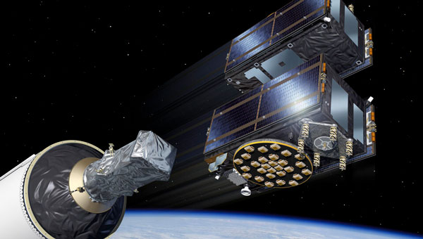
Galileo satellites 29 and 30 have reached their target positions at an altitude of 23,222 km and are now fully operational three months after being launched from Cape Canaveral, Florida, by SpaceX. These new additions to the Galileo constellation are now active and provide navigation signals to users.
Both satellites have been positioned on the same orbital plane, one of three that comprise the Galileo constellation. With this latest addition, two of the three Galileo orbital planes are fully populated, bringing the constellation close to completion. The next Galileo launch is planned in the coming weeks from the Kennedy Space Center in Florida onboard a SpaceX Falcon 9.
The Galileo Service Operator, supported by a team of approximately 30 satellite experts from the European Space Agency (ESA) and satellite manufacturer OHB, conducted early operations at the Galileo Control Centre in Oberpfaffenhofen, Germany, under supervision from the European Union Agency for the Space Programme (EUSPA). Following the initial operations, the satellites entered a drift phase, during which ground teams guided them to their final positions, which was reached on June 24.
On August 21, 2024, ESA, OHB and payload manufacturer SSTL evaluated the in-orbit test results, confirming that the satellites had not experienced any degradation during launch. ESA, in collaboration with EUSPA, then validated the satellites’ performance at the system level.
GNSS researchers presented hundreds of papers at the 2023 Institute of Navigation (ION) GNSS+ conference, which took place Sept. 11-15, 2023, in Denver, Colo., and virtually.
The following four papers focused on ways to combat GNSS jamming and spoofing. The papers are available here.
GPS World will attend this year’s ION conference in Baltimore, Maryland on Sept. 16-20.
Approximating Regional GNSS Interference Sources Using ADS-B Data
The Automatic Dependent Surveillance-Broadcast (ADS-B) system, widely used for air traffic operations and management, also has potential applications in identifying, detecting and localizing (IDL) GNSS/RFI jamming sources in regions with high air traffic. With the rise in global GNSS interference reports, it is crucial to identify and eliminate jammers to ensure safe air travel operations.
The Navigational Integrity Category (NIC) value included in the ADS-B message is a key indicator for detecting potential jamming from ADS-B data. Although NIC is not the most effective metric for interference detection, it can still signal the presence of jamming and offer a means to localize the source in real time.
This research aims to approximate the area of GNSS/RFI interference by fitting a Euclidean Cone to ADS-B data that reports low NIC values. The problem is formulated as a convex optimization problem, derived from an alternative version of the maximum inscribed ellipsoid approach. By fitting an optimal cone to the data affected by interference, the cone’s apex indicates the estimated jamming location. The research team processed, decoded, interpolated and filtered ADS-B data to enhance localization accuracy.
The proposed convex formulation was tested on two reported interference events: one near Denver International Airport in January 2022, for 36 hours, and another near the Dallas-Fort Worth area in October 2022, over roughly eight hours. In Denver, four estimated jamming locations, calculated from four six-hour time windows, were grouped between downtown Denver and the airport. In Dallas, three estimated jamming locations, determined from three one-hour windows, showed a tighter grouping on the southern side of the Dallas/Fort Worth area, indicating spoofing was nearby.
Michael Dacus, Zixi Liu, Sherman Lo and Todd Walter, “Approximating Regional GNSS Interference Sources as a Convex Optimization Problem Using ADS-B Data.”
Hybrid Autoencoder for Interference Detection
Malfunctions or failures in GNSS services can result in significant personal, material, and financial damages. Early identification of anomalous behavior in GNSS signals can enable timely countermeasures. However, many interference monitoring or mitigation techniques are only feasible with high-end receivers and demand a certain level of expertise to be used effectively.
This paper presents a GNSS interference monitoring approach employing machine learning methodologies for users of any expertise level and with any type of GNSS receiver capable of outputting raw GNSS observations. The research team used simple signal-to-noise ratio (SNR) observations and different hybrid autoencoder models, including denoising or variational autoencoder combined with recurrent neural network (RNN) models, which are trained and tested on real jamming and spoofing events. The developed monitoring system is represented by a “traffic lights” system, indicating the severity or level of concern associated with each detected anomaly.
The results compare different RNN-based autoencoder implementations and have been tested on input data from high-end to low-end GNSS receivers. The analysis of the test set showed that there is a 95 percent probability of catching anomalies. Additionally, similar results were achieved when applied to other geodetic receiver types such as u-blox or JAVAD GNSS receivers. However, smartphone data is subject to some limitations. Notably, missed anomalies are primarily attributed to the low transmitting power from the jamming and spoofing devices, which poses challenges for detection.
Karin Mascher, Stefan Laller and Philipp Berglez, “Hybrid Autoencoder for Interference Detection in Raw GNSS Observations.”
A Tool to Monitor, Analyze and Record Navigation Signals
Given the heavy reliance on GNSS for numerous critical applications, any disruption caused by intentional or unintentional RFI could pose significant threats to operations that depend on these systems, from transportation and logistics to emergency services and national security. Developing advanced countermeasures against RFI has become a priority to ensure the functionality and resilience of GNSS-dependent systems.
This paper presents an architecture for real-time detection and classification of RFI affecting multi-band GNSS signals based on a machine learning method. The study proposes an architecture combining an actual GNSS monitoring station for recording GNSS signals — a Navigation Signals Monitoring, Analysis, and Recording Tool (N-SMART) system — with a deep neural network approach to detect and classify different classes of interferences.
Researchers propose a novel architecture for real-time interference detection and classification of RFI, which can continuously monitor and record multi-band GNSS signals and provide timely warnings in case of RFI. The proposed architecture utilizes the N-SMART system to capture and store the GNSS signals, while detection and classification are implemented using a deep neural network technique. The core principle of the suggested method is to implement a convolutional neural network (CNN) classifier inside a Docker container, running on top of the N-SMART system.
The results of the experimental test campaign on real interfered GNSS signals showed an overall accuracy of 85 percent, demonstrating the potential for effective, real-time classification of RFIs in GNSS. The research team explains that future work could focus on optimizing the model or exploring new architectures of CNN to improve accuracy and reduce task completion time across a variety of applications.
Iman Ebrahimi Mehr, Alex Minetto and Fabio Dovis, “A Navigation Signals Monitoring, Analysis and Recording Tool: Application to Real-Time Interference Detection and Classification.”
GNSS RFI Mitigation in Commercial Airborne Receivers
Reports from air navigation service providers worldwide indicate that commercial airborne GNSS receivers are increasingly being subjected to jamming and spoofing attacks. Consequently, there is a growing need to ensure that the raw GNSS measurements provided to aircraft systems are not compromised by spoofing. Validating these measurements is critical to maintaining the integrity and reliability of navigation systems used in aviation.
This paper focuses on two techniques under development by Collins Aerospace to be incorporated via a field-loadable software update to the Collins GLU-2100 multi-mode receiver to combat spoofing attacks. The first method, Receiver Autonomous Signal Authentication (RASA), uses the known characteristics of the GNSS receiver oscillator to detect whether the received signals are from a spoofer.
A second technique, Staggered Examination of Non-Trusted Receiver Information (SENTRI), uses the inertial sensor data already available from the aircraft’s IRS/INS, to monitor the coherence between pure GNSS, pure inertial (INS) navigation solutions or tightly coupled inertial GNSS hybrid solutions without augmentation. SENTRI further allows the computation of position integrity levels (HPL and VPL) in the presence of GNSS spoofers. The paper will describe the overall RFI mitigation architecture that is implemented on the GLU-2100.
RASA and SENTRI can be used together in a complementary fashion to detect the presence of spoofers reliably. It will also provide improved robustness to data spoofing attacks that induce errors in ephemeris, almanacs, GPS time jumps, etc., and will enable the GLU-2100 to coast through GNSS outages that are induced due to spoofing or jamming.
Future technologies will use antenna techniques, signal analysis, DFMC signals and APNT to increase the robustness to new and evolving threats. The goal of this RFI mitigation roadmap is to continue to ensure that GNSS can be used safely and reliably in civil aviation.
Angelo Joseph, Joseph Griggs, Patrick Bartolone, Bernard Schnaufer, Huan Phan, Vikram Malhotra, “GNSS Radio Frequency Interference Mitigation in Collins Commercial Airborne Receivers.”
Locus Lock has partnered with Xona Space Systems to develop a GNSS receiver that uses Xona’s multi-frequency PULSAR service. Locus Lock aims to provide a robust software-defined GNSS receiver for commercial and military applications.
According to the company, Xona’s PULSAR service will be delivered via a constellation of low-Earth orbit (LEO) satellites, which orbit the Earth approximately 20 times closer than traditional GNSS satellites. This proximity allows PULSAR to offer higher signal power and a modernized signal design to offer improved multipath mitigation, higher accuracy and increased protection against radio frequency interference and spoofing compared to current GNSS systems.
The technology is suitable for various applications, including vehicles navigating dense urban areas, agriculture and construction, UAVs, high-speed aircraft and defense applications. Locus Lock’s GNSS software stack can be deployed on existing customer computational infrastructure, ranging from small embedded devices to larger centralized computers. This flexibility allows for adaptation and configuration of the software to suit specific deployed environments.
The system features inertially aided carrier-phase differential GNSS (CDGNSS) for maintaining precision in challenging ecosystems, advanced interference mitigation and detection technology to ensure authentic GNSS signals are received, and the dual-antenna, triple-frequency RadioLion RF front-end for capturing raw GNSS signals. These features offer signal situational awareness, anti-spoofing, and interference mitigation.
China’s BeiDou high-precision navigation and positioning service platform has entered trial operation, The National Geomatics Center of China reported.
Developed under the leadership of the Ministry of Natural Resources, the platform integrates satellite navigation and positioning base stations nationwide within the natural resources system. This initiative consolidates more than 3,300 base stations into a unified network, offering centralized management of station resources.
The network offers seamless, high-precision positioning services nationwide, delivering real-time, accurate and reliable navigation for sectors including public welfare mapping, resource surveying, intelligent transportation, autonomous driving, precision agriculture and social governance.
The service is available both online and offline. Online, it offers real-time observation data and enhanced positioning services. Offline, the platform delivers coordinate results, post-event observation data files, and related products.
The BeiDou Navigation Satellite System (BDS) was initiated in 1994. The construction of BDS-1 and BDS-2 was completed in 2000 and 2012. When BDS-3 was completed and put into service on July 31, 2020, China became the third country to have an independent global navigation satellite system.
The European Union Agency for the Space Programme (EUSPA) has completed the testing of the Galileo Open Service Navigation Message Authentication (OSNMA) and is now gearing up for its operational launch.
Galileo, similar to any other GNSS, is used by many critical applications in transportation, finance, telecommunications, information technology, energy, utilities, manufacturing, health services, emergency services and law enforcement.
However, the rise in spoofing attacks, which can disrupt these services, has prompted the development of OSNMA. This capability, integrated into the Galileo infrastructure by EUSPA, the European Commission (EC), and the European Space Agency (ESA), aims to enhance the security of GNSS signals.
The OSNMA Public Observation phase began in November 2021, supported by the release of the Signal in Space Interface Control Document (SIS ICD) and the Receiver Guidelines, which facilitated early testing of OSNMA receivers worldwide. Since then, users have reported that the OSNMA signal has been transmitted by Galileo satellites with high stability and performance.
In December 2022, EUSPA and the EC published the OSNMA SIS ICD and Receiver Guidelines for the service phase, with further updates released between October 2023 and January 2024. Additionally, the OSNMA Internet Data Distribution (IDD) ICD was published in July 2023 and updated in January 2024, alongside the operational cryptographic material. The OSNMA signal has been transmitted following these specifications since August 2023.
According to EUSPA, Testing activities by industry and public actors have confirmed the readiness of the service, with the latest cryptographic material published by EUSPA in January 2024. This material and necessary certificates are available through the EUSPA and GSC websites for the Initial Service provision phase.
The testing activities concluded in early June 2024 with the execution of cryptographic keychain renewal and revocation processes. The program is now preparing for the OSNMA Initial Service declaration, which will include an EC communication, the publication of the OSNMA Service Definition Document (SDD) and the transition of the OSNMA Status Flag from “test” to “operational” following a process similar to that used in 2023 for the Galileo High Accuracy Service (HAS) Declaration. According to EUSPA, a dedicated Galileo Service Notice will soon be published to announce the conclusion of the testing activities of the Public Observation Phase.
UAVOS has collaborated with a client to conduct extensive testing of UAVOS’ autopilot system, which utilizes computer vision technology. UAVOS’ engineering service supported this testing with its advanced avionics system integrated into its unmanned helicopter.
The UAVOS autopilot system uses computer vision and artificial intelligence (AI) to navigate the UAV in GNSS-denied environments with precision and reliability.
The system’s onboard computer vision-based alternative navigation module, powered by deep learning algorithms, provides the UAVOS avionics system with accurate geospatial coordinates. This innovative approach allows for seamless navigation in both daylight and nighttime conditions, ensuring safe take-off and landing procedures without relying on external GNSS signals. By enabling the drone to effectively “see” and interpret its surroundings, UAVOS has created a solution that grants UAVs unprecedented autonomy and operational flexibility.
TrustPoint has secured two Direct-to-Phase II contracts from SpaceWERX, totaling $3.8 million, to advance its GPS-independent ground control segment and develop an advanced positioning, navigation, and timing (PNT) security application. The application is designed to address critical challenges within the Department of the Air Force (DAF) and strengthen the United States’ national defense.
The Air Force Research Laboratory (AFRL) and SpaceWERX, the innovation arm of the U.S. Space Force and a division within AFWERX, have partnered to streamline the Small Business Innovation Research (SBIR) and Small Business Technology Transfer (STTR) processes. Their efforts focus on accelerating proposal-to-award timelines, expanding opportunities for small businesses and reducing bureaucratic overhead through continuous process improvements.
In 2018, the DAF introduced the Open Topic SBIR/STTR program to broaden its funds’ range of innovations. This initiative has paved the way for companies like TrustPoint to develop innovative capabilities contributing to national defense.
TrustPoint is developing a commercial GPS service using a C-Band low-earth orbit (LEO) satellite constellation. The system is designed to offer the high performance, security and availability required for autonomous navigation, critical infrastructure and national security.