Austria is breaking new ground in space. BeaconSat is the largest satellite ever developed in Austria and also the country’s first military satellite. The project is being led by Austrian start-up GATE Space, based in Schwechat. Launch is planned for February 2027 aboard a SpaceX Falcon 9 rocket.
BeaconSat is designed to detect and analyze jamming and spoofing attacks on GNSS — targeted attempts to interfere with and manipulate navigation signals such as GPS or Galileo. Austria is responding to a security policy development that has real implications for aviation, transport, energy supply, and military operations.
Attacks on critical infrastructure
Jamming and spoofing incidents are frequent in geopolitically tense regions. In aviation, repeated disruptions have affected civilian aircraft.
“Space is now a central component of Europe’s and Austria’s security and defense strategy,” said Major General Friedrich Teichmann, head of the ICT and Cybersecurity Center. Navigation signals have long been part of critical infrastructure, and securing them is therefore of great strategic importance.
However, many of these attacks remain invisible. Countries often do not know where the interference is coming from, how systematic it is, or what pattern lies behind it. This is where BeaconSat comes in.
Technology demonstrator with strategic dimension
BeaconSat will systematically detect and analyze GNSS interference signals from orbit for the first time. The aim is to obtain data on when and where navigation systems are being deliberately disrupted. The mission is designed as a multi-year research and development project.
“It is important that we are able to act independently in terms of communication and navigation when necessary. This is a question of resilience and military capabilities,” emphasized Defense Minister Klaudia Tanner. “Space is an essential part of military capability.”
The satellite is not intended to be an isolated military project, but rather a demonstrator. Civil space technologies are being further developed for security-related applications and tested under real-world conditions. The findings will be incorporated into the operational processes of the Federal Ministry of Defense (BMVL).
Austrian industry at the center
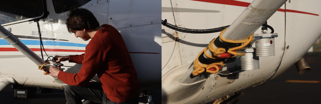
GATE Space has overall responsibility for the project. Founded in 2022, the spin-off from TU Wien develops chemical propulsion systems for satellites and currently employs around 27 people. For BeaconSat, the company is supplying the propulsion system, the satellite structure, and the thermal management system, among other things.
“With BeaconSat, we are making a direct contribution to Europe’s security. The market for such capabilities is huge,” said Managing Director Moritz Novak.
The engines were tested in more than 8,000 hot runs at the site near Vienna Airport, both under atmospheric conditions and in one of Europe’s most powerful vacuum chambers.
GATE Space was supported by the Federal Ministry for Innovation, Mobility, and Infrastructure (BMIMI) through Austria Wirtschaftsservice (aws) with funding of around 750,000 euros.
Jamming and spoofing detection
A central contribution to the payload comes from the Graz-based company IGASPIN, which develops systems for the precise detection and analysis of GNSS interference. Additional components, including the on-board computer, are supplied by the Danish company Space Inventor.
At the European level, the mission is supported and co-financed as a technology demonstration via the European Space Agency’s ESA Marketplace. Off-the-shelf systems are specifically used to test commercially available technologies under security-relevant conditions.
New space chapter in the Ministry of Defense
BeaconSat also marks a turning point institutionally. The BMLV is currently setting up its own organizational unit for space services. The focus is on three areas: satellite communication, satellite navigation, and satellite-based reconnaissance.
“These space services are key to cross-domain operations and make a substantial contribution to the Austrian Armed Forces’ modern reconnaissance, command, and control network,” Teichmann said.
BeaconSat will provide data that will be directly integrated into military decision-making processes. At the same time, the project contributes to European resilience: those who recognize threats early on can respond diplomatically, politically, or technically.
Space as a growth area
The strategic importance of space technologies is growing both in terms of security policy and economics. Austria has recently increased its contribution to the ESA from 260 to 340 million despite budgetary constraints. Space and aviation technologies are anchored in the government’s industrial strategy as one of nine key technology fields.
Satellites have long been considered critical infrastructure. They enable navigation, communication, Earth observation, climate monitoring, and security applications. At the same time, new markets are emerging in the areas of propulsion systems, data analysis, and dual-use technologies.
With BeaconSat, Austria is repositioning itself in terms of security policy and industry. The project is an example of how startups, established technology companies, ministries, and European partners can and must work together successfully.
With full multi-constellation, multi-frequency GNSS signal protection, the GAJT-AE3 provides assured positioning, navigation and timing (PNT)
Hexagon | NovAtel has launched the latest addition to its battle-proven GNSS Anti-jam Antenna Technology (GAJT) lineup: GAJT-AE3. The GAJT-AE3 emerges in response to the escalating power and sophistication of jamming techniques that disrupt satellite-based navigation systems, a concern highlighted by current worldwide geopolitical conflicts.
As jammers become more powerful and low cost, with the capability of targeting a wider range of GNSS frequencies, there is a critical need for next-generation functionality and reliability.
To address this, the GAJT-AE3 protects all major GNSS constellations with full multi-constellation, multi-frequency coverage. This significant advancement in jamming protection — in a compact format — ensures reliable PNT in demanding airborne environments.
“This is a revolutionary expansion in our battle-proven anti-jam solutions designed specifically for space-constrained platforms,” said Stig Pedersen, president, Aerospace & Defence Division, Hexagon. “The GAJT-AE3 offers unparalleled signal coverage and multi-jammer direction finding for superior protection and heightened situational awareness.”
The GAJT-AE3’s antenna electronics mitigate interference by creating up to seven nulls per band in the direction of jammers, providing significant anti-jam protection even in dynamic multi-jammer scenarios. The output is a protected radio frequency signal, free from jamming and suitable for input to modern and legacy GNSS receivers.
Protecting and supporting all GNSS frequencies, including L-band corrections and Iridium PNT, the GAJT-AE3 is an easy-to-integrate, compact unit suitable for use on a variety of platforms, from UAVs to complex weapons. It can be paired with a range of antennas from the Hexagon | Antcom portfolio, including custom options.
Hexagon | NovAtel’s GAJT-AE3 is now commercially available.
We just finished the year that marked the 30th anniversary of America’s Global Positioning System (GPS) reaching full operational capacity. What began as a military tool to enable U.S. military forces to navigate more precisely and to support the use of precision strike weapons anywhere in the world has become the invisible infrastructure that powers nearly every aspect of civilian life. So much of our everyday lives, from smartphones and ATMs to aviation, shipping and Wall Street, run on precise timing and location information.
However, that infrastructure is now under duress. Our adversaries are waging a sophisticated war on GPS signals, and the fallout is both significant and frightening. Reports of navigational issues across the Baltic and the Middle East have become a daily occurrence due to conflicts in the region. The impacts have extended into civilian life, impacting air, land and sea.
It’s a miracle the regions have avoided a major aviation disaster, given that navigational warfare and space have become new domains of nation-state confrontation. Russia is spoofing and jamming signals across Eastern Europe. Russia and China are also shadowing military and civilian satellites, performing dangerous dogfighting maneuvers in orbit.
Jamming and spoofing were once rare. Now, they are battle-tested tools in the electronic warfare arsenal, and the U.S. is not immune to their effects. What’s happening in these regions today could happen over Chicago or Atlanta tomorrow.
Similar interference has been detected near major U.S. airports, including Dallas and Denver, impacting nearly 350 flights. Nation-states were not responsible for these incidents, but they prove how vulnerable GPS is to disruption.
This isn’t a Hollywood thriller. A coordinated attack on GPS would ripple across aviation, finance, emergency response, and daily life within minutes, not days. We’ve already seen how quickly systems collapse when digital links are severed.
In 2022, a volcanic eruption in Tonga severed the country’s only undersea cable and blocked satellite signals, plunging the island into an instant blackout. Commerce broke down, and government emergency coordination collapsed. ATMs couldn’t dispense cash because banks couldn’t confirm account balances. Cargo planes couldn’t file manifests, and supply chains froze. Farms and fisheries couldn’t complete online forms, so produce rotted. Pharmacies couldn’t fill prescriptions because their supply systems were offline. The effects were immediate and took months to normalize.
If GPS goes down, whether because of jamming, spoofing, a cyberattack or a natural disaster America is dangerously unprepared. Our widespread reliance on a vulnerable technology should be a wake-up call. A single sustained outage could cost the U.S. economy an estimated $1.6 billion per day.
When I served as commander of U.S. Cyber Command, our team was responsible for ensuring the networks underpinning our military missions were fully operational and secure, and as the director of the National Security Agency, the team was focused on generating deep knowledge of threats to the U.S. and allied operations across land, sea, air, space and cyberspace. In both roles, it became very clear that we needed to protect our positioning, navigation and timing infrastructure, and that one of the keys to doing so was to create layered resilience.
Solving a problem of this magnitude is a massive challenge. But we don’t need to start from scratch. By leveraging existing infrastructure in space and on the ground, we can accelerate deployment, reduce cost and avoid duplication. Speed and scale are essential. It’s not a question of whether the U.S. experiences a major GPS disruption, but when.
Fortunately, the technology already exists. American companies are developing methods to provide positioning, navigation and timing backup via terrestrial 5G networks, offering timing and location signals that are independent of satellites. These solutions are scalable, cost-effective and designed to integrate directly into existing telecom infrastructure such as cell towers. If commercial providers are already exploring complementary backup technologies, why are we still lagging behind our adversaries?
The real barrier isn’t technology — it’s policy. Moving the process forward to make these technical capabilities a reality is the challenge. Getting government bureaucracies to act with urgency is never easy, but the administration and Congress now recognize the stakes.
The Federal Communications Commission has launched an inquiry into strengthening national positioning, navigation and timing infrastructure, including exploring ground-based alternatives such as 5G-powered systems. Now it’s time to follow through and move from planning to execution.
The threats are real; the technology is ready; and the cost of inaction grows by the day. Replacing GPS is not a realistic near-term solution, either in terms of cost or the time frame required to do so. Our focus should be on building a layered, resilient system that provides users with multiple options to react to loss or degradation of our current positioning, navigation and timing structure. One layer of that system should be a ground-based component that takes advantage of the existing infrastructure already in place, saving us significant time and money in creating a solution to this critical problem.
Several interesting things, according to geologists who study data from the global network of geodetic-quality receivers. A team at the University of the Basque Country found the Iberian Peninsula rotating clockwise as Africa closes on Eurasia by 0.2 inches per year (5 mm), near Gibraltar and the Alboran region. Meanwhile, in a process called lithospheric dripping, Earth’s crust is sinking under Central Turkey despite being part of a broader region that has been uplifting for millions of years, according to University of Toronto researchers. Meanwhile, in the U.S. Pacific Northwest, seismic data collected during a National Science Foundation study shows the Cascadia subduction zone actively breaking apart.
Making better robots with GNSS
Image: Robosat Project
Autonomous robot navigation in the wild using satellite-based 3D geographical information (Robosat) aims to provide a scalable multi-GIS high-quality data collection platform through using a quadrupedal robot that can autonomously perform long-distance missions in challenging environments, such as the Alps or Finnish forests. Researchers from Finland, Switzerland, Spain and Romania gathered at Tampere University in Finland to share data, identify relevant GIS and GNSS datasets, and leverage AI for autonomous labeling of large-scale data. Key topics included integrating multi-sensor and multi-GIS data to enhance positioning, planning pilot tests with ETH’s ANYmal robot (pictured) and TAU’s new I/Q GNSS grabber device, and discussing methods for AI-driven data labeling for massive datasets collected in field trials.
It’s all happening downtown
Image: Getty Images / Ivan Pantic
Researchers from Shandong Jianzhu University and the China University of Mining and Technology describe a new smartphone positioning strategy in the Dec. 15, 2025, issue of Satellite Navigation. They use a positioning framework that combines 3D map constraints with multiple GNSS observations. By integrating time-differenced carrier-phase information with probabilistic road matching and factor graph optimization, the approach reduces ambiguity in candidate positions and enhances robustness against non-line-of-sight signals. In field tests, the method outperformed existing smartphone GNSS techniques, delivering more reliable location estimates and smoother trajectories even in severe urban canyon conditions.
2,000 and counting
Image: Getty Images / rvimages
The International Air Transport Association (IATA) has called for vigilance following the increasing number of GNSS spoofing and jamming incidents worldwide. The growing interference poses a significant risk to flight navigation and pilot safety. Of note is a spike in incidents at major Indian airports. Almost 2,000 GNSS interference incidents have been logged at airports in India since 2023, including the airports in Delhi, Mumbai, Kolkata, Amritsar, Hyderabad, Bengaluru and Chennai. IATA represents more than 360 airlines, accounting for 80% of global air traffic.
Dimetor is providing its NAVSentry airspace situational awareness system to the World Economic Forum annual meeting, in support of the Austrian Armed Forces. The meeting is taking place this week in Davos, Switzerland, close to the Austrian border.
NAVSentry is an AI-powered platform for detecting GNSS disruptions in real time, combining different technology layers and securing position, navigation and timing (PNT) data across autonomous and crewed systems from multiple data sources.
The system is providing insights into the integrity of GNSS signals to strengthen the Austrian Armed Forces’ ability to monitor, secure and protect the airspace against threats, including including jamming and spoofing attempts targeting the airspace and critical PNT infrastructure.
The enhanced situational awareness strengthens the ability to detect anomalies, assess potential threats, and coordinate protective measures across both the physical and cyber domains.
“It’s a compelling example of how modern defense increasingly also builds on trusted civilian–military technology partnerships to safeguard critical events,” said Brigadier-General Friedrich Teichmann, commander, Space Services, Austrian Armed Forces.
infiniDome has introduced Aura, a new GNSS protection system built for platforms that cannot afford to lose their way. According to the company, this development comes at a time when GNSS interference incidents have surged by more than 400% across Europe and the Middle East over the past two years, making uninterrupted navigation a strategic necessity.
Developed from years of field-proven operational experience, Aura is designed to redefine navigation resilience with smarter algorithms, faster interference response and a compact, rugged design capable of operating in contested environments.
The system is available in two configurations: Aura, the enclosed version for rapid deployment, and AuraCore, the OEM module for integration. The system brings mission-grade protection to platforms ranging from small UAVs to large autonomous vehicles.
Among several new capabilities, Aura features enhanced null-depth performance, enabling the system to withstand higher jamming power, and a new saving power mode that dynamically reduces energy consumption when no interference is present.
“Aura isn’t just an upgrade; it’s a new philosophy,” said Omer Sharar, CEO of infiniDome. “It takes everything we’ve learned from real-world interference events and transforms it into a smarter, faster and more adaptive layer of defense. With Aura, we’re not just protecting GPS; we’re protecting autonomy itself.”
Engineered for modern battlefields and complex environments, Aura introduces a new level of performance and resilience.
Its adaptive algorithms ensure reliable navigation under evolving jamming conditions, while the optimized C-SWaP design keeps the system lightweight, low-power and mission-ready.
Capable of mitigating interference from up to three directions per frequency simultaneously, Aura delivers protection that is powerful and efficient, tested and validated in live high-power jamming environments across multiple regions.
These results position Aura as one of the most advanced and field-proven GNSS protection systems available.
With Aura, infiniDome said it continues to advance its vision of navigation resiliency, ensuring that operators stay connected, coordinated and in control, even under severe electronic attack.
Aura is available for early access evaluation and OEM integration, with full release scheduled for early 2026.
Position, navigation and timing (PNT) services, derived primarily from GNSS constellations, have become a critical element underpinning the global economy, with a vast range of sectors depending on these signals.
This includes coordinating financial transactions, stabilizing power grids as well as navigation, with supply chains set to become more reliant on the technology as autonomous vehicles become prevalent. However, GNSS is a vulnerable technology, with faint signals from medium-Earth orbit (MEO) satellites being susceptible to disruption.
In this article we’ll look at how both static and dynamic applications can achieve resilient PNT, with strategies and sensor fusion techniques that allow operational capability when GNSS is denied.
Seven hundred. That’s the number of GPS interference events such as jamming and spoofing that take place every single day, according to the U.S. government. And this number is increasing across North America and Western Europe, with it being especially prevalent in or near war zones.
Indeed, in August, the navigation system of a plane carrying the EU President, Ursula von de Leyen, was reportedly targeted by a GPS jamming attack as it was due to land in Bulgaria — forcing pilots to rely on paper maps. And GPS interference has been linked to the crash of Azerbaijan Airlines flight J2-8243, which was shot down on Christmas Day, 2024.
Relying on a single source for PNT is no longer a viable strategy and developing a resilient PNT ecosystem that can function in D3SOE (denied, degraded, and disrupted space operational environments) has become essential.
While navigation is the most commonly understood application of PNT, the timing component is critical in so many of the static systems we rely on — not just finance and power (as listed above) but for AI data centers, asset tracking systems and communication networks — which require precise and stable time references to ensure data integrity, and need these to be synchronized across global networks.
For such systems, the consequences of getting timing off by even the smallest amount can be seen in the 2016 decommissioning of the SVN23 GPS satellite. During this, a software error created a 13.7 microsecond anomaly across the entire constellation that, according to a UK government report caused issues with digital radio broadcasts and communication networks. The event is also seen by some as a warning for the financial sector and in particular for high-frequency trading (HFT), where trades take place in millionths and studies have suggested that a 1 ms advantage in trading applications could be worth $100 million a year to a major brokerage firm.
By subtly altering timing signals used by trading systems, malicious actors can effectively see and use market data “from the future” and enact transfers worth billions of dollars.
Similarly, a timing attack on the phasor measurement units (PMUs) used to measure real-time stress in power grids could trigger major blackouts. The effect of such an attack can be seen in 2003’s (pre-PMU) Northeast Blackout, in which a sagging power line touched tree and caused a series of cascading outages that affected 55 million people across the U.S. and Canada.
And further putting the importance of protecting PNT in context, in 2020 the U.S. defined 16 critical infrastructure sectors as part of its Executive Order 13905. Of these 14 (88%) of these are reliant on PNT for their safe operation. Going beyond the energy and finance examples above, this includes sectors like communications, transportation, and agriculture. In short, PNT resilience is essential across virtually the entire economy.
Detecting a Compromised GNSS Signal
Of course, the first stage in protecting a PNT signal is in the identification of an attack, and several techniques can be used to identify inconsistencies that point to jamming or spoofing.
These range from the analysis of the signal’s Doppler shift (transmissions from nearby terrestrial spoofer will have a near-zero Doppler shift) to techniques like RAIM (receiver autonomous integrity monitoring), which continually recalculates position while excluding one satellite each time to see if the results are consistent.
Cryptographic methods, such as Galileo’s Open Service Navigation Message Authentication (OSNMA), are also available to verify a satellite’s digital signature and confirm the data’s authenticity.
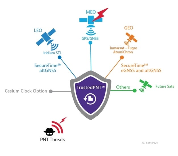
However, relying on cryptographic authentication alone still comes with risks. Notably, authenticated signals are susceptible to meaconing attacks, where a legitimate signal is recorded and replayed later to mislead a receiver. It is, however, possible to counter these attacks using a secure, out-of-band verification layer for all GNSS constellations. This involves the independent delivery of authentication data with hash authentication transmitted via encrypted L-band correction signals from geostationary (GEO) satellites.
This approach can also be retrofitted to older equipment using PNT by using an RSR transcoding device (see below).
For dynamic systems, an additional level of validation can be gained by inertial sensors, comparing their output against PNT data to detect both sudden large jumps in position and continual slight deviations that can be characteristic of a sophisticated spoofing attack.
Timing in Static Applications
The timing architecture of such systems must go beyond simply identifying a threat and validate incoming data. This requires the integration of alternative PNT sources through an intelligent sensor fusion framework. To achieve this level of resilience in a fixed location, a multi-source, zero-trust approach is necessary. This involves augmenting or replacing GNSS with a layered defense of terrestrial and alternative space-based signals that can be authenticated and trusted.
Modern PTP grandmasters utilize the latest sub-microsecond accuracy Precision Time Protocol (PTP) and the more common millisecond-range Network Time Protocol (NTP) to ensure compatibility with nearly all standard IT equipment.
High-speed 25G PTP Ethernet connections are also being implemented to support high-performance AI data centers and financial exchanges without creating data bottlenecks. To ensure continuous operation during extended GNSS outages, these systems can draw synchronization from terrestrial sources like a network PTP feed or an optional atomic caesium clock.
Furthermore, it is also possible to use encrypted L-Band signals from geostationary (GEO) satellites, such as those from Inmarsat, which create an enhanced timing service with built-in GNSS authentication and anti-spoofing features to deliver timing accuracy of sub-5 ns.
Figure 1: VIAVI’s Inertial Labs division has developed a Visual-Inertial Navigation System (VINS) that combines 3D vision aided mapping with inertial accelerometers to enable positioning in D3SOE environments — shown in prototyping stage.
Navigation Without a North Star
While static applications can utilize fixed terrestrial infrastructure for backup, dynamic systems do not have this luxury.
The inherent weakness of RF signals makes them easy to overpower through deliberate jamming by hostile actors. As such, navigation systems onboard UAVs and autonomous vehicles, as well as manned commercial and military vehicles require self-contained navigation capabilities that can function reliably when GNSS signals are compromised. This has driven significant advances in inertial navigation.
Sensors like accelerometers and gyroscopes have become a critical source for orientation and direction data that remains available at all times. The development of micro-electromechanical systems (MEMS) has been crucial, enabling the integration of inertial navigation into even the smallest systems.
These sensors aren’t an alternative to PNT satellites. By their very nature they will accumulate errors over time, with sensor bias causing drift and random-walk deviations allowing random noise in each measurement to accumulate. However, recent years have seen significant gains in their accuracy, allowing navigation to continue for short periods after GNSS data is compromised.
Combining these inertial sensors with sensor fusion techniques also allows each element in a multi sensor system (using magnetometer; and accelerometers/ gyroscopes for roll, pitch and yaw…) to be continually verified by the others for further improvements in accuracy, reducing overall level of error. Data from these IMUs can also be fused with signals from alternative satellite constellations like those in LEO.
LEO satellite signals are less accurate for timing than GNSS (around 80 ns vs. sub-15 ns) but are significantly stronger. For example, the Iridium LEO STL signal is c.1,000 times stronger than GNSS, making these signals both more resistant to jamming and harder to undertake a (successful) denial of service.
More recently, techniques using downward-facing camera to track fixed identifiable landmarks have been developed as an alternative / additional data validation method for dynamic systems.
These external sources provide absolute reference points that can be used to correct the inertial system’s calculations, dramatically improving accuracy and enabling reliable navigation for much longer periods.
Figure 2: VIAVI’s SecureTime uses GEO and LEO constellations to provide positioning and timing signals that are resilient to attacks.
Sensor Fusion Gives Resilience
The limitations of individual PNT sources — whether the vulnerability of GNSS or the inherent drift of inertial sensors — mean they cannot depend on a single technology. The most effective strategy is often a hybrid one, combining a high-accuracy inertial sensor unit with inputs from other sensors.
As we touched on above, adding data sources improves the ability to detect and counter PNT attacks. For example, the EU has confirmed it will deploy additional LEO satellites to bolster its ability to detect GPS interference. And vision cameras can also be used as part of a Visual-Aided Inertial Navigation System (VINS), which provides a powerful method for maintaining an accurate position in the complete absence of GNSS signals.
This technique was developed in 2025 by VIAVI’s Inertial Labs division, with VINS combining processing with multiple inertial sensors to maintain position. This is reinforced with, and calibrated by a 3D vision-based positioning algorithm that compares visual patterns captured by an onboard camera (either daylight or infrared) with pre-loaded, satellite-imagery-derived 3D maps to track against known landmarks. In a GNSS-denied environment, a VINS system can maintain a horizontal position within 35 m, a vertical position within 5 m, and a desired velocity within 0.9 m/s.
Conclusion: Bridging the Legacy Gap
While modern systems can be designed from the ground up with a multi-layered, sensor-fusion PNT architecture, there is still the problem of the huge number of legacy systems that are very much prone to attack.
These legacy PNT systems are still widely used, including in military conflicts where D3SOE attacks are prevalent. To address this vulnerability, resilient signal retransmission technology has been developed to cost-effectively upgrade these older systems. This approach uses RSR transcoders (constellation simulators) to take a trusted PNT signal, derived from multiple assured inputs, and convert it into the standard GPS format that legacy equipment is designed to receive. This set up – in which the GNSS aerial is replaced with the input from the RSR transcoder – allows the existing systems to operate with state-of-the-art resilience without requiring replacement.
But, as we’ve seen in the above, a single, invulnerable replacement for GPS is simply not possible, so integrating multiple trusted sources is therefore essential. The path to assured PNT relies on a multi-layered ecosystem of diverse signals and sensors and applying this approach to both modern designs and legacy-system upgrades ensures all assets can maintain uninterrupted PNT access.
The demand for efficient transportation systems extends beyond traditional development projects, such as subsea transportation tunnels or deployment scenarios where positioning technology delivers centimeter-level accuracy for fleet vehicles. In active conflict zones, positioning signals are more susceptible to jamming and spoofing, which disrupts civilians’ daily activities.
In the northern Israeli city of Haifa, after decades of relying on digital navigation, shopkeepers have started stocking paper maps again. The reason is not nostalgia, but survival in an age of electronic warfare.
The coastal city has become a testing ground for advanced GNSS technologies, where traditional satellite navigation systems regularly fail due to sophisticated spoofing attacks. These attacks not only disrupt military operations but also affect every smartphone, smartwatch and navigation device that relies on standard GPS signals.
Dror Meiri, business development and strategy advisor at oneNav, said that in Haifa, “You start driving. Everything is fine. You know that the drive is going to last for 37 minutes or so, and then all of a sudden, you lose your location.”
Researchers from oneNav conducted a comprehensive GPS resilience test in an active conflict zone near Haifa. The company’s mission was to compare how different navigation technologies perform when under electronic attack.
The Journey North
For the test, four devices were mounted side-by-side on a car dashboard: three leading smartphones and one device equipped with experimental L5-direct receiver technology. All four would make the same journey from south of Haifa toward the city center, passing through zones where GPS spoofing is known to occur.
The drive began in an area free from interference, where all devices accurately displayed their location in northern Israel. But as the car moved north toward Haifa, it entered what researchers describe as a “spoofed zone” — an area where military defense systems actively jam and spoof GPS signals.
While still physically driving through Haifa’s streets, the three commercial smartphones suddenly began displaying a location more than 100 km away in Beirut, Lebanon. A fitness smartwatch included in the test showed the same false location. Only the L5-direct enabled device maintained accuracy to within 1 m of the actual position.
The Technical Challenge
OneNav explains the vulnerability stems from the aging L1 GPS signal on which most consumer devices rely. First deployed decades ago, L1 signals are relatively easy to spoof with commercially available equipment. According to U.S. Federal Communications Commission (FCC) documentation, spoofing has become so prevalent that it affects devices across vast geographical areas; in some cases, every smartphone and smartwatch tested was spoofed across distances exceeding 120 km.
In response to the March 6 FCC inquiry on “Promoting the Development of Positioning, Navigation, and Timing Technologies and Solutions,” oneNav provided technical insights into spoofing vulnerabilities across different satellite navigation bands. The company explained that “spoofing in the L5 band will be much more difficult because the spoofing transmitter must have 10x wider bandwidth and 10x more precise spoofing correlator peaks to capture the L5 receiver. Spoofing transmitter power needs to be 20x higher in the L5 (GPS) band and 40x higher in the E5 band (Galileo) compared to spoofing L1C/A.”
This technical assessment highlights why the newer L5 signal represents a significant advancement in navigation security. The enhanced signal architecture, with its wider bandwidth and more sophisticated coding structure, creates substantial barriers for potential attackers. The exponentially higher power requirements — 20 times greater for GPS L5 and 40 times greater for Galileo E5 compared to legacy L1 signals — combined with the demanding technical specifications, make widespread L5 spoofing both technically challenging and prohibitively expensive for most threat actors.
Beyond the Battlefield
While Haifa’s situation is tied to regional security concerns, the implications extend far beyond conflict zones and affect autonomous vehicles, ride-sharing services, and logistics networks that have become essential infrastructure in modern cities.
“When I want to wait for a bus or public transportation, for gas or something like that, my phone tells me exactly where the bus is and how long it will take to reach the station,” Meiri said. “But the core system for that is the GPS, which is based on the bus, so the bus cannot send the right information to the server.”
Local businesses are grappling with the unreliable GPS environment. According to oneNav researchers, companies in the region — including one that uses drones to clean windows on Haifa’s skyscrapers — face significant operational challenges when their navigation systems are deceived into believing they are operating in a different country entirely.
Meiri, who conducted the oneNav test, notes the challenging conditions affecting transportation in Haifa could emerge in other urban areas as spoofing technology becomes more accessible.
The ground transportation implications are particularly concerning for emergency services. When 911 calls are placed in areas experiencing GPS spoofing, emergency responders may be directed to locations hundreds of kilometers from the actual emergency. This challenge has prompted regulatory discussions about upgrading emergency location accuracy requirements. Current GPS emergency location systems can achieve accuracy within 50 m in ideal conditions, but dense urban environments and electronic warfare zones significantly degrade this performance.
As spoofing technology proliferates beyond military applications, transportation systems worldwide may face the same navigational chaos currently seen in Haifa.
For decades, GPS has been the cornerstone of modern navigation, guiding aircraft, vehicles, troops and commercial systems across the globe. As digital warfare intensifies, satellite signals are increasingly unreliable. From the battlefield to underground tunnels, to dense forests, and urban canyons, global positioning signals are being jammed, spoofed, or simply blocked by the environment. In these GPS-denied zones, the risks to navigation, targeting and mission success grow exponentially.
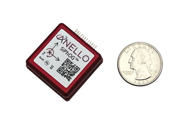
Without reliable positioning, systems lose their sense of location, direction and speed — making it impossible to navigate to their destination. Yet in modern warfare, autonomous systems and industrial automation depend on precise and continuous navigation. ANELLO Photonics is tackling this gap head-on with a breakthrough silicon photonics-based optical gyroscope (SiPhOG) technology — one that seeks to reshape how machines, soldiers and vehicles navigate across land, air and sea when satellites fall silent.
A Battlefield Blind Spot
In GPS-contested environments such as urban warzones, subterranean tunnels, dense forests or near hostile jamming equipment, traditional navigation solutions fail. Spoofing attacks can instantaneously displace autonomous vehicles by kilometers. Jamming can cripple UAVs mid-flight, causing them to crash. Even in civilian settings — especially in and around conflict zones — GPS signal loss can disrupt commercial fleets, emergency responders, and industries like mining or agriculture. These dropouts stall autonomous operations, reduce productivity, and increase the risk of severe damage.
These issues aren’t hypothetical. Adversaries have demonstrated sophisticated GPS interference capabilities that can mislead or immobilize multi-million-dollar defense assets. The need for self-contained, spoof-resistant navigation has never been more urgent.
Strategic-Grade Precision in a Chip
ANELLO Photonics took a radically new approach to building gyroscopes when it built its Silicon Photonics Optical Gyroscope (SiPhOG) using the same semiconductor processes used for integrated circuits. This breakthrough makes it possible to deliver high-precision optical navigation in a chip-scale form factor — smaller than a fingernail. The SiPhOG harnesses the proven Sagnac effect — central to traditional fiber-optic gyroscopes (FOGs) — but ANELLO has reimagined it using advanced silicon photonics, integrating this into a compact silicon photonic chip.
This innovation enables:
Bias drift < 0.5°/hr. A performance level previously only achieved by large, costly fiber-optic systems.
Nanoradian-scale angular sensitivity. Essential for accurate navigation over long durations.
Superior to MEMS. Resilient to vibration, thermal variation and EMI — ideal for combat zones and industrial environments.
Compact, coin-sized form factor. Easily integrates into existing systems and is small enough to be used for soldier-worn devices, embedded robotics and scalable mass-market applications.
The ANELLO SiPhOG offers the precision of strategic-grade FOG systems, but with the size, weight, power and cost suitable for widespread tactical deployment to the mass market. This balance makes it uniquely positioned to serve both high-end defense missions and cost-sensitive commercial markets.
The Full-Stack INS Advantage
SiPhOGs alone aren’t enough. ANELLO integrates its SiPhOGs with accelerometers, magnetometers, GPS (when available) and onboard CPU logic into a full-stack inertial navigation system (INS). Additionally, these systems use the ANELLO AI-based sensor-fusion engine to intelligently reconcile data, validate signal integrity and detect anomalies, such as jammed or spoofed GPS locations or signal dropouts across land, air and sea. The ANELLO AI sensor-fusion engine processes and tracks in real time the inertial position and GPS position every ~10 ms. The system auto-corrects and seamlessly transitions the sensor modes without any human intervention — always determining what is correct and what is false or being spoofed. The ANELLO AI sensor-fusion engine is continuously being tested and optimized by the ANELLO team with various customers in the field.
The result is a self-contained, intelligent navigation platform that maintains accurate heading, velocity and position — even in total GPS darkness. The modularity of the ANELLO systems also enables easy integration into various host platforms, from aerial drones to armored vehicles to autonomous boats and robots.
Field-Proven Resilience in Defense
During U.S. Department of Defense trials, ANELLO’s INS systems successfully identified and mitigated GPS spoofing attempts in real time. When a vehicle’s GPS feed suddenly shifted its perceived location by kilometers, ANELLO’s AI engine flagged the change as physically impossible, rejected the GPS input and seamlessly relied on ANELLO inertial data to maintain accurate positioning.
Such robustness makes the ANELLO technology suitable for:
UAVs operating in jammed or contested airspace
Autonomous Ground Vehicles (AGVs) navigating GPS-denied terrain • Marine systems facing jammed or spoofed GPS signals
Land vehicles such as emergency responders and even delivery vehicles
Handheld soldier systems that demand compact, rugged navigation capabilities for on-the-move operations.
Whether installed on armored vehicles, on drones, or embedded in next-gen infantry kits, ANELLO’s optical gyro-based solutions deliver location certainty when precision and accuracy matter.
Cross-Sector Use Cases
Autonomy Without Satellites: While defense remains a clear application, the broader commercial value is just as transformative. In agriculture, autonomous vehicles often lose GPS coverage under thick orchard canopies. In underground mines or port operations, satellites are blocked entirely. In these environments, ANELLO’s SiPhOG-powered INS continues to provide reliable localization and position, ensuring autonomous systems don’t stall, stray or crash.
Commercial applications for ANELLO’s SiPhOG technology include:
Autonomous mining vehicles. Enables self-driving trucks and loaders to navigate through tunnels and signal-blocked environments with precision and safety.
Port automation and crane systems. Supports operation of automated cranes and cargo movers in GNSS-challenged port environments for uninterrupted container handling and improved throughput.
Industrial robotics and logistics. Powers warehouse robots and inspection systems with high-precision navigation in indoor and metallic environments where GPS is unreliable or unavailable.
Autonomous maritime systems. Facilitates reliable navigation for unmanned surface vessels (USVs) and autonomous underwater vehicles (AUVs) operating in coastal, harbor, or fully submerged missions where satellite signals are compromised.
With rapid integration into commercial drones, robotic forklifts and construction fleets, ANELLO is extending military-grade navigation into everyday autonomy use cases.
Smarter Navigation in Real Time
At the heart of ANELLO’s platform is a sophisticated AI sensor fusion engine. Every 10 ms, the system ingests data from multiple sensors, validates physics-based plausibility and recalibrates its state estimates. This allows the system to detect and reject spoofed GPS signals, continue navigation autonomously through temporary GPS dropouts and identify signal degradation before failure occurs.
This intelligence is what makes the system robust, not just a fallback, but a fully capable primary navigation method in harsh and dynamic environments. It also significantly reduces the operational risk and support burden typically associated with traditional inertial systems.
Compact, Scalable, Mission-Ready
As conflicts evolve and global infrastructure expands into GPS-hostile regions, inertial systems must become smaller, smarter and more affordable. ANELLO is advancing a roadmap toward fully integrated, chip-scale INS platforms with gyros, lasers, processors and algorithms all on a single platform. This enables faster deployment in the field, lower system power consumption and broader adoption across vast use cases for military and industrial systems.
The company’s domestic chip fabrication capability also ensures supply chain security, an increasingly critical factor in national defense and industrial automation strategies. From soldier systems and UAVs to autonomous cargo vehicles and industrial robots, ANELLO’s technology is positioning itself as a cornerstone for resilient, GPS-independent autonomy.
Navigatng a Standard for a Contested World
The future of autonomous operations—military and civilian alike—will need to depend on navigation systems that do not falter when GPS disappears. With its SiPhOG-based inertial platform, ANELLO Photonics is offering not just a backup system, but a new standard: one that combines strategic-grade precision, compact design and AI-driven reliability that can be delivered to the mass market and installed into any vehicle or any moving platform.
In an era where signal denial is not just a threat but a tactic, assured positioning is no longer optional—it’s essential. ANELLO is redefining the future of navigation, empowering not just autonomous systems but also the people who rely on navigation to operate with confidence and precision — anywhere, anytime — even when the sky goes dark.
1. Anti-jamming antenna For defense, marine and critical infrastructure
The CR8894SXF+ is an advanced controlled reception pattern antenna (CRPA) for anti-jamming. It is engineered to provide efficient interference protection and real-time situational awareness across critical infrastructure, marine and defense environments where GNSS continuity is mission critical. It is specifically designed to provide a low-power and lightweight solution in a compact size. It features advanced in-band null forming to protect GPS L1/L2 and Galileo E1/E5b signals, helping ensure resilient positioning, navigation and timing in environments with contested, congested or degraded radio frequency conditions. The antenna incorporates Calian’s eXtended Filtering interference mitigation technology to maintain performance and reliability when RF threats are present. The CRPA supports in-band null-forming of 20 dB to 40 dB and out-of-band rejection up to 80 dB across 700 MHz to 2,500 MHz. It includes two independent low-noise amplifier channels, allowing continued operation if one signal band is compromised. The antenna forms nulls in both upper (L1/E1) and lower (L2/E5b) GNSS bands to actively suppress jamming sources. A serial output interface provides real-time feedback, enabling users to monitor RF conditions and system status. Calian GNSS, calian.com
2. PNT system Integrates GNSS receiver, INS, atomic clock
Photo: Safran
The BlackNaute autonomous positioning, navigation and timing (PNT) system integrates Safran’s HRG dual-core inertial navigation technology, the Skylight multi-mode GNSS receiver board, and an atomic clock to offer navigation resilience in challenging electronic warfare environments. BlackNaute’s built-in atomic clock is designed to maintain precise timing, which is essential for secure communications and collaborative combat operations. The system features advanced anti-jamming and anti-spoofing algorithms, which have been validated in more than 16,000 operational cases. These capabilities allow BlackNaute to detect compromised signals and automatically switch to autonomous and trusted navigation and timing sources to ensure continuity of operations. Its modular design allows it to be adapted across a variety of platforms. Airbus Helicopters has selected the NH90 to be equipped with this new Embedded GNSS and Time INS (EGTI). Safran Electronics & Defense, safran.com
3. Interference detection Suite enhanced for greater accuracy, coverage and insight
Photo: US Navy
HawkEye 360’s GNSS-I Detection suite includes powerful enhancements to its GNSS interference detection capabilities. The upgrades — designed with defense, intelligence and national security operations in mind — offer unprecedented accuracy, coverage and insight into global GPS jamming and spoofing threats. The update includes a new wider frequency algorithm that better distinguishes individual emitters, incorporates GPS spoofing detection, and is terrain adjusted for better geolocation accuracy, delivering greater situational awareness and more precise geolocation of interference sources worldwide. The enhanced product suite supports strategic decision-making by providing timely, precise insight into potential signal disruptions, enabling stakeholders to better assess risk, respond confidently, and maintain operational continuity in dynamic environments. HawkEye 360, he360.com
4. VTOL UAS For complex intelligence, surveillance and reconnaissance missions
Photo: ESEN
The GöKHUN unmanned aerial system (UAS) is a tactical vertical take-off and landing (VTOL) drone system developed for versatile missions on land or at sea. GöKHUN combines the compact mobility of a NATO Class I UAV with the performance data of a Class II tactical system. It uses the SP 210 FI GS 2-stroke engine from Sky Power International. With a take-off weight of up to 110 kg and a maximum fuel and payload capacity of 26 kg, the GöKHUN can remain in the air for up to 16 hours with a minimum payload. Even with a demanding sensor load of 12 kg, it can achieve a flight duration of around nine hours, making it suitable for long-endurance reconnaissance and surveillance missions. The GöKHUN’s cruising speed is between 96 and 158 km/h. The maximum range with direct line-of-sight is over 150 km, with the system reaching a service ceiling of approximately 5,500 m. ESEN, esensi.com.tr
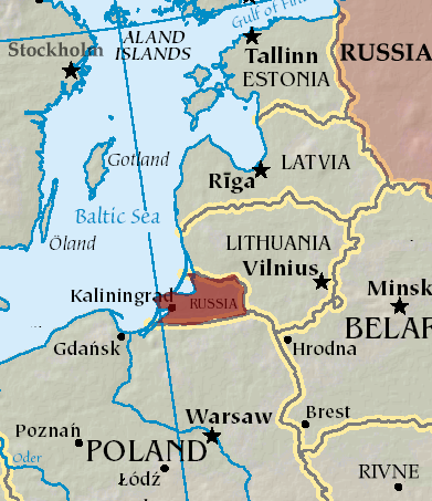
An A330 airplane carrying Spanish Defence Minister Margarita Robles experienced GPS interference while flying over Kalingrad, Russia, reports EU Today. The news outlet cites Spanish newspaper El Mundo as its source.
Robles was flying to in an aircraft belonging to the Spanish Air and Space Force. It was is “subjected to an attempt to throw it off course using GPS” over Kaliningrad as Robles was travelling to the Šiauliai air base in Lithuania on Sept. 24.
The pilot said incidents attempting to disorient pilots have been common for both commercial and military flights over Kaliningrad. Becausee this was a military craft, the plane was receiving instructions from a military satellite and the attempt failed.
A coalition of 14 major industry associations has called on the departments of Defense and Transportation to address increasing threats from GPS signal jamming and spoofing that are affecting civilian operations beyond traditional conflict zones.
The letter, signed by organizations including the GPS Innovation Alliance (GPSIA), Aircraft Electronics Association, Airlines for America and the U.S. Chamber of Commerce, was sent to Defense Secretary Pete Hegseth and Transportation Secretary Sean Duffy, outlining concerns about GPS signal interference. The letter warns that such interference is expanding beyond military conflict zones to affect civilian transportation and commerce operations in international airspace and waters.
The coalition represents industries that collectively contribute significant portions to the U.S. economy. The aviation system accounted for 5% of U.S. GDP in 2024, totaling $1.45 trillion, while ports and maritime operations contributed $2.9 trillion, nearly 10% of GDP. GPS technology has generated more than $1.4 trillion for the U.S. economy since its introduction, with more than 6 billion GPS-enabled devices in use worldwide.
The organizations are seeking coordinated action from the Trump administration to modernize GPS infrastructure and enhance its resilience against interference. The coalition has indicated its willingness to work with federal agencies on addressing what it describes as challenges to national security, public safety and economic prosperity.
System Vulnerabilities
Despite GPS maintaining a 99.99% availability rate with no recorded outages since 1993, the system faces several challenges. On-orbit satellites operate years beyond their intended design life, ground system upgrades have been delayed, and the system lacks counter-spoofing capabilities.
The coalition emphasizes that GPS serves as a foundation for modern defense, aviation, maritime operations and commercial activities. Transportation industry officials note their sector’s role as a key partner in U.S. military logistics operations.
“GPS is one of the most important innovations of the modern era, underpinning national security, critical infrastructure such as transportation, and commerce,” said Lisa Dyer, Executive Director of the GPS Innovation Alliance. “The Trump administration’s approach to “getting stuff done” is what this nation needs to finally achieve a modern GPS that is resilient to jamming and spoofing. The President’s leadership can also deter further harmful interference – actions that will benefit most critical industries that are delivering goods and services around the world and transporting passengers safely to their destinations.”
The GPSIA recommendations call for executive branch agencies to:
Accelerate the procurement and launch of modern GPS satellites and include anti-jamming and anti-spoofing technology upgrades in GPSground systems. Prepare a program plan that ensures GPS is technologically more advanced than China’s BeiDou and Europe’s Galileo GPS-like systems.
Strengthen enforcement and coordination across the U.S. government to rapidly identify and respond to interference events and crack down on illegal sales and use of jamming devices.
Streamline regulatory and certification processes to accelerate adoption of advanced technologies such as jam- and spoof-resistant antennas, modern GPS signals, and anti-spoofing signal authentication in airframes, receivers and devices.
Deter interference through public statements and diplomatic engagement, making clear the United States will not tolerate harmful jamming and spoofing outside conflict zones that risks public safety and impedes commerce.
“These are concrete, achievable actions that, if pursued, will ensure the integrity, continuity, availability, and resiliency of GPS. This approach also offers the commercial position, navigation, and timing industry time to mature and deploy their technologies so that they can meet the high regulatory bar that is appropriately set for public safety applications,” Dyer said.