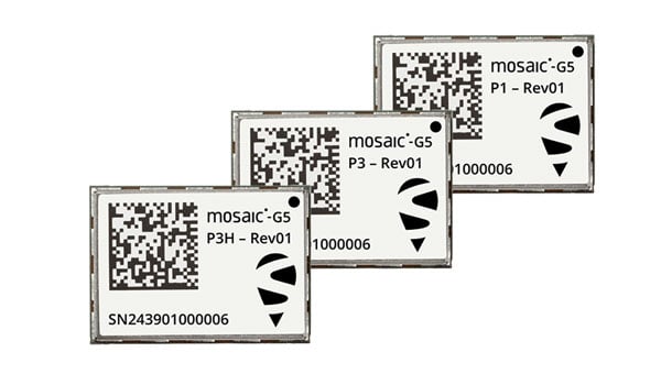
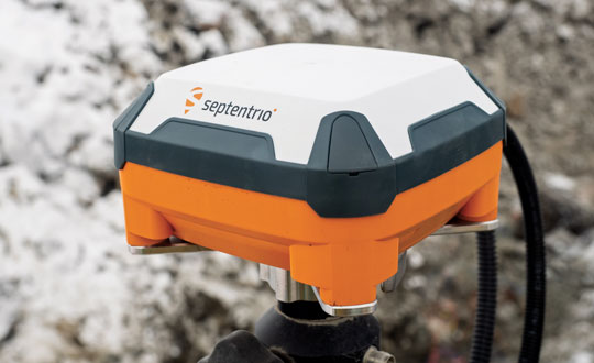
Septentrio, part of Hexagon, has introduced the mosaic-G5 series, expanding its line of compact GNSS receiver modules. The mosaic-G5 modules offer a 60% reduction in size and a 40% decrease in power consumption compared to the earlier mosaic-X5 receiver. The new modules measure 23 mm x 16 mm and weigh as little as 2.2 g, making them suitable for applications where size, weight and power are critical considerations, such as commercial UAVs, robotics and high-volume industrial equipment.
The mosaic-G5 modules offer reliable, high-accuracy positioning even in environments where GNSS signals may be degraded or obstructed. The mosaic-G5 product line includes several variants tailored to different use cases. The triple-band mosaic-G5 P1 is designed for high-volume applications, such as inspection drones and robotic mowers. The quad-band mosaic-G5 P3 and the triple-band heading module mosaic-G5 P3H offer enhanced positioning reliability in challenging conditions and are suited for applications such as delivery UAVs and light show UAVs. The P3H variant can calculate heading with a minimal baseline between two GNSS antennas, enabling accurate navigation for small autonomous device.
The new modules complement the mosaic product line, where the mosaic-X5 receiver remains as the benchmark for world-leading GNSS open signal anti-jamming and anti-spoofing resilience in a small form factor.
The mosaic-G5 modules complement Septentrio’s broader mosaic portfolio, which is recognized for its all-band GNSS technology, accuracy, reliability, and resilience to jamming and spoofing. The established mosaic-X5 receiver remains a benchmark for anti-jamming and anti-spoofing performance in a compact form factor. Like the mosaic-X5, the new modules are compatible with widely used open-source autopilots, such as PX4 and ArduPilot, simplifying integration and reducing development time. An evaluation kit, mosaic-go G5, is available to facilitate testing, and the RxTools user interface is provided for setup and evaluation.
Samples of the new mosaic-G5 P1, mosaic-G5 P3, and mosaic-G5 P3H modules are now available, with volume orders available for delivery later this year.
Read a roundup of recent products in the GNSS and inertial positioning industry from the May 2025 issue of GPS World magazine.
SURVEYING
Integrated Navigation Solution Ideal for inspection and survey applications
Photo: Teledyne
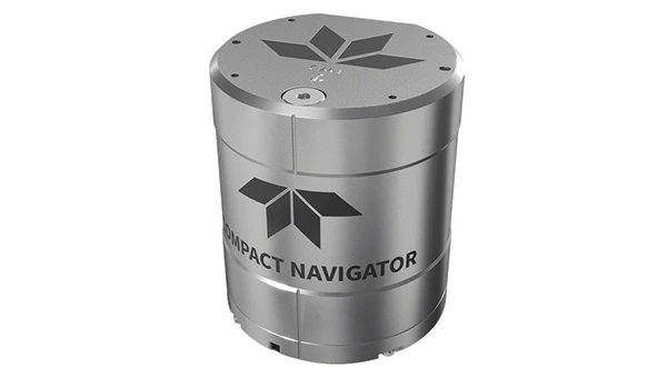
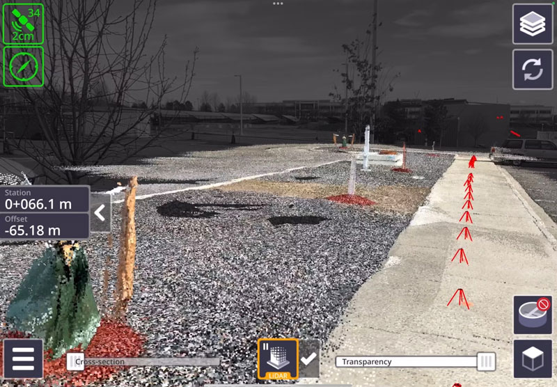
Teledyne Compact Navigator is an ultra-compact autonomous integrated navigation system engineered for subsea and surface vehicles. It is ideal for small vehicles, enabling inspection and survey operations on compact platforms. The system is offered in two depth-rated models, one capable of operating at 4,000 m and another at 300 m. The Compact Navigator consumes less than 7 watts of power, extending mission duration by conserving energy. The system operates fully autonomously, eliminating the need for external aiding or operator intervention. Advanced phased array Doppler Velocity Log technology enhances performance while allowing the device to be mounted on an autonomous underwater vehicle or ship hull.
The Compact Navigator supports a broad range of applications, including autonomus underwater vehicles, shallow water surface navigation, operations in GNSS-denied environments and dynamic positioning for surface vehicles. The system provides true North-seeking gyrocompass-grade performance, and its web-based user interface supports integration, operation and troubleshooting. It is factory-calibrated and offers a battery backup option for reliability in demanding conditions. The system operates independently of satellite signals, making it resistant to jamming or signal loss. This capability is significant for shallow water navigation, where GNSS-based systems may be unreliable.
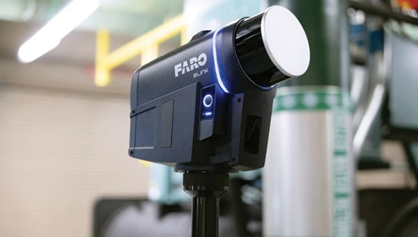
3D Reality Capture Solution Can be used across various industries
Photo: Faro
FARO Blink, a new 3D reality capture solution, is designed to make collecting and utilizing 3D data more accessible and efficient. It centers on software-driven technology integrating advanced visualization and automated workflows through the FARO Sphere XG Digital Reality Platform. This integration aims to simplify operations and deliver faster, more actionable insights for users across various industries.
FARO Blink is tailored for professionals in fields such as surveying and construction. It offers high-quality visualization and can streamline workflows, allowing teams to efficiently capture, view and share 3D data, thereby enhancing project progress and collaboration.
The MS400C is a fully integrated multibeam echosounder designed for uncrewed surface vessels. The new system combines sonar processing, inertial navigation, GNSS positioning and sound velocity sensing into a single unit.
The MS400C seeks to address deployment challenges faced by USV operators during hydrographic surveying. Its compact, lightweight design allows direct mounting on small platforms. Installation involves connecting a few cables to the IPC and power supply and to the primary and secondary GNSS antennas. With preconfigured spatial relationships, operators can deploy and start surveying quickly, reducing configuration errors and ensuring consistent data quality.
Equipped with Auto Survey functionality, the system calibrates parameters based on water conditions, which streamlines pre-survey procedures. Real-time roll compensation and attitude data from the internal measurement unit, combined with sound velocity profiling, ensure high-fidelity depth measurements, even in dynamic conditions. Designed for autonomous and remotely operated survey platforms, the MS400C supports data collection in confined waterways.
The SurveyPod RTK/PPK GNSS system is built for professionals in surveying, agriculture, mining and construction. The system integrates GPS, GLONASS, Galileo and BeiDou signals for improved satellite visibility and accuracy, even in harsh environments.
Powered by a CORS Network, SurveyPod offers real-time, centimeter-level positioning ideal for high-precision applications. The device supports tilt compensation for reliable data collection at angles and boasts up to 16 hours of battery life, making it ideal for extended field operations. With this launch, Nibrus Technologies is expanding its survey equipment portfolio, offering a Made-in-India GNSS solution to the global market.
This MEMS-based north-seeking inertial measurement unit (IMU) operates independently of GNSS. It can achieve a heading accuracy greater than 1° secant latitude without GNSS assistance. When integrated with GNSS and SBG Systems’ navigation algorithms, it can achieve INS heading accuracy greater than 0.01°.
Measuring 52 x 52 x 36 mm and weighing less than 150 g, it consumes only 2 watts of power. It offers long-term reliability in demanding conditions, and its ITAR-free status allows unrestricted global deployment. SBG Systems also has developed a new pure north-finding algorithm capable of rapid initialization in both static and dynamic conditions within one minute, as well as an advanced GNSS/INS fusion algorithm that delivers exceptional single-antenna heading accuracy even in low-dynamic environments.
The IMU is particularly suited for subsea applications, including remotely operated vehicles and autonomous underwater vehicles, as well as geospatial and marine surveying tasks requiring precise single antenna heading accuracy.
The first off-the-shelf solutions are expected to be available by early 2026. SBG Systems
Post-Processing Software With upgraded features
Photo: SBG Systems
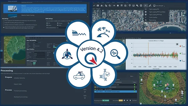
Qinertia 4.2 is an updated version of SBG Systems’ post-processing software for GNSS and INS data. One of the notable additions is the beta version of Precise Point Positioning Fixed Ambiguity, which offers centimeter-level accuracy processing without the need for a base station. The update also includes a new RTS smoothing option, the Trajectory Smoother, which enhances INS processing by removing artifacts while maintaining precision. Another feature is the standalone Lever Arm Estimation Tool, now available as a separate application with a simplified interface. The Advanced Virtual Base Station Network Creation has been enhanced with improved base station quality indicators to increase reliability.
It is compatible with the New Ellipse series and supports Teledyne Intrepid INS. The software now offers faster processing speeds, enhanced geodesy functionalities such as base station velocity analysis, and updated tools for assessing processing quality through new status plots. It also supports the latest firmware versions of Ekinox, Apogee, Navsight and Quanta systems. SBG Systems
MACHINE CONTROL
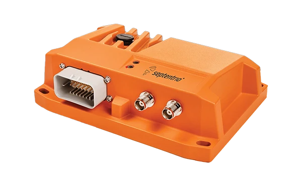
GNSS Receiver and INS System For machine guidance
Photo: Septentrio
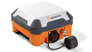
The AsteRx RB3 GNSS receiver and the AsteRx RBi3 GNSS/INS system are designed to operate in extreme environments. They feature IP69K-rated housings and components that have undergone ISO-standard testing.
The technology offers durability under heavy shocks, vibrations and challenging environmental conditions, making it suitable for demanding applications such as construction, mining and port automation.
The AsteRx RB3 and RBi3 utilize multi-frequency GNSS technology to deliver precise, centimeter-level positioning even in environments where GNSS signals are typically difficult to maintain. The receivers can be mounted externally on heavy machinery or integrated into chassis systems, offering flexibility in placement and simplifying installation.
The AsteRx RBi3 incorporates FUSE+ technology, which combines a high-performance GNSS engine with an industrial-grade inertial sensor. This integration provides accurate orientation data, such as heading, pitch and roll, alongside reliable positioning. In dual-antenna configurations, the receivers deliver sub-degree GNSS heading accuracy immediately upon initialization. The AsteRx RB3 and RBi3 are ideal for machine guidance in industries requiring rugged equipment to maintain precision under extreme conditions.
Handheld Reality Capture Solution For maximum mobility
Photo: Topcon Positioning
Designed for mass data solutions, the CR-H1 utilizes PIX4Dcatch, a specialized application with integrated lidar that runs on iPhone devices. It collects images and employs photogrammetry to create detailed, full-color 3D point clouds. The iPhone connects to Topcon’s HiPer CR receiver, enabling the application to collect georeferenced images. The receiver and iPhone are mounted on a specialized handle designed and manufactured by Topcon so that users can capture point clouds without a tripod.
The CR-H1 can be used for utilities and subsurface mapping, construction verification and earthworks, civil engineering and site verification, land surveying and forensics and 3D data capture. Topnet Live subscriptions are available for the CR-H1, providing real-time GNSS corrections that deliver higher-quality point clouds.
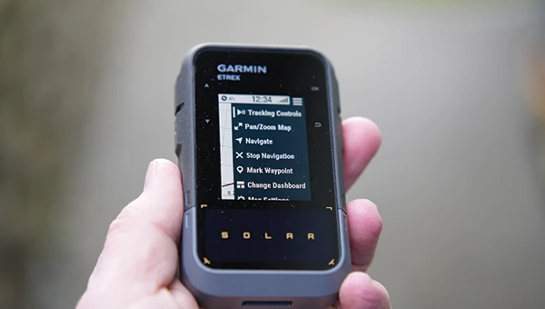
Handheld GPS Device Can provide up to 200 hours of GPS navigation on a single charge
Photo: Garmin
The Garmin eTrex Solar is a handheld GPS device with a built-in solar charging feature. This feature allows for potentially unlimited battery life in optimal sunlight conditions. Even without direct solar input, the device can provide up to 200 hours of GPS navigation on a single charge, making it suitable for extended trips with limited access to power.
The device supports GPS, GLONASS, Galileo, QZSS, IRNSS and Beidou. It features a rugged design, an IPX7 water resistance rating, and a compact, lightweight body that can be attached to a backpack or worn around the neck. Users can import GPX files and navigate to waypoints, courses and geocaches. It also includes a three-axis compass and can store up to a thousand waypoints, 50 courses and 200 activities.
Users can connect the eTrex Solar to their smartphones through the Garmin Explore app, which enables additional features such as geocaching details, weather updates, software updates, trip planning, and cloud storage syncing.
New Product Offerings Now featuring marine GNSS antennas
Photo: Geo-matching
Geo-matching has expanded its product database to include GNSS antennas. The initial marine GNSS antennas featured in this new category are the VP6300 from Calian GNSS, formerly Tallysman, and the AV34 from Trimble.
Geo-matching features detailed information on more than 1,300 products across 63 categories for surveying, navigation and machine guidance. The website is designed to guide users through complex product specifications, offering access to brochures, case studies, product videos and professional reviews. Among the many categories available on Geo-matching.com are hydrographic processing software, GNSS receivers, GIS software, inertial navigation systems, total stations, UAVs, sidescan sonars, imaging sonar and more. The platform encourages users to browse its extensive catalog, upload new products, leave reviews and register their companies to add products to the database.
Mapping UAV With a new “Smart Return-to-Home” feature
Photo: Flyability
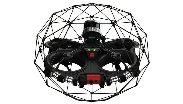
Flyability has introduced a “Smart Return-to-Home” (RTH) feature for its Elios 3 UAV, designed to enhance its autonomous capabilities. This feature allows the UAV to return to its take-off point using the shortest available path while avoiding obstacles in real time.
During flight, Smart RTH monitors battery levels through a new flight management gauge, notifying the pilot when it is time to return. The feature is activated via Flyability’s Cockpit flight app, and pilots can take manual control at any point. By automating the return process, the system helps pilots focus on inspections without concerns about battery management or navigation in complex environments. Smart RTH uses lidar scans to generate a flight plan that the UAV executes independently.
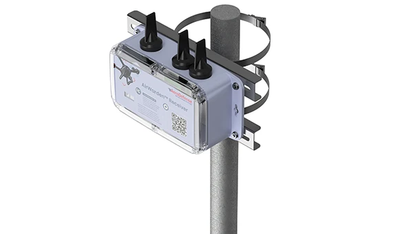
The AirWarden Remote ID Receiver detects and decodes Remote ID signals broadcast by UAVs. It is designed for organizations and authorities that need to monitor UAV activity for safety, security and compliance with regulations.
It decodes the information transmitted by UAVs in accordance with FAA and other regulatory standards. The data it captures includes the UAV’s identification number, its precise location (latitude, longitude and altitude), the takeoff location, operator location if available, timestamps, and other relevant metadata.
The AirWarden can be deployed as a standalone unit or integrated into larger security and monitoring systems. Users interact with the system through a web-based or software interface that facilitates live monitoring, alert management, and data analysis.
Additionally, the AirWarden can integrate seamlessly with other security infrastructure, such as video surveillance and access control systems. This integration seeks to improve how security teams automate responses and coordinate actions when unauthorized or suspicious drone operations are identified.
Septentrio, a division of Hexagon, has introduced two new products, the AsteRx RB3 GNSS receiver and the AsteRx RBi3 GNSS/INS system. These receivers are designed to operate in extreme environments, featuring IP69K-rated housings and components that have undergone rigorous ISO-standard testing.
The technologies robust construction ensures durability under heavy shocks, vibrations and challenging environmental conditions, making them suitable for demanding applications such as construction, mining and port automation.
The AsteRx RB3 and RBi3 utilize multi-frequency GNSS technology to deliver precise, centimeter-level positioning even in environments where GNSS signals are typically difficult to maintain. The receivers can be mounted externally on heavy machinery or integrated into chassis systems, offering flexibility in placement and simplifying installation.
The AsteRx RBi3 incorporates FUSE+ technology, which combines a high-performance GNSS engine with an industrial-grade inertial sensor. This integration provides accurate orientation data — such as heading, pitch and roll — alongside reliable positioning. In dual-antenna configurations, the receivers deliver sub-degree GNSS heading accuracy immediately upon initialization.
The AsteRx RB3 and RBi3 are ideal for machine guidance in industries requiring rugged equipment capable of maintaining precision under extreme conditions.
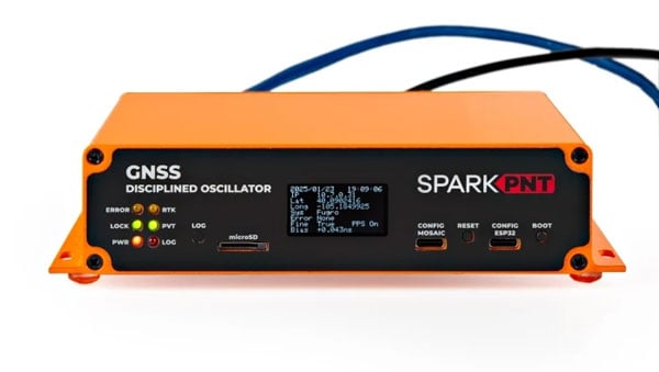
SparkFun Electronics has introduced its first ultra-high-precision GNSS timing product, the SparkPNT GNSS Disciplined Oscillator (GNSSDO). Designed for applications requiring sub-nanosecond timing and frequency precision, the GNSSDO is built around Septentrio’s multi-constellation, multi-frequency, L1/L2/L5-ready mosaic-T module.
The device integrates Septentrio’s mosaic-T GNSS timing receiver, Espressif’s ESP32-WROVER processor and the SiTime SiT5358 disciplined 10 MHz oscillator on a single circuit board. It is housed in a custom extruded aluminum case with machined end panels and slotted flanges, making it suitable for installation in weatherproof enclosures or server racks.
The GNSSDO offers impressive timing precision. Its time pulse accuracy is 5 ns, which improves to under 1 ns with an optional subscription to Fugro AtomiChron via L-Band. Event accuracy is less than 20 nanoseconds.
To ensure reliability and security, the Septentrio mosaic-T module provides robust performance even under challenging conditions such as GNSS jamming or spoofing. The system’s multi-constellation and multi-frequency capabilities, combined with AIM+ technology, are designed to enhance resilience. Additionally, the integration of SiTime’s Super-TCXO ensures superior clock frequency stability and accuracy during GNSS outages.
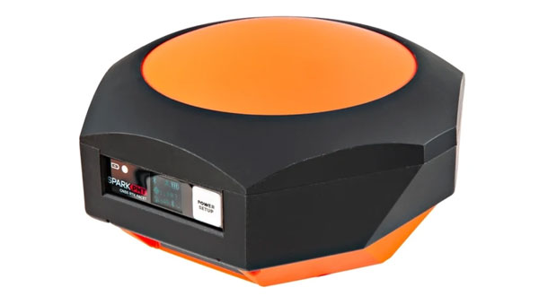
SparkFun Electronics has released the SparkPNT RTK Facet mosaic L-Band, a high-precision geolocation and surveying receiver. It features Septentrio’s multi-band mosaic-X5 and offers centimeter-grade measurements with 6 mm RTK fixes available in less than one minute, according to Sparkfun.
The receiver can connect to phones or tablets via Bluetooth, allowing NMEA output compatibility with most geographic information system software. It uses u-blox’s PointPerfect service for corrections, broadcast from a geosynchronous Inmarsat satellite.
The RTK Facet mosaic L-Band features an ESP32 WROOM connected to a mosaic-X5 GNSS multi-band receiver, along with peripheral hardware. It includes a surveyor-grade L1/L2/L5-Band antenna designed to receive GNSS signals and PointPerfect correction.
The device operates in various modes, including GNSS positioning, GNSS positioning with RTK L-Band, GNSS positioning with RTK, GNSS base station and GNSS base station NTRIP server. In rover mode, it can achieve 6 mm to 60 mm horizontal positional accuracy.
As an open-source hardware product, users can access and modify the electrical and mechanical design files. The kit includes the enclosed device, thread adapter, charger, data cables and carrying case.
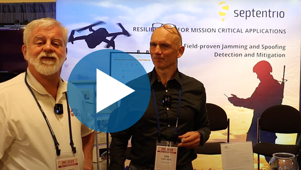
Jan Van Hees, vice president of business development and product management at Septentrio, talks about the Joint Navigation Conference (JNC) 2024 and Septentrio’s jamming and spoofing solutions.
Septentrio has introduced the mosaic-G5 series, a new range of GNSS receiver modules tailored for robotics and other applications requiring compact components.
These modules represent a significant advancement in size and power efficiency, offering a 60% reduction in size and 40% lower power consumption compared to the mosaic-X5 receiver while maintaining high performance standards. This improvement enables reliable, high-accuracy positioning for devices where minimal size, weight, and power are critical, such as commercial UAVs, compact industrial robots, and high-performance handheld devices.
The mosaic-G5 series expands Septentrio’s existing mosaic portfolio, known for its all-band GNSS technology and robust performance in accuracy, reliability, and resistance to jamming and spoofing. This broad product lineup provides users with the flexibility to select the most suitable module for their specific design requirements.
The mosaic-G5 modules will be gradually released throughout 2025.
Septentrio has partnered with GNSS Store to expand its product ecosystem. Through this collaboration, GNSS Store has developed a range of new products, including evaluation boards, dongles, compact smart antennas and other plug-and-play systems. These products are based on Septentrio’s mosaic GNSS module family, which includes the mosaic-X5 positioning module, mosaic-H heading module and mosaic-T timing module.
The mosaic GNSS receiver is a compact device that delivers high-precision positioning using tri-band technology. Its advanced built-in features offer robust protection against signal interference, including jamming and spoofing attempts.
GNSS Store’s new offerings can achieve sub-centimeter location accuracy through a combination of multi-band, multi-constellation and high-precision RTK capabilities. This level of precision makes them ideal for applications requiring extreme accuracy, such as precision agriculture, UAVs and robotic systems.
Change from one generation of GNSS receivers to the next is generally evolutionary, not revolutionary. As with other technologies, it follows a feedback loop between end-user requirements and technical advances. Additionally, GNSS receivers can now take advantage of four full GNSS constellations, two regional ones, and a plethora of corrections/augmentation services — and increasingly must be able to counter jamming and spoofing.
To get the perspective of GNSS receiver manufacturers on these issues, I asked four questions to the following company representatives:
For longer versions of their responses, as well as responses from additional companies, visit here.
Question: What is currently the best way to take full advantage of the large number of GNSS satellites — four full constellations and two regional ones — and of the many corrections/augmentation services?
Korsakissok: Many satellites in view means greater precision in urban areas, where the view of the sky is partially masked, better resilience to adversity (jamming, spoofing, constellation disruption) and, more generally, greater precision even with a clear view of the sky, thanks to local augmentations. Users working on autonomous vehicles are asking for these advantages, with the goal of achieving a certified and secured system. Technically, to have an optimal usage of this multiplicity of satellites and signals, a receiver should be able to make a fix, even with one or two satellites of each constellation in view, as we do at Syntony. Practically, because of the heritage, it is not so often the case: Many receivers, even today, make a position, velocity and time (PVT) calculation with GPS first and then use the other signals to improve it.
Lopez: To fully leverage all GNSS constellations and regional systems, it is essential to utilize multi-constellation and multi-frequency receivers that significantly enhance accuracy and reliability. These advanced receivers not only improve performance by accessing a broader range of satellite signals but also ensure consistent positioning in challenging environments, such as urban areas with tall buildings or rural regions with obstructed views of the sky.
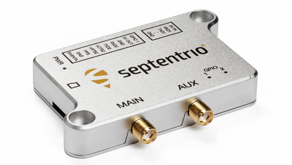
Septentrio’s antarx is a rugged GNSS/INS multi-frequency smart antenna. (Photo: Septentrio)
Some GNSS manufacturers limit signal usage due to inadequate hardware that cannot track multiple signals and their desire to reduce costs (e.g., CPU power or the number of signal tracking components). Effectively tracking multiple signals and constellations necessitates a robust hardware architecture as well as efficient algorithms that can operate optimally in compact embedded systems to fully leverage all available signals in space. At Septentrio, we prioritize maximizing all available signals to deliver the best possible performance for users while ensuring that our solutions remain valuable and accessible for a variety of applications.
Utilizing multiple GNSS signals not only enhances accuracy, availability, and reliability but also improves resilience and GNSS security, offering crucial protection against jamming and spoofing — issues that are becoming increasingly critical for many applications. Moreover, manufacturers must prioritize compatibility with various correction systems, which provide real-time data to improve positional accuracy further. Ensuring that receivers can seamlessly integrate with multiple correction services allows for smooth adoption across diverse market applications, catering to the unique needs of different industries.
To meet market demand, Septentrio has developed the Agnostic Corrections program, enabling customers to select from a range of well-established and affordable correction services. This approach offers flexibility and access to key service providers in the industry. Since these services support various signals, the advantage of our receivers is key to accommodate the wide array of signals and format messages used by these correction services.
At Septentrio, optimizing these elements is central to our vision and strategy for GNSS core technology. By focusing on performance, reliability, and compatibility, we aim to deliver innovative solutions that meet the evolving demands of the market while maintaining our commitment to excellence in GNSS technology. This strategic approach not only enhances the user experience but also positions Septentrio as a leader in the GNSS field.
Wang: To fully benefit from commercial PPP corrections, receivers must be capable of receiving signals from all GNSS constellations and frequency bands, and support SBAS and L-band services. On the software side, optimizing GNSS satellite utilization involves feeding the navigation filter with a wide range of observations from each available constellation. This, combined with adaptive interference mitigation algorithms and receiver autonomous integrity monitoring (RAIM) techniques, can greatly enhance the robustness and resilience of GNSS solutions in challenging environments such as urban canyons, interference, and spoofing.
Farrokhi: Regional services are categorized as augmentation systems. They are offered through both satellites and terrestrial systems. Satellite-based augmentation systems include but are not limited to SBAS, WAAS, AGNOS, MSAS, GAGAN, NavIC and QZSS. Terrestrial augmentation systems include but are not limited to GBAS, and GLS. Correction services include but are not limited to RTK and PPP.
Supporting these regional and correction services along with multi-band support increases the complexity of the receiver hardware and associated firmware. It is important to note that not every application or use case requires all these different services. For instance, asset tracking utilizing battery-operated tags do not require correction services or L5 acquisition. Low-power operation and simplicity of the GNSS receiver is key to longevity of operation in such applications.
The selection of correction service is highly dependent on the type of communication pipe supported by the hardware. For instance, L-band capability is required for satellite-based correction services, whereas LTE is needed for terrestrial based services.
Ching: I think one of the best ways is to embrace all the available signals on hand. What that means is with the luxury of redundancy, the system can select the best signals to use into the position estimation algorithm. Our OEM7 uses multiple constellations (GPS, GLONASS, Galileo, BeiDou, QZSS and NavIC) and multiple frequency bands (L1, L2, L5 and E6).
Q: Are the requirements for different end user applications — for example, surveying vs. fleet tracking — still very different or are they converging as capabilities increase?
Cerber CRPA Receiver with four-channel antenna and Constellator CRPA simulator. (Photo: Syntony)
Korsakissok: In a way, everybody is benefiting from better precision year after year, using the standard open signals; related to that, we can say that the solution capabilities are converging. A bit. However, we do not see everybody converging toward a “high precision real-time PVT every time everywhere.” Bringing 20-cm precision to a truck-tracking application is nice, but nobody will ever want to pay for this, if it is not relevant for how they use the application. Conversely, for precision agriculture, precision mining and autonomous vehicles, it will always be required, and they will be able to pay for the precision, when associated with reliability, in order to achieve the targeted level of safety.
Lopez: Although GNSS technology has evolved significantly in recent years due to the growing demand for accuracy across new applications, the requirements among different applications remain highly varied. Some may need centimeter-level precision, while others are satisfied with accuracy within 10 centimeters. Survey-grade applications still demand millimeter-level accuracy, while certain autonomous systems may only require 1 to 10 centimeters of precision. Additionally, the environments in which these applications operate vary, such as a surveyor working in unobstructed ground conditions versus a drone navigating through complex airspaces, where jamming, signal availability, and interference can affect performance.
The increasing number of applications that rely on accuracy has resulted in diverse requirements across the board. This is why customers seek more flexible GNSS receivers to balance availability, accuracy, and reliability based on the specific use case. There’s a broad spectrum of needs — not only in GNSS performance (accuracy, time to fix, reliability) but also in security (anti-jamming, anti-spoofing, cybersecurity) and hardware design. For example, some users need compact solutions for small form-factor devices, while others prefer robust systems that can endure harsh environmental conditions. A surveyor, focused on achieving high accuracy, may not need the same GNSS resilience required by critical infrastructure or autonomous systems, where safety mechanisms are crucial.
As more prosumer and innovative applications advance, their needs differ from those of industrial or critical-use cases. At Septentrio, we offer solutions that fill the gaps when lower-end options fall short, attracting customers dissatisfied with third-party products that fail to meet their needs. Septentrio also provides enclosure solutions with stringent environmental protection requirements, including water resistance, humidity control, vibration tolerance, and corrosion resistance.
While GNSS technology continues to advance and become more sophisticated, we also see that the gap between different applications is narrowing. Fleet tracking, for instance, is beginning to benefit from more precise positioning and the ability to use multiple GNSS constellations for autonomy — features traditionally reserved for high-precision applications such as surveying. The cost of high-precision GNSS receivers is also decreasing, making advanced features more accessible across various industries.
However, this increased autonomy introduces new demands, such as top performance and safety in complex environments, and seamless integration with sensor fusion and other ecosystems. Traditional GNSS receivers used for basic fleet tracking will not meet the needs of these advanced use cases, even if they remain part of the same vehicle or platform.
In summary, despite a trend toward the convergence of GNSS capabilities that enhance accuracy, the core requirements of these applications remain distinct, challenging the industry to develop more universally applicable solutions.
Wang: From our point of view, while GNSS performance is steadily improving, manufacturers still need to strike a balance among cost, accuracy, and availability to meet the diverse requirements of different user applications. In surveying, for example, accuracy is the top priority, while in transient control, integrity and availability are more critical. Although GNSS capabilities are increasing and some convergence of requirements is occurring, significant differences remain, necessitating careful design and optimization by manufacturers to address these varying needs.
Farrokhi: The requirements for surveying, for instance, do not apply to the rest of the market. For surveying, extreme accuracy is a must, hence utilizing RTK services and the cost of the solution is usually high. On the other hand, asset tracking, for instance, can benefit from high sensitivity, low power, low cost and cloud processing to reduce power consumption in the asset tracking device.
Generally speaking, the GNSS market falls into the following categories:
Low power, low cost — such as asset tracking
High precision — e.g., surveying and agriculture
High precision, with high reliability — such as ADAS
High speed, high G — in defense applications
Anti-jamming and anti-spoofing — such as in avionics and defense
etherWhere’s next generation hardware solution enables the convergence of all these disparate applications onto one hardware platform by utilizing flexible software and cloud processing.
Ching: Ultimately, regardless of applications, users want the reported positions that are accurate with trustworthy quality indicators. As capabilities increase, I expect more requirements to converge. For example, both surveying and fleet-tracking applications need to operate during ionospheric scintillations. Having a robust positioning solution in both applications is essential. Hexagon | NovAtel released updated firmware (versions 7.09.01 and 7.09.02) in April 2024 to increase ionospheric resilience.
Q: What is the best way to integrate complementary sources of PNT — such as LEO satellites and ground-based systems — into end user hardware and software, to maximize resilience during GNSS disruptions or outages?
Korsakissok: Such integration will be eased for all the new sources that can be acquired with the same RF stages, meaning mostly L-band as of today. SBAS has paved the way and emits at the same carrier frequency as the classic GNSS. U.S. and European low-Earth orbit positioning, navigation and timing (LEO-PNT) projects have included such signals in L-bands, and other telecom constellations can also be used that way (Inmarsat, Iridium, etc.). Because of this, all these L-band extensions to classical GNSS will be the first in line on everybody’s roadmap. When C-band signals will be emitted by GNSS constellations, then telecom ones could also be easily integrated. However, that will take many years.
Lopez: To enhance resilience during GNSS disruptions or outages, integrating a multi-layered approach with complementary sources of positioning, navigation, and timing (PNT), such as LEO satellites and ground-based systems, into end-user hardware and software is crucial. While GNSS technology will remain essential, the combination with other technologies such as inertial sensors and sensor fusion will become increasingly important as these solutions become more available.
Although alternative PNT mechanisms can bolster resilience, the strengths and protections at the core of GNSS are vital for many applications, especially since GNSS manufacturers possess the expertise to address jamming and spoofing effectively. This layered security approach resembles the “onion model” in cybersecurity — adding more security layers enhances protection against disruptions.
While LEO technology is advancing, its full value for PNT may take a few more years to materialize. In the meantime, other sensor technologies, such as inertial navigation systems (INS), already provide significant benefits in the absence of GNSS or in the most difficult conditions to GNSS.
At Septentrio, we are committed to developing products that invest in sensor fusion technologies (GNSS/INS), and we actively participate in key LEO programs that promise substantial improvements in resilience and other PNT aspects, including GNSS corrections and enhanced multipath mitigation for optimal performance in challenging environments. We view this evolution as critical to our product roadmap and consider it a strategic priority for our company.
Wang: The foundation of an effective positioning system is robust hardware that supports the integration of multiple PNT sources. Building on this multi-source signal base, a set of advanced algorithms is necessary to selectively use the signals and filter out interference, enabling the seamless fusion of these sources and achieving superior performance. Moreover, redundant and backup filters are crucial for maintaining the robustness of the positioning solution, particularly during GNSS disruptions or outages.
Farrokhi: etherWhere’s next-generation solution supports LEO constellations such as Xona Space to enhance location tracking and provide resilience and redundancy. LEO satellites signal strength is higher than GNSS satellites due to their lower orbit and as such provide better link margin. The key to ubiquitous adoption is in a well-integrated single chip solution at lower power consumption.
Ching: Complementary sources of PNT must be proven to provide a consistent improvement in positioning performance, beyond what GNSS alone can provide. For example, increasing availability is not helpful if the quality indicators cannot be trusted. The integration must be an overall benefit to the user, in terms of ease of use, positioning performance and reliability. Our team is already leading the market and working with key stakeholders and partners to provide PNT beyond GNSS as we announced in previous years.
Q: What are the key innovations in your latest receiver or generation of receivers?
Korsakissok: Syntony is well-known to have one of the first full SDR embedded receivers, working in multi-frequency and multi-constellation mode. Thanks to that, we were able to be the first to demonstrate the coupling with XONA, at ION GNSS in 2022, and have been chosen by the European Space Agency (ESA) for their own LEO PNT: Flexibility and ease of modification are the major advantage of full SDR, versus ASICS.
Today, our SDR receiver is embedded in cars, trains, UAVs, launchers and satellites, but also in trucks for underground mining, together with our SubWAVE solution. Not to mention our CRPA version, which is capable of state-of-the-art anti-jamming level, completed by exclusive anti-spoofing mitigation, as we can compare, directly inside the receiver, the direction of arrival of all GNSS signals with the ephemeris, avoiding retaining and tracking the ones that are spoofed.
Lopez: This year, Septentrio has achieved notable advancements in GNSS receiver technology by enhancing resilience against jamming and spoofing and by launching the AntaRx product line. It offers high-precision performance, a durable design, and versatility for industrial applications, such as construction and mining. With advanced anti-jamming and anti-spoofing across all products, plus the AntaRx — which is an all-in-one GNSS, antenna, and sensor fusion solution — we remain committed to delivering the most reliable positioning in the most challenging environments.
Lopez: In response to evolving market demands and guided by our strategic vision, Septentrio has made significant advancements in GNSS receiver technology, focusing on two major pillars: resilience and performance.
Resilience: Septentrio has established a reputation for providing robust GNSS solutions thanks to our AIM+ technology, and we remain committed to enhancing resilience across our product line. Our latest innovations have significantly improved our receivers’ ability to detect and mitigate spoofing attacks. These enhancements have been validated through rigorous testing, including recent GNSS jamming tests conducted in Norway (see Norway results here), as well as field applications where our receivers have successfully operated in contested environments, particularly within drone applications. This continued focus on resilience ensures that our customers can rely on our technology even in challenging conditions where signal integrity is paramount.
AntaRx Product Portfolio: This year, we proudly launched the AntaRx product line, specifically designed to meet the rigorous demands of industrial applications such as construction, mining, and robotics. The AntaRx series offers a variety of configurations, including single-frequency, dual-frequency, and inertial variants (GNSS/INS), providing unparalleled flexibility for a wide range of use cases (see more about this product here).
What sets the AntaRx apart is its exceptional high-precision GNSS performance combined with core reliability. This product line is compatible with various correction services, allowing users to achieve optimal accuracy regardless of their operational environment. Moreover, the AntaRx features advanced anti-jamming and anti-spoofing technologies, which are critical for ensuring the integrity of positioning data in areas where interference is prevalent.
In addition to its technological innovations, the AntaRx is designed with ruggedness in mind. It is built to withstand harsh environmental conditions, making it suitable for deployment in demanding industries. The user-friendly interface simplifies operation and enhances the user experience, ensuring that both seasoned professionals and newcomers can easily integrate the technology into their workflows.
Furthermore, the AntaRx incorporates sophisticated sensor fusion capabilities, combining GNSS with inertial data to enhance overall positioning accuracy and reliability. This integration is particularly beneficial in environments where GNSS signals may be obstructed or unreliable. The careful design of the AntaRx, which includes an integrated antenna and GNSS components, significantly improves multipath mitigation, further ensuring optimal performance even in challenging conditions.
In summary, Septentrio’s commitment to innovation is evident in our latest GNSS receiver developments. By focusing on resilience and advanced capabilities, particularly with the launch of the AntaRx product line, we aim to provide our customers with the most reliable and high-performing GNSS solutions tailored to meet the diverse demands of various industries. As technology continues to evolve, we will remain dedicated to enhancing our products to meet the future challenges of positioning, navigation, and timing.
Wang: Our newest product, the RS10, leverages cutting-edge technologies to achieve seamless integration of GNSS with SLAM, vision, and INS. This fusion has resulted in the RS10 delivering enhanced accuracy and reliability while providing an exceptionally efficient solution for the surveying and mapping industries. By combining these complementary technologies, we’ve made a significant leap forward in advancing the performance and capabilities to benefit geospatial professionals.
Farrokhi: At etherWhere, we have innovated on multiple fronts to address different use cases.
These innovations include:
AccuWhere Cloud to address the requirements for low-power, battery-operated asset trackers.
Hybrid Constellation to address the simultaneous processing of the four GNSS constellations along with LEO signals of opportunity (SOP) to provide resilience and redundancy.
ArrayNav adaptive multi-antenna system for anti-jamming applications such as avionics and also applications that require elimination of multipath such as autonomous driving.
Ching: In addition to the latest firmware update announcement to combat ionospheric scintillation, Hexagon | NovAtel also rolled out the latest office software version (NovAtel Application Suite v 2.0) for providing the next-level GNSS interference monitoring insight to users to make informed decisions to maintain robust positioning. In parallel, NovAtel has been developing the functional safety positioning engine and correction services that meet ISO 26262 standard as we anticipate the automotive world not only needs a positioning solution that is accurate and resilient, but is also safe to use.
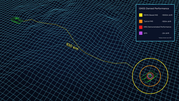
When a vehicle passes through a GNSS-denied area, its navigation system might be thrown off and report an incorrect position. Conversely, INS is inherently subject to drift — the steady accumulation of errors — and therefore must be periodically re-initialized by an external source, such as GNSS. (Photo: Safran Federal Systems)
The term “original equipment manufacturer”(OEM) is widely used, yet vaguely described. In general, an OEM product is one that a company creates and sells to be integrated into systems made by other manufacturers.
In the GNSS industry, the purchasers of OEM products typically are manufacturers of products that require precise positioning or navigation capabilities, from precision agriculture, to surveying and mapping, to UAV missions. Often, manufacturers integrate the OEM GNSS receivers with other sensors, such as inertial measurement units (IMUs) and lidar devices.
A large portion of the OEM business goes unnoticed by the end users of the equipment that utilizes OEM components. These components, such as a guidance system, are often hidden from view, due to being housed under a hood or elsewhere deep within the system.
In the following case studies, OEM products complement GNSS in air, land and marine applications. Safran Federal Systems’ INS for land vehicle navigation and Septentrio’s AIM+ anti-jamming and anti-spoofing technology tackle land and air-based defense applications, while an OxTS IMU is used in a coral reef restoration project to accurately record ship motion.
Land vehicle navigation in GNSS-denied environments
Safran Federal Systems
Ground vehicles in defense operations often navigate in challenging environments where traditional GPS signals are contested or unreliable. This includes dense urban areas, heavily forested regions, or any areas where enemies employ electronic warfare to disrupt GPS signals. Having a robust navigation system that can provide both the vehicle’s location in real time as well as its precise orientation and direction/heading is crucial for defense applications. An inertial navigation system (INS) can provide reliable position and heading data for short periods of time or distances without the aid of GPS satellite signals, allowing vehicles to stay on course and maintain awareness of their location.
Precise location and navigation capabilities are essential for mission planning, execution and coordination with other units. Inaccurate navigation can lead to mission failure, unintended engagements, or even friendly fire incidents.
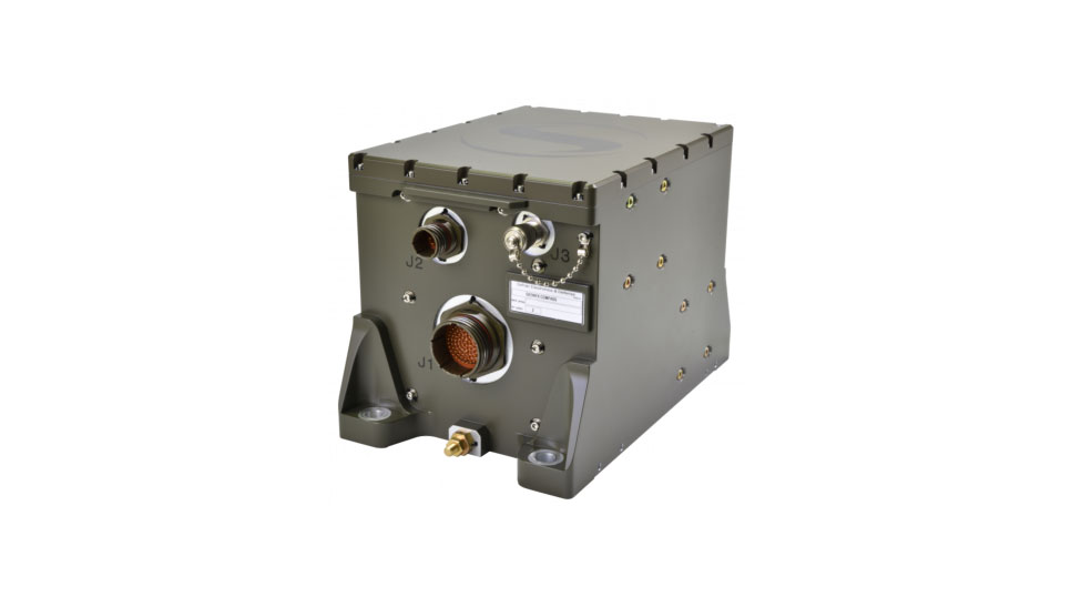
Geonyx INS
Safran’s Solution
Geonyx INS with incorporated M-Code capability
Safran has developed the Geonyx INS, which provides route guidance in GNSS-denied environments. It incorporates hemispherical resonator gyroscope (HRG) technology and does not rely on external satellite signals for navigation and heading. Instead, it uses gyroscopes to detect changes in heading and accelerometers to detect changes in acceleration, then uses those data to calculate the vehicle’s position, orientation and velocity.
The Geonyx will output coordinates of the vehicle’s current location as well as the data on its intended position to the vehicle’s battle management system (BMS). It can maintain an accuracy of a couple of meters after tens of miles of pure inertial navigation.
Geonyx is a combat-proven INS solution for ground vehicles, augmenting battle management systems. It can achieve a heading accuracy as good as 0.5 mils thanks to Safran’s HRG Crystal technology. It has quick and flexible alignment, even in GNSS-denied environments.
Safran is upgrading the Geonyx to incorporate M-Code capability. This enhancement offers a fully integrated solution to tackle the challenges of GPS-denied or spoofing environments, ensuring robust and reliable navigation even in the most demanding conditions.
JammerTest in Bleik, Andøya, Norway. (Photo: David Jensen)
Resilient GNSS receiver
Septentrio
Around the world, there is an increasing demand for better resilience in positioning, navigation, and timing (PNT) systems. U.S. President Joe Biden has signed an executive order to enhance national resilience through PNT services. Geo-political tensions require a higher level of security for operations in areas of navigational warfare (NAVWAR) under contested GNSS conditions.
In countries such as Finland, companies are seeking reliable receivers that can be connected in a network to identify sources of malicious interference. In numerous GNSS applications, such as reference networks, UAV surveillance, delivery and timing synchronization, the repercussions of PNT degradation or loss can be significant.
Septentrio’s Solution
Septentrio took part in the JammerTest 2023 event organized by the Norwegian government on the remote island of Andøya, where live interference testing was conducted in a controlled environment.
While most of these test events are classified and their results cannot be shared publicly, the JammerTest represents one of the first public events of its kind where the sharing of results is encouraged.
After five days of intensive testing in Norway, Septentrio’s AIM+ anti-jamming and anti-spoofing technology proved to work well under live interference conditions. Test results revealed that under real interference, receiver technology plays a key role, while antenna technology plays a supporting role. By testing the receiver under various types of spoofing attacks, it was shown that the best spoofing protection lies in having multiple anti-spoofing mechanisms working together.
Detecting and Mitigating GNSS Jamming
This test used a “cigarette lighter” jammer, which is commonly available for purchase online. It emits signals with power between 10 dBm and 15 dBm and can disrupt GPS L1 and L2 signals. Other jamming tests involved using jammers with signals 10 million times more powerful than GNSS signals.
Over one day of intensive jamming tests, receivers with integrated AIM+ demonstrated 99.5% positioning availability under various forms of jamming from simple continuous narrow-band interference to the most complex wide-band transmissions.
The Magic is in the Receiver
For mission-critical applications, an anti-jam antenna can help achieve maximum resilience against RF interference. During the JammerTest, three receivers were tested under heavy multi-frequency wideband jamming in combination with antennas of varying sophistication. A receiver with a standard wideband helical antenna that did not have AIM+ anti-jamming technology immediately lost tracking of satellite signals during jamming. A receiver with the same antenna, but with AIM+, continued to track signals and deliver positioning. A receiver with AIM+ coupled with an anti-jam antenna displayed that the drop in signal quality is slightly less than with a standard antenna and the receiver continued to track signals and to deliver positioning.
Tests with various anti-jam antennas showed an interference reduction of about 10 dB. While AIM+ plays a role in positioning availability under jamming, an antenna plays a supporting role and can improve the chances of getting positioning in cases where the jamming is still slightly stronger than the ability of the receiver to mitigate it. While anti-jam antennas can be effective in countering wide-band “white-noise” jamming, they are less effective for other types of jamming.
Accurate and available PNT is key to successful industrial or critical operations in challenging environments. By regularly participating in live events such as the JammerTest, Septentrio anti-jamming and anti-spoofing technology is continuously being tested and improved to withstand the latest interference attacks. This technology also has been confirmed to be effective by users out in the field, who are using Septentrio receivers in places of malicious interference, such as near contested borders.
The Reef Restoration and Adaptation Program (RRAP) is an effort to help a significant ecosystem such as the Great Barrier Reef (GBR) survive climate change. Through its Cooling and Shading sub-program, RRAP’s goal is to determine whether localized cloud brightening — a technique that involves spraying droplets of sea salt into clouds to reflect sunlight and cool Earth — and/or fogging could be a temporary solution to alleviate stress on parts of the GBR during hot summer conditions, which might lead to bleaching.
The Ordnance Survey team was tasked with consistently creating precisely georeferenced point clouds that could be utilized for identifying and classifying features. The GBR is a significant source of biogenic volatile organic compounds (BVOCs), which are likely to be impacted by ocean warming in potential climate change scenarios. In turn, these BVOC emissions can influence Earth’s radiation budget by contributing to the creation of secondary organic aerosols and cloud condensation nuclei, ultimately leading to cooling.
Southern Cross University, an RRAP partner, sought an accurate method to record ship motion for this project. The team needed to measure various parameters such as velocity, acceleration, pitch/roll, angle rate, and ship heading. They approached Industrial Measurement Solutions (IMS) and OxTS to assist them in addressing this challenge. To achieve this accurately, they needed to integrate the measurements from their existing sonic anemometer, which records three-dimensional wind velocity, with the measurements from an IMU.
OxTS Takes the Challenge
Correcting wind speed for platform motion requires two high-resolution sensors to record data simultaneously: a sonic anemometer that records three-dimensional wind velocity, and an IMU that records the movement of the platform/ship. The sonic anemometer and the IMU are two very sensitive sensors, and many of the technology challenges the team faced involved setting them up correctly and getting them to work seamlessly together.
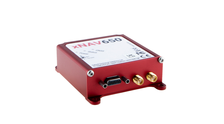
Once the project team realized that they needed an IMU to measure the ship/platform motion, one of their collaborators at the time, Airborne Research Australia (ARA), suggested an OxTS xNAV650.
After they had defined the project requirements, Southern Cross University contacted IMS who helped them navigate the commercial process.
xNAV650 is a miniature INS that uses survey-grade dual-frequency GNSS receivers and custom MEMS IMU for centimeter-level position accuracy, precise orientation and true heading. It logs the navigation data on internal storage for downloading and viewing post-mission. It can be used in many applications, such as corridor mapping and precision agriculture.
The xNAV650’s IMU allowed Southern Cross University to accurately measure the motion of the ship. The IMU was configured to “displace output” to the location of the 3D wind measurement instrument — the sonic anemometer. This allowed the project team to record the movement of the instrument directly, thus avoiding any additional complicated processing steps. Additionally, the IMU was configured to output a 1 pulse per second (PPS) signal via serial connection. This allowed the project team to connect the IMU to the sonic anemometer’s data logger to sync the time between the two instruments. This was vital on such a rapidly moving platform.
Once installed, the xNAV650 device was able to measure ship motion accurately and at high time resolution
(100 Hz), which was complementary to the team’s wind velocity and BVOC measurements. The PPS output option allowed for simultaneous measurement/recording, which would have otherwise needed to be corrected in post-calibration and would likely not have been as accurate.
“We managed to accurately record ship motion for the entire length of our second voyage,” said Liz Deschaseaux, RRAP’s research fellow on BVOC emissions. “The reliability and accuracy of the xNAV650 has had a real impact on our ability to collect meaningful data.”
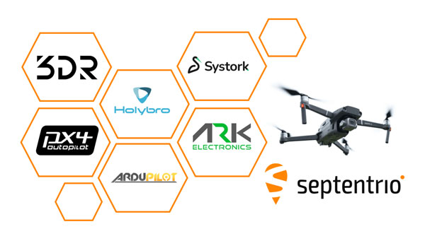
Septentrio is closely working with several UAV solutions providers including 3DR, Holybro, ARK Electronics and Systork, resulting in various new products that allow for easier prototyping or integration of the Septentrio mosaic GNSS receiver into UAVs.
mosaic is a compact triple-frequency receiver leveraging signals from all available GNSS constellations to offer the highest degree of positioning availability, even under challenging conditions. Built-in anti-jamming and anti-spoofing technology protects mosaic against intentional or unintentional interference. A high level of positioning reliability is also required by UAVs, which operate in challenging environments such as around high structures, under foliage or in places of possible RF interference. In addition to collaborations with hardware integrators, Septentrio works closely with the open-source autopilot community including PX4 and Ardupilot, which aims to facilitate a smooth integration process for end-users.
The recently available products, which are designed to bring reliable high-accuracy positioning to UAVs, include Holybro H-RTK mosaic-H (dual antenna heading), 3DR mosaic-X5 CAN GPS, Systork Linnet mosaic-X5 and ARK mosaic-x5 GPS. These products offer UAV-centered features such as magnetometer, barometer and UAV CAN communication. The integrated mosaic module receives signals from all GNSS constellations and outputs centimeter-level RTK positioning as well as full GNSS carrier raw data
Dual antenna operation is also supported with mosaic-H for heading and pitch or heading and roll orientation with sub-degree accuracy. Its anti-interference technology AIM+ is designed to protect the system from malicious jamming and spoofing attacks and reduces the risk of self-interference which occurs when nearby electronics like cameras and servos accidentally emit radio signals that interfere with GPS/GNSS.
A roundup of recent products in the GNSS and inertial positioning industry from the March 2024 issue of GPS World magazine.
SURVEYING & MAPPING
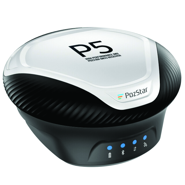
GNSS Receiver Supports tilted measurement
PozStar P5 is a high-precision GNSS receiver. It is powered by a 1,408-channel multi-band GNSS receiver designed to improve surveying in the field. It is equipped with Bluetooth, WiFi and UHF radio. The inertial measuring unit (IMU) supports tilted measurement, which allows users to obtain quick initialization and accurate measurements with an inclination of up to 60°.
The receiver comes with radio connector options used in a frequency range of 410 MHz to 470 MHz and a 5-pin serial port, which allows for external radio system connectivity and NMEA data output. It is also weatherproof, rated IP67.
PozStar P5 can collect control and surveying data for RTK equipment to perform surveying, map input and drawing operations. The receiver can be used with PozPad, an Android-based RTK field software.
PozStar, pozstar.com
Lidar System Designed for aerial surveying
The TrueView 540 lidar system integrates lidar technology with LP360 3D point cloud processing software to enhance survey-grade lidar applications.
The system is designed to provide enhanced data density, accuracy, and precision for aerial surveying. It combines lidar, an accurate positioning and orientation system and a full-frame industrial camera in a compact, lightweight package. It is suitable for a variety of UAVs, including the DJI Matrice 350.
The TrueView 540 features high-precision lidar technology comparable to high-end industry-standard payloads in terms of range, density and accuracy. It will be made available through GeoCue and its authorized distributors. GeoCue, geocue.com
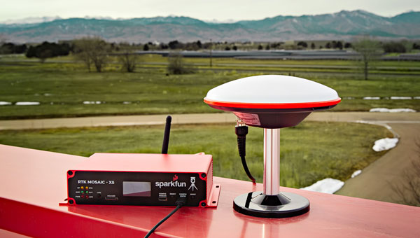
GNSS Solution Combined with Septentrio’s mosaic-X5 module
The SparkFun real-time kinematics (RTK) mosaic-X5 uses the multi-constellation, multi-frequency capabilities of the Septentrio mosaic-X5 module, which aims to improve accuracy and reliability in a variety of position applications.
The RTK mosaic-X5 is a 448-channel receiver that supports all four Global Navigation Satellite Systems (GNSS) — GPS, GLONASS, BeiDou and Galileo — and one of the two regional ones, NavIC. It can function as both an RTK base and rover, which allows users to achieve horizontal positioning accuracy down to 6 mm and updates at a rate of 100 Hz.
The device incorporates the Espressif ESP32-WROVER processor, which allows for high-speed processing and a variety of connectivity options. The ESP32 provides the device with USB-C, Ethernet-over-USB and an Ethernet to WiFi Bridge mode to ensure seamless integration into any project setup.
The device also has power flexibility, including USB-C, Power-over-Ethernet, and external DC sources, along with data logging in multiple formats such as RINEX and NMEA. Housed in a custom-designed aluminum case, the RTK mosaic-X5 features a comprehensive web server interface to simplify configuration and monitoring. SparkFun Electronics, sparkfun.com
Hybrid Mobile Mapping Solution Combines mobile scanning with a stationary mode
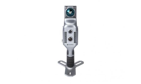
The X70GO SLAM laser scanner is designed for fast and efficient large-area surveys. It combines mobile scanning with a stationary mode to scan with high resolution to enhance overall surveying capabilities.
X70GO is a real-time 3D model reconstruction device that integrates an inertial navigation module, high-performance computer and storage system. It is equipped with a 360° rotating head, which, combined with the SLAM algorithm, can generate high-precision point cloud data. The built-in 512GB memory disk stores survey results and the dismountable handle has a 1.5-hour battery life.
A 12MP RGB camera offers texture information, while a visual camera aims to enhance the real-time preview with the GOapp. Mapping results can be generated immediately inside the scanner. Users can then color the points and improve their accuracy during post-processing with GOpost software.
The system comes with a hybrid scanning capability. The X-Whizz mode combines the advantages of SLAM mode with the resolution of a static scan, which eliminates the need for multiple scan stations. Users can move around the scene to collect the entire 3D point cloud without time-consuming cloud-to-cloud alignment.
The technology incorporated in the new scanner is designed to provide extended range, a higher number of points per second and advanced onboard processing algorithms. The SLAM laser scanner is well-suited for challenging environments and can be used in a variety of applications, including BIM, industrial sites, real estate, heritage preservation, tunnels and mining.
Users can add an RTK module to set a point cloud in a global coordinate system. This can support adding GNSS information to that from lidar and the inertial measurement unit (IMU) in the SLAM algorithm. In situations with limited GPS connectivity – such as indoors or in challenging environments – the system will rely on lidar and the IMU for positioning purposes. Stonex, stonex.it
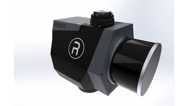
Remote Sensing Payload Integrates with UAVs and other platforms
The RESEPI lidar Gen-II remote sensing payload instrument comes in three modes: aerial mode for comprehensive airborne data collection, mobile mode for dynamic vehicular data collection and a versatile handheld/backpack that aims to provide portability and ease of use for ground personnel.
The RESEPI lidar Gen-II has a 175% increase in computing power, designed to speed up processing and enhance efficiency during complex tasks. Its memory capacity has been increased by 700%, which allows for extensive data handling and improved system performance. The system’s 50% increase in storage capacity aims to facilitate longer durations of data collection without frequent offloads.
The Gen-II features seamless integration capabilities with UAVs and other platforms. The system’s sensor-agnostic design allows for external sensors to be easily integrated, including lidar and cameras. It also can compute point clouds, trajectories and solutions in real-time, which is critical in time-sensitive missions. The system can be used in a variety of applications including mapping, inspection, autonomous vehicles, navigation and robotics. Inertial Labs, inertiallabs.com
Mapping Software With upgraded cloud capabilities
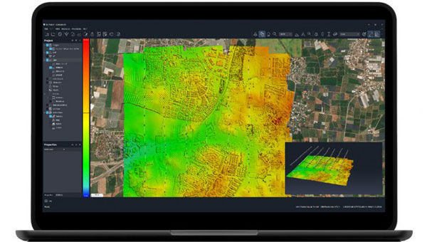
The Correlator3D mapping software now has upgraded cloud capabilities. With its distributed processing capabilities, Correlator3D allows users to scale their processing to match individual operational needs.
With the upgrade, Correlator3D can process large mapping projects and deliver results from UAV, aircraft and satellite imagery. It features a software package – a patented, end-to-end photogrammetry solution — designed to generate high-quality geospatial data from a variety of sources, including satellite and aerial imagery and UAVs. The upgrade aims to improve the technology’s performance in diverse cloud scenarios.
Correlator3D is designed to provide aerial triangulation (AT) and generate dense digital surface models (DSM), precise digital terrain models (DTM), point clouds, orthomosaics, 3D models and vectorized 3D features. By using GPU technology and multi-core CPUs, Correlator3D offers enhanced processing speed to support the rapid production of large datasets. SimActive, simactive.com
MOBILE
Handheld GNSS Data Collector Ideal for construction surveying
TDC6 is a handheld GNSS data collector designed for high-performance construction surveying. The device allows contractors to work with more complex data sets more effectively in the field, connect to the office for on-the-spot approvals, and quickly communicate changes to field crews.
The small, rugged device offers integrated Wi-Fi and Bluetooth, built-in cameras and 5G compatibility in a lightweight, shock-, dust- and water-resistant package. The device integrates seamlessly with Trimble data collection applications, including Trimble TerraFlex GIS software and Trimble Access survey field software, as well as third-party apps such as Esri ArcGIS Field Maps. Trimble Geospatial, geospatial.trimble.com
Military-Grade Antennas Designed for mission-critical applications
This advanced military-grade antenna product line includes ruggedized GPS, manpack omni and vehicle omni antennas. The products are designed for mission-critical applications such as vehicle navigation, personnel communications, vehicle communications, electronic warfare, and jamming.
The antennas meet MIL-STD-810 to offer durability while adhering to strict quality standards. The antennas also are compliant with the Trade Agreements Act (TAA), which makes them suitable for government and defense applications.
Built to withstand tough conditions, these antennas feature heavy-duty construction and a rugged design for long-lasting performance in challenging environments. They are designed to perform in extreme weather conditions and on rough terrains.
Its robust construction and NATO/U.S. standard mounting options aim to simplify integration into various setups during critical operations. Fairview Microwave, fairviewmicrowave.com
Trimble SiteVision Software 5.0. (Image: Trimble)
Outdoor Augmented Reality System With 3D scanning capabilities
SiteVision Software 5.0 is a high-accuracy outdoor augmented reality system, now with a 3D scan tool. The new 3D scan tool allows users to use lidar sensors available on some Apple Pro devices. The Trimble DA2 GNSS receiver is designed to capture point clouds efficiently and accurately with a single handheld solution.
Users can visualize 3D scan data directly in the field with SiteVision’s augmented reality view. The software allows users to create as-builts of the job site on the go, measure and plan resource allocation, reduce scan times, supplement UAV data and more by combining scanning and precision in a mobile solution. The product aims to facilitate practical and accessible field-to-office workflows for surveyors, contractors and engineers.
Trimble Geospatial, geospatial.trimble.com
OEM
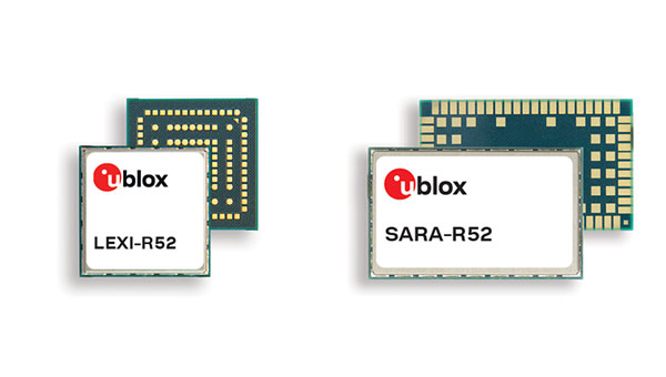
Two LTE Modules With integrated GNSS
The LTE-M cellular module series, the SARA-R52 and LEXI-R52, are designed to meet the needs of industrial applications requiring both positioning and wireless communication capabilities. Based on the u-blox UBX-R52 cellular chip, these modules are designed for a variety of internet of things (IoT) use cases, including both fixed and mobile applications.
The UBX-R52 chip is designed to simplify product design by reducing the need for additional components. It includes SpotNow, a positioning function developed by u-blox, which aims to provide location data with an accuracy of up to 10 m within a few seconds. This function is targeted at applications requiring occasional tracking, such as waste management, personal trackers and industrial machinery.
The chip’s uCPU feature allows the execution of custom software directly on the chip and eliminates the necessity for an external microcontroller unit (MCU). The smart connection manager (uSCM) is a feature designed to manage connectivity automatically, focusing on optimizing performance or minimizing power consumption under varying connection conditions.
The R52 series introduces the SARA-R520M10 combo module, which is equipped with an integrated u-blox M10 GNSS receiver. This module is designed to provide simultaneous GNSS and cellular connectivity, supporting applications that require continuous or periodic tracking with features such as low power consumption, improved time-to-first-fix (TTFF) and increased RF sensitivity.
Unlike many LTE-M modules that typically offer an RF output power of 20-21 dBm, the new R52 series modules offer a higher output power of 23 dBm to improve connectivity in difficult coverage areas. The LEXI-R52 offers the same functionalities as the SARA-R52 but comes in a smaller form factor, making it ideal for applications with space constraints, such as wearable technology.
These additions to u-blox’s LTE-M module portfolio are designed to address the integration of GNSS and wireless communication in industrial IoT applications, offering solutions for a range of use cases that require robust connectivity. u-blox,u-blox.com
UAV
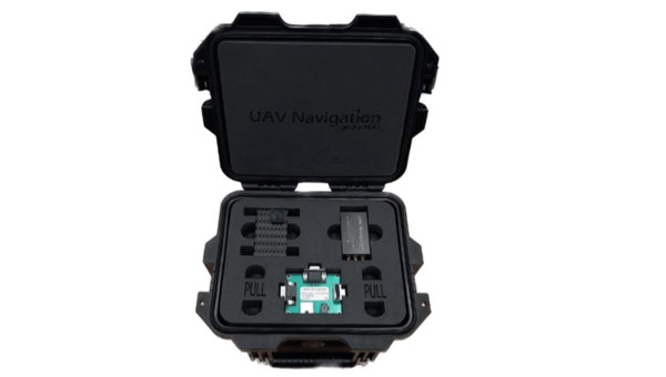
GNSS-Denied Navigation Kit For challenging environments
This GNSS-denied navigation kit is designed to offer navigation capabilities in challenging environments. It combines UAV Navigation’s attitude and heading reference system (AHRS), the POLAR-300, with its Visual Navigation System, the VNS01, to offer advanced dead reckoning navigation capabilities with minimal drift.
The technology has error rates as low as 0% to 1% over covered distances. This is made possible by the kit’s visual-based technology, which allows for precise attitude and position estimation to stabilize flights in challenging conditions. The kit is equipped with advanced algorithms that can detect and counter sophisticated spoofing and jamming techniques to offer reliable and secure navigation, even in the face of potential signal disruptions. The kit can be used in both civil and defense sectors.
UAV Navigation-Grupo Oesía, uavnavigation.com
Lidar UAV Solution Offers immediate access to terrain information
The lidar UAV mapping solution combines the WingtraOne GEN II UAV with a newly developed lidar sensor. This integration aims to advance UAV lidar efficiency, increase accuracy and simplify integration.
The solution incorporates a Hesai scanner, Inertial Labs IMU and NovAtel GNSS receiver designed to optimize data acquisition and reduce the need for post-processing strip alignment. This advancement offers immediate access to precise terrain information following each flight and enhances the efficiency of mapping and photogrammetric analysis in various sectors.
One of the key features of the lidar system is its reduced field time, with no calibration needed and a one-minute initialization process. The Wingtra lidar application and the system’s automated features offer a streamlined data capture process, which makes it accessible even to those new to lidar technology.
The solution offers a vertical accuracy of 3 cm from a 60 m flight height, with leading point density in its class. The WingtraOne GEN II’s design and automated flight patterns offer consistent results across different pilots. Wingtra, wingtra.com
MACHINE CONTROL
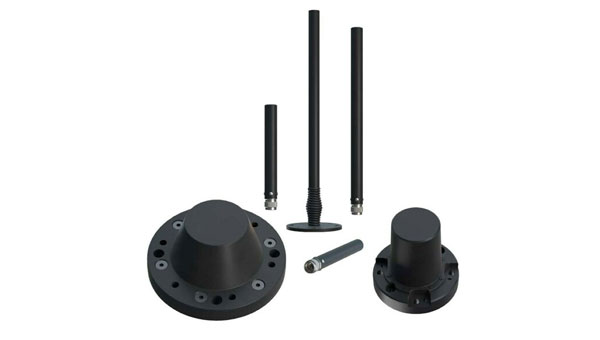
GNSS Smart Antenna Designed for industrial environments
AntaRx-Si3 is a GNSS/INS smart antenna housed in an ultra-rugged enclosure, designed for straightforward installation on machinery such as agricultural robots. It combines Septentrio’s centimeter-level GNSS positioning with an inertial measurement unit (IMU) within the same enclosure as the GNSS antenna, which uses FUSE+ technology.
The AntaRx-Si3 is designed for challenging industrial environments where GNSS signals are at risk of obstruction, such as under heavy foliage. The antenna’s exterior is crafted from impact-resistant polycarbonate with an IP69K rating and can withstand significant shocks, vibrations, and harsh environmental conditions.
It uses Septentrio’s GNSS+ algorithms to offer advanced multipath mitigation to operate in environments where satellite signals could be reflected off surrounding machinery or structures, such as silos. The antenna delivers high update rates and low latency positioning, which are crucial for the control loops of autonomous movements or rotations. Septentrio, septentrio.com
3D Machine Control Software Suitable for construction sites
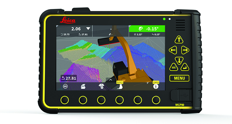
The Leica MC1 software platform is designed to guide and automate machine control solutions.
Leica MC1 machine control software continues to evolve toward achieving a smart digital reality, with features such as Modify Models and surface logging. It compares the design model to the actual position of the machine’s cutting edge, such as the bucket or blade edge. The technology aims to assist operators in positioning machinery to achieve the planned design while allowing for a live digital representation of the progress. The software automatically controls the position of the machine’s cutting edge.
It is carried by the rugged hardware platform, the Leica MCP80 panel and MDS Series docking station, offering an interchangeable panel between machines on a job site. The MC1 platform is supported by the cloud-based Leica ConX productivity platform to offer more efficient management of heavy construction projects.
Leica Geosystems, part of Hexagon, leica-geosystems.com