STMicroelectronics has released the ASM330LHB automotive-qualified MEMS inertial-sensing module, which provides accurate measurements for a wide variety of vehicle functions. With the dedicated software provided, ASM330LHB also addresses functional-safety applications up to ASIL B1.
ASM330LHB contains a 3-axis digital accelerometer and 3-axis digital gyroscope that provide a six-channel synchronized output. The module’s high-accuracy inertial measurements are used to improve the precise positioning of a vehicle.
The accelerometer and gyroscope maintain high stability over time and temperature and have very low noise for an overall bias instability of 3°/hour. Specified over the extended temperature range, -40°C to 105°C, the ASM330LHB has multiple operating modes that let designers optimize the data-update rate and power consumption.
ASM330LHB can support advanced driver assistance systems or vehicle-to-everything communication, as well as help stabilize sensing systems such as radar, lidar and cameras, and assist semi-automated driving applications up to L2+. Additionally, ASM330LHB can be used to enable a variety of functionalities in the body of a vehicle.
ASM330LHB was developed with the automotive functional-safety standard ISO 26262 — the ASIL B compatible software library has been certified independently by TÜV SÜD. By implementing dedicated safety mechanisms, including data integrity and accuracy, the library ensures compliance with ASIL B automotive systems.
With the companion software engine, the ASM330LHB supports the growing adoption of automotive systems that require safety integrity up to level B. The combination of two ASM330LHB sensor modules for fail-safe redundancy delivers resilient contextual data for driver-assistance applications such as lane centering, emergency braking, cruise assistance and semi-automated driving.
ASM330LHB is AEC-Q100 qualified and in production now in a 2.5 mm x 3.0 mm 14-lead VFLGA package.
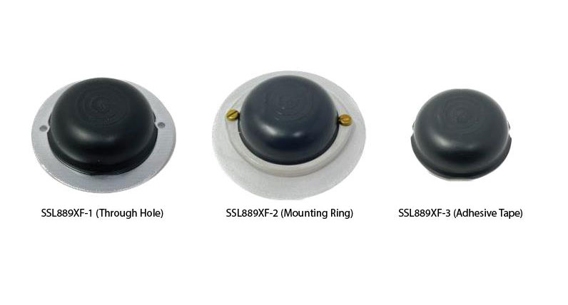
Tallysman Wireless has added the SSL889XF dual-band GNSS antenna to its line of GNSS products.
The SSL889XF employs Tallysman’s Accutenna technology providing GPS, QZSS L1/L2, GLONASS G1/G2/G3, Galileo E1/E5b, and BeiDou B1/B2b coverage. The SSL889XF antenna is designed for precision dual-frequency positioning where a light weight and a low profile are important.
The SSL889XF antenna element is 48 mm in diameter and 20 mm tall and weighs ~50 g. It has a tight average phase center variation of less than 10 mm for all frequencies and overall azimuths and elevation angles.
The SSL889XF is available in three versions. Model SSL889XF-1 has an integrated 61 mm ground plane and two mounting holes. Model SSL889XF-2 has a mounting collar, and model SSL889XF-3 is the antenna only and is attached using adhesive tape.
All models have a female MCX connector.
The SSL889XF antenna also supports Tallysman’s eXtended Filtering (XF) technology.
Comnav Technology has released the U702 datalink module, an RX/TX data link module that supports the LoRa modulation technique.
Its compact, surface-mounted design and robust electromagnetic compatibility enables easy integration into GNSS systems such as robotic lawn mowers.
With the LoRa modulation technique, the U702 has low power consumption, reception power of 0.025 w, and a working distance up to 1.5 km. It also enhances the ability to protect GNSS systems against various interference — making it possible to have high reception sensitivity, a low error rate, and high reliable data transmission even in harsh environments.
Drone Safety Day (DSD) is returning for its fifth consecutive year on April 29. The annual campaign, designed by the Federal Aviation Administration (FAA), is dedicated to educating the drone community on the importance of flying safely.
The event will highlight the societal, economic, and safety benefits of safe drone operations. DSD will feature in-person, virtual and hybrid events in areas such as education, economics, equity, environment and emergencies.
DSD provides opportunities for businesses, schools and organizations to share how they use drones, as well as kick off new safety initiatives. The 2023 campaign encourages drone pilots and recreational flyers to “Fly RIGHT” by focusing on five safety elements:
Register your drone
Interact with others
Gain knowledge
Have a safety plan
TRUST and Train
A full list of events and registration can be found on the FAA website.
The same 91 signers also sent an identical letter to President Biden.
April 24, 2023
Dear Senators and Members of Congress:
Last year, many of the undersigned wrote in reflection of the unprecedented opposition to the Federal Communications Commission’s (FCC’s) Ligado Order(1) across the vast federal and commercial user base of Global Positioning System (GPS), satellite communications and weather forecasting services. Three years after adoption of the Order, as eight petitions for reconsideration remain pending, (2) we again urge you to work together with the FCC to stay and ultimately set aside the Order. (3) Critically, this is now necessitated by the crucial, previously unavailable information that was produced at the direction of Congress: the independent technical review undertaken by the National Academies of Sciences, Engineering, and Medicine (NAS) (4) analyzing the potential interference issues related to the Ligado Order.
We greatly appreciate your administration’s opposition to the Ligado Order and commitment that the National Telecommunications and Information Administration (NTIA), on behalf of the executive branch, will continue to actively pursue its petition for reconsideration of the Order. (5) As you know, the pending petitions for reconsideration convincingly demonstrate that the Ligado Order is legally and factually deficient. In the pending petitions, parties showed that the Ligado Order is fundamentally flawed, incompatible with the FCC’s rules and inadequate in protecting incumbent services from the harmful interference from Ligado’s proposed operations. This substantial documentation, among many other concerns from federal and commercial users, resulted in Congress enacting bipartisan legislation in consecutive years after the FCC’s adoption of the Ligado Order, mandating NAS’s independent technical review and requiring the Department of Defense (DoD) to brief federal representatives across the government “at the highest level of classification” on the potential for widespread harm from Ligado’s proposed terrestrial operations. (6) On this basis alone, the FCC should stay the Order in an acknowledgement that it clearly did not account for the full, real-world risk of harm associated with a nationwide terrestrial deployment in the L-band.
While the pending petitions have a strong likelihood of success on their own merits, the FCC’s rules and the public interest now require the FCC to reconsider the Order in response to the extensive analysis in the NAS Report. (7) This new, previously unavailable information presented in the Congressionally-mandated independent technical review confirms that Ligado’s proposed terrestrial operations would cause harmful interference (8) at significant ranges to incumbent L-band services across a broad range of deployment scenarios. This is consistent with the well-supported and robustly documented analyses and determinations of the federal government, (9) including fourteen federal agencies and departments, (10) and commercial parties (11) alike. Importantly, as concisely stated by DoD and detailed in the NAS Report, “[t]he terrestrial network authorized by [the Ligado Order] will create unacceptable harmful interference for DoD missions. The mitigation techniques and other regulatory provision [sic] in [the Ligado Order] are insufficient to protect national security missions.”(12)
The unequivocal conclusions of the NAS Report constitute the exact type of previously unavailable information that the FCC’s rules (13) dictate must be addressed on reconsideration. Indeed, NTIA stated on behalf of the executive branch that the NAS Report “offers the [FCC] an important opportunity to reconsider Ligado’s Authorization.”(14) We therefore urge you to work with the FCC to address the harm from Ligado’s proposed terrestrial network to critical GPS, satellite communications, and weather forecasting services by staying the Order, addressing the previously unavailable information contained in the NAS Report, and resolving the pending petitions for reconsideration.
Sincerely,
AccuWeather, Inc.
Aerospace Industries Association
Agricultural Retailers Association
Airborne Public Safety Association
Aircraft Electronics Association
Aircraft Owners and Pilots Association
Airlines for America
Alabama Agricultural Aviation Association
ALERT Users Group
Allied Pilots Association
Air Line Pilots Association, International
American Geophysical Union
American Meteorological Society
American Rental Association
American Road & Transportation Builders Association
American Weather and Climate Industry Association
Arizona Agricultural Aviation Association
Arkansas Agricultural Aviation Association
Associated Equipment Distributors
Association for Uncrewed Vehicle Systems International
(1) Ligado Amendment to License Modification Applications, IBFS File Nos. SES-MOD-20151231-00981, SAT-MOD-20151231-00090, and SAT-MOD-20151231-00091, Order and Authorization, 35 FCC Rcd 3772 (2020) (“Ligado Order” or “Order”).
(2) More than twenty parties in total signed petitions for reconsideration of the Ligado Order and all of these petitions remain pending before the FCC. See Petitions for Reconsideration of the National Telecommunications and Information Administration; the Air Line Pilots Association, International; the American Road & Transportation Builders Association, the American Farm Bureau Federation, and the Association of Equipment Manufacturers; the Joint Aviation Petitioners; Iridium Communications Inc., Flyht Aerospace Solutions Ltd., Aireon LLC, and Skytrac Systems Ltd.; Lockheed Martin Corporation; Trimble Inc.; and the Resilient Navigation and Timing Foundation, IB Docket Nos. 11-109 & 12-340 (all filed on or about May 22, 2020). The ten “Joint Aviation Petitioners” consist of the Aerospace Industries Association, the Aircraft Owners and Pilots Association, Airlines for America, Aviation Spectrum Resources, Inc., the Cargo Airline Association, the General Aviation Manufacturers Association, the Helicopter Association International, the International Air Transport Association, the National Air Transportation Association and the National Business Aviation Association.
(3) The Commission should also not proceed with any companion rulemakings causing harmful interference to weather forecasting and hydrology services that could result in Ligado deployments, particularly in light of the analysis and recommendations presented in the “Spectrum Pipeline Reallocation 1675–1680 MHz Engineering Study (SPRES) Program Report. See Allocation and Service Rules for the 1675-1680 MHz Band, Notice of Proposed Rulemaking, 34 FCC Rcd 3352 (2019); U.S. Department of Commerce. National Oceanic and Atmospheric Administration. National Environmental Satellite Data Information Service. Spectrum Pipeline Reallocation 1675–1680 MHz Engineering Study (SPRES) Program Report. Silver Spring, MD: NESDIS, October 2020 (public release August 2022).
(4) National Academies of Sciences, Engineering, and Medicine, Analysis of Potential Interference Issues Related to FCC Order 20-48 (2022), https://doi.org/10.17226/26611 (“NAS Report”).
(5) Letter from Gina Raimondo, Secretary of Commerce, U.S. Dept. of Commerce, to The Honorable James M. Inhofe, ranking member, U.S. Senate Committee on Armed Services (June 22, 2021) (reiterating the NTIA’s position opposing the Ligado Order).
(6) William M. (Mac) Thornberry National Defense Authorization Act (“NDAA”) for Fiscal Year 2021, Pub. L. 116-283, 134 Stat. 4074 § 1663; NDAA for Fiscal Year 2022, Pub. L. 117-81, 135 Stat. 1541 § 1613.
(7) These statements are based on the publicly available portions of the NAS committee’s work. In addition, NAS prepared a classified annex, which further details the risks of Ligado’s proposed terrestrial network and additionally warrants FCC action.
(8) The term “harmful interference” is herein used to describe the results of the NAS Report. In turn, the undersigned believe the results of the NAS Report dictate that the FCC must reach the legal conclusion that Ligado’s operations would cause harmful interference under the FCC’s rules.
(9) See, e.g., National Telecommunications and Information Administration Reply to Ligado Networks LLC’s Opposition to Petitions for Reconsideration or Clarification, IB Docket Nos. 11-109 & 12-340, at 10 n.26 (filed June 8, 2020); U.S. Department of Transportation, Global Positioning System (GPS) Adjacent Band Compatibility Assessment, Final Report (Apr. 2018) (“DOT ABC Report”),
(10) See Memorandum from Thu Luu, Executive Agent for GPS, Department of the Air Force, to IRAC Chairman (Feb. 14, 2020).
(11) See, e.g., Letter from J. David Grossman, Executive Director, GPSIA, to Marlene H. Dortch, Secretary, FCC, IB Docket Nos. 11-109 et al., at 6 (Sept. 17, 2020); Letter from Bryan N. Tramont, Counsel to Iridium Communications Inc., to Marlene H. Dortch, Secretary, Federal Communications Commission, IB Docket Nos. 11-109 et al. (Jan. 19, 2022); Update to 2016 Technical Assessment of Ligado User Terminal Interference to Iridium attached to Iridium Communications Inc. et al., Petition for Reconsideration, IB Docket Nos. 11-109 et al. ( May 22, 2020).
(12) NAS Report at 6, 73.
(13) 47 C.F.R. § 1.106(c)(2).
(14)Press Release, NTIA, NTIA Statement on National Academies of Sciences Report (Sept. 9, 2022).
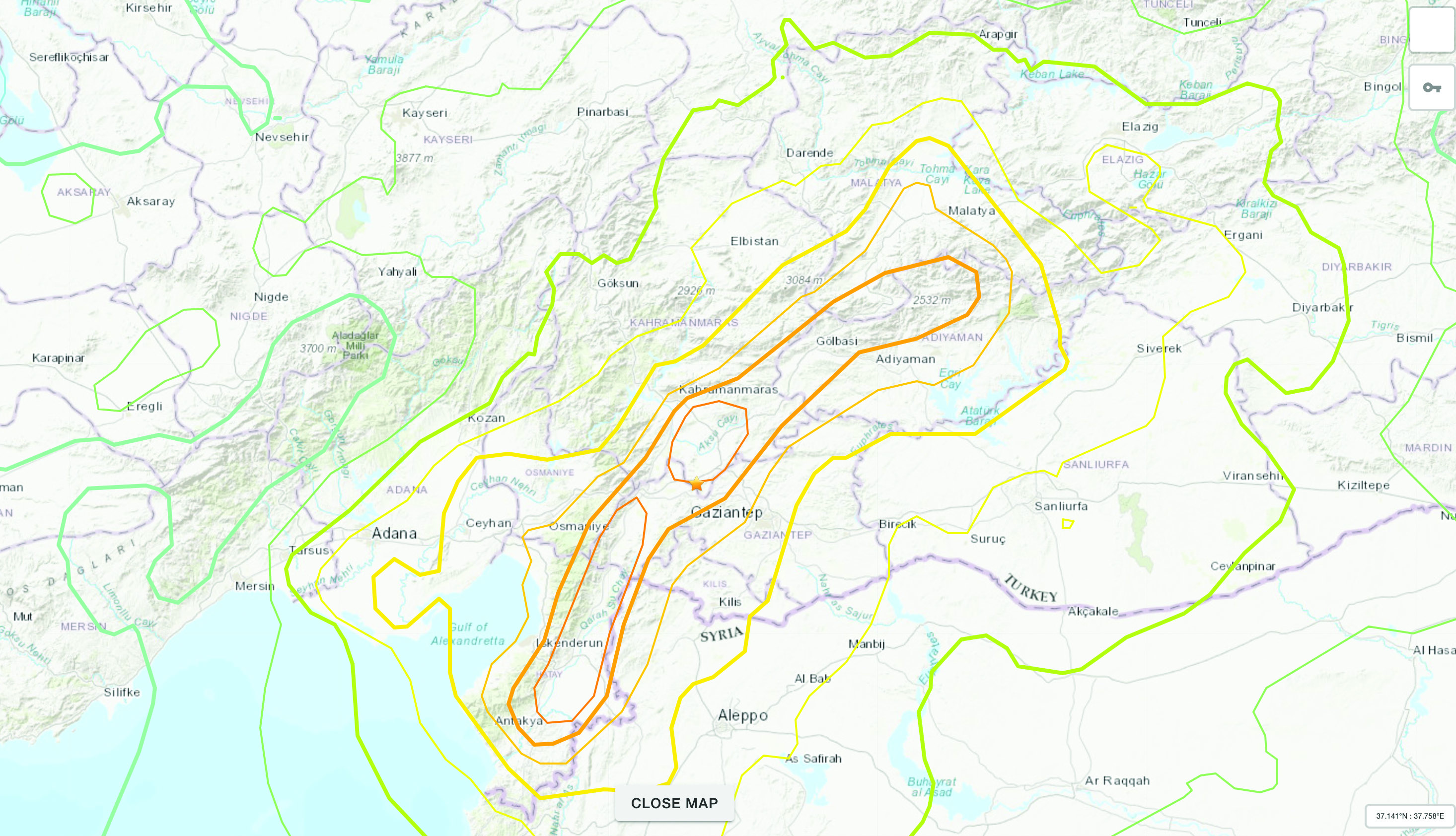
The Mw 7.8 and Mw 7.5 Kahramanmaraş Earthquake Sequence struck near Nurdağı, Türkiye, on Feb. 6. It collapsed several buildings and has claimed more than 50,000 lives. The impact of the initial earthquakes was very severe, but to make matters worse, later in February, a Mw 6.4 tremor struck near Antakya, a city near Türkiye’s border with Syria. This created further damage to infrastructure and claimed more victims.
Image: Screenshot of video from NBC News
The Specifics
The United States Geological Survey reports that the earthquake resulted from strike-slip faulting at shallow depths. The earthquake sequence displaced numerous fault segments within the East Anatolian Fault zone. Early estimates indicate about 185 miles of fault length ruptured. Parts of the North Anatolian Fault shifted 10 feet, while segments of the East Anatolian Fault slid more than 30 feet.
Historic Site Suffers
Gaziantep Castle dates back to the second millennium B.C. It has been used in many capacities throughout history, and more recently, stood as a museum for visitors to learn about its rich history. The castle was reduced to rubble in the earthquake. Other historical sites that sustained damage include the Yeni Mosque and the ancient city of Aleppo in Syria.
Image: Screenshot of CNN video
Earth Opens Up
The earthquake destroyed cities all over Türkiye and northern Syria, but they are not the only areas that suffered dramatic effects. A verdant olive grove in Tepehan, Hatay Province, Türkiye, was completely divided when the ground split, creating a 984-foot-long valley in the middle of the grove. The valley is more than 130 feet deep and has created issues for the 7,000 people that inhabit the area.
LEUVEN is a city with a bustling atmosphere full of shops, restarants and more. The culturally rich city is inhabited by more than 100,000 people — 60,000 of them being students. (Image: lavio Vallenari/iStock Unreleased/Getty Images)
Follow the cobblestone road through the narrow streets of Leuven, Belgium, and you will likely come out to the medieval-looking main square surrounded by a gothic church, lavishly architected restaurants and the breathtaking city hall, ornamented by hundreds of historical statues. Don’t let it fool you — this culturally rich city produces some of the most cutting-edge technology today, right next to the world-famous Stella Artois beer factory. In fact, Leuven was named as the European Capital of Innovation by the EU Council in 2020.
In this city is the headquarter of Septentrio, a manufacturer of high-precision GNSS positioning solutions and a fast growing company. Septentrio’s recently launched products, including the compact mosaic-X5 GNSS module and AsteRx-i3 GNSS/INS OEM board, are further fueling its growth and market share gains.
There is an intricate link between the city of Leuven, its university, and the high-tech industry that results in such a bubbling cauldron of innovation. The powerful synergy between the university and the city makes Leuven unique. Established in 1425, the Catholic University of Leuven (KU Leuven) is one of the oldest universities in Europe. It uniquely combines a very high standard of education with openness and inclusiveness.
This combination of excellence and inclusiveness is rather unique, as most top-quality universities have a more exclusive approach. While ranked as one of the top universities by Reuters, KU Leuven is accessible to students from around the world and actively collaborates with industry players in the surrounding area. At the same time, Leuven’s local government enables and supports the university with housing, student life, events, grants and more. With more than 150 nationalities living in Leuven, the city is a hotspot of diversity in terms of cultural background, experience and talent.
SEPTENTRIO headquaters is nestled near KU Leuven University — one of Europe’s top sources for talent in the areas of signal processing and advanced algorithms. (Image: Matteo Luccio)
As early as 1972, the university established the Leuven Research and Development Tech Transfer office, to valorize know-how. Since then, hundreds of spin-offs have emerged and settled in the Leuven area, including the Haasrode Research-Park, where 12,000 professionals work today and where Septentrio is situated.
Another important player tightly linking KU Leuven and the industry is the IMEC research center. IMEC is the world’s largest independent research center dedicated to semiconductor technology, housing the most advanced wafer fab equipment and employing more than 5,000 researchers. It has more than 4,000 active patents today. As the chairman of its board, I can personally vouch for IMEC as a center of excellence, with the highest standards for quality, fueled by the most talented post-graduates of KU Leuven and professionals from all around the world. For example, IMEC has recently built a new clean room, totaling 12,000 square meters, operating 24/7 to produce next-generation integrated circuit technology and nanoelectronics. Once a new idea or technology is identified, it is sometimes spun-off as a company. That’s exactly how Septentrio started 22 years ago, and it still works very closely with IMEC as a partner and a source of talent for semiconductor and hardware development.
Another key partner of Septentrio is the European Space Agency (ESA), which enables us to be at the forefront with the latest GNSS technology. From the very inception of Galileo, the European GNSS constellation, ESA has given us the opportunity to be involved as the developer of the Test User Receiver, which acquired the very first signals. Septentrio has also been providing reference receivers for the ground segment of the European Geostationary Navigation Overlay Service (EGNOS), which is Europe’s regional satellite-based augmentation system (SBAS), aimed at providing higher accuracy positioning for airplanes. Working with ESA as a strategic partner allowed us to gain the expertise and insights needed to be the first to market with many key technologies, for example the Open Service Navigation Message Authentication (OSNMA) anti-spoofing authentication on the mosaic module.
Our strategic partnership with ESA and close collaboration with the IMEC semiconductor technology hub has enabled Septentrio to produce mosaic-X5. This compact module is one of the highest performing and resilient GNSS receivers on the market. It is used in a wide array of applications, especially where the position is mission-critical. Examples include a wide variety of autonomous devices, including UAVs that benefit from mosaic’s lightweight and low-power design. The mosaic-H provides accurate heading and is used in applications such as faster set-up and directing of 5G telecom antennas
In short, Leuven offers us an exciting and innovative working environment, as we continue to push out the limits of technology to deliver better solutions to our customers.
On April 15, TrustPoint, an aerospace startup that provides GNSS products and services, launched its first satellite. The satellite, named It’s About Time, enables TrustPoint to demonstrate core technologies as it progresses towards delivering GPS-independent global time and positioning services.
“TrustPoint’s platform is the first commercially funded, purpose-built PNT microsatellite,” Patrick Shannon, CEO of TrustPoint, said. “With this mission, we are expediting the impact of commercial technologies and innovation cycles on the world of timing and navigation, arguably one of the most far reaching and critical satellite services today.”
Maverick Space Systems, a launch services provider and rideshare aggregator, supported the launch of It’s About Time on SpaceX’s Transporter-7 mission out of Vandenberg Space Force base in California. This first mission focuses on testing, calibration and optimization of TrustPoint’s microsat-compatible GNSS payload technology.
After an initial commissioning period, TrustPoint will take control of the satellite and operate it through a series of tests and demonstrations.
TrustPoint aims for its constellation to deliver secure high precision time and positioning services within the next few years. This capability will help fortify existing critical applications and enable the proliferation of nascent use cases in autonomous navigation, national security and smart infrastructure.
Qualcomm Technologies and Xiaomi have verified meter-level positioning in the Xiaomi 12T Pro powered by the Snapdragon 8+ Gen 1 mobile platform, in Germany.
Accuracy verification tests, including driving tests, were conducted by Qualcomm Technologies, Xiaomi, and Trimble in various scenarios such as open-sky rural roads and urban highways. The companies’ solutions demonstrated meter-level positioning variance at a 95% confidence level.
This level of accuracy in a commercial smartphone is enabled through Qualcomm meter-level positioning for mobile in combination with Trimble RTX correction services. When integrated with Snapdragon mobile platforms, Trimble RTX enhances the phone’s positioning capabilities.
Meter-level positioning accuracy can improve smartphone user experience in several scenarios, including mapping, driving, and other mobile applications. It enables greater accuracy when using ridesharing applications to identify pick-up locations for both driver and rider, fitness applications to track users’ movements, and in-vehicle real-time navigation applications for increased lane-level accuracy with greater map details and more accurate directions.
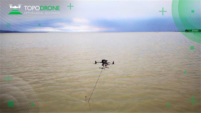
Topodrone and Rasa Surveying have partnered to advance airborne surveying approaches and accommodate coastal management and monitoring demands in the Philippines.
The approach of Rasa Surveying synchronizes current photogrammetry and lidar practices with the bathymetric data collection capabilities of Topodrone’s Aquamapper. The coupling of orthophotos, above and below waterline point clouds, and bathymetric data aims to support authorities in managing coastlines and enhance the resilience of coastal communities.
“Coastal cities in the Philippines are vulnerable to the effects of climate change and climate-related disaster events,” Maxim Baklykov, Topodrone CEO, said. “However, coastal areas are expensive and challenging to map using conventional technologies. UAV-based surveying of coastal environments allows quickly and accurately to collect shallow water data and details on the land-sea interface.”
The International Civil Aviation Organization (ICAO) has adopted international standards for Galileo and future satellite-based augmentation systems (SBAS). This is a milestone for the aviation industry, as the European Union Agency for the Space Programme (EUSPA) can now fully leverage the potential of satellite navigation services developed in Europe — in combination with GPS — to make air travel safer, more efficient, and more reliable.
Galileo will provide advanced navigation capabilities to aviation, improving the availability and reliability of services. The risk of loss or interference will be significantly reduced with a more accurate and secure signal for positioning and timing.
Additionally, the evolution to the European Geostationary Navigation Overlay Service (EGNOS) v3 will augment Galileo and enable the use of its dual-frequency bands — E1 and E5, protected for aviation use — in combination with GPS. This enhances vertical guidance to enable precision approach and landing capabilities for all equipped aircraft across Europe.
The adoption of these international standards is a result of the work done by the European Commission Directorate-General for Defence Industry and Space, in partnership with EUSPA, DG-MOVE, European Aviation Safety Industry, the European Space Agency and in coordination with the EU Member States and their ANSPs.
A couple of stories about unmanned air vehicles in the war in Ukraine and a response to the recent Open Letter by the “Future of Life Institute” with more than 200,000 signatures on advanced AI, which urged a six-month moratorium to allow the development of seemingly much needed AI regulations.
The war in Ukraine
It has been reported that Ukrainian forces were operating the commercially available Chinese Mugin 5 UAV, presumably for surveillance of Russian forces inside Russian-occupied territory. The Mugin 5 can be bought commercially for $10-15,000 and is manufactured by Mugin, which is based in the port city of Xiamen, on China’s eastern coast. In a previous statement posted on the company’s website on March 2, Mugin Limited said that it “condemns” the use of its products during warfare and that it ceased selling products to Russia or Ukraine at the start of the war. However, Russian forces claimed in January 2023 that it had actually shot down one of these Chinese-made UAVs being flown by Ukrainian forces over their territory.
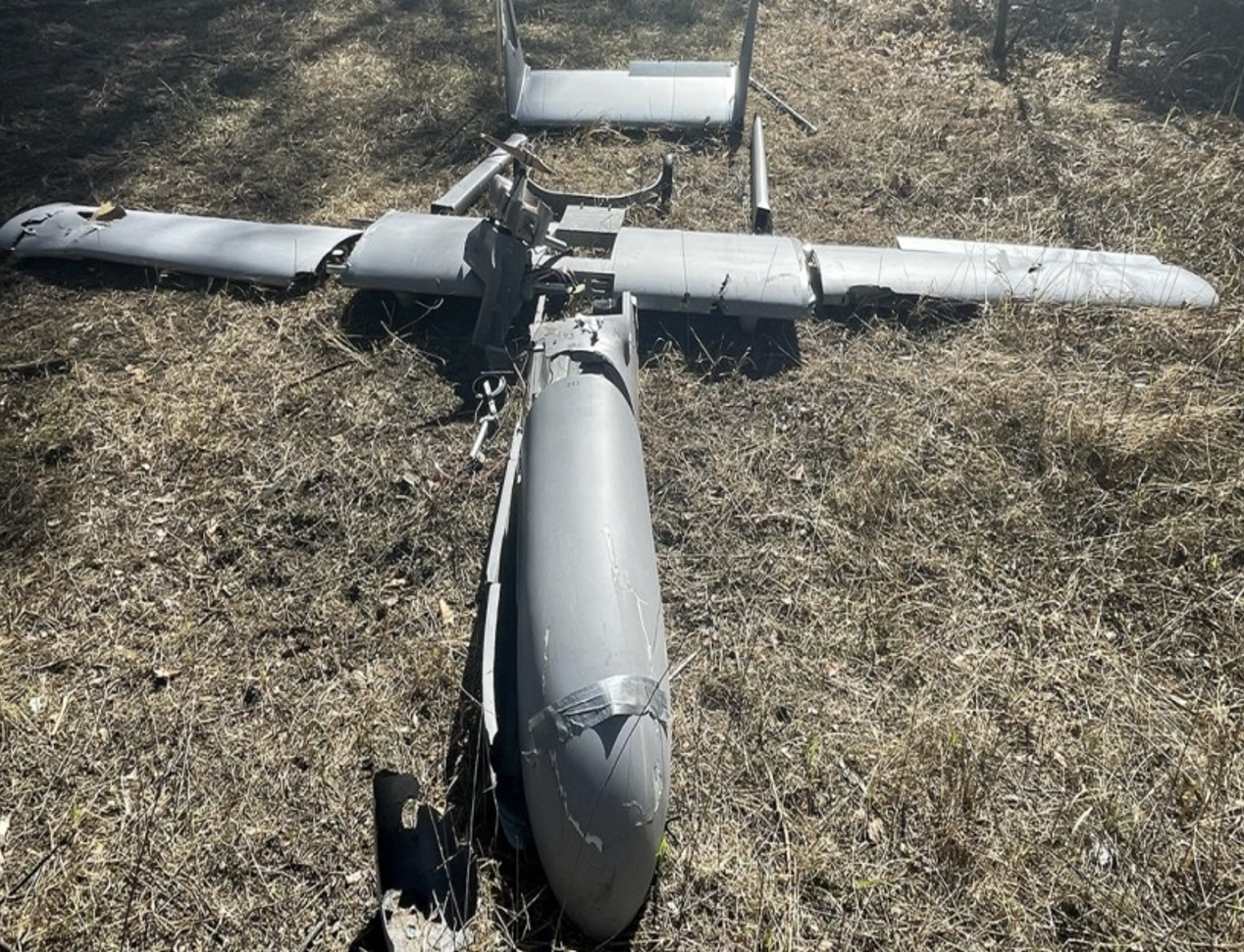
Then, just this week, Ukrainian forces apparently were able to track a low level, slow-moving air vehicle coming at them from Russian occupied territory. After some time, they were able to intercept the UAV, which carried a flashing navigation light, from the ground, and were able to bring it down using small arms. The remains of the crashed UAV were found in a clearing in the forest; a single 44 lb bomb was removed from the wreckage and safely exploded by the Ukrainian team.
Weaponized Mugin 5 following crash in Ukraine forest. (Image: Screenshot from video from Kanal13 Youtube)
Somewhat worse for wear, the Mugin 5 UAV appears to have been held together in places by duct tape and other patches. Is it possible that having shot down a Ukrainian surveillance UAV the Russians recovered these remains and crudely restored the unit to flying and navigating capability, then sent it back to Ukraine owners carrying a bomb? Anything is possible in this conflict.
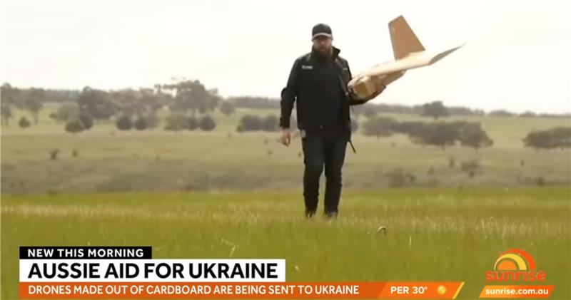
Staying with this conflict and the use of UAVs by both sides, its seems that Australia has come up with a low-cost surveillance UAV that is virtually undetectable and it’s proving quite popular with the Ukrainians. Most defensive detection involves some form of radar scanning, which relies on radar returns bouncing off a flying target. The Australian company SYPAC in Melbourne has developed the Corvo Precision Payload Delivery System (PPDS). It is a wax-coated cardboard UAV, held together with elastic bands and glue, but carrying sophisticated guidance and control electronics.
(Image: Screenshot of video posted by 7 News Australia)
SYPAQ has developed the CORVO UAV under an AU $1.1 m government contract with the objective of creating a low-cost, disposable UAV to deliver urgent needs — such as medical supplies or to resupply small arms ammunition to the Australian military. CORVO is autonomous once launched, using GNSS guidance, or dead reckoning if GNSS signal is lost or jammed. Apparently, hundreds of these disposable UAVs have already been shipped to Ukraine.
While a surveillance role was originally envisaged in Ukraine, it is reported that, “They have been very good at inflicting lots of damage on the enemy,” according to Ukraine’s ambassador to Australia. So, CORVO UAVs may well have already been weaponized.
Open Letter on AI development
Following a recent open letter supported by Elon Musk and Steve Wozniak that proposes a six-month halt on advanced AI development, I was recently approached on behalf of Professor Ioannis Pitas, director of the Artificial Intelligence and Information Analysis (AIIA) lab at the Aristotle University of Thessaloniki (AUTH) and management board chair of the AI Doctoral Academy (AIDA) with somewhat different views.
In order to further the on-going discussion, I thought it would be appropriate to give some space to an alternate view on AI development. So here are some paraphrased comments approved by Pitas:
Could AI research be stopped even for a short time? It is doubtful. Further AI progress is necessary for us to transition from an information society to a knowledge society.
Maybe we have reached the limits of AI research carried out primarily by Big Tech, which appears to treat powerful AI systems as black boxes whose functionality may be poorly understood.
It seems that the open letter reflects welcome and genuine concerns on social and financial risk management. Are expensive lawsuits in an unregulated and unlegislated environment inevitable as a consequence of ill-advised AI pronouncements?
However, it is doubtful whether the proposal for a six-month ban on large-scale experiments is the solution. It’s impractical for competitive commercial and geopolitical reasons, with very few benefits.
Of course, AI research can and should become more open, democratic and scientific.
Here are a number of suggested options:
Should elected parliaments and governments make the important decisions on AI rather than corporations or individual scientists?
Every effort should be made to facilitate the positive aspects of AI social and financial progress and to minimize any negative aspects.
The positive impact of AI systems can greatly outweigh their negative aspects if proper regulatory measures are taken.
It is possible that the biggest threat is that AI systems could deceive too many people who have little related knowledge. This can be extremely dangerous.
We should counter the big threat coming from the use of AI in illegal activities — cheating on university exams is a rather benign use — while the possibility of criminal exploitation may be very much worse.
The impact of AI on labor and markets will be very positive in the medium to long term.
AI systems should be required by international law to be a) registered in an ‘AI global register’, and b) users should be notified when they converse with or use the results of an AI system.
As AI systems have a huge impact on society, and in order to maximize their benefit and socio-economic progress, it is recommended that: o advanced key AI system technologies should become mostly open o AI-related data should be at least partially open.
However, strong financial compensation schemes should be established now for AI technology developers to compensate them for any component that becomes open source.
Well, this is a bit of a departure from our nominal UAV/AI report, but there does seem to be a growing number of voices calling for some form of AI regulation and more extensive discussion might well help this movement come to a conclusion. And it would seem that the U.S. administration is listening, as the U.S. Commerce Department has announced that it is seeking inputs from interested parties for methods to test the safety of AI systems — to ensure that they are “legal, effective, ethical, safe and otherwise trustworthy.” In order to enforce these standards, the department is investigating whether audits and inspections to certify AI systems should be required before their release on the unsuspecting public.
The U.S. Commerce Department is apparently not alone in these concerns, as China is also looking to ensure that systems such as Alibaba Cloud’s Tongyi Qianwen, a competitor to OpenAI’s ChatGPT, are socially beneficial. Meanwhile, following the release of ChatGPT and similar products from Microsoft and Google, awareness has grown of the capabilities of the latest AI tools that generate human-like text passages, and even new images and video. The UK Department for Science, Innovation and Technology and the Office for Artificial Intelligence on the other hand, seem to be looking for an approach to regulation that will not restrict AI innovation.