Trimble has begun collaborating with the Indian Institute of Technology in Kanpur (IIT Kanpur) to support a new UAV program offered by the Department of Aerospace Engineering.
Under the partnership, Trimble will provide the institution with direct georeferencing (DG) products for UAV survey and mapping, including a suite of Applanix board sets and supporting processing software. Trimble will also provide training and support to educate the UAV engineering team on how best to integrate and use the products within their teaching curriculum.
India is projected to be the fastest-growing UAV market by 2025, according to a recent report by PricewaterhouseCoopers.
The collaboration is designed to help the country develop local expertise in using UAV georeferencing best practices while providing future generations with the knowledge and capabilities to work with the latest UAV technology.
IIT Kanpur was declared an Institute of National Importance (INI) by the Government of India under the Institutes of Technology Act. With a dedicated program for UAV education, it receives government funding to develop UAV technology and build out labs to support student training and research. IIT Kanpur’s researchers are credited with creating the first solar-powered UAVs developed in India, named MARAAL-1 and MARAAL-2.
Representatives from organizations involved in the UK Sovereign Satellite Based Augmentation System. (Image: Viasat)
Viasat, a global communications company, has successfully demonstrated the UK Satellite-Based Augmentation System (UK SBAS) during a recent test flight. This demonstration, conducted as part of an ongoing trial funded by the Department for Transport through the European Space Agency (ESA), showcased the potential of UK SBAS to provide accurate GPS data to improve safety and operational efficiency.
“The trial on a sovereign UK SBAS is all about delivering trust. Trust for pilots in their tracking systems to stay safe in challenging conditions. Trust for the aviation industry more broadly so it can rely on data to operate more efficiently,” said Todd McDonnell, president, international government, Viasat.
The test flight, carried out from Cranfield Airport using the National Flying Laboratory Centre’s Saab 340B aircraft, demonstrated the capabilities of a UK-based SBAS to deliver more precise and reliable navigation data. With the UK no longer part of the EU’s European Geostationary Navigation Overlay Service (EGNOS), the trial aims to pave the way for a complementary UK SBAS, specifically designed for critical safety-of-life navigation services across air, land and sea.
UK SBAS operates by merging ground monitoring data with satellite connectivity, which offers positioning accuracy down to a few centimeters. The system aims to significantly enhance safety in aviation by providing pilots with confidence in their onboard instruments, particularly during challenging weather conditions where visibility may be limited.
The successful aviation test marks a crucial step in further trials across various transport applications, including rail, unmanned aerial vehicles, and autonomous road vehicles, said Viasat.
Fully funded by the government through ESA’s Navigation Innovation and Support Program (NAVISP) program, the trial aligns with broader efforts to deliver high-accuracy, high-integrity positioning services to boost efficiency and innovation across the transport network.
Three U.S. service members were killed and dozens wounded during a UAV attack on U.S. forces stationed in northeastern Jordan near the Syrian border, President Joe Biden and U.S. officials said on January 28.
Biden blamed Iran-backed groups for the attack, the first deadly strike against U.S. forces since the Israel-Hamas war erupted in October 2023 and sent shock waves throughout the Middle East.
“While we are still gathering the facts of this attack, we know it was carried out by radical Iran-backed militant groups operating in Syria and Iraq,” Biden said in a statement.
At least 34 personnel were being evaluated for possible traumatic brain injury, a U.S. official told Reuters, speaking on the condition of anonymity. Two officials said some wounded U.S. forces were medically evacuated from the base for further treatment.
The Islamic Resistance in Iraq – an umbrella organization of Iran-backed militant groups — claimed attacks on three bases, including one on the Jordan-Syria border.
The attack is a major escalation in the already tense situation in the Middle East, where war broke out in Gaza after the Palestinian Islamist group Hamas attacked Israel on October 7, killing 1,200 people. Israel’s subsequent assault on Gaza has killed more than 26,000 Palestinians as of January 2024, according to the local health ministry.
Since then, U.S. forces have come under attack more than 150 times by Iran-backed groups in Iraq and Syria. U.S. warships have also been fired at by Iran-backed Houthi forces in Yemen, who are regularly attacking commercial ships passing through Red Sea waters off Yemen’s coast.
While the United States has maintained an official line that Washington is not at war in the region, it has been retaliating against the Iran-backed groups in Iraq and Syria and carrying out strikes against Yemen’s Houthi military capabilities.
Referring to the fallen soldiers, in his statement released by the White House Biden said: “We will carry on their commitment to fight terrorism. And have no doubt — we will hold all those responsible to account at a time and in a manner of our choosing.”
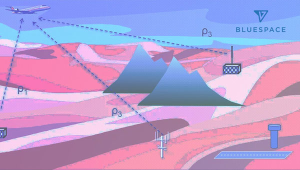
BlueSpace.ai, a Silicon Valley-based company specializing in off-road and unstructured autonomy, has released its assured positioning, navigation, and timing (A-PNT) solution. The solution — called BlueSpace Positioning Solution (BPS) — illustrates how artificial intelligence (AI) can enhance navigation precision in GPS-denied and GPS-degraded environments for both manned and unmanned vehicles.
BPS is designed to address the challenges posed by weak GPS signals, susceptible to jamming, spoofing and unintentional blockages in various environments. It can support a cross-track error, or drift error, of less than 0.3%. This surpasses the industry standard of approximately 1% error over distance traveled. BPS also aims to maintain high performance while using industrial-grade inertial measurement units (IMUs), which leads to improvements in size, weight and power (SWaP).
The AI solution is designed to eliminate geofence limitations and remove dependencies on prior training data and ultra-HD mapping.
BlueSpace.ai has participated in a variety of defense and commercial applications, including applications in challenging underground mining environments, truck and bus automation and off-road autonomy.
DJI has launched DJI Modify, its first intelligent 3D model editing software.
The solution can be integrated seamlessly with DJI’s enterprise UAVs and 3D modeling and mapping software, DJI Terra. When integrated with these products, the software can be used for aerial surveying, transportation and emergency responses.
Seamless workflow with DJI Terra
DJI Modify paired with DJI Terra offers users an end-to-end solution from modeling to model editing. Once DJI Modify has been enabled, DJI Terra files for model editing are automatically generated, including pre-identified objects and pre-processing of the model. It is designed to make repairing common 3D model defects seamless and efficient. As of early 2024, DJI Modify will only support repairing models built by DJI Terra.
Efficient 3D model editing
DJI Modify allows for model files to be quickly imported and exported to the DJI Terra and other third-party software. In the future, processed models can be shared to the cloud for online viewing and sharing via links without software installation, DJI said.
DJI Modify’s intelligent auto-repair editing supports flattening, editing textures, repairing water surfaces, removing floating parts, and filling holes. Edits can be made using one-click repairs or manually by selecting custom polygons, areas or meshes.
The software’s smoother model display technology allows high- and low-quality models to be viewed and edited in a single interface. Changes made can be synchronized across both models and previewed immediately, which allows users to address model editing issues in real-time.
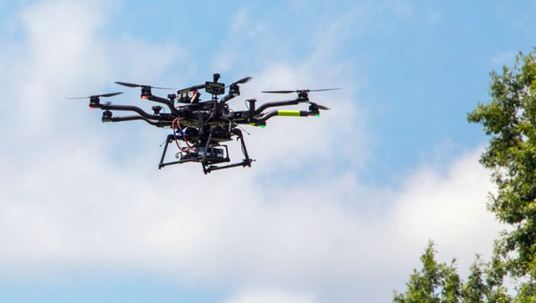
NASA researchers at Langley Research Center in Hampton, Virginia, have successfully flown multiple UAVs beyond visual line of sight (BVLOS) with no visual observer. The UAVs dodged one another and successfully maneuvered around obstacles before safely landing, the agency said. NASA conducted the tests to help researchers someday create autonomous, self-piloted helicopters that could carry passengers and cargo through busy aerospace.
Researchers used multiple Alta 8 UAVs loaded with software designed to enable autonomous flights. Although monitors observed the flights from a remote-control room at Langley, the UAVs successfully operated BVLOS.
NASA is also testing elements of autonomy using helicopters. They are designed to contribute towards the development of autonomous helicopters that can take off and land from “vertiports,” and transport passengers and cargo over both short and long distances.
The experiments are part of the agency’s Advanced Air Mobility Mission (AAM), which is designed to enable safe autonomous flight and integrate newly developed vehicles into the national airspace. The mission will “set the stage for a flourishing industry” of electric air taxis and UAVs by 2030, NASA says on its AAM website.
NASA will transfer the technology created during this project to the public to ensure industry manufacturers can access the software while designing their vehicles.
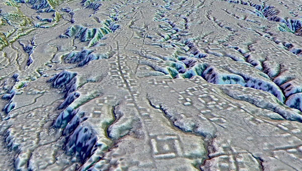
A lidar map of the city of Kunguints in the Ecuadorian Amazon reveals ancient streets lined with houses. (Image: Antoine Dorison and Stephen Rostain)
Archeologists have discovered a vast and highly complex system of ancient cities dating back nearly 3,000 years in the Amazon rainforest. Complete with a complex network of farmland and roads, the discovery is the oldest and largest of its kind in the region.
Located in Ecuador’s Upano Valley, the structures lie in the eastern foothills of the Andes mountains, according to a study published in the journal Science. After more than 20 years of research, the ancient urban centers were only discovered when the Ecuadorean government employed lidar technology.
“I have explored the site many times, but lidar gave me another view of the land,” archaeologist Stéphen Rostain, lead author of the study and director of research at the French National Center for Scientific Research (CNRS), told Live Science. “On foot, you have trees in the way, and it’s difficult to see what’s actually hidden there.”
A team of researchers from France, Germany, Ecuador and Puerto Rico conducted a lidar survey that covered roughly 300 km2. The survey revealed a landscape full of organized human activities, including more than 6,000 rectangular earthen platforms, as well as agricultural terraces and drainage systems.
According to the study, these structures formed at least 15 distinct settlements, which were connected by a system of wide, straight roads. Co-author Antoine Dorison, an archaeologist at the CNRS, said that this society’s complexity is especially evident in this web of streets, which were carefully constructed to cross at right angles rather than follow the landscape.
In recent years, lidar has been a vital tool for discovering traces of ancient civilizations. Lidar allows researchers to survey densely forested areas that are difficult to explore on foot and allows for the creation of accurate maps in a fraction of the time.
In August 2023, a team of researchers in a biological preserve in Mexico’s Campeche State used airborne lasers to cut through dense vegetation. This revealed ancient structures and human-modified landscapes beneath, including pyramids, palaces, and a ball court. The team was able to explore the dense area safely and identified the ancient Mayan city they discovered as Ocomtún.
A UK judge just jailed a student for building a UAV. How could that be? Well, the 3D-printed UAV built by a guy in his room at home was only part of the story. It turns out that his jailing was perhaps more related to his connection to the Islamic State of Iraq and Syria (ISIS), and his apparent intent to use this UAV loaded with explosives or a chemical weapon to attack ISIS enemies.
3D-printed drone seized by anti-terror officers and rear access panel (Image: West Midlands CTU/PA)
The experts who analyzed the vehicle stated that it was only partially built and appeared somewhat ‘primitive’ in its construction. It would seem that an explosive charge or chemical weapon would need to be located with its fusing circuitry at the front end of the UAV, and maybe the enclosure was rather an access panel to aid the build process.
It is unclear whether the protruding black item towards the front of the UAV is either a GNSS or communications antenna. This antenna would normally be placed on the upper skin and relatively close to the autopilot or comms radio. It is possible that there is a communications/control signal antenna at the top of the vertical stabilizer. Rudimentary landing gear can be seen aft of the control surfaces of the wing, but the rear propulsion does not appear adequate for the size of the vehicle. Not a bad attempt to create an amateur UAV, but a pretty bad idea for the guy involved to intend it to be a kamikaze, one-way drone for ISIS — he received a 20-year sentence.
Both Russia and Ukraine continue to churn out new models of one-way UAVs, which they enthusiastically hurl at one another. Russia unveiled a new swarm drone known as ‘Product 53’ which apparently has the ability to seek and identify targets autonomously.
With a payload of only 3-5 kg it cannot inflict severe damage on major targets, but the plan is apparently to bombard an area with large numbers of Product 53 controlled as a swarm.
So, Russia’s latest software-driven, sophisticated kamikaze UAV is a far cry from the primitive, partially constructed, 3D-printed UAV which lead a UK court to jail its constructor. Much more was obviously made of his encrypted online contacts with ISIS and his intent to inflict potential death and destruction on behalf of a terrorist group.
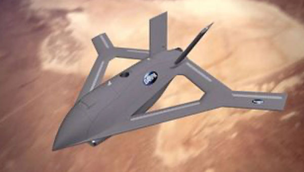
On a far brighter note, a Defense Advanced Research Projects Agency (DARPA) project known as Control of Revolutionary Aircraft with Novel Effectors (CRANE), which first went out to industry for proposals back in 2021, has now moved into Phase 3 build and manufacture following a successful Phase 2 Critical Design Review (CDR).
Aurora Flight Sciences, a Boeing Company subsidiary, has been authorized to begin building a 7000 lb X-wing manned/unmanned aircraft. The aircraft is intended to prove out a design for aerodynamic control without the use of moving surfaces.
Illustration of proposed X-Wing aircraft (Image: DARPA)
Elevators, flaps, slats and rudders on conventional modern aircraft require significant internal hydraulics and/or cabling and actuators throughout the airframe, which add to the complexity, and potential failure modes, aerodynamic drag and weight. Most current UAVs emulate these flight control systems and use external control surfaces.
The DARPA X-Wing aircraft may use compressed air jets or even electrical discharges emitted at critical actuation points along its outer surface to ‘gently push’ the aircraft from its existing path through the airstream, which allows the remote pilot to maneuver the aircraft. Known as Active Flow Control (AFC) this technology has been prototyped to one extent or another in recent years, but this DARPA/Aurora project aims to prove the concept.
For the demonstration aircraft, normal moving control surfaces will be installed and retained. The aircraft will initially be flown using these standard airflow controls to form a baseline for how the aircraft performs. The control surfaces will then be locked down and the aircraft will be flown using AFC, and the performance will be compared to the standard controls baseline.
Understandably, the earlier phases of the project likely worked through the required control systems for the unique X-wing configuration. Aurora may have been well positioned to provide such flight control systems, autopilot and software from its store of Guidance, Navigation, and Control (GNC) technology — the basis for the operation of autonomous air vehicles.
Building illicit UAVs intended for terrorism may not be one of the best academic projects to undertake when you’re an ISIS supporter; Russia and Ukraine appear to be in a race to mass produce ever more sophisticated UAVs; and DARPA/Aurora appear to be headed to a relatively heavy prototype air vehicle demonstrating not only X-Wing technology, but also active flight control. Overall, there is a variety of news on UAVs in various configurations and applications.
NV5 Geospatial’s thermal infrared (TIR) solutions for transportation infrastructure challenges are now being used in transportation projects to analyze concrete bridges in the Midwest.
This remote sensing technology offering enables local and regional transportation agencies to identify structural problems well before they reach the surface of concrete bridge decks.
Concrete bridge decks require periodic inspections for continuous maintenance, rehabilitation, and replacement work. TIR is used in non-destructive inspection techniques for analyzing concrete bridge decks and identifying potential delamination. This process is made more efficient with aerial collection.
The company recently conducted two separate pilot projects with two Midwestern states’ departments of transportation using aerial data collection to identify thermal anomalies of potential delamination for 200 bridge concrete surfaces. Both projects were completed by flying a fixed-wing aircraft at a low elevation with the thermal sensor mounted to its floor. The flights were conducted without ground-based support.
NV5 Geospatial’s project design focuses on optimal timing and resolution to maximize thermal contrast, which ensures accurate detection of features or patterns of interest. The acquired thermal imagery is orthorectified to create a seamless mosaic for each bridge. TIR imagery can be co-acquired with other airborne technologies, such as true color imagery and lidar, to provide supplementary information.
The TIR aerial solution allows users to capture up to 100 bridges in a single day and offers a detailed and short turnaround of data analysis. It identifies potential issues before ground truthing is required and supports state-wide inspection prioritizations.
ANELLO Photonics has released the ANELLO X3, its 3-axis optical gyroscope inertial measurement unit (IMU) designed for GPS-denied and challenging environments.
The IMU leverages ANELLO SiPhOG (Silicon Photonics Optical Gyroscope) technology and serves as a light, low-power tri-axial optical gyroscope offering high accuracy, performance and reliability for autonomous applications.
The ANELLO X3 can be used in a variety of applications, including autonomous commercial and defense applications involving robots, UAVs, electric vertical take-off and landing (eVTOL) aircraft and various maritime and land vehicle applications, including high-accuracy surveying and mapping.
Parts of Poland, Lithuania, southern Sweden, and other countries in the Baltic region had an unexpected Christmas present this year. GPS signals were disrupted and not available in many areas on the 25th and 26th of December. Poland seemed to be particularly impacted, with the northern two-thirds of the country affected and many users on the ground and in the air having to make do without reliable service.
On New Year’s Eve, parts of Finland experienced significant jamming as well. The most visible impacts of the holiday events were seen in aviation and low navigation integrity reports from ADS-B systems. These were displayed on the GPSJam.org website.
Experts in the United States and Poland point to Russia as the source of the interference. They say that Russian anger over the activation of a U.S. anti-missile system in northern Poland in mid-December, and Sweden’s progress toward NATO membership with a recent positive vote in the Turkish Parliament were likely motivations.
Such a reaction by Russia is not unprecedented. In 2022 President Putin threatened Finland and Sweden with invasion if they sought to join NATO. Subsequently, Finnish President Niinistö met with President Biden to discuss improving defense ties. Shortly thereafter planes flying over Kaliningrad and nearby areas in the Baltic began reporting GPS jamming. Analyses of the event by graduate students at the University of Texas Radionavigation Laboratory and Stanford University have provided some details and will likely reveal more as time goes by.
Zach Clements at U.T. studied the disruption and discovered that it included several transmitters spread across a wide area. Some were simply jamming GPS signals to deny service. At least one transmitter was spoofing aircraft so their instruments would show them far from their actual location.
While the phenomenon known as “circle spoofing” has been frequently observed with ships, this was the first time it was reported in aviation. With circle spoofing a receiver is electronically captured and “moved” to a different location. Then it is made to appear to move in circles, almost always in a clockwise direction
Image: Zach Clements/ GPSJam.org
Clements is reasonably sure the source of the circle spoofing was inside Russia. “The points at which the aircraft began to be impacted by the spoofing and where they regained authentic GPS indicate that the spoofer is somewhere in Western Russia. Interestingly, the location to which the aircraft were spoofed is a field about a kilometer from Russia’s decommissioned Smolensk military airbase.”
Zixi Liu at Stanford has discovered that the interference was actually two separate events. The first lasted from 9:30 PM on the 24th until 4:30 AM on the 25th, with the second beginning around 2:30 PM on the 25th and tapering off around midnight on the 26th.
Aviation interests have become increasingly concerned about interference with GPS signals since 2019 when a commercial passenger aircraft flying through smoke nearly impacted a mountain. Since then, aviation groups have raised the issue, national authorities have been regularly issuing warnings, and the UN’s International Civil Aviation Organization has urged its member nations to take action to prevent interference.
“Aviation is always at greater risk when GPS signals are not available or are compromised in some way,” according to Joe Burns, a senior captain at a major international air carrier. Burns is also a member of a board that advises the U.S. government on GPS and related issues. “Interference with GPS increases the risks of accidents and almost always slows the system down, makes flights longer, and more expensive,” he said.
The International Air Transport Association is meeting this month to discuss GPS interference. Most agree, though, that most meaningful short-term solutions will depend upon the cooperation of national governments across the globe.
A series of powerful earthquakes hit western Japan on Jan. 1, killing at least 55 people and damaging thousands of buildings, vehicles and boats, reported CNN. Japanese officials warn that more earthquakes could lie ahead.
Aftershocks continued to shake Ishikawa Prefecture and nearby areas after the initial magnitude 7.6 earthquake struck the area.
According to Japan’s Geospatial Information Authority (GSI), the earthquake may have shifted land in the Noto region near the peninsula, where the ocean floor shifted and generated tsunami waves of about 80cm in height. GSI said preliminary figures indicate that an observation point in Wajima City in Ishikawa Prefecture saw the biggest shift, which moved about 1.3 meters west.
Land appears to have shifted about 20 centimeters to the northwest in the prefectures of Toyama and Niigata. Several centimeters of land shifts were observed in the Kanto-Koshin region and elsewhere.
Scientists have also been watching Japan from space, comparing satellite images taken before and after the earthquake.
On its latest pass, the ALOS-2 spacecraft reported the distance between itself and the ground had shortened as the Earth’s surface had risen up under the force of the tremor.
Fortunately, the uplift may have lessened the impact of the waves when they arrived at the shoreline, said GSI.
GSI plans to continue analyzing the data for other movements.