Point One Navigation has integrated Ordnance Survey base stations into the Polaris Network, which is designed to improve accuracy, precision, reliability and interoperability in the UK. The solutions aim to aid in applications such as advanced driver assistance (ADAS), robotics, mapping and more.
Polaris is a real time kinematic (RTK) corrections network that offers cm-level accurate GNSS positioning. Polaris’ global RTK network now includes the entire United States, EU, Australia, Canada and the UK.
Existing Polaris customers can utilize the UK integration immediately, at no additional cost.
This technology is complemented by the company’s FusionEngine software, which further integrates inertial measurement, wheel odometry and additional sensors to achieve the desired level of precision, even in the absence of satellite signals.
Polaris supports all major GNSS constellations and has a dense global network of base stations, which offers improved precision acquisition time in more places, the company says. The network supports all modern navigation signals across all mobile networks.
According to Point One, it is the first localization service with a modern GraphQL-based API, which aims to improve the integration of Polaris RTK into developer-built applications. It can be used by software developers to integrate RTK into demanding applications, including industrial autonomy, precision agriculture, logistics and delivery, robots and ADAS.
It will support State Space Representation (SSR) corrections delivered by L-band satellites in early 2024, the company says, which will allow for operations to continue in the absence of cellular networks or in bandwidth constrained applications.
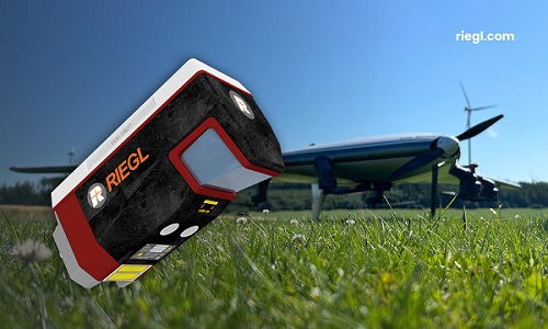
RIEGL has released three airborne survey products. The three systems are designed to enhance sensor performances and capabilities in various segments, from terrestrial, to mobile and airborne applications.
RIEGL VQX-2 – Helicopter pod for airborne surveying
Image: RIEGL
The VQX-2 helicopter pod is designed for airborne data collection. It integrates a RIEGL laser scanner, a high-performance IMU/GNSS unit, and up to five cameras. It also can be easily mounted and dismounted onto UAVs.
The VQX-2 can be used in a variety of applications such as corridor mapping, surveying large areas from high altitudes, monitoring glaciers and landslides and more. The solution includes the corresponding cabling; a “Minor Change Approval” is already available for Airbus Helicopters AS350 series helicopters.
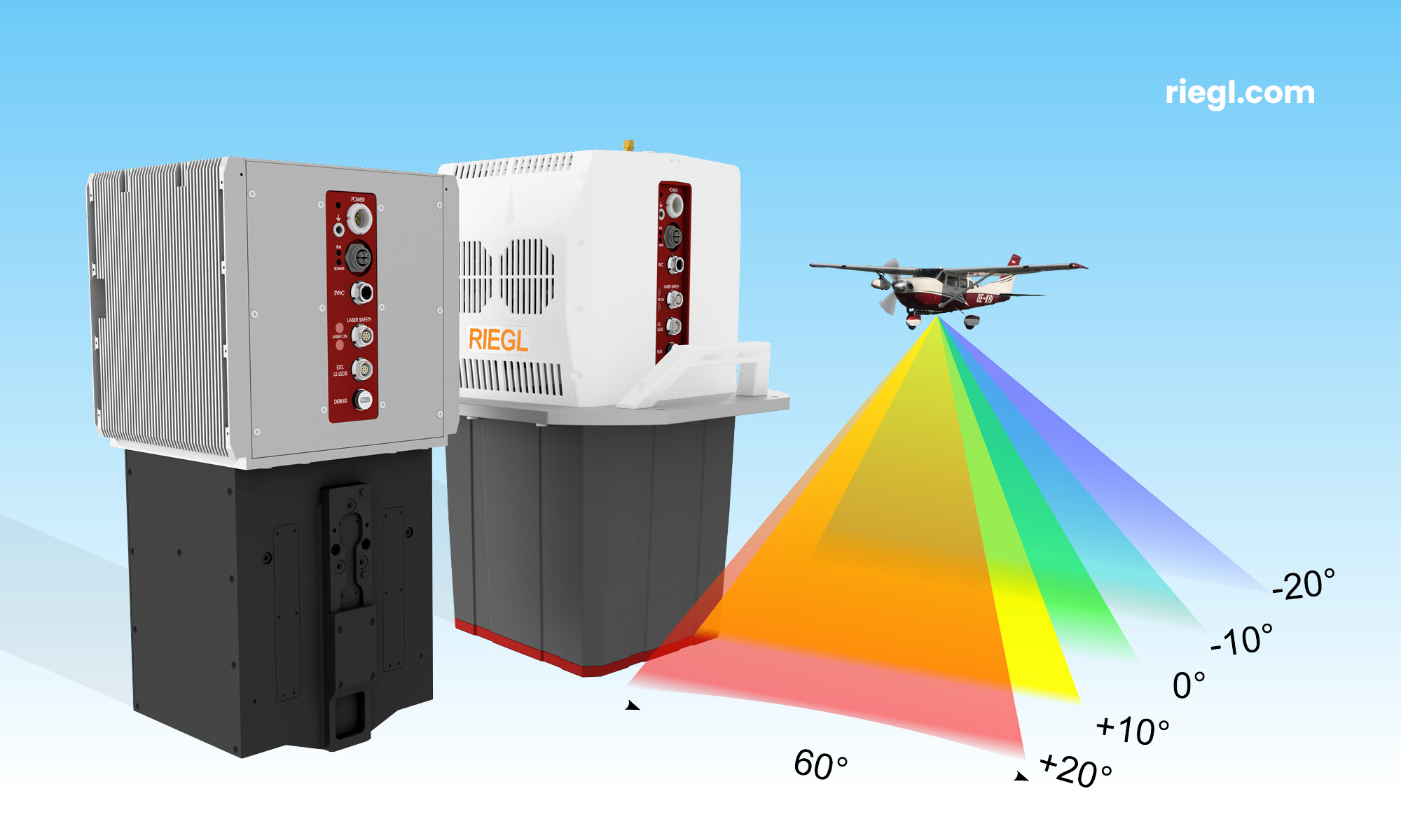
The VQ-680 compact airborne lidar scanner OEM is designed to be integrated with large-format cameras or other sensors in complex hybrid system solutions.
The module can be mounted inside a camera system connected to the IMU/GNSS system and various camera modules through a sturdy mechanical interface. It also has laser pulse repetition rates of up to 2.4 MHz and 2 million measurements per second.
The VQ-680 is ideal for large-scale applications in urban mapping, forestry and power line surveying, the company says. With a wide field view of 60º andRIEGL’s nadir/forward/backward (NFB) scanning, the system offers five scan directions up to ± 20º. This technology provides users exceptional coverage of vertical structures such as building facades or power poles at high accuracy.
The OEM’s sister type, the VQ-680, is offered as a high-end airborne lidar scanner that offers the full range of performance in a compact and lightweight scanner. This scanner can be coupled with up to six high-resolution RGB/NIR cameras and mounted onto appropriate aircraft hatches with or without using stabilized platforms.
RIEGL VUX-180-24 –UAV lidar sensor for high-speed surveying missions
Image: RIEGL
The VUX-180-24 offers a wide field of view of 75º and a high pulse repetition rate of up to 2.4 MHz. These features – in combination with an increased scan speed of up to 800 lines per second – make it suitable for high-speed surveying missions and applications where an optimal line and point distribution is required.
Typical applications include mapping and monitoring of critical infrastructure such as power lines, railway tracks, pipelines, and runways. The VUX-180-24 provides mechanical and electrical interfaces for IMU/GNSS integration and up to five external cameras. For smooth and straight forward data storage, an internal SSD memory with 2 TByte storage capacity and a removable CFast memory card are available.
This sensor can be coupled with RIEGL’s VUX-120, VU-160, and VUX-240 series UAVs. The system is available as a stand-alone sensor or in various fully integrated laser scanning system configurations with IMU/GNSS systems and optional cameras.
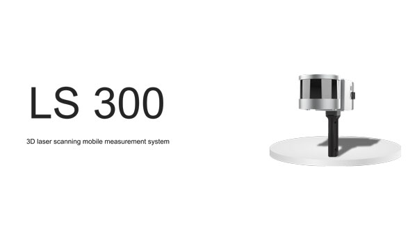
ComNav Technology has released the LS300 3D laser scanning measurement system.
The scanner utilizes simultaneous localization and mapping (SLAM) technology, and advanced real time and mapping techniques. It operates autonomously, independent of GNSS positioning, which makes it ideal for harsh conditions in both indoor and outdoor environments.
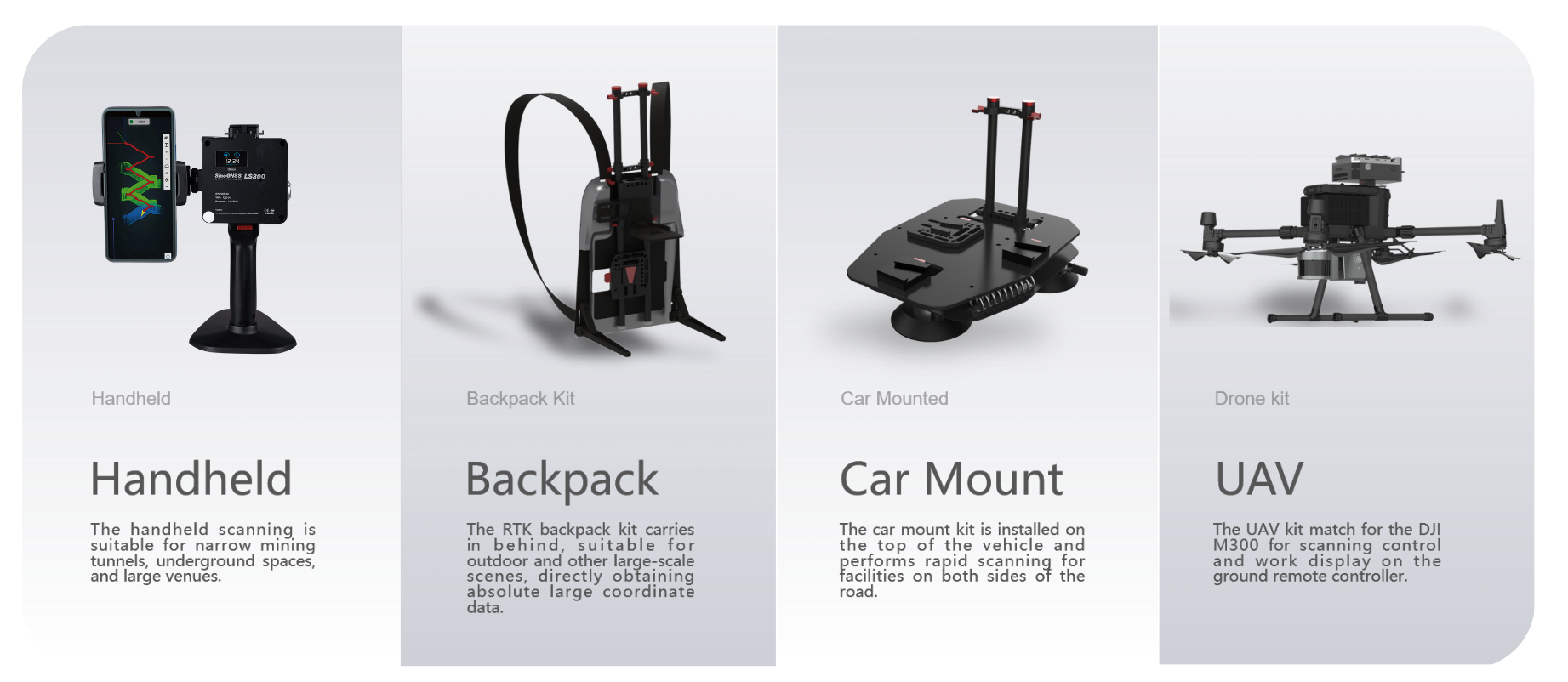
LS300 includes a 120-meter working range and a high sampling rate of 0.32 million points per second. Its point cloud accuracy is designed to perform in low reflectivity extended-range mode. The system is compatible with specialized kits, including the handheld form, back kit, car-mount and UAV kit.
Image: ComNav Technology
The handheld mode is best suited for navigating narrow tunnels and large venues, while the backpack is designed for outdoor environments. The car mount can rapidly scan roadside facilities, and the UAV kit seamlessly pairs with the DJI M300 for aerial control. The LS 300 is suitable for a variety of applications, including smart city, digitization of underground facilities, geology, surveying and mapping, agriculture, mining and forestry.
The scanner uses a unique hybrid HSL technology. This allows for preliminary processing during the scanning process, which aims to accelerates the collection of high-precision data and expedites data processing. It offers real-time viewing of point cloud data through a mobile application and supports multiple interaction modes.
By using data processing software specifically designed and developed for the LS series by ComNav, users can handle large volumes of point cloud data and simplify complex tasks, including point cloud denoising, point cloud splicing, shadow rendering, coordinate transformation, automatic horizontal plane fitting, automatic point cloud data report generation, forward photography, and point cloud encapsulation. This allows users to efficiently process intricate point cloud data, resulting in precise measurement and modeling outcomes.
During data post-processing, users can input absolute coordinates of control points, which allows these control points to make comprehensive adjustments to the data and improve scanning data accuracy.
The LS300 also incorporates a redundant battery design with two hot-swappable batteries, designed for prolonged operation without frequent charging or interruptions. This innovative approach contributes to enhanced safety, reliability, and efficiency, the company says.
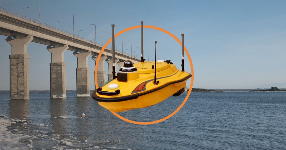
CHC Navigation (CHCNAV) has launched the Apache 3 Pro, a compact hydrographic uncrewed surface vessel (USV) designed for autonomous bathymetric surveys in shallow waters. A lightweight carbon fiber hull with IP67-rated ingress protection and semi-recessed motor provides durability and maneuverability.
Featuring CHCNAV’s GNSS RTK + inertial navigation sensor, the Apache 3 Pro offers consistent, high-precision positioning and heading data even when navigating under bridges or in areas with obstructed satellite signals. The built-in CHCNAV D270 echosounder allows for reliable depth measurement from 0.2 to 40 meters.
The Apache 3 Pro is also equipped with a millimeter-wave radar system that detects obstacles within a wide 110° field of view. When an obstacle is encountered, the USV autonomously charts a new course to safely navigate around it. The vessel uses both 4G and 2.4GHz networks to facilitate effective data transfer.
Weighing only 10 kg, it features a lightweight macromolecular polyester carbon fiber and Kevlar composite hull for improved resilience. Even with a fully integrated payload, the USV can be easily deployed and controlled by a single operator in a variety of environmental conditions.
The Apache 3 Pro ensures reliable communications through its integrated SIM and network bridge with automatic switching. It also features seamless cloud-based remote monitoring that offers real-time status updates to enhance control and security. Its semi-recessed brushless internal rotor motors minimize drafts, which can improve the USV’s maneuverability in varying water depths.
Electronic warfare in the Middle East and Ukraine is affecting air travel far beyond the battlefields, unnerving pilots and revealing unintended consequences of a tactic that experts believe will become more widespread, reportedThe New York Times.
Planes are losing satellite signals, flights have been diverted and pilots have received false location reports or inaccurate warnings that they were flying close to terrain, according to European Union safety regulators and an internal airline memo viewed by The New York Times. The Federal Aviation Administration (FAA) has also warned pilots about GPS jamming in the Middle East.
Following Russia’s invasion of Ukraine in early 2022, radio frequency interference only continues to increase across the Middle East as of autumn 2023. These interferences can involve jamming GNSS signals to obstruct or block them using noise, or mimicking signals to trick GNSS receivers into picking up counterfeit satellite signals, known as spoofing.
Aircraft systems have been unable to detect GPS spoofing and ultimately correct for it. According to Opsgroup, an organization that monitors changes and risks in the aviation industry, one Embraer jet bound for Dubai nearly veered into Iranian airspace in September before the pilots figured out the plane was chasing a false signal.
“We only realized there was an issue because the autopilot started turning to the left and right, so it was obvious that something was wrong,” crew members reported to Opsgroup.
Issues arise
With the rise of electronic warfare, the strain on aviation could be a sign of more serious economic and security issues.
The U.S. government calls GNSS signals “an invisible utility.” Smartphones, cars, stock exchanges, data centers and countless industries rely on them for time, navigation or both. Similar systems exist around the world, such as Galileo in Europe, Glonass in Russia, QZSS in Japan, NavIC in India and BeiDou in China. One study from Britain said a five-day disruption of satellite signals could cost the country $6.3 billion.
Minor interference with GPS signals is fairly common. GPS jamming devices, while illegal to use, are inexpensive and easy to obtain from vendors on the internet. Governments, too, have been more willing to overtly interfere with signals as a tactic in electronic warfare.
It is not always possible to distinguish jamming from spoofing, or to determine who is behind the interference. Israel said in mid-October it had restricted GPS in the region and had warned pilots not to rely on satellite navigation systems for landing.
Russian interference is well-documented. A 2019 report by the Washington-based analytical nonprofit group C4ADS showed extensive spoofing from a Russian-controlled air base in Syria. Reports also indicated that, when Russian President, Vladimir Putin, traveled to remote locations or Russian-occupied Crimea, he was flanked by mobile GPS-spoofing technology.
Jamming is common in conflict zones. Spoofing, until recently, was considered rare.
The interference has been felt up to 190 miles away from battlefields and “appears to go well beyond simple military mission effectiveness,” according to Eurocontrol, Europe’s primary air-traffic-control manager. The worst-affected regions include the aerial space above the Black Sea area from Turkey to Azerbaijan; the Mediterranean Sea extending from Cyprus to Libya; the Baltic Sea near Poland and Latvia; and the Arctic near Finland and Norway.
Airbus said it recorded nearly 50,000 interference events on its aircraft last year, more than four times as many as the year before. This came on top of an over twentyfold jump in radio-interference events from 2017 to 2018, as recorded by a voluntary incident reporting system run by Eurocontrol. Eurocontrol said the increased jamming since 2018 was most likely meant to interfere with battlefield UAVs.
In the Middle East, there have been reports of false signals telling pilots their aircraft were directly above the airport in Tel Aviv despite being far away. Opsgroup said it had received around 50 similar reports. In some cases, onboard equipment showed that planes were approaching airports in Baghdad, Cairo or Beirut, Lebanon, when they were not.
Looking ahead
Spoofing is hard to distinguish because the signal appears legitimate. Only Europe’s Galileo incorporates an authentication system that can verify when a signal is from its satellites. Galileo, which currently is the most accurate and precise navigation satellite system, plans to introduce an even stronger level of authentication, according to the European Commission.
But even Galileo’s authentication cannot protect against one of the most dreaded types of spoofing, known as “meaconing.” In a meaconing attack, a spoofer would record satellite signals, and then rebroadcast them with an amplification or a delay. Experts have not publicly confirmed any meaconing attacks in the Middle East.
Opsgroup said the latest events should prompt manufacturers to re-examine the integration of satellite signals in aircraft electronics, known as avionics, without a safeguard that can identify false signals.
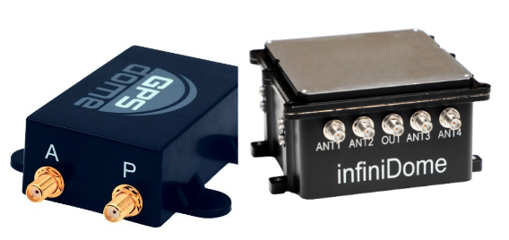
In this environment of intentional GPS jamming and spoofing, Israel has produced a leading anti-jam technology company, InfiniDome, located in Caesarea. According to co-founder Omer Sharar, the company has been working to defend GPS signals for more than seven years and has also seen the rise of devices to jam the GPS L1 frequency that anyone can buy online for $100.
Most readily available jammer electronics only output interference disrupting GPS L1, which is commonly installed for vehicle tracking and UAV guidance. InfiniDome says it has successfully protected trucking, UAV operations and others in Israel and around the world with its Infinidome GPSdome-1 and GPSdome-2 anti-jam products.
It is clear the conflict’s repercussions extend well beyond the battlefield, highlighting the critical need for security assessments or alternative PNT systems to protect civilians. While there is going to be a significant impact on commercial airline travel to and from Israel while hostilities continue, there is hope for a possible long-term solution for the intense jamming that has plagued the region for years.
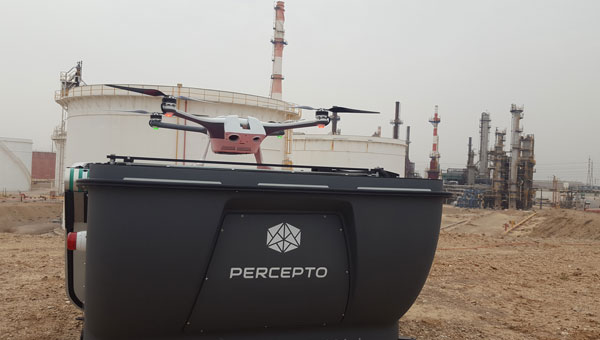
The Federal Aviation Administration (FAA) has granted Percepto a nationwide waiver to operate a full fleet of its UAVs remotely by one operator.
Prior to the approval, Percepto UAVs required one pilot per UAV. Now, users can operate up to 30 drone-in-a-box systems simultaneously with one pilot. The waiver aims to improve the capabilities of beyond visual line of sight (BVLOS) UAV operations across the U.S. By utilizing remote pre-flight checks and advanced automation, this waiver eliminates the need for human interference or expensive radars.
According to the company, the approval is the final regulatory step to achieve large-scale remote UAV operations, following the recent approval for nationwide BVLOS operations.
Percepto’s drone-in-a-box systems consist of a UAV that operates out of a docking station, often used in remote or hard-to-access locations. When set up with a power source and internet connection, the docking station charges and autonomously operates the UAV, allowing operations to run 24/7 and reducing reliance on human presence or interference.
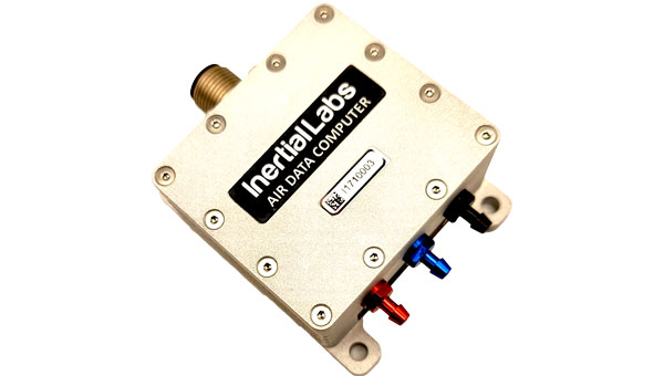
Inertial Labs has introduced its ADC inertial navigation system (INS) designed to calculate and provide air data parameters, including altitude, air speed, air density, outside air temperature (OAT) and windspeed for avionic applications.
ADC’s compact form makes it easy for users to integrate into existing UAV systems with strict size and weight requirements. The INS calculates the air data parameters using information received from the integrated pitot and static pressure sensors, and an outside air temperature probe.
This compact device consumes less than one watt of power. It is designed for the most demanding environments, has a IP67 rating, and integrates total and static pressure sensors to calculate indicated airspeed accurately. ADC also supports aiding data from external GNSS receivers and ambient air data, which enhances its precision in a variety of flight conditions.
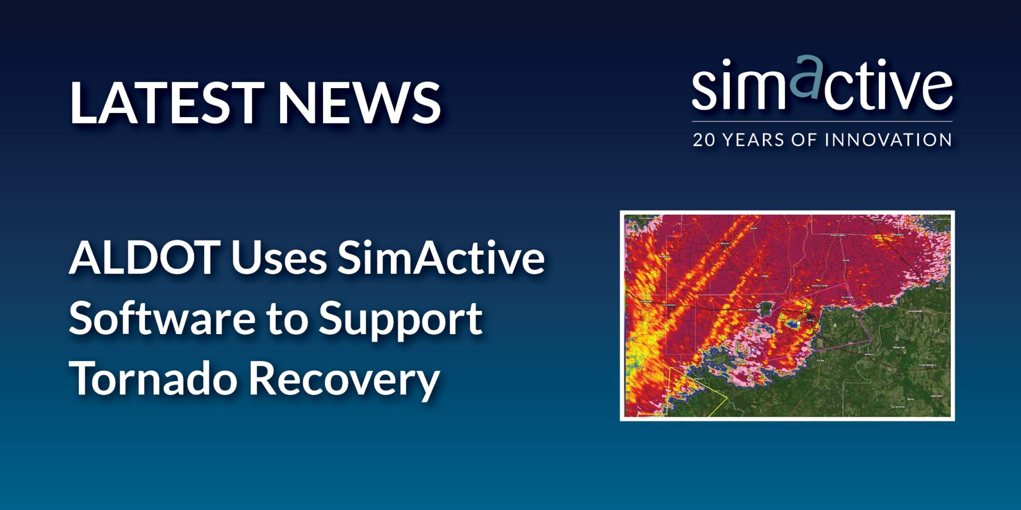
SimActive Inc., a developer of photogrammetry software, and the Alabama Department of Transportation (ALDOT) have partnered to use SimActive’s Correlator3D software to process UAV imagery for damage assessment.
In early 2023, a powerful tornado ripped through the southwest portion of the city of Selma, Alabama. ALDOT quickly collected more than 18,000 images of the area. The SimActive software allowed the team to process the data within 24 hours and deliver digital surface models and orthomosaics.
Correlator3D is an end-to-end photogrammetry solution designed to generate high-quality geospatial data from satellite and aerial imagery, including UAVs. The software performs aerial triangulation (AT) and produces dense digital surface models (DSM), digital terrain models (DTM), point clouds, orthomosaics, 3D models and vectorized 3D features.
Powered by graphics processing unit (GPU) technology and multi-core central processing units (CPU), Correlator3D offers enhanced processing speed to support the quick and efficient production of large datasets.
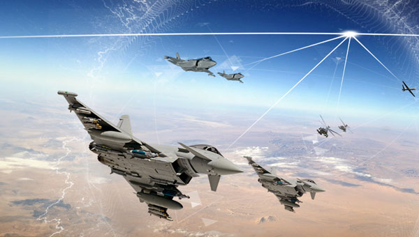
BAE Systems’ digital GPS anti-jam receiver (DIGAR) has entered the next phase of the Phase 4 Enhancements (P4E) capability program for the Eurofighter Typhoon.
DIGAR is designed to enhance the Typhoon’s ability to withstand GPS signal jamming, spoofing, and radio frequency (RF) interference, ensuring optimal mission execution in challenging RF environments.
The receiver uses advanced antenna electronics, high-performance signal processing and digital beamforming for improved GPS signal reception and jamming immunity, which aim to increase the level of GPS jamming protection. These capabilities are critical for combat aircraft as they maneuver through a contested battlespace.
This upgrade, coupled with BAE Systems’ GEMVII-6 airborne digital GPS receiver, reinforces the Eurofighter Typhoon’s role as a component in air security for the UK and its international allies.
In addition to Typhoon, DIGAR is also installed on the F-16, F-15, and other special-purpose aircraft in the United States such as air interdiction and force protection platforms, intelligence, surveillance or reconnaissance aircraft and UAVs.
An expert safety review team assembled by the Federal Aviation Administration (FAA) addressed several near-misses at U.S. airports in recent months. The group has called for “urgent action” to be taken to maintain airline safety.
The National Airspace System Safety Review Team released a 52-page report on Nov. 15, which cited air traffic control staffing shortages, technology issues and funding needs as the suspected reasons for the incidents.
The review team, which includes former FAA executives, a former National Transportation Safety Board chairman and former aviation union leaders, was established in April 2023. The group was tasked with examining the air traffic control system and delivering recommendations on how to enhance safety, according to the FAA.
Additionally, the report said that past investments in overhauling FAA technology have worsened the agency’s technology. Newer systems are being layered on top of older systems, and few of the old systems have been decommissioned or replaced, according to the report.
The old systems are becoming difficult to maintain because companies have gone out of business, spare parts are no longer available and the older workers who installed the technologies are retiring without passing knowledge onto younger employees. The equipment replacement backlog is $5.3 billion.
The panel also called for significant changes to the way air traffic controllers are trained. The report said using upgraded simulators and removing “unnecessary and outdated curriculum” could lead to faster certification and more employees.
Transportation Secretary Pete Buttigieg said the FAA is 3,000 controllers short of its goal, and according to the union representing controllers, the ranks grew by only 6% in the past year. If the current hiring plan is followed, only 200 empty seats would be filled, the report said.
The understaffing is causing controllers to work significant amounts of overtime, which the report said is causing “absenteeism, lower productivity and fatigue.”
The report comes as the National Transportation Safety Board is conducting separate investigations into several of the near collisions, one involving a near collision in Boston and a collision involving two private jets in Houston. The near misses have since caught the attention of Congress. A Senate subcommittee held a hearing on Nov. 9, where Jennifer L. Homendy, chairwoman of the National Transportation Safety Board, stressed the importance of safety checks to maintain airline safety.
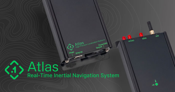
Point One Navigation has introduced the Atlas inertial navigation system (INS) designed for autonomous vehicles, mapping and other applications.
Traditional INS solutions have typically relied on extensive post-processing to reach the high precision levels needed for accurate mapping and observability applications. In contrast, Atlas can provide users with ground-truth level accuracy in real-time, which can streamline engineering workflows, significantly reduce project costs and improve operational efficiency.
Atlas is designed to be used in large fleets. It integrates a highly accurate, low-cost GNSS receiver and IMU with the Polaris RTK corrections network and Sensor Fusion algorithms. The company aims to make it easier for businesses to equip their entire autonomous fleets with high-accuracy INS.
The system features a user-friendly interface, on-device data storage and both ethernet and Wi-Fi connectivity. Field engineers can easily configure and operate Atlas using smartphones, tablets and in-car displays.
Atlas aims to drive innovation across a variety of sectors, including autonomous vehicles, robotics, mapping and photogrammetry. Its real-time capabilities and affordability can enhance the widespread deployment of ground truth-level location in fleet operations.
Inertial Labs has been awarded an SBIR Phase III contract by the Army Applications Laboratory of Army Futures Command. This award supports Inertial Labs development, design and fabrication of the Cannon Artillery Pointing and Sighting System (CAPSS) for potential use on the U.S. Army’s Paladin and the extended range cannon artillery (ERCA) vehicles.
The CAPSS aims to dramatically reduce weight on the target vehicle platforms by providing a digital replacement for the vehicle’s current panoramic telescope (PANTEL). The PANTEL is used as a sighting system for the gun when the fire control system is inoperable. The CAPSS prototype is being designed to physically replace the PANTEL.
CAPSS is a collection of cameras, inertial measurement units (IMUs), advanced electronics and an intuitive tablet-based user interface. Designed to digitally mirror the PANTEL, the CAPSS system allows soldiers to emulate all PANTEL functions via the tablet, bypassing the need to physically manage the telescope.
More than 400 lbs in equipment weight is eliminated by replacing the current equipment with CAPSS, which improves the vehicle’s operational efficiency. Additionally, the features integrated within CAPSS eliminate the need for warfighters to leave the vehicle cabin for typical aiming and sighting activities connected to the PANTEL setup, such as working with the auto-collimator. All of the functionalities are inherently embedded in the CAPSS, which simplifies operations.
The CAPSS camera technology is also used for semi-automated ranging capabilities. Warfighters can effortlessly zoom in on specific objects, offer estimated data based on the object’s attributes, such as size estimation, and the system will generate the estimated range to that particular object.
Looking ahead, Inertial Labs plans to continue research on optical/inertial-based GPS-denied navigation designed for land vehicles, integrating both camera systems and inertial sensor data.