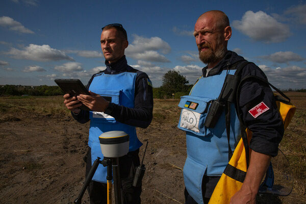
Trimble has partnered with HALO Trust, a landmine-clearing non-profit organization, to help expand its demining operations across Ukraine.
The grant from the Trimble Foundation Fund will focus on strengthening the HALO Trust’s ability to locate and remove landmines, unexploded ordnance and other explosive hazards from civilian areas to create safer communities. In addition, it will allow HALO to support the Ukrainian national authorities in planning and coordinating landmine clearance activities by streamlining the mapping and data flow from the operational teams in the field to the national database.
The Russian invasion of Ukraine has left areas of the country contaminated with landmines, unexploded ordnance and improvised explosive devices. These hazards block access to farmland, impede reconstruction efforts, prevent displaced persons from returning to their homes and continue to hinder the safety of Ukrainian civilians. The Ukrainian government estimates that 174,000km2 of the country’s land may be contaminated.
More than a thousand HALO staff members are active daily, both to clear explosives in critical priority areas and to recruit and train hundreds of new staff members to help keep communities safe from dangerous weapons left behind.
Surveying and mapping technology has played a significant role in the success of HALO’s operations around the world, including in Ukraine. Over the last six years, Trimble R1 and Trimble R2 GNSS receivers along with Esri ArcGIS Survey123 software have been used by HALO to identify and clear landmines.
Trimble’s Geospatial and Positioning Services businesses provided HALO with a new deployment of 255 high-precision Trimble DA2 GNSS receivers with Trimble Catalyst corrections service, allowing HALO to modernize and transform its landmine clearance operations by providing improved accuracy for more detailed maps, streamlined data flows and increased operational efficiency and safety.
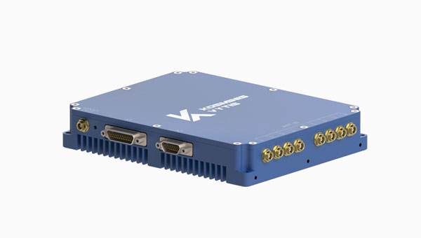
Kosminis Vytis has released two anti-jamming receivers, the KV-AJ3 and KV-AJ3-A, and an 8-channel, controlled reception pattern antenna (CRPA), anti-jamming development kit.
Image: Kosminis Vytis
The KV-AJ3 tri-band anti-jamming receiver combines a digital antenna control unit (DACU) and a GNSS receiver. KV-AJ3 can be used as a jamming protector for legacy receivers or as a stand-alone GNSS receiver solution.
When used with a Kosminis Vytis multi-band 4-channel antenna array, anti-jamming DACU uses the Null-Steering algorithm based on classic auto-compensator architecture and channel equalization, which eliminates the jamming signals from those processed by the receiver.
The tri-band solution decreases interferences from up to three directions in three frequency bands, including S-band, according to the company. This approach is designed to provide significantly higher protection against interference compared to single-frequency devices.
The receiver has a digital port for navigation data output. Jamming-free RF signals can also be delivered to external non-protected GNSS receivers to obtain position, velocity and time.
KV-AJ3 contains a MEMS inertial sensor, which allows for GNSS-aided INS solutions where coordinates and attitude angles are required.
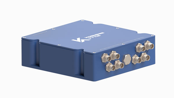
Image: Kosminis Vytis
The KV-AJ3-A is designed to provide a stable navigation signal in three frequency bands, including S-band, even in the presence of jamming and other harsh conditions. The technology is MIL-STD compliant and meets the EMI/EMC requirements for avionics.
The direction to interfering signals is determined using a phased array antenna, which can then remove jamming signals from up to three directions. The original signal is either restored and delivered to external GNSS receivers or processed by the internal receiver to obtain position data. The device can be used as a DACU for legacy receivers, or as a stand-alone GNSS receiver solution.
According to Kosminis Vytis, the key components of this anti-jamming device are based on custom ASICs that allow users to achieve high jamming suppression and SWaP. KV-AJ3-A can be used for fixed installations and land, sea and air platforms, including UAVs.
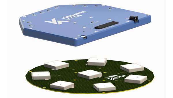
Image: Kosminis Vytis
The 8-channel, CRPA, anti-jamming development kit is a set of instruments designed to help users add anti-jamming and anti-spoofing capabilities to their receivers.
The main development tool is NT1069x8_FMC — an 8-channel receiver board. The 8 coherent channels are based on NT1069, the RF application-specific integrated circuit (ASIC) that supports a high dynamic range of input signals.
Each channel performs amplification, down-conversion of GNSS signal to intermediate frequency (IF) and subsequent filtering and digitization by 14-bit ADC at 100 MSPS.
The board is compatible with GPS, GLONASS, Galileo, BeiDou, NavIC (IRNSS) and QZSS signals in L1, L2, L3, L5 and S bands. Each RF channel has an individual RF input with the option to feed power to an active antenna.
The board also has an embedded GNSS receiver and an up-converter, or modulator, which can provide connection to an external GNSS receiver.
Under a technology license, Kosminis Vytis provides users interested in developing their solutions based on the NT1069 chip with a reference design of anti-jamming receiver, anti-jamming algorithms and software tools for the development and evaluation of anti-jamming receivers.
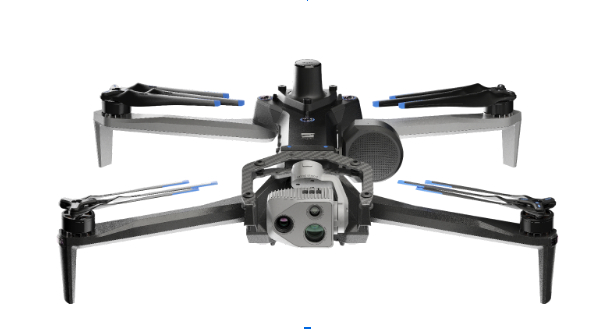
Skydio has entered a strategic collaboration with Trimble to create an integrated workflow of accurate data capture, visualization and analytics. The workflow is designed to address the needs of critical infrastructure industries such as surveying, mapping and inspections.
The collaboration, currently in the developmental stage, aims to offer users centimeter-level accuracy in surveying and mapping projects by integrating Skydio autonomous UAVs with Trimble GNSS receivers and software. The technology can be used by construction and utility companies, as well as state transportation agencies, to streamline workflows for greater precision and project efficiency.
Industry leaders rely on autonomous UAVs with powerful visual and thermal camera sensors, such as Skydio’s X10, for their ability to capture real-time condition reports of critical infrastructure conditions. By capturing images and geospatial data early and frequently throughout construction projects, organizations can easily ensure on-site work matches the design and reduce costly rework.
When bridge or utility site inspections need to scale, the Skydio and Trimble integration can be used to collect comprehensive data and improve the necessary workflow to identify issues early and take action to prevent failures.
According to Skydio, key benefits of the collaboration include:
Automated data integration: An automated, API-based integration enables seamless transfer of aerial imagery and metadata from Skydio Cloud to Trimble Industry Cloud. It accelerates the conversion of reality-capture data into actionable insights to improve efficiency. Further refinement and analysis of the output data can be carried out in professional surveying and mapping environments such as Trimble Business Center (TBC).
Survey-grade accuracy with Skydio X10: The X10 UAV will be fully compatible with Trimble’s GNSS receivers, allowing mutual users to achieve survey-grade accuracy in mapping missions when employing Skydio alongside Trimble’s base stations and GNSS receivers. Beyond RTK, users will also be able to conduct PPK based corrections post-flight.
The European Union is in the final stages of completing a deal with SpaceX to launch four Galileo navigation satellites in 2024, reported SpaceNews.
In press briefings during the European Space Summit in Seville, Spain, Thierry Breton, the European Commission’s commissioner for the internal market, said that he was “finalizing the discussions” for a pair of Falcon 9 launches, each carrying two Galileo satellites, tentatively scheduled for April and July of 2024.
Brenton also said that the final obstacle to completing the launch contract was negotiating a security agreement to protect sensitive technologies on the Galileo satellites, which previously had been launched from the European spaceport in French Guiana, when those satellites are being prepared for launch from the United States.
The launch contract itself was completed in July, Breton noted, and that the European Commission had approved a European Space Agency proposal to use the Falcon 9 for launching those satellites. He said the European Commission would spend $192 million on the Falcon 9 launches.
During a recent meeting of the European Space Agency (ESA) Council, ESA Director General Josef Aschbacher said that the final decision for using SpaceX to launch the Galileo satellites was in the hands of the Commission.
“We have prepared on the ESA side the contractual arrangements with an external launch company, but whether or not the launch will be decided to take place with SpaceX is not in our hands,” he said. “the European Commission will decide.”
There had been discussions for more than a year about using a non-European rocket, such as the Falcon 9, for launching those satellites because of delays in the Ariane 6, the retirement of the Ariane 5 and the withdrawal of the Soyuz after Russia’s invasion of Ukraine. Those satellites would augment the existing operational Galileo constellation and serve as on-orbit replacements if other satellites fail.
ESA had already contracted with SpaceX for three Falcon 9 launches. The ESA said it chose the Falcon 9 after the loss of the Soyuz, delays in the Ariane 6 and concerns about the Vega C, which remains out of service since a launch failure in December 2022.
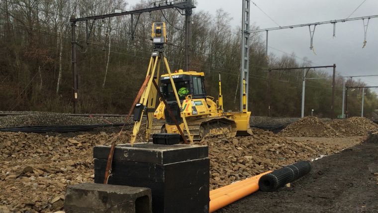
Belgian government-owned railway company, Infrabel, is responsible for ensuring that the country’s railway systems run smoothly. To do this, the company recently needed to renew the switches and crossings at the Kinkempois site, located in the Liege region of the country.
To ensure an efficient, safe and high-quality changeover, Infrabel partnered with construction specialist Jérouville, and when it came to choosing technology to help guide its machinery, the contractor turned to Topcon Positioning for its total station solutions.
According to Stéphane Lemaire, equipment manager at Jérouville, the team first dismantled and removed the previous set of foundations and the sub-foundations at Kinkempois. From there, the team installed new foundations to ensure the new switches have a good grounding for years to come.
At the site, navigation capabilities were compromised due to interference from overhead power lines. As a resolution, two Topcon total stations were used; one for each crawler dozer. Despite the challenging circumstances, the total stations were able to provide accurate readings for each dozer.
Before the bulldozers could get to work, surveyors used the data from the total stations to create three-dimensional models of the finished project using Topcon’s MAGNET software. These models were then shared with all stakeholders on the project. The MAGNET software allowed the entire team to have complete oversight of the project, whether they were on-site or back in the office.
Stéphane Lemaire said in a press release that Topcon’s total stations played a key role in getting the job done accurately on the first try.
“Traditionally, this has been a time-consuming process for projects like this, with a tracker on site who would manually ensure that the levels were correct,” Lemaire said. “However, with total station technology, the process only took three shifts across two weekends, compared to six shifts across two weekends.”
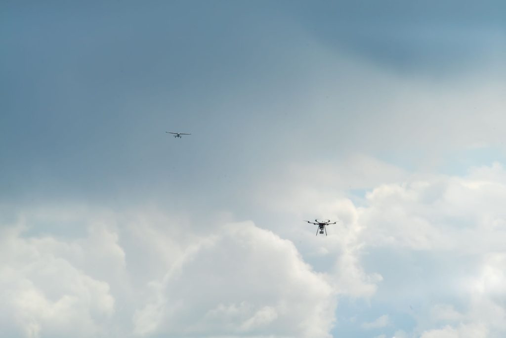
Vigilant Aerospace Systems, a provider of multi-sensor detect-and-avoid safety systems for UAVs and advanced air mobility (AAM), has been awarded a contract by the U.S. Air Force to develop a detect-and-avoid system for the Air Force’s new long-endurance UAV.
According to the published project description, the objective is to “integrate a mature detect and avoid capability on an existing long-endurance, Group V UAS platform, for increased aircraft and pilot-in-the-loop operational awareness that leverages new and evolving C-SWaP sensors and sensor fusion software.”
The project is sponsored by the Air Force Research Lab (AFRL) and is a Small Business Innovation Research (SBIR) Phase II project through the SBIR program. The program is designed to bring dual-use technologies, which can help both civilian and military users, into the military, with a focus on high-impact, near-term implementations.
FlightHorizon is detect-and-avoid and airspace management software that combines data from aircraft transponders, radar, UAV autopilots and live Federal Aviation Administration (FAA) data to create a single picture of the airspace around a UAV. The software displays air traffic, predicts trajectories and provides avoidance commands to the remote pilot or autopilot. The system can be used on the ground or onboard the UAV and can be configured for any size of aircraft.
The software is based on two licensed NASA patents and the company has completed contracts with NASA, the FAA and a project with the USAF’s 49th Operating Group’s MQ-9 Reaper fleet to track training flights. It is designed to meet industry technical standards and to help UAS operators fly beyond visual line-of-sight (BVLOS).
The new Air Force project incorporates prior research and development by the company in solving the automatic self-separation and collision avoidance problem for UAVs. To evaluate sensors and algorithms and establish standards-compliance and risk ratios, the company has completed hundreds of hours of flight tests with the system and thousands of simulated aircraft encounters inside the software’s built-in simulation engine, according to Vigilant Aerospace Systems.
SwissDrones, a global manufacturer and operator of long-range uncrewed helicopter systems for inspection, surveillance and public safety applications, has announced its SDO 50 V2 multi-mission, single-turbine uncrewed helicopter system has received Federal Aviation Administration (FAA) authorization.
This authorization allows aerial service provider Phoenix Air Unmanned (PAU), partner of SwissDrones, to operate the SDO 50 V2 beyond visual line of sight (BVLOS) across the U.S. This achievement marks the first-of-its-kind authorization within the United States, allowing PAU to broaden its capabilities in inspection, patrol and survey missions over extensive distances.
SwissDrones and PAU collaborated over the course of three years to build a concept of safe BVLOS operations (CONOPS) and conducted numerous flight trials in the U.S. using the SDO 50 V2. All regulatory and safety requirements were met in cooperation with the FAA to enable extended-range inspection and patrol flights over linear infrastructure under the same regulations as traditional-crewed aircraft.
PAU intends to use this aircraft for a variety of data-gathering tasks, including high-resolution imaging, lidar data collection and thermal imaging.
Depending on the specific sensor package and operating area, PUA inspection flights can span distances of more than 60 miles, allowing operators to conduct multiple inspections efficiently within a single flight.
With a maximum weight of 191 pounds, the SDO 50 V2 can carry sensors weighing between 30 and 70 pounds and maintain flights lasting over three hours. These extended flights make it ideal for missions requiring multiple sensors, offering nearly ten times the endurance and three times the lift capacity compared to aircraft weighing under 55 pounds that operate under Part 107 waivers.
The SDO 50 V2 has also received a Special Airworthiness Certificate (SAC-EC) from the FAA. SwissDrones is among the first organizations to obtain a European drone operator license, the European Union Aviation Safety Agency (EASA) Light UAS Operator Certificate (LUC). This certificate grants SwissDrones the authority to self-authorize flight operations for its aircraft across EASA countries, encompassing BVLOS operations within the specified certificate limits. Additional regulatory approvals from civil aviation authorities will be announced in the coming months.
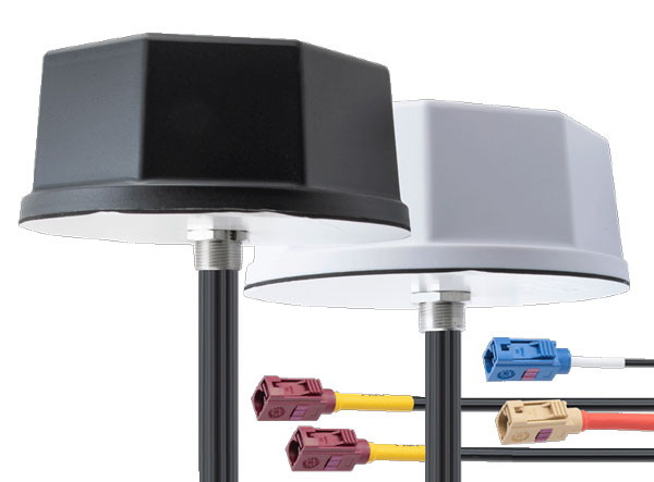
Pasternack has launched its new line of IoT multiband combination antennas. Designed for vehicles, fleets and pivotal base stations, the technology aims to revolutionize how industries perceive and use mobile connectivity.
The antennas integrate 4G, 5G, Wi-Fi and GPS bands to offer emergency teams, on-the-move fleets and first responders an unwavering link, even in harsh environments.
Facilitated with both FAKRA and SMA connectors and extended 17-foot cable leads, users can seamlessly integrate the technology. It also has an IP69K rating, certifying it for both indoor and outdoor deployments.
MIMO capabilities improve data transmission speeds and reliability, ensuring consistent high-bandwidth connections. The antenna’s GPS/GNSS component, enhanced with LNA and amplified by a 26 dB gain, offers users improved navigation and tracking precision.
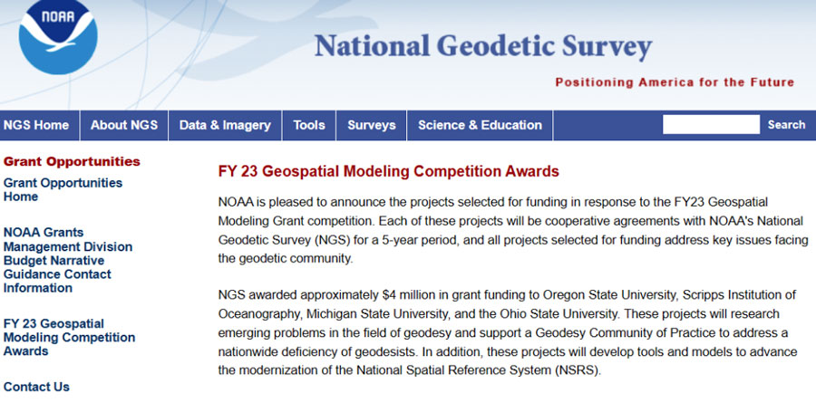
In my last column, I highlighted the announcement made by the National Geodetic Survey (NGS) of the recipients of the NOAA FY 23 Geospatial Modeling Competition Awards. As shown in the image below, NGS awarded approximately $4 million in grant funding to four institutions for projects that will research emerging problems in the field of geodesy, develop tools and models to advance the modernization of the National Spatial Reference System (NSRS), and help address a nationwide deficiency of geodesists.
Image: NGS
I had the opportunity to speak with Juliana Blackwell, director of the NGS, about the geospatial awards. I asked her how the grants will help NGS in its development of products and services as well as the implementation of the modernized NSRS.
“The geospatial modeling grant is an opportunity to expand our abilities within NGS to address research challenges, diversify the tools we provide, and multiply our future workforce,” Blackwell said. “I’m excited about the competitive and collaborative nature of the grant and the chance for NGS to work with a variety of academic institutions.”
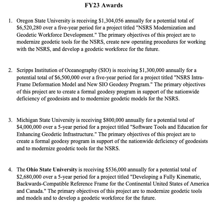
NGS awarded the grant funding to four institutions including Oregon State University, Scripps Institute of Oceanography, Michigan State University, and the Ohio State University. Looking at the summary of the awards, there appears to be some overlapping interest between grantees that could lead to a diverse set of solutions to a problem or task. I will report on specific tasks and outcomes as more details become available.
I was pleased to see that grant proposals included developing new geodetic tools and operating procedures for working with the new, modernized NSRS. Hopefully, these universities will engage the geospatial user community when developing new tools so the tools will be useful during the implementation of the new NSRS.
Summary of the Geospatial Awards (Image: NGS)
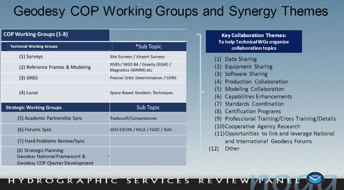
Besides providing funds for the geospatial grants, NGS is collaborating with other federal agencies to address the geodesy crisis. This collaboration, denoted as the “Geodesy Community of Practice (COP),” includes four agencies — NGS, National Geospatial-Intelligence Agency (NGA), National Aeronautics and Space Administration (NASA), and United States Geological Survey (USGS). The co-chairs of the group discussed the group’s actions and goals at the Hydrographic Services Review Panel (HSRP) fall committee meeting held in Silver Spring, Maryland, on Sept. 27-29.
Geodesy Community of Practice. (Image: NOAA’s Hydrographic Services Review Panel)
The HSRP involves four NOAA offices: three National Ocean Service (NOS) program offices -NGS, the Center for Operational Oceanographic Products and Services (CO-OPS), the Office of Coast Survey (CS), and the University of New Hampshire’s Joint Hydrographic Center and Center for Coastal and Ocean Mapping. More information and the presentations from the HSRP meeting can be obtained here. The purpose of the committee is to review and provide NOAA with independent advice on their products and services.
I attended the three-day HRSP meeting as a virtual participant. As previously noted, NGS is one of the NOS offices that’s part of the HSRP. As the Director of NGS, Blackwell participated in the 2023 fall HSRP meeting. A majority of the meeting discussed the geodesy crisis. In my opinion, this is due to Blackwell’s efforts to highlight the importance of geodesy to NOAA products and services.
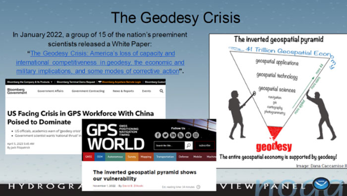
The presentation by the co-chairs of the Geodesy Community of Practice highlighted a few articles that have brought the geodesy crisis to the attention of the geospatial user community. Anyone keeping up with my columns knows that I have been highlighting the geodesy crisis and programs that advance the science of geodesy (July 2020, November 2022, December 2022, and April 2023). The geodesy crisis white paper is posted on the American Association for Geodetic Surveying (AAGS)website.
Image: NOAA’s Hydrographic Services Review Panel)
The Geodesy COP established working groups to address topics that are important to all geospatial users. All the agencies are supporting the working groups which should help create more effective and efficient solutions to technical geodetic issues.
Image: NOAA’s Hydrographic Services Review Panel
A goal of the Geodetic Community of Practice is to train future geodesists. The advancements in satellites and computers have enabled geodesy to expand into many different disciplines. Geodetic science and technology now underpin many sciences, large areas of engineering (such as driverless vehicles and UAVs), navigation, precision agriculture, smart cities, and location-based services.Major U.S. companies, such as Google and FedEx, as well as the automobile industry, precision farming companies and mining companies also need more accurate geodetic models, tools, and algorithms.Therefore, these companies also need trained geodesists to perform important research on topics that address their specific geodetic requirements.I highlighted this in my July 20, 2020, GPS World First Fix article.To address the geodesy tradecraft, the COP includes providing professional government assignments.That said, many industries that rely on accurate and consistent geodetic information should also provide professional geodetic assignments.
Training future geodesists. (Image: NOAA’s Hydrographic Services Review Panel)
I asked Blackwell how she thought the U.S. government’s Geodesy Community of Practice will help NGS and the geodesy crisis.
“The Geodesy Community of Practice is in the beginning phase right now with the collaboration among federal agencies with geodetic missions, NOAA/NGS, NGA, NASA, and USGS,” Blackwell said. “There is already a benefit in sharing research, workforce, and operational needs and leveraging our resources. I envision expanded engagement with academia, private industry, and other government agencies as the community of practice matures.”
In my opinion, the Geodesy Community of Practice’s integrated working groups consisting of individuals with different backgrounds and skills addressing geospatial problems will help to advance the field of geodesy. I believe that integrated and collaborative organizations create the best geospatial solutions; the Geodesy COP is an embodiment of this concept.
Of course, as I have stated in many of my columns, I like to remind everyone that “geodesy is the foundation for all geospatial products and services.”
DroneShield has launched SensorFusionAI (SFAI), a sensor-agnostic, 3D data fusion engine for complex environments.
In a recent release, Angus Bean, DroneShield’s chief technology officer (CTO), emphasized the shift towards a multi-sensor approach for detecting UAVs. He noted this approach is effective for fixed-site, and in some cases, vehicle and ship systems where budgets and space allow.
Bean added that the success of the multi-sensor approach hinges on the presence of an intelligent software engine to fuse the sensor outputs into meaningful data. He said without this crucial component, adding more sensors can lead to information overload without clear management.
In response, DroneShield designed an AI-based sensor fusion engine, initially integrated into its DroneSentry-C2 command-and-control system. This engine accommodates all common UAV detection modalities, including radiofrequency, radar, acoustics and cameras.
SFAI allows third-party C2 manufacturers to integrate SFAI into its C2 systems. This integration can be achieved through a subscription-based software-as-a-service (SaaS) model, enhancing system performance.
Key features of SFAI include behavior analysis to track an object to determine classification and predict trajectory; Threat Assessment that determines threat level based on a range of data types; and an edge processing device called SmartHub for reduced network load and high scalability.
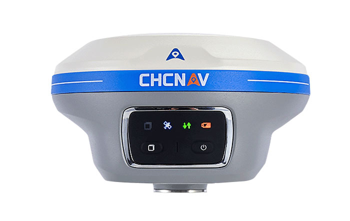
CHC Navigation (CHCNAV) has released the i89, a compact IMU-RTK GNSS receiver with visual surveying and 3D modeling capabilities. In addition to GNSS surveying, the i89 offers augmented reality surveying to capture accurate 3D coordinates where signals are obstructed or access is limited.
The i89 combines CHCNAV’s iStar2.0 software and a 1408 channel GNSS system-on-a-chip (SoC) module for full constellation tracking. According to the company, its advanced algorithms improve data quality by 20%, offering RTK accuracy and reliability even in low latitude regions with high ionospheric interference.
Based on video photogrammetry, the i89 dynamically extracts accurate 3D coordinates from real-world video. Coupled with its IMU, it is designed to improve photogrammetry efficiency and accuracy. It complements UAV surveys by resolving typical distortions from UAV-mounted cameras.
The i89 offers 16.5 hours of battery life, weighing only 750g and is IP68-rated to withstand a 2m pole drop. Its visual navigation and staking capabilities aim to simplify field operations and ensure optimal productivity for surveyors in a wide range of everyday surveying tasks.
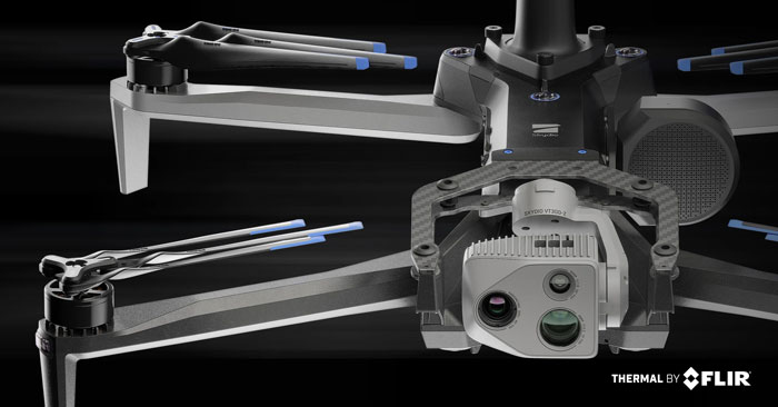
Skydio has released its X10 UAV, which features a customized Teledyne FLIR Boson+ thermal camera module. As a result of the collaboration, professional public safety and critical infrastructure inspection pilots can now easily access uncooled thermal imaging technology.
The Thermal by FLIR program is a cooperative product development and marketing program. It supports original equipment manufacturers (OEMs), such as Skydio, to integrate Teledyne FLIR thermal camera modules into products.
The Skydio X10 includes a thermal imaging payload using a customized radiometric Boson+ thermal camera module, providing thermal performance and improvements in size, weight, and power (SWaP) that are critical for inspections, situational awareness and search-and-rescue missions.
Thermal performance and SWaP enhancements
The Boson+ provides four times the thermal resolution at 640 x 512 pixels versus the predecessor thermal camera on the Skydio X2. It also doubles the thermal sensitivity of competitive payloads at 30 millikelvin (mK) or more.
Its increased sensitivity and resolution provide users with sharper scene detail, which improves detection, specifically in outdoor, low-contrast scenes — a critical need for thermal inspectors and first responders, including law enforcement officers, firefighters and search-and-rescue personnel.
Teledyne FLIR worked closely with Skydio to develop custom optics to reduce the weight of a standard Boson+ camera optics by 48%, according to the company. The weight reduction aims to help maximize flight time while decreasing the volume of the thermal camera module for an improved payload form factor.
The Skydio X10 has customized thermal image signal processing that leverages Teledyne FLIR’s Prism ISP, further improving imaging quality. The resulting thermal imagery is available as radiometric JPEGs (R-JPEG), meaning each image captured includes temperature data of every pixel in the scene for granular, quantitative insights needed for solar panel, machinery and utility inspection.
That R-JPEG data captured from the X10 can then be combined with the R-JPEG data captured from handheld Teledyne FLIR thermal imaging cameras to create comprehensive inspection reports from the air to the ground.
Skydio X10 users can also use FLIR Thermal Studio software with advanced thermal imaging processing and analysis for creating custom, sharable PDF reports.