“Seen & Heard” is a monthly feature of GPS World magazine, traveling the world to capture interesting and unusual news stories involving the GNSS/PNT industry.
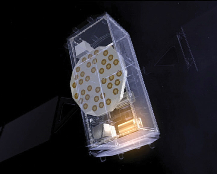
Photo: ESA
Detecting dark matter with atomic clocks
A team of researchers from Belgium’s Royal Observatory, SYRTE in Paris, the Université Côte d’Azur and the European Space Agency have used atomic clocks to search for dark matter transients in space. The team focused on a network of passive hydrogen masers (H-masers) on board the fleet of Galileo satellites to detect these transient variations. They presented a new technique that interprets fluctuations in fundamental constants as a specific kind of frequency modulation — a discrepancy in the expected times indicated by the satellite clocks. The findings are detailed in a paper titled “Searching for large dark matter clumps using the Galileo Satnav clock variations.”
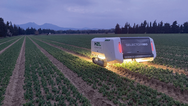
Photo: H2L Robotics
Gardening Robots
H2L Robotics has deployed fully autonomous agricultural vehicles enabled by artificial intelligence (AI) across farmlands in the Netherlands. The robots are tasked with spotting and eliminating diseased tulip bulbs ahead of the country’s financially significant spring tulip bloom. The Selector180 robot uses GNSS to autonomously drive through tulip fields, and onboard cameras to take thousands of photos. An AI model then sorts the images, looking for potentially diseased bulbs. Finally, the Selector returns to the fields and removes diseased bulbs to prevent disease from spreading.
Photo: DoorDash
Deliveries from the sky
DoorDash has expanded its partnership with Wing to bring its UAV delivery pilot to the United States. DoorDash users who are near the Wendy’s fast food restaurant located at 2355 N. Franklin Street in Christiansburg, Virginia can order eligible menu items from the restaurant. They will see the new delivery option on the checkout page. Once they select the “drone” option, their order will be prepared and delivered via a Wing UAV within 30 minutes.
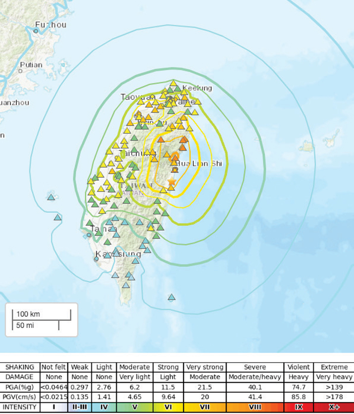
Photo: USGS
Earthquake strikes Taiwan
A 7.4-magnitude earthquake struck the eastern coast of Taiwan on April 3, according to the United States Geological Survey. USGS has released a ShakeMap providing near-real-time maps of ground motion and shaking intensity following the earthquake. According to USGS, the earthquake and aftershocks were strong enough to be felt across the island nation and parts of mainland China and Japan.
Photo: Space Surveillance Operations Center (COVE)
The Spanish Ministry of Defense has awarded a $2.9 million contract to GMV, for the development, deployment support and maintenance of the Space Situational Awareness and Control System (CCSE). The system will be used at the Spanish military Space Surveillance Operations Center (COVE).
Under the contract, GMV will conduct orbit calculation and propagation, build-up and maintenance of a space object catalog (both open and classified), prediction of atmospheric reentry, calculation of overflight events, planning of observation and sensor calibration campaigns, calculation of GNSS signal degradation and integration and processing of space weather data.
This system is expected to go into service at the end of 2024. To comply with this timeline, it will be based on GMV’s Ecosstm system, which is being used in other operational environments such as the German Armed Forces’ Space Domain Awareness Center (Weltraumlagezentrum), the civilian space surveillance systems of various other countries such as Greece and GMV’s commercial space surveillance center known as Focusoc.
The COVE, which is operated by the Ministry of Defense (MINISDEF) through its Space Command (MESPA) of the Spanish Air and Space Force (EA), was created in November 2019. The center reached its initial operational capability (IOC) in 2021.
GMV has been supporting the center and assisting its participation in the Global Sentinel exercises organized by the U.S. Space Command. As part of its support, GMV has supplied its operational orbit determination tool, Sstod, for processing data from the Spanish space surveillance radar located at the Morón Air Base, near Seville, Spain.
The European Space Agency (ESA) has selected Syntony GNSS to supply user demonstration receivers for its low-Earth orbit positioning, navigation and timing (LEO-PNT) project.
Led by Thales Alenia Space and funded by ESA, the first European LEO-PNT project aims to enhance PNT services from LEO. This initiative is expected to improve the accuracy and reliability of navigation systems, serving a wide range of applications, from critical emergency services to everyday technologies.
Syntony will provide its ground receivers, compatible with the new LEO/PNT signals, as well as with GPS and Galileo systems. These receivers will initially assess the performance of signals from the constellation, which will start with fewer than 10 satellites. There will be 100 to 600 satellites when the constellation is complete, according to Syntony.
Although the receivers may not always be able to calculate position, velocity, and time (PVT) due to the lack of available satellites, they will be essential in evaluating signal performance when at least four satellites are visible. This allows for PVT calculations and performance comparisons with existing GNSS systems.
Syntony’s software-defined radio (SDR) receivers enable real-time adjustments to the receiver settings to evaluate the constellation’s performance. This can be achieved without any hardware changes, as the LEO-PNT constellation uses frequencies similar to those used by the medium-Earth orbit (MEO) GNSS systems.
Syntony’s Constellator GNSS Simulator will be updated to incorporate the constellation’s signals as soon as they are available. This process is similar to how the signals from Xona Space Systems’ PULSAR constellation were integrated as early as 2022.
The National Oceanic and Atmospheric Administration (NOAA) has entered into a three-year Cooperative Research and Development Agreement (CRADA) with Verizon Frontline to refine the use of uncrewed aircraft systems (UAS) for assessing storm damage. This initiative aims to provide rapid and accurate damage assessments following severe weather events such as tornadoes and hurricanes.
Verizon Frontline will deploy its UAV technology to capture high-resolution imagery of areas affected by storms, providing crucial data to NOAA’s National Weather Service (NWS) and the National Severe Storms Laboratory. This imagery will assist in post-storm damage assessments and contribute to research aimed at understanding tornado behavior and improving severe weather warnings.
“Following a crisis, the initial imagery available is often from satellites, which may not offer the best resolution. Our goal with NOAA is to provide high-resolution imagery much faster, enhancing the support to emergency management and public safety agencies,” said Verizon Frontline Crisis Response Team member, Chris Sanders.
The collaboration represents a step forward in integrating modern technology into traditional environmental and emergency management practices, aiming to improve outcomes after natural disasters.
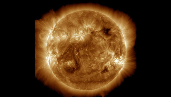
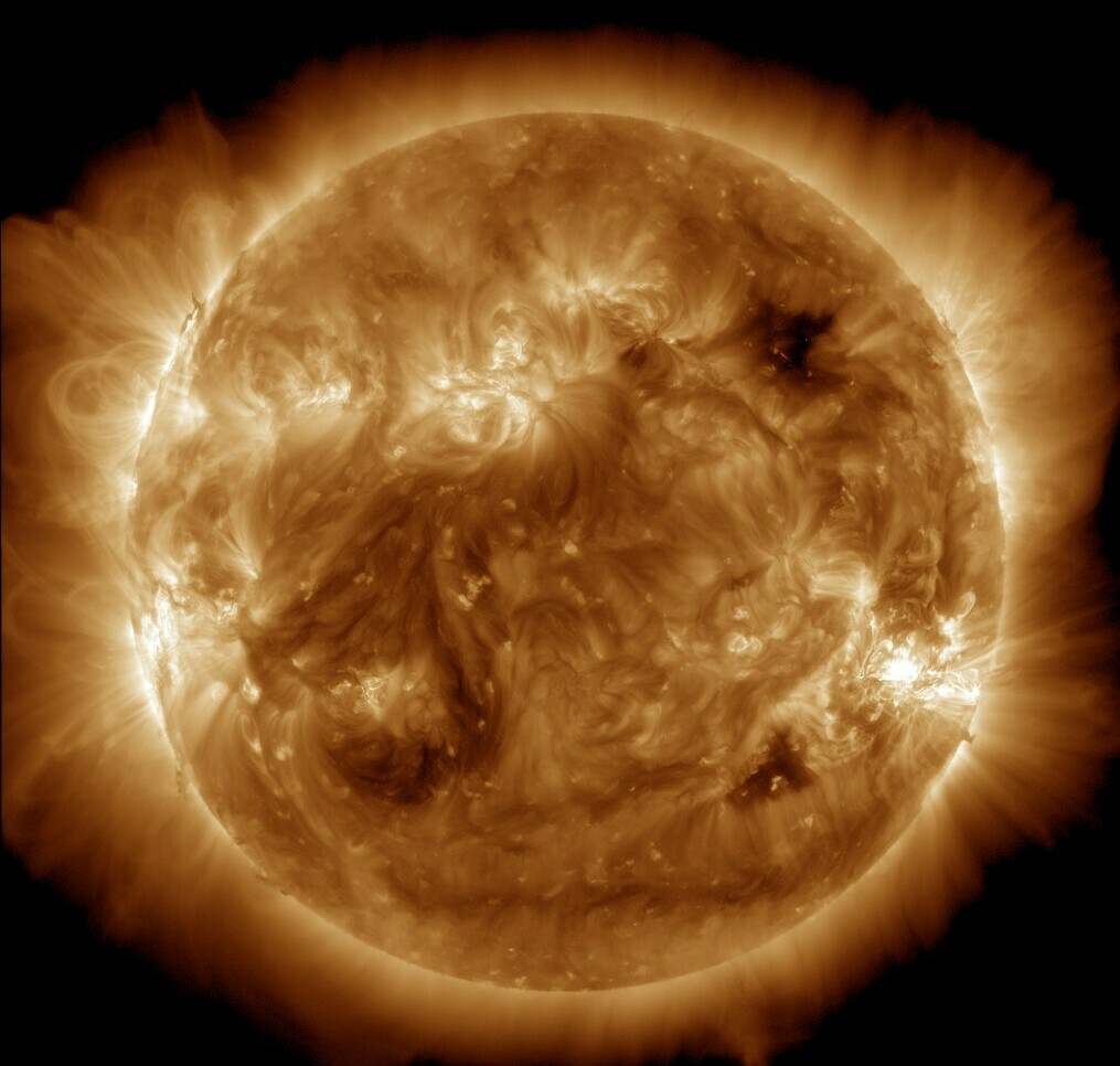
NASA’s Solar Dynamics Observatory captured this image of solar flares on May 11, 2024. The NOAA says there have been measurable effects and impacts from the geomagnetic storm. (Photo: Solar Dynamics Observatory)
Earth is experiencing a severe solar storm causing concern for those responsible for power grids, communication systems and satellites.
The National Oceanic and Atmospheric Administration (NOAA) has reported measurable effects and impacts from the geomagnetic storm that has been visible as aurora across vast swathes of the Northern Hemisphere. As of May 12, 2024, NOAA had seen no reports of major damage.
There has been some degradation and loss to communication systems that rely on high-frequency radio waves, NOAA told NPR, as well as some preliminary indications of irregularities in power systems.
“Simply put, the power grid operators have been busy since yesterday working to keep proper, regulated current flowing without disruption,” said Shawn Dahl, service coordinator for the Space Weather Prediction Center at NOAA.
“Satellite operators are also busy monitoring spacecraft health due to the S1-S2 storm taking place along with the severe-extreme geomagnetic storm that continues even now,” Dahl added, saying some GPS receivers have struggled to lock locations and offered incorrect positions.
As NOAA warned, the Earth has been experiencing a G5, or “extreme,” geomagnetic storm. It is the first G5 storm to hit the planet since 2003, when a similar event temporarily knocked out power in part of Sweden and damaged electrical transformers in South Africa.
As of May 13, NOAA’s Space Weather Prediction Center said that a G3, or “strong,” geomagnetic storm warning was in effect until 2 a.m. ET. While stronger storms are no longer likely and conditions are expected to “gradually wane” throughout the day, the center said in its forecast that moderate to strong geomagnetic storms are “likely” on May 13, as are minor storms on May 14.
The center also said that “solar activity is expected to be at high levels” with a possibility of more solar flares, or bursts of electromagnetic radiation from the sun.
The update came as another X-class solar flare was recorded. X-class flares are the strongest class of these solar bursts, and the latest was recorded as “moderate.”
Flares of this magnitude are not frequent,” the center said. “…Users of high frequency (HF) radio signals may experience temporary degradation or complete loss of signal on much of the sunlit side of Earth.”
Northern lights in unusual places
On May 12, people from all around the world shared photos of a dazzling display of the Northern Lights, which were visible in Russia, Scandinavia, the United Kingdom, continental Europe and some even reported seeing the aura as far south as Mallorca, Spain.
In the United States, the NOAA center shared that the storm-induced auroras were visible as far south as Northern California and Alabama.
The source of the solar storm is a cluster of sunspots on the sun’s surface that is 17 times the diameter of Earth. The spots are filled with tangled magnetic fields that can act as slingshots, throwing huge quantities of charged particles toward our planet. These events, known as coronal mass ejections, become more common during the peak of the Sun’s 11-year solar cycle.
While the storm has proven to be large, predicting the effects of such incidents can be difficult, Dahl said.
The world has grown more reliant on electronics and electrical systems. Depending on the orientation of the storm’s magnetic field, it could induce unexpected electrical currents in long-distance power lines. Those currents could cause safety systems to flip and trigger temporary power outages in some areas.
I took these photos near Ranfurly in Central Otago, New Zealand. Anyone can use them please spread far and wide. :-) https://t.co/NUWpLiqY2S
— Dr Andrew Dickson reform/ACC (@AndrewDickson13) May 10, 2024
The storm caused some navigational systems in tractors and other farming equipment to break down, suppliers and farmers told the New York Times.
Farmers have become dependent on equipment that utilizes GNSS and other navigation technology to help them plant more effectively — a practice known as precision agriculture. However, some of these operations in the Midwest, as well as in other parts of the United States and Canada, came to a temporary halt.
How it affects the ionosphere
The storm will also likely disrupt the ionosphere, a section of Earth’s atmosphere filled with charged particles. Some long-distance radio transmissions use the ionosphere to “bounce” signals around the globe, and those signals can be disrupted.
The particles may also refract and otherwise scramble GNSS signals, according to Rob Steenburgh, a space scientist with NOAA. Those effects can linger for a few days after the storm.
The storms can bring on ionospheric scintillation, which refers to rapid fluctuations in GNSS signal strength and phase due to localized irregularities in the electron density of the ionosphere resulting from solar activity. Scintillation adversely affects GNSS positioning, particularly around the geomagnetic equator after local sunset.
Similarly to Dahl, Steenburgh said that it is unclear just how bad the disruptions will be. While we still depend on GNSS, there are also more satellites in orbit. Moreover, the anomalies from the storm are constantly shifting through the ionosphere like ripples in a pool. “Outages, with any luck, should not be prolonged,” Steenburgh said.
Syntony GNSS has partnered with Keysight Technologies, an RF testing solutions manufacturer, to advance GNSS testing and simulation capabilities.
The collaboration centers on Keysight’s VXG advanced signal generator, which can generate thousands of simultaneous signals across all GNSS constellations and bands. It features time and phase synchronization for high fidelity and accuracy in simulation scenarios. This feature is particularly crucial for testing GNSS receivers under various conditions to ensure optimal performance in real-world scenarios.
The Syntony GNSS Simulator Constellator can mimic the complex dynamics of GNSS signals, providing a platform for testing and validating GNSS receivers. When combined with Keysight’s VXG, it serves as a comprehensive testing solution for all GNSS signals and scenarios.
The partnership aims to improve Controlled Reception Pattern Antenna (CRPA) testing. CRPA is pivotal in enhancing the resilience of GNSS receivers against interference and jamming to offer reliable operation even in adverse conditions. The combined solution from Syntony GNSS and Keysight offers a platform for testing CRPA systems to ensure they meet the stringent requirements of modern applications.
Telecommunications, among other sectors, relies heavily on precise timing information, typically derived from GNSS signals. The threat of jamming attacks, which can disrupt GPS time synchronization, poses a significant risk, potentially crippling communications and other dependent systems. The testing solutions emerging from this partnership provide a toolset for infrastructure managers to evaluate and enhance the resilience of their systems against such threats.
ipoque, a Rohde & Schwarz company and provider of deep packet inspection (DPI) software for networking and cybersecurity solution providers, has entered a technology partnership with XipLink, a global technology that provides optimized, secure and intelligent multi-path hybrid networking.
Under the partnership, ipoque will integrate its DPI technology, R&SPACE 2, into the XipLink operating system (XipOS) to create the XipLink Application Classification Engine (XipACE). This technology is designed to deliver advanced application visibility for multi-orbit networking.
Layer 7 visibility for multi-orbit networking
Using standards-based space communications protocol specifications (SCPS) protocol acceleration, link bonding, Layer 2 switching and Layer 3 routing, XipLink offers intelligent multi-orbit networking that ensures network performance and quality of service QoS across satellite, cellular and wireless networks. Embedding the next-gen DPI software R&SPACE 2 introduces traffic visibility up to Layer 7 and beyond, powering the traffic aggregation and optimization algorithms used by XipLink.
R&SPACE 2 combines behavioral, statistical and heuristic analysis with metadata extraction to identify protocols, applications and application attributes in real time.
“Our breakthrough AI-based encrypted traffic intelligence, which includes machine learning and deep learning techniques, and high-dimensional data analysis, brings traffic awareness to the next level by identifying any type of IP traffic, despite encryption, obfuscation and anonymization,” said Martin Mieth, P.hD., vice president of engineering at ipoque.
Offers high-performance networks
By integrating R&SPACE 2, XipACE can augment quality of service (QoS) management, traffic analytics, steering decisions, load balancing and dynamic link bonding. R&SPACE 2 also features an extensive feature and plug-in set, such as first packet classification, customizability of app signatures or tethering detection.
Insights from R&SPACE 2 allow XipOS to support network diversity and resilience, from offloading traffic from congested pathways to tapping into GEO satellites to alleviate latency issues. At the policy level, it enables application prioritization and SLA compliance.
As more and more applications require high bandwidth and low latency, the granular traffic analytics offered by R&SPACE 2 can help users optimize their networks and improve resource efficiency. These insights seek to lay the foundation for autonomous and self-healing networks through data-driven decision-making.
The technology is designed for mobile, satellite, maritime, government and defense sectors, as well as modem OEMs.
The Space Systems Command (SSC) Space Sensing program executive office, headquartered at Los Angeles Air Force Base in El Segundo, California, has delivered the first of two future operationally resilient ground evolution (FORGE) software deliveries to operations in the Overhead Persistent Infrared (OPIR) Battlespace Awareness Center (OBAC) at the Buckley Space Force Base in Colorado.
The integration of the FORGE framework into OBAC operations offers increased cyber resilience and enhanced mission applications to operators. OBAC operations on FORGE aim to boost OPIR battlespace awareness and technical intelligence missions with significant cyber-security improvements and enhanced missile detection and tracking.
Additionally, the operational trial period preparing for this delivery provided opportunities to stress the FORGE framework with real-world events. Notably, the framework performed in family with the legacy system, enabling the battlespace awareness and technical intelligence mission as the OBAC’s operational baseline.
FORGE provides OPIR data to operational warfighters and allows the U.S. Space Force to pivot toward a resilient missile warning, tracking and defense architecture. The FORGE ground system will support continued operations of legacy Space Based Infrared System (SBIRS), as well as the next generation of OPIR sensors including Next Gen OPIR GEO & Polar, and Resilient Missile Warning / Missile Track medium-Earth orbit (MEO) space systems. It has a cyber-resilient, flexible, scalable and government-owned open architecture to support the development, integration and delivery of OPIR processing applications for rapid response to emerging threats.
“Our nation’s ability to quickly sense and make sense of OPIR observations is crucial in maintaining decision-making advantage against adversarial threats and their advanced missile technologies,” said U.S. Space Force Col. Robert Davis, Space Force program executive officer for Space Sensing. “This effort enables target tracking earlier and for a longer duration, which significantly increases the event custody chain. Timely response to threats requires a modern architecture capable of hosting data from a range of new and legacy sensors that enables the development of applications to address these threats.”
The FORGE framework promotes open architectures designed to maximize the use of the OPIR constellation and allow for new capabilities to be added frequently and efficiently. It uses existing commercial off-the-shelf (COTS), government off-the-shelf (GOTS), and free or open-source software (FOSS) products to offer users a rapid pivot to new solutions depending on mission needs. This strategy enhances the opportunities for a broad range of vendors and strengthens the government’s access to the latest industry innovations, thereby increasing resiliency in the weapon system and industrial base, according to SSC.
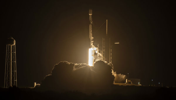
On April 27, 2024 the SpaceX Falcon 9 medium-lift launch vehicle launched into orbit Galileo satellites GM25 and FM27 from Kennedy Space Center in Florida. This was Falcon 9’s 20th and final launch.
The EU Agency for the Space Programme (EUSPA) confirmed in a statement that it is now in the Launch and Early Orbit Phase (LEOP) stage of the two new L12 Galileo satellites. They will join the current Galileo operational fleet in the upcoming months. The latest batch of Galileo satellites are being operated by EUSPA and the Galileo Service Operator for the Early Orbit Phase (EOP).
The EUSPA operations team, through its Galileo Service Operations provider, took over the satellite operations as the satellites were separated from the launch vehicle and their automated initialization sequence started. Telemetry has been successfully acquired, their solar panels deployed and the batteries are charging, bringing the satellites to what is called the Holding Point, according to EUSPA.
The EOP is a vital step in a space mission, running through the gradual activation and testing of platform satellite components, once in orbit. From the Galileo Control Centre in Oberpfaffenhofen, Germany, the dedicated LEOP team will navigate the satellites to their designated orbit within the coming days. Following rigorous in-orbit testing and commissioning, the satellites will integrate into Galileo’s operational constellation at 23,220 km.
The mission is a collaboration between the European Commission, which lead the management of Galileo; EUSPA, which manages operations and services with the support of the Galileo service operator (SpaceOpal); and the European Space Agency (ESA), which serves as the design authority, responsible for development.
NextNav has petitioned the Federal Communications Commission (FCC) to add a new spectrum solution in the Lower 900 MHz band (902-928 MHz band) to complement and backup GPS. The Lower 900 MHz band plan aims to give access to 15 MHz of low-band spectrum for 5G services.
The company filed a rulemaking petition to the FCC, proposing to rearrange the band to facilitate a terrestrial positioning, navigation and timing (PNT) network and broadband. The petition specifically asks the FCC to reconfigure the band plan and adopt new rules, including enabling a high-quality terrestrial complement and backup to GPS for essential PNT services and providing 15 MHz of low-band spectrum for use by mobile broadband networks.
The proposal, according to the filing, “enables high-quality terrestrial PNT, with the potential for widespread and inexpensive adoption in many use cases because it will use the 5G standard.” Because the company’s NextGen PNT solution uses a small amount of capacity in the 10 MHz downlink, mobile network providers can use most downlink capacity for broadband, “making the spectrum appealing for integration into existing networks and thereby accelerating the availability of terrestrial PNT services.”
According to the filing, “The 15-megahertz band plan is necessary for this broadband deployment, which enables an at-scale PNT network to be deployed efficiently, providing a unique path to resolving the coverage, cost, and user device issues that have prevented broad terrestrial PNT usage to date.”
NextNav recently signed an agreement to acquire spectrum licenses covering an additional 4 MHz in the lower 900 MHz band from Telesaurus Holdings GB and Skybridge Spectrum Foundation. In March 2024, the Superior Court of the State of California, County of Alameda, issued an Order approving the Receiver’s request to sell all of its Lower 900 MHz spectrum holdings to NextNav, allowing the parties to move forward with obtaining FCC approval.
The company plans to partner with mobile network operators or others interested in commercial deployment in the band for 5G and will ensure incumbent operations are protected. According to the company, it has used its existing licenses to develop PNT expertise and products, but, because of a legacy band plan and rules that limit the use of the spectrum for 5G, much of this band is underused.
The NextGen PNT technology and network are designed to use 5G and offer a 3D positioning solution with single-digit accuracy. The positioning solution is available indoors and outdoors and in urban corridors. It also seeks to provide wireless distribution of precise, resilient timing.
The current Lower 900 MHz Band is “not conducive for either terrestrial PNT or mobile broadband,” according to the filing, with shortcomings that include fragmented geographic licensing arrangements, outdated command-and-control requirements and other restrictions. Consolidating the geographically licensed spectrum blocks into a 15MHz nationwide configuration for both PNT and 5G broadband changes. This allows the band to support better use cases and serve as a high-performing complement and backup to GPS.
Hexagon | NovAtel has released its 7.09.01 and 7.09.02 firmware, designed to provide improved precise point positioning (PPP) accuracy and availability for ionospheric scintillation on all OEM7 receiver boards, enclosures and SMART Antennas.
Ionospheric scintillation refers to rapid fluctuations in GNSS signal strength and phase due to localized irregularities in the electron density of the ionosphere resulting from solar activity. Scintillation adversely affects GNSS positioning particularly around the geomagnetic equator after local sunset.
Ionospheric activity is increasing as the peak of Solar Cycle 25 is approaching. To mitigate these effects, 7.09.01 and 7.09.02 firmware is designed to offer substantial enhancements to the accuracy and availability of high-precision positioning during ionospheric scintillation.
Version 7.09.01 is available for agriculture applications replacing Version 7.08.15. Version 7.09.02 is available for all other markets replacing Version 7.09.00.
Data comparing the performance of 7.09.01 and 7.09.02 to previous firmware versions showed 60% improved TerraStar-C PRO PPP accuracy during periods of ionospheric scintillation and less than 90% uptime with TerraStar-C PRO PPP in scintillation regions.
Additionally, the 7.09.01 for agriculture includes Precision time protocol (PTP) available on SMART7-I and SMART7-SI for synchronizing accurate GNSS time with other devices on a shared network. Compared to the previously released Version. 7.09.00, the system shows improvements to the time to first fix (TTFF).
Users can download the firmware updates for specific platforms at https://bit.ly/3Jr8hJi
The GEODNET Foundation has received more than $2 million of strategic investments from new investors including CoinFund, Pantera, VanEck and Santiago R. Santos. The additional funds raised will support the Foundation’s near-term objectives of decentralization and developer accessibility.
GEODNET, the company’s blockchain-based global navigation network, has more than 5,000 GNSS reference stations added to its real-time kinematic (RTK) network, designed to enhance location and intelligent autonomy services. Standard GPS is typically off by two meters; however, devices connected to GEODNET’s global RTK network are designed to achieve instant accuracy within 1 cm to 2 cm.
The network can be used in agriculture, UAVs, consumer robotic devices and commercial global positioning services such as PPP precision point positioning (PPP), automotive-focused PPP-RTK services and low-Earth orbit satellite tracking.
GEODNET has more than 4,000 registered reference stations in more than 2,500 cities across 120 countries. It is designed to provide robust precision navigation systems to a variety of industries, including self-driving cars, agriculture, consumer robots, and more. An additional 2,000 stations are being delivered and installed.