An expert safety review team assembled by the Federal Aviation Administration (FAA) addressed several near-misses at U.S. airports in recent months. The group has called for “urgent action” to be taken to maintain airline safety.
The National Airspace System Safety Review Team released a 52-page report on Nov. 15, which cited air traffic control staffing shortages, technology issues and funding needs as the suspected reasons for the incidents.
The review team, which includes former FAA executives, a former National Transportation Safety Board chairman and former aviation union leaders, was established in April 2023. The group was tasked with examining the air traffic control system and delivering recommendations on how to enhance safety, according to the FAA.
Additionally, the report said that past investments in overhauling FAA technology have worsened the agency’s technology. Newer systems are being layered on top of older systems, and few of the old systems have been decommissioned or replaced, according to the report.
The old systems are becoming difficult to maintain because companies have gone out of business, spare parts are no longer available and the older workers who installed the technologies are retiring without passing knowledge onto younger employees. The equipment replacement backlog is $5.3 billion.
The panel also called for significant changes to the way air traffic controllers are trained. The report said using upgraded simulators and removing “unnecessary and outdated curriculum” could lead to faster certification and more employees.
Transportation Secretary Pete Buttigieg said the FAA is 3,000 controllers short of its goal, and according to the union representing controllers, the ranks grew by only 6% in the past year. If the current hiring plan is followed, only 200 empty seats would be filled, the report said.
The understaffing is causing controllers to work significant amounts of overtime, which the report said is causing “absenteeism, lower productivity and fatigue.”
The report comes as the National Transportation Safety Board is conducting separate investigations into several of the near collisions, one involving a near collision in Boston and a collision involving two private jets in Houston. The near misses have since caught the attention of Congress. A Senate subcommittee held a hearing on Nov. 9, where Jennifer L. Homendy, chairwoman of the National Transportation Safety Board, stressed the importance of safety checks to maintain airline safety.
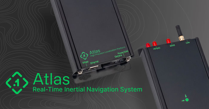
Point One Navigation has introduced the Atlas inertial navigation system (INS) designed for autonomous vehicles, mapping and other applications.
Traditional INS solutions have typically relied on extensive post-processing to reach the high precision levels needed for accurate mapping and observability applications. In contrast, Atlas can provide users with ground-truth level accuracy in real-time, which can streamline engineering workflows, significantly reduce project costs and improve operational efficiency.
Atlas is designed to be used in large fleets. It integrates a highly accurate, low-cost GNSS receiver and IMU with the Polaris RTK corrections network and Sensor Fusion algorithms. The company aims to make it easier for businesses to equip their entire autonomous fleets with high-accuracy INS.
The system features a user-friendly interface, on-device data storage and both ethernet and Wi-Fi connectivity. Field engineers can easily configure and operate Atlas using smartphones, tablets and in-car displays.
Atlas aims to drive innovation across a variety of sectors, including autonomous vehicles, robotics, mapping and photogrammetry. Its real-time capabilities and affordability can enhance the widespread deployment of ground truth-level location in fleet operations.
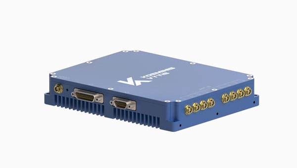
Kosminis Vytis has released two anti-jamming receivers, the KV-AJ3 and KV-AJ3-A, and an 8-channel, controlled reception pattern antenna (CRPA), anti-jamming development kit.
Image: Kosminis Vytis
The KV-AJ3 tri-band anti-jamming receiver combines a digital antenna control unit (DACU) and a GNSS receiver. KV-AJ3 can be used as a jamming protector for legacy receivers or as a stand-alone GNSS receiver solution.
When used with a Kosminis Vytis multi-band 4-channel antenna array, anti-jamming DACU uses the Null-Steering algorithm based on classic auto-compensator architecture and channel equalization, which eliminates the jamming signals from those processed by the receiver.
The tri-band solution decreases interferences from up to three directions in three frequency bands, including S-band, according to the company. This approach is designed to provide significantly higher protection against interference compared to single-frequency devices.
The receiver has a digital port for navigation data output. Jamming-free RF signals can also be delivered to external non-protected GNSS receivers to obtain position, velocity and time.
KV-AJ3 contains a MEMS inertial sensor, which allows for GNSS-aided INS solutions where coordinates and attitude angles are required.
Image: Kosminis Vytis
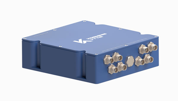
The KV-AJ3-A is designed to provide a stable navigation signal in three frequency bands, including S-band, even in the presence of jamming and other harsh conditions. The technology is MIL-STD compliant and meets the EMI/EMC requirements for avionics.
The direction to interfering signals is determined using a phased array antenna, which can then remove jamming signals from up to three directions. The original signal is either restored and delivered to external GNSS receivers or processed by the internal receiver to obtain position data. The device can be used as a DACU for legacy receivers, or as a stand-alone GNSS receiver solution.
According to Kosminis Vytis, the key components of this anti-jamming device are based on custom ASICs that allow users to achieve high jamming suppression and SWaP. KV-AJ3-A can be used for fixed installations and land, sea and air platforms, including UAVs.
Image: Kosminis Vytis
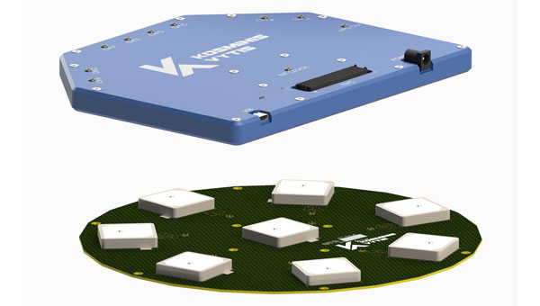
The 8-channel, CRPA, anti-jamming development kit is a set of instruments designed to help users add anti-jamming and anti-spoofing capabilities to their receivers.
The main development tool is NT1069x8_FMC — an 8-channel receiver board. The 8 coherent channels are based on NT1069, the RF application-specific integrated circuit (ASIC) that supports a high dynamic range of input signals.
Each channel performs amplification, down-conversion of GNSS signal to intermediate frequency (IF) and subsequent filtering and digitization by 14-bit ADC at 100 MSPS.
The board is compatible with GPS, GLONASS, Galileo, BeiDou, NavIC (IRNSS) and QZSS signals in L1, L2, L3, L5 and S bands. Each RF channel has an individual RF input with the option to feed power to an active antenna.
The board also has an embedded GNSS receiver and an up-converter, or modulator, which can provide connection to an external GNSS receiver.
Under a technology license, Kosminis Vytis provides users interested in developing their solutions based on the NT1069 chip with a reference design of anti-jamming receiver, anti-jamming algorithms and software tools for the development and evaluation of anti-jamming receivers.
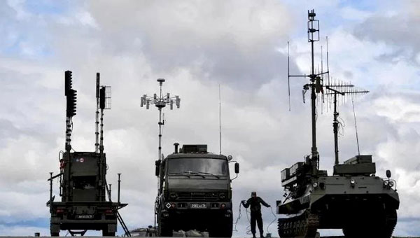
Other than the tracked unit — a truck that appears to be a power generator and has an overall look of complexity — the thing that jumps out at you about the Russian Pole-21 jammer is that it is brisling with a huge number of antennae. The system apparently can jam almost any known communication channel and everything GNSS. It is a bit lumbering to move around, may be difficult to set up, and must be used judicially, because it may jam everything, including the Russian’s own coms and GLONASS navigation systems. So, it may be useful for disabling the enemy, but only when your own soldiers have already established visual contact with their target.
The Russians just parked one of these contraptions in southern Ukraine’s Zaporizhzhia Oblast (district), which has been the focus of the Ukrainian counteroffensive for the last few months. However, the Ukrainians found it quickly, had time to figure out what to do with it and launched a GPS-guided weapon that destroyed the inoperative Pole-21 jammer. They may have caught the system either before it was fully activated or when it had been intentionally shut down to protect Russian forces. The Pole-21 set up was found during a drone recognizance flight and the system was then taken out by a Ukrainian aircraft — perhaps a Russian Sukhoi Su-27 or Mikoyan MiG-29 — which deployed a U.S. Joint Direct Attack Munition (JDAM) to destroy the system. The UAV, the aircraft, and the JDAM all use GPS for guidance, which is perhaps a little ironic. The Ukrainians have reportedly destroyed more than four dozen other Russian jamming systems since the start of the war.
Just in case there might be reprisals, the Ukrainians have developed their own RF system that forms a 600-ft dome over the area/asset that needs protection from UAV attacks. Additionally, Western countries have supplied several jamming systems to the Ukrainian forces for more elaborate, wider range jamming protection.
Ukraine initially shot down low flying, slow Russian UAVs with rifles and large caliber anti-aircraft defense systems; however, as expensive missile systems have become available from the United States and elsewhere, it has become apparent that it is too expensive to use complex missiles to bring down large numbers of inexpensive commercial UAVs. It just does not make sense — too many UAVs and not enough expensive missiles. Ukraine has thrown large numbers of cheap UAVs — some even made from cardboard — in the other direction, at a significant cost for the missiles shot at them by Moscow’s air-defense system.
Counter-UAV (C-UAV) technology must be an alternative, and several suppliers can readily provide affordable production equipment. Tactics range from firing anti-aircraft gun batteries to intercepting drones using nets, or just crashing UAVs into interlopers, or more prevalently using electronic disruption systems — such as the DroneGun Tactical “arm-held” from DroneShield — which jams the control signals and/or GNSS guidance.
A large proportion of “attack-UAVs” are simply modified off-the-shelf commercial vehicles adapted to carry explosives, even existing conventional ordinance — read “bombs”. The UAVs themselves are built with commercial components, which have little resistance to directed jamming frequencies that overpower the RF section of the receiver. Then, there is loss of lock on the coms and/or the very low power GNSS signal — where signal processing stops, and guidance is lost.
Meanwhile, back in our much safer land of commercial aviation, progress toward the emergence of electric vertical take-off-and-landing (eVTOL) air taxis took a simple step forward, at Tampa International Airport (TPA), Florida.
TPA growth plan of the Tampa airport. (Image: FAA)
TPA is in the midst of a significant growth spurt that began last year with moving the rental car facility off site to make more space and installing a rail link to restore access for renters to the main terminal. Upcoming is a new Airside D set of 16 additional gates, and future provisions for urban air mobility, enabling eVTOL air taxi traffic services in and around the airport to bring passengers directly to the airport from their local catchment areas. Possible locations have been identified for one or two vertiports on the airport grounds, and an airport integration plan appears to be well underway.
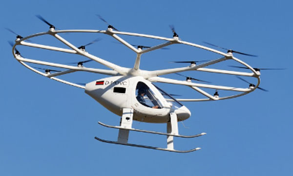
Last week, Volocopter, a German company, showed up at TPA with its VeloCity two-seater prototype air taxi to carry out the very first tests of a passenger-carrying UAM vehicle at a major U.S. airport. The Tampa and St. Petersburg mayors were on hand, as were airport management and others from the aviation and transportation industry.
VeloCity prototype in clear skies at Tampa. (Image: courtesy of courtesy BoxAdmin/Beau Zimmer/Velocopter)
Now TPA is a busy place, with 553 flights daily into and out of the facility, but Volocopter was able to fit into the infrastructure and perform two flight tests with the U.S. Federal Aviation Administration (FAA) to investigate aircraft downwash and outwash, along with aircraft performance in TPA’s actual environmental conditions.
Various prototypes of the VoloCity have already flown 2,000 flights. Initial operational flights will be flown by a pilot with only one passenger. However, as operational reliability is proven, a fully autonomous service is planned. Volocopter is currently focusing on certification of the VoloCity, by the European Union Aviation Safety Agency (EASA) in 2024, leading to initial service on three routes in Paris, France. Concurrent validation in cooperation with the FAA, originally submitted in 2020, is also progressing.
In conclusion, GNSS and communications jamming is escalating in and around Ukraine as the war drags on and each side tries to compensate, while efforts to revolutionize shuttle services for passengers to and from major airports in the United States has taken quite positive steps in Tampa, Florida.
Skydio has entered a strategic collaboration with Trimble to create an integrated workflow of accurate data capture, visualization and analytics. The workflow is designed to address the needs of critical infrastructure industries such as surveying, mapping and inspections.
The collaboration, currently in the developmental stage, aims to offer users centimeter-level accuracy in surveying and mapping projects by integrating Skydio autonomous UAVs with Trimble GNSS receivers and software. The technology can be used by construction and utility companies, as well as state transportation agencies, to streamline workflows for greater precision and project efficiency.
Industry leaders rely on autonomous UAVs with powerful visual and thermal camera sensors, such as Skydio’s X10, for their ability to capture real-time condition reports of critical infrastructure conditions. By capturing images and geospatial data early and frequently throughout construction projects, organizations can easily ensure on-site work matches the design and reduce costly rework.
When bridge or utility site inspections need to scale, the Skydio and Trimble integration can be used to collect comprehensive data and improve the necessary workflow to identify issues early and take action to prevent failures.
According to Skydio, key benefits of the collaboration include:
Automated data integration: An automated, API-based integration enables seamless transfer of aerial imagery and metadata from Skydio Cloud to Trimble Industry Cloud. It accelerates the conversion of reality-capture data into actionable insights to improve efficiency. Further refinement and analysis of the output data can be carried out in professional surveying and mapping environments such as Trimble Business Center (TBC).
Survey-grade accuracy with Skydio X10: The X10 UAV will be fully compatible with Trimble’s GNSS receivers, allowing mutual users to achieve survey-grade accuracy in mapping missions when employing Skydio alongside Trimble’s base stations and GNSS receivers. Beyond RTK, users will also be able to conduct PPK based corrections post-flight.
Vigilant Aerospace Systems, a provider of multi-sensor detect-and-avoid safety systems for UAVs and advanced air mobility (AAM), has been awarded a contract by the U.S. Air Force to develop a detect-and-avoid system for the Air Force’s new long-endurance UAV.
According to the published project description, the objective is to “integrate a mature detect and avoid capability on an existing long-endurance, Group V UAS platform, for increased aircraft and pilot-in-the-loop operational awareness that leverages new and evolving C-SWaP sensors and sensor fusion software.”
The project is sponsored by the Air Force Research Lab (AFRL) and is a Small Business Innovation Research (SBIR) Phase II project through the SBIR program. The program is designed to bring dual-use technologies, which can help both civilian and military users, into the military, with a focus on high-impact, near-term implementations.
FlightHorizon is detect-and-avoid and airspace management software that combines data from aircraft transponders, radar, UAV autopilots and live Federal Aviation Administration (FAA) data to create a single picture of the airspace around a UAV. The software displays air traffic, predicts trajectories and provides avoidance commands to the remote pilot or autopilot. The system can be used on the ground or onboard the UAV and can be configured for any size of aircraft.
The software is based on two licensed NASA patents and the company has completed contracts with NASA, the FAA and a project with the USAF’s 49th Operating Group’s MQ-9 Reaper fleet to track training flights. It is designed to meet industry technical standards and to help UAS operators fly beyond visual line-of-sight (BVLOS).
The new Air Force project incorporates prior research and development by the company in solving the automatic self-separation and collision avoidance problem for UAVs. To evaluate sensors and algorithms and establish standards-compliance and risk ratios, the company has completed hundreds of hours of flight tests with the system and thousands of simulated aircraft encounters inside the software’s built-in simulation engine, according to Vigilant Aerospace Systems.
SwissDrones, a global manufacturer and operator of long-range uncrewed helicopter systems for inspection, surveillance and public safety applications, has announced its SDO 50 V2 multi-mission, single-turbine uncrewed helicopter system has received Federal Aviation Administration (FAA) authorization.
This authorization allows aerial service provider Phoenix Air Unmanned (PAU), partner of SwissDrones, to operate the SDO 50 V2 beyond visual line of sight (BVLOS) across the U.S. This achievement marks the first-of-its-kind authorization within the United States, allowing PAU to broaden its capabilities in inspection, patrol and survey missions over extensive distances.
SwissDrones and PAU collaborated over the course of three years to build a concept of safe BVLOS operations (CONOPS) and conducted numerous flight trials in the U.S. using the SDO 50 V2. All regulatory and safety requirements were met in cooperation with the FAA to enable extended-range inspection and patrol flights over linear infrastructure under the same regulations as traditional-crewed aircraft.
PAU intends to use this aircraft for a variety of data-gathering tasks, including high-resolution imaging, lidar data collection and thermal imaging.
Depending on the specific sensor package and operating area, PUA inspection flights can span distances of more than 60 miles, allowing operators to conduct multiple inspections efficiently within a single flight.
With a maximum weight of 191 pounds, the SDO 50 V2 can carry sensors weighing between 30 and 70 pounds and maintain flights lasting over three hours. These extended flights make it ideal for missions requiring multiple sensors, offering nearly ten times the endurance and three times the lift capacity compared to aircraft weighing under 55 pounds that operate under Part 107 waivers.
The SDO 50 V2 has also received a Special Airworthiness Certificate (SAC-EC) from the FAA. SwissDrones is among the first organizations to obtain a European drone operator license, the European Union Aviation Safety Agency (EASA) Light UAS Operator Certificate (LUC). This certificate grants SwissDrones the authority to self-authorize flight operations for its aircraft across EASA countries, encompassing BVLOS operations within the specified certificate limits. Additional regulatory approvals from civil aviation authorities will be announced in the coming months.
“Seen & Heard” is a monthly feature of GPS World magazine, traveling the world to capture interesting and unusual news stories involving the GNSS/PNT industry.
Researchers in Alaska tracked the migration patterns of olive-sided flycatcher birds by attaching tracking devices to them to discover why their population is declining. The songbirds travel more than 15,000 miles every year to South America and then back to Alaska. To survive the long trips, they require safe locations to rest during their journeys. The researchers believe the stopover sites may provide an answer to the declining population. During the five-year study, the researchers deployed 95 devices and recovered only 17. The data pointed to 13 stopover sites between Washington and Peru as well as their wintering areas in South America.
Crime ring members caught
Image: hdagli/E+/Getty Images
Members of an organized crime ring in the Florida Keys who are accused of stealing more than $2.5 million in boating navigation devices have been arrested, reported Local 10.com and Fox 4. Eleven men have been accused of targeting multiple marinas throughout Florida and stealing navigation devices from boats, specifically Garmin devices. For example, a Garmin 8612 H16 Model can be sold for more than $5,000. Ten suspects are in custody and are facing more than 122 charges.
A new study published in Science used tracking devices on 43 animal species during the 2020 COVID-19 lockdowns to find that wild animals emerged from their natural habitats and ventured closer to the roads and cities that were empty. The study used several methods to analyze tracking data. Researchers examined how much animals moved on an hourly basis and during a 10-day period. Across species and countries, on average, hour-to-hour movement was 12% lower in the spring of 2020 compared to the same period in 2019. With the end of lockdowns, human activity returned to normal, and animals had to adapt again. The results of the study demonstrate how humans can change their own behavior to lessen their impact on animals.
Navigation meets creativity
Image: @vikas_ruparelia on Twitter
A man from Bengaluru, India, Vikas Ruparelia, used the Strava navigation app to trace the country of India to celebrate its Independence Day. Ruparelia started and ended his journey at the Mahatma Gandhi statue near Orion Mall in Rajajinagar, India. He covered more than 73 km on foot in 17 hours. The Strava app enables users to track their running and hiking routes as well as join challenges. The route Ruparelia took was designed by another user of the app.
DroneShield has launched SensorFusionAI (SFAI), a sensor-agnostic, 3D data fusion engine for complex environments.
In a recent release, Angus Bean, DroneShield’s chief technology officer (CTO), emphasized the shift towards a multi-sensor approach for detecting UAVs. He noted this approach is effective for fixed-site, and in some cases, vehicle and ship systems where budgets and space allow.
Bean added that the success of the multi-sensor approach hinges on the presence of an intelligent software engine to fuse the sensor outputs into meaningful data. He said without this crucial component, adding more sensors can lead to information overload without clear management.
In response, DroneShield designed an AI-based sensor fusion engine, initially integrated into its DroneSentry-C2 command-and-control system. This engine accommodates all common UAV detection modalities, including radiofrequency, radar, acoustics and cameras.
SFAI allows third-party C2 manufacturers to integrate SFAI into its C2 systems. This integration can be achieved through a subscription-based software-as-a-service (SaaS) model, enhancing system performance.
Key features of SFAI include behavior analysis to track an object to determine classification and predict trajectory; Threat Assessment that determines threat level based on a range of data types; and an edge processing device called SmartHub for reduced network load and high scalability.
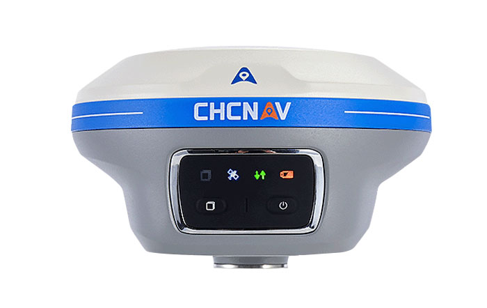
CHC Navigation (CHCNAV) has released the i89, a compact IMU-RTK GNSS receiver with visual surveying and 3D modeling capabilities. In addition to GNSS surveying, the i89 offers augmented reality surveying to capture accurate 3D coordinates where signals are obstructed or access is limited.
The i89 combines CHCNAV’s iStar2.0 software and a 1408 channel GNSS system-on-a-chip (SoC) module for full constellation tracking. According to the company, its advanced algorithms improve data quality by 20%, offering RTK accuracy and reliability even in low latitude regions with high ionospheric interference.
Based on video photogrammetry, the i89 dynamically extracts accurate 3D coordinates from real-world video. Coupled with its IMU, it is designed to improve photogrammetry efficiency and accuracy. It complements UAV surveys by resolving typical distortions from UAV-mounted cameras.
The i89 offers 16.5 hours of battery life, weighing only 750g and is IP68-rated to withstand a 2m pole drop. Its visual navigation and staking capabilities aim to simplify field operations and ensure optimal productivity for surveyors in a wide range of everyday surveying tasks.
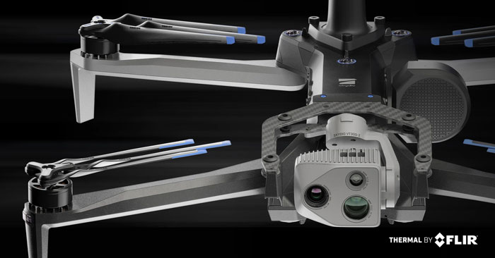
Skydio has released its X10 UAV, which features a customized Teledyne FLIR Boson+ thermal camera module. As a result of the collaboration, professional public safety and critical infrastructure inspection pilots can now easily access uncooled thermal imaging technology.
The Thermal by FLIR program is a cooperative product development and marketing program. It supports original equipment manufacturers (OEMs), such as Skydio, to integrate Teledyne FLIR thermal camera modules into products.
The Skydio X10 includes a thermal imaging payload using a customized radiometric Boson+ thermal camera module, providing thermal performance and improvements in size, weight, and power (SWaP) that are critical for inspections, situational awareness and search-and-rescue missions.
Thermal performance and SWaP enhancements
The Boson+ provides four times the thermal resolution at 640 x 512 pixels versus the predecessor thermal camera on the Skydio X2. It also doubles the thermal sensitivity of competitive payloads at 30 millikelvin (mK) or more.
Its increased sensitivity and resolution provide users with sharper scene detail, which improves detection, specifically in outdoor, low-contrast scenes — a critical need for thermal inspectors and first responders, including law enforcement officers, firefighters and search-and-rescue personnel.
Teledyne FLIR worked closely with Skydio to develop custom optics to reduce the weight of a standard Boson+ camera optics by 48%, according to the company. The weight reduction aims to help maximize flight time while decreasing the volume of the thermal camera module for an improved payload form factor.
The Skydio X10 has customized thermal image signal processing that leverages Teledyne FLIR’s Prism ISP, further improving imaging quality. The resulting thermal imagery is available as radiometric JPEGs (R-JPEG), meaning each image captured includes temperature data of every pixel in the scene for granular, quantitative insights needed for solar panel, machinery and utility inspection.
That R-JPEG data captured from the X10 can then be combined with the R-JPEG data captured from handheld Teledyne FLIR thermal imaging cameras to create comprehensive inspection reports from the air to the ground.
Skydio X10 users can also use FLIR Thermal Studio software with advanced thermal imaging processing and analysis for creating custom, sharable PDF reports.
Skydio has released the Skydio Remote Flight Deck, a new feature that allows remote control of Skydio X10 UAVs through a web browser over cellular networks. The remote flight deck offers an easy transition of flight control between local and remote pilots to continuous situational awareness via live streaming.
This solution allows operators to command UAVs from either indoors or outdoors, which can benefit public safety, utilities, construction, and transportation sectors.
When rapid response is crucial — such as in law enforcement activities, search and rescue operations or firefighting — UAVs can offer faster, more effective reactions. They can expedite infrastructure assessments, assist in determining recovery priority levels and ensure community safety.
The Skydio Remote Flight Deck allows for faster UAV deployment compared to traditional emergency response vehicles. In potentially dangerous scenarios, a ground officer can delegate flight control to a remote pilot, ensuring localized situational awareness.