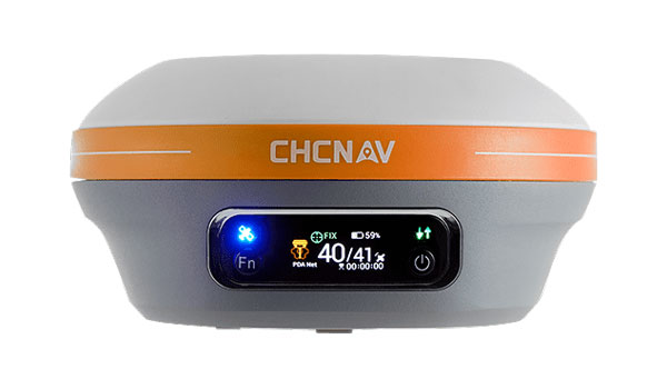
Swift Navigation has collaborated with CHC Navigation (CHCNAV) to integrate Swift’s Skylark Precise Positioning Service with CHC Navigation’s GNSS receivers.
Skylark is a cloud-based GNSS corrections service designed to improve the accuracy of standard GNSS from several meters to a few centimeters. Built to meet stringent standards for automotive safety (ISO 26262), Skylark supports more than 10 million advanced driver-assistance systems (ADAS)-enabled and autonomous vehicles globally. It can be used in a variety of applications, such as autonomous vehicles, robotics and surveying equipment.
Example integration
The CHC CGI-220 Pro is a high-precision, automotive-grade GNSS/INS tightly coupled navigation system designed for applications requiring robust and accurate positioning, such as autonomous driving, ADAS and intelligent transportation systems. When integrated with Skylark, the CGI-220 Pro offers:
Centimeter-level accuracy: Skylark enhances the CGI-220 Pro’s precision, delivering reliable, real-time positioning even in challenging environments.
Seamless integration: The CGI-220 Pro’s compact design and compatibility with various vehicle systems allows for straightforward integration into automotive platforms.
High reliability: Engineered to meet stringent automotive standards, the CGI-220 Pro offers consistent performance under demanding conditions.
A roundup of recent products in the GNSS and inertial positioning industry from the November 2024 issue of GPS World magazine.
OEM
High-Dynamics MEMS Gyro Designed for precision navigation applications
The GYPRO4300 is a high-dynamics MEMS gyro designed for precision navigation applications. It features a ±300 °/s input range, 200 Hz bandwidth and 1 ms latency, making it ideal for dynamic environments. With a bias instability of 0.4 °/h and an angular random walk of 0.07 °/√h, the GYPRO4300 offers high-performance sensing in a compact, digital and low size, weight and power (SWaP) package.
Building on the GYPRO4300, the GYPRO4050 is a specialized north-seeking gyro for low-dynamics applications. This derivative offers 2° azimuth accuracy and is currently in the customer sampling stage. The GYPRO4050 maintains the same miniature package design as its predecessor, ensuring consistency across the product line.
At INTERGEO 2024, TDK showcased a prototype based on an ongoing research and development project. This new development utilizes the same miniature package as the GYPRO4300 and GYPRO4050 but demonstrates ultra-low noise capabilities, achieving an azimuth accuracy of less than 1°. This product is slated for launch in 2025.
This series of anti-jamming antennas comes in two models, PT023 and PT024. The antennas are specifically engineered to operate in challenging environments characterized by complex electromagnetic interference, high-power signals and strong multipath effects.
They are well-suited for scenarios involving low-elevation angle interference, high-power interference sources and radio communication system noise. The PT023 model utilizes multiple array elements combined with amplitude and phase manipulation to achieve spatial radiation shaping. This antenna also incorporates advanced multi-level filtering technology, effectively suppressing out-of-band noise power.
The PT024 model features vertical and horizontal two-dimensional polarization suppressors. This design effectively mitigates the reception of both odd and even LHCP and RHCP signals originating from the rear of the antenna, according to the company. It can also suppress low-elevation multipath signals at the same frequency and out-of-band noise signals. These features seek to enhance the antenna’s performance in complex electromagnetic environments.
Triple-Band RTK Receivers Integrated into ArduSimple’s evaluation boards
The UM980, UM981 and UM982 RTK modules are integrated into the ArduSimple simpleRTK3B series to accelerate high-precision GNSS integration. Supporting Galileo High Accuracy Service (HAS) and fast update rate (50Hz), these devices are suitable for applications that require reliable and precise navigation.
SimpleRTK3B Budget (UM980): The most affordable step into triple-band precision.
SimpleRTK3B Fusion (UM981): Ideal for projects that need GNSS and inertial measurement unit (IMU) sensor fusion or tilt compensation.
SimpleRTK3B Compass (UM982): Designed for setups requiring dual antennas to determine the heading on moving platforms.
ArduSimple has also integrated Unicore UM980, UM981 or UM982 modules into the simpleRTK3B Micro Unicore, part of its compact Micro-format lineup. It is designed for simple PCB integration, which can significantly speed up the development process and the time to market for new products.
The HX-SE402A and HX-SE403A are full-band, full-frequency antennas that integrate GNSS capabilities with a low-profile radio antenna to support 858-878MHz and 902-928MHz frequency bands. This addresses the growing need for devices requiring both navigation and communication functionalities. Harxon’s new low-profile technology achieves the same functionality at 10 mm height, allowing greater versatility in applications that demand precise positioning alongside wireless communication. Additionally, Harxon offers custom tuning services to optimize integration into OEM end-user modules for specific applications.
Advanced Navigation has expanded its Certus product line by introducing the Certus Mini series. This development marks a significant advancement in compact and high-performance navigation technology for field robots, autonomous vehicles and UAVs.
The Certus Mini series comes in three variants:
Certus Mini D: A dual-antenna inertial navigation system (INS).
Certus Mini N: A GNSS-aided INS.
Certus Mini A: An attitude and heading reference system (AHRS).
These lightweight systems, weighing no more than 55 grams (1.9 oz), offer impressive performance and cost-efficiency for their size. The Certus Mini D utilizes dual-antenna GNSS for accurate heading, position and velocity measurements. It operates on L1/L5 multi-constellation GNSS and offers enhanced interference immunity and position accuracy, particularly in challenging urban environments. The Certus Mini series suits various applications, including surveying, agricultural robotics, open-pit mining and asset tracking.
Direct Georeferencing Solution Designed for UAV mapping
The APX RTX portfolio is a new line of direct georeferencing solutions designed for UAV mapping sensors. This system enables high-accuracy mapping across diverse environments, ideal for OEMs and UAV payload integrators. At the core of the APX RTX portfolio is the Trimble CenterPoint RTX technology, which offers both real-time and post-mission direct georeferencing. This capability allows for centimeter-level accuracy without the need for base stations, making it compatible with various sensors, including cameras, lidar and hyperspectral mapping devices.
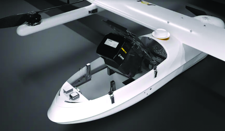
The DT46 lidar UAV is a fixed-wing system designed for long-distance inspections and the creation of precise digital twins. The DT46 model integrates the YellowScan Voyager lidar with a high-resolution RGB camera. Equipped with a laser scanner with a 100° field of view and an acquisition rate of up to 2400 kHz, the YellowScan Voyager offers optimal point density for demanding projects.
With a flight range of up to 300 km, depending on whether vertical take-off and landing (VTOL) or catapult take-off is employed, the UAV is designed for long-distance operations and can be deployed in under 15 minutes without requiring specialized tools. This autonomous solution offers a seamless end-to-end solution for various industries requiring aerial surveying and inspection capabilities.
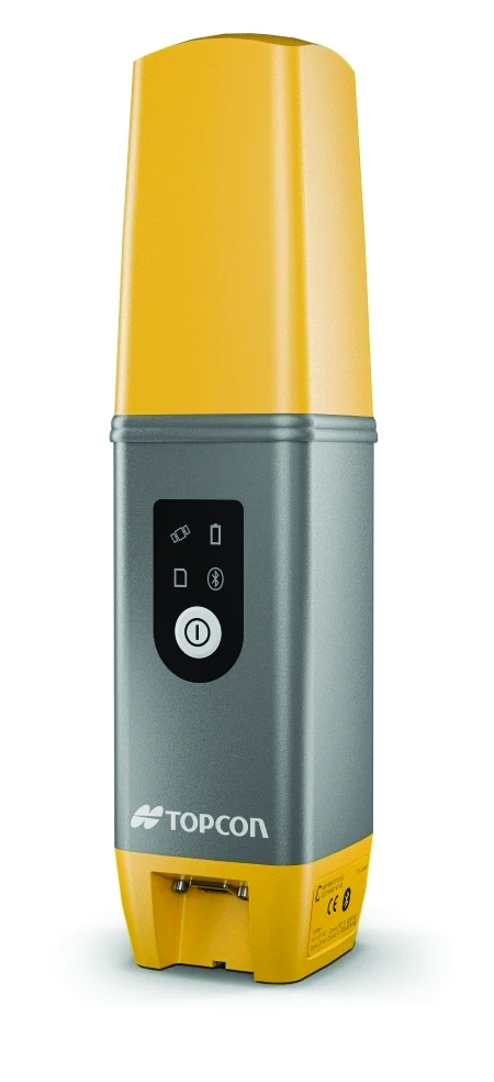
GNSS Receiver Featuring a multi-constellation antenna
The Stonex S900 GNSS receiver features a high-accuracy, multi-constellation antenna, a powerful UHF transmitter and the GSM 4G modem for a fully integrated communications choice, combined with a light and modern design. It tracks signals from GPS, GLONASS, BeiDou, Galileo and QZSS satellites. On the S900, two smart hot-swappable batteries can be inserted simultaneously, ensuring a maximum of 12 hours of operation. The power level can be checked and seen on the controller or directly on an LED bar on the battery.
The HydroBoat 1500 is a versatile unmanned surface vessel (USV) driven by four powerful thrusters and designed to carry out underwater topographic surveys of lakes, rivers, reservoirs and other bodies of water. With a payload capacity of 60 kg, it can be integrated with the SatLab HydroBeam M4 portable multibeam echosounder, as well as a variety of other payloads such as side scan sonars and ADCPs. The vessel is IP67-rated and includes a millimeter-wave radar and 360° omnidirectional camera for accurate obstacle detection and safe navigation. It is also equipped with a dual RF and 4G cellular communications system.
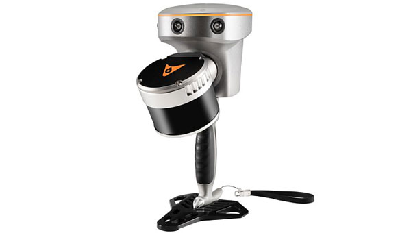
The Jupiter Laser RTK integrates GNSS, auto-IMU (inertial measurement unit), laser and dual-camera systems into a single unit. It incorporates a precise green laser that remains visible even in bright daylight. This feature allows for precise measurements of points in hard-to-reach, signal-blocked or potentially hazardous locations. It also features a night vision camera, allowing users to see feature points even in low-light conditions.
The RTK system’s laser range is up to 50 m, making it suitable for challenging surveying environments. It incorporates visual technology to offer surveyors an immersive experience during surveying and stakeout operations, improving working efficiency and productivity.
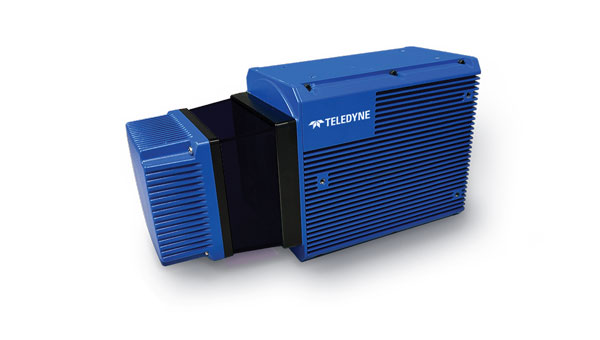
EchoONE combines Teledyne’s lidar and camera technology with Inertial Labs’ remote sensing payload instrument (RESEPI). EchoONE is designed for industries requiring precise aerial surveying and mapping solutions, such as land surveying, electric utility vegetation management, asset modeling, as well as transportation and infrastructure projects. Users can create detailed 3D models for infrastructure and asset management, offering valuable insights for maintenance and planning. EchoONE also generates fully undecimated georeferenced point clouds in real time, which allows for in-field verification. This capability is complemented by rapid post-processing through RESEPI’s “one-click” PC-Master Pro solution.
The i83 Pro is an inertial measurement unit (IMU) real-time kinematic (RTK) GNSS receiver. This receiver combines GNSS capabilities with extensive compatibility options to address the diverse needs of surveying, construction, and mapping professionals. It incorporates CHCNAV’s third-generation GNSS antenna and the latest iStar algorithm, designed to boost GNSS signal tracking efficiency by 30%, according to the company. With 336 channels supporting GPS, GLONASS, BeiDou, Galileo and QZSS constellations, it can achieve centimeter-level precision rapidly, even in challenging environments.
The i83 Pro supports various GNSS surveying modes, such as RTK Networks NTRIP and UHF base-rover configurations. It features an IP68-rated enclosure for dust and water protection, a compact and lightweight design for enhanced portability, a high-resolution color display for clear status information and a 20-hour battery life for continuous operation in rover mode.
LP360 Land is designed to process lidar, GNSS and SLAM data from handheld sensors, particularly the TrueView GO handheld scanner. It features a GIS interface that allows users to combine various geospatial datasets and offers SLAM point cloud processing capabilities. Additionally, LP360 Land includes advanced visualization tools that support multiple synchronized windows for 2D, 3D, profile and immersive views.
Its coordinate system management includes datum and projection transformations. The software also offers quality assurance and control (QA/QC) tools, along with data editing and cleaning functionalities. Users can perform manual and automatic registration of point clouds and utilize an image explorer for contextual analysis by linking point clouds to photos, which allows for the generation of accurate and colorized point clouds even in GPS-denied environments.
CHC Navigation (CHCNAV) has unveiled the i83 Pro, an inertial measurement unit (IMU)-real-time kinematic (RTK) GNSS receiver. This receiver combines GNSS capabilities with extensive compatibility options to address the diverse needs of surveying, construction and mapping professionals.
The i83 Pro incorporates CHCNAV’s third-generation GNSS antenna and the latest iStar algorithm, designed to boost GNSS signal tracking efficiency by 30%, according to the company. With 336 channels supporting GPS, GLONASS, BeiDou, Galileo and QZSS constellations, it can achieve centimeter-level precision rapidly, even in challenging environments.
The receiver offers comprehensive connectivity options, including built-in Wi-Fi, Bluetooth, NFC, 4G modem and UHF modem. These technologies support various GNSS surveying modes, such as RTK Networks NTRIP and UHF base-rover configurations. The i83 Pro is compatible with VRS, FKP and MAC for Network RTK for precise positioning across diverse operational settings.
Engineered for challenging environments, the i83 Pro features an IP68-rated enclosure for dust and water protection, a compact and lightweight design for enhanced portability, a high-resolution color display for clear status information and a 20-hour battery life for continuous operation in rover mode.
The i83 Pro offers optional Trimble RTX and OmniSTAR support, providing RTK-level accuracy without relying on a base station or VRS network. Additionally, it can be equipped with the optional Trimble MAXPro Positioning Engine for extended performance.
CHCNAV will showcase this receiver at INTERGEO 2024 in Hall 3, Booth B3.052.
Change from one generation of GNSS receivers to the next is generally evolutionary, not revolutionary. As with other technologies, it follows a feedback loop between end-user requirements and technical advances. Additionally, GNSS receivers can now take advantage of four full GNSS constellations, two regional ones, and a plethora of corrections/augmentation services — and increasingly must be able to counter jamming and spoofing.
To get the perspective of GNSS receiver manufacturers on these issues, I asked four questions to the following company representatives:
For longer versions of their responses, as well as responses from additional companies, visit here.
Question: What is currently the best way to take full advantage of the large number of GNSS satellites — four full constellations and two regional ones — and of the many corrections/augmentation services?
Korsakissok: Many satellites in view means greater precision in urban areas, where the view of the sky is partially masked, better resilience to adversity (jamming, spoofing, constellation disruption) and, more generally, greater precision even with a clear view of the sky, thanks to local augmentations. Users working on autonomous vehicles are asking for these advantages, with the goal of achieving a certified and secured system. Technically, to have an optimal usage of this multiplicity of satellites and signals, a receiver should be able to make a fix, even with one or two satellites of each constellation in view, as we do at Syntony. Practically, because of the heritage, it is not so often the case: Many receivers, even today, make a position, velocity and time (PVT) calculation with GPS first and then use the other signals to improve it.
Lopez: To fully leverage all GNSS constellations and regional systems, it is essential to utilize multi-constellation and multi-frequency receivers that significantly enhance accuracy and reliability. These advanced receivers not only improve performance by accessing a broader range of satellite signals but also ensure consistent positioning in challenging environments, such as urban areas with tall buildings or rural regions with obstructed views of the sky.
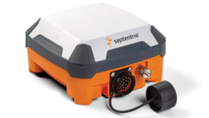
Septentrio’s antarx is a rugged GNSS/INS multi-frequency smart antenna. (Photo: Septentrio)
Some GNSS manufacturers limit signal usage due to inadequate hardware that cannot track multiple signals and their desire to reduce costs (e.g., CPU power or the number of signal tracking components). Effectively tracking multiple signals and constellations necessitates a robust hardware architecture as well as efficient algorithms that can operate optimally in compact embedded systems to fully leverage all available signals in space. At Septentrio, we prioritize maximizing all available signals to deliver the best possible performance for users while ensuring that our solutions remain valuable and accessible for a variety of applications.
Utilizing multiple GNSS signals not only enhances accuracy, availability, and reliability but also improves resilience and GNSS security, offering crucial protection against jamming and spoofing — issues that are becoming increasingly critical for many applications. Moreover, manufacturers must prioritize compatibility with various correction systems, which provide real-time data to improve positional accuracy further. Ensuring that receivers can seamlessly integrate with multiple correction services allows for smooth adoption across diverse market applications, catering to the unique needs of different industries.
To meet market demand, Septentrio has developed the Agnostic Corrections program, enabling customers to select from a range of well-established and affordable correction services. This approach offers flexibility and access to key service providers in the industry. Since these services support various signals, the advantage of our receivers is key to accommodate the wide array of signals and format messages used by these correction services.
At Septentrio, optimizing these elements is central to our vision and strategy for GNSS core technology. By focusing on performance, reliability, and compatibility, we aim to deliver innovative solutions that meet the evolving demands of the market while maintaining our commitment to excellence in GNSS technology. This strategic approach not only enhances the user experience but also positions Septentrio as a leader in the GNSS field.
Wang: To fully benefit from commercial PPP corrections, receivers must be capable of receiving signals from all GNSS constellations and frequency bands, and support SBAS and L-band services. On the software side, optimizing GNSS satellite utilization involves feeding the navigation filter with a wide range of observations from each available constellation. This, combined with adaptive interference mitigation algorithms and receiver autonomous integrity monitoring (RAIM) techniques, can greatly enhance the robustness and resilience of GNSS solutions in challenging environments such as urban canyons, interference, and spoofing.
Farrokhi: Regional services are categorized as augmentation systems. They are offered through both satellites and terrestrial systems. Satellite-based augmentation systems include but are not limited to SBAS, WAAS, AGNOS, MSAS, GAGAN, NavIC and QZSS. Terrestrial augmentation systems include but are not limited to GBAS, and GLS. Correction services include but are not limited to RTK and PPP.
Supporting these regional and correction services along with multi-band support increases the complexity of the receiver hardware and associated firmware. It is important to note that not every application or use case requires all these different services. For instance, asset tracking utilizing battery-operated tags do not require correction services or L5 acquisition. Low-power operation and simplicity of the GNSS receiver is key to longevity of operation in such applications.
The selection of correction service is highly dependent on the type of communication pipe supported by the hardware. For instance, L-band capability is required for satellite-based correction services, whereas LTE is needed for terrestrial based services.
Ching: I think one of the best ways is to embrace all the available signals on hand. What that means is with the luxury of redundancy, the system can select the best signals to use into the position estimation algorithm. Our OEM7 uses multiple constellations (GPS, GLONASS, Galileo, BeiDou, QZSS and NavIC) and multiple frequency bands (L1, L2, L5 and E6).
Q: Are the requirements for different end user applications — for example, surveying vs. fleet tracking — still very different or are they converging as capabilities increase?
Cerber CRPA Receiver with four-channel antenna and Constellator CRPA simulator. (Photo: Syntony)
Korsakissok: In a way, everybody is benefiting from better precision year after year, using the standard open signals; related to that, we can say that the solution capabilities are converging. A bit. However, we do not see everybody converging toward a “high precision real-time PVT every time everywhere.” Bringing 20-cm precision to a truck-tracking application is nice, but nobody will ever want to pay for this, if it is not relevant for how they use the application. Conversely, for precision agriculture, precision mining and autonomous vehicles, it will always be required, and they will be able to pay for the precision, when associated with reliability, in order to achieve the targeted level of safety.
Lopez: Although GNSS technology has evolved significantly in recent years due to the growing demand for accuracy across new applications, the requirements among different applications remain highly varied. Some may need centimeter-level precision, while others are satisfied with accuracy within 10 centimeters. Survey-grade applications still demand millimeter-level accuracy, while certain autonomous systems may only require 1 to 10 centimeters of precision. Additionally, the environments in which these applications operate vary, such as a surveyor working in unobstructed ground conditions versus a drone navigating through complex airspaces, where jamming, signal availability, and interference can affect performance.
The increasing number of applications that rely on accuracy has resulted in diverse requirements across the board. This is why customers seek more flexible GNSS receivers to balance availability, accuracy, and reliability based on the specific use case. There’s a broad spectrum of needs — not only in GNSS performance (accuracy, time to fix, reliability) but also in security (anti-jamming, anti-spoofing, cybersecurity) and hardware design. For example, some users need compact solutions for small form-factor devices, while others prefer robust systems that can endure harsh environmental conditions. A surveyor, focused on achieving high accuracy, may not need the same GNSS resilience required by critical infrastructure or autonomous systems, where safety mechanisms are crucial.
As more prosumer and innovative applications advance, their needs differ from those of industrial or critical-use cases. At Septentrio, we offer solutions that fill the gaps when lower-end options fall short, attracting customers dissatisfied with third-party products that fail to meet their needs. Septentrio also provides enclosure solutions with stringent environmental protection requirements, including water resistance, humidity control, vibration tolerance, and corrosion resistance.
While GNSS technology continues to advance and become more sophisticated, we also see that the gap between different applications is narrowing. Fleet tracking, for instance, is beginning to benefit from more precise positioning and the ability to use multiple GNSS constellations for autonomy — features traditionally reserved for high-precision applications such as surveying. The cost of high-precision GNSS receivers is also decreasing, making advanced features more accessible across various industries.
However, this increased autonomy introduces new demands, such as top performance and safety in complex environments, and seamless integration with sensor fusion and other ecosystems. Traditional GNSS receivers used for basic fleet tracking will not meet the needs of these advanced use cases, even if they remain part of the same vehicle or platform.
In summary, despite a trend toward the convergence of GNSS capabilities that enhance accuracy, the core requirements of these applications remain distinct, challenging the industry to develop more universally applicable solutions.
Wang: From our point of view, while GNSS performance is steadily improving, manufacturers still need to strike a balance among cost, accuracy, and availability to meet the diverse requirements of different user applications. In surveying, for example, accuracy is the top priority, while in transient control, integrity and availability are more critical. Although GNSS capabilities are increasing and some convergence of requirements is occurring, significant differences remain, necessitating careful design and optimization by manufacturers to address these varying needs.
Farrokhi: The requirements for surveying, for instance, do not apply to the rest of the market. For surveying, extreme accuracy is a must, hence utilizing RTK services and the cost of the solution is usually high. On the other hand, asset tracking, for instance, can benefit from high sensitivity, low power, low cost and cloud processing to reduce power consumption in the asset tracking device.
Generally speaking, the GNSS market falls into the following categories:
Low power, low cost — such as asset tracking
High precision — e.g., surveying and agriculture
High precision, with high reliability — such as ADAS
High speed, high G — in defense applications
Anti-jamming and anti-spoofing — such as in avionics and defense
etherWhere’s next generation hardware solution enables the convergence of all these disparate applications onto one hardware platform by utilizing flexible software and cloud processing.
Ching: Ultimately, regardless of applications, users want the reported positions that are accurate with trustworthy quality indicators. As capabilities increase, I expect more requirements to converge. For example, both surveying and fleet-tracking applications need to operate during ionospheric scintillations. Having a robust positioning solution in both applications is essential. Hexagon | NovAtel released updated firmware (versions 7.09.01 and 7.09.02) in April 2024 to increase ionospheric resilience.
Q: What is the best way to integrate complementary sources of PNT — such as LEO satellites and ground-based systems — into end user hardware and software, to maximize resilience during GNSS disruptions or outages?
Korsakissok: Such integration will be eased for all the new sources that can be acquired with the same RF stages, meaning mostly L-band as of today. SBAS has paved the way and emits at the same carrier frequency as the classic GNSS. U.S. and European low-Earth orbit positioning, navigation and timing (LEO-PNT) projects have included such signals in L-bands, and other telecom constellations can also be used that way (Inmarsat, Iridium, etc.). Because of this, all these L-band extensions to classical GNSS will be the first in line on everybody’s roadmap. When C-band signals will be emitted by GNSS constellations, then telecom ones could also be easily integrated. However, that will take many years.
Lopez: To enhance resilience during GNSS disruptions or outages, integrating a multi-layered approach with complementary sources of positioning, navigation, and timing (PNT), such as LEO satellites and ground-based systems, into end-user hardware and software is crucial. While GNSS technology will remain essential, the combination with other technologies such as inertial sensors and sensor fusion will become increasingly important as these solutions become more available.
Although alternative PNT mechanisms can bolster resilience, the strengths and protections at the core of GNSS are vital for many applications, especially since GNSS manufacturers possess the expertise to address jamming and spoofing effectively. This layered security approach resembles the “onion model” in cybersecurity — adding more security layers enhances protection against disruptions.
While LEO technology is advancing, its full value for PNT may take a few more years to materialize. In the meantime, other sensor technologies, such as inertial navigation systems (INS), already provide significant benefits in the absence of GNSS or in the most difficult conditions to GNSS.
At Septentrio, we are committed to developing products that invest in sensor fusion technologies (GNSS/INS), and we actively participate in key LEO programs that promise substantial improvements in resilience and other PNT aspects, including GNSS corrections and enhanced multipath mitigation for optimal performance in challenging environments. We view this evolution as critical to our product roadmap and consider it a strategic priority for our company.
Wang: The foundation of an effective positioning system is robust hardware that supports the integration of multiple PNT sources. Building on this multi-source signal base, a set of advanced algorithms is necessary to selectively use the signals and filter out interference, enabling the seamless fusion of these sources and achieving superior performance. Moreover, redundant and backup filters are crucial for maintaining the robustness of the positioning solution, particularly during GNSS disruptions or outages.
Farrokhi: etherWhere’s next-generation solution supports LEO constellations such as Xona Space to enhance location tracking and provide resilience and redundancy. LEO satellites signal strength is higher than GNSS satellites due to their lower orbit and as such provide better link margin. The key to ubiquitous adoption is in a well-integrated single chip solution at lower power consumption.
Ching: Complementary sources of PNT must be proven to provide a consistent improvement in positioning performance, beyond what GNSS alone can provide. For example, increasing availability is not helpful if the quality indicators cannot be trusted. The integration must be an overall benefit to the user, in terms of ease of use, positioning performance and reliability. Our team is already leading the market and working with key stakeholders and partners to provide PNT beyond GNSS as we announced in previous years.
Q: What are the key innovations in your latest receiver or generation of receivers?
Korsakissok: Syntony is well-known to have one of the first full SDR embedded receivers, working in multi-frequency and multi-constellation mode. Thanks to that, we were able to be the first to demonstrate the coupling with XONA, at ION GNSS in 2022, and have been chosen by the European Space Agency (ESA) for their own LEO PNT: Flexibility and ease of modification are the major advantage of full SDR, versus ASICS.
Today, our SDR receiver is embedded in cars, trains, UAVs, launchers and satellites, but also in trucks for underground mining, together with our SubWAVE solution. Not to mention our CRPA version, which is capable of state-of-the-art anti-jamming level, completed by exclusive anti-spoofing mitigation, as we can compare, directly inside the receiver, the direction of arrival of all GNSS signals with the ephemeris, avoiding retaining and tracking the ones that are spoofed.
Lopez: This year, Septentrio has achieved notable advancements in GNSS receiver technology by enhancing resilience against jamming and spoofing and by launching the AntaRx product line. It offers high-precision performance, a durable design, and versatility for industrial applications, such as construction and mining. With advanced anti-jamming and anti-spoofing across all products, plus the AntaRx — which is an all-in-one GNSS, antenna, and sensor fusion solution — we remain committed to delivering the most reliable positioning in the most challenging environments.
Lopez: In response to evolving market demands and guided by our strategic vision, Septentrio has made significant advancements in GNSS receiver technology, focusing on two major pillars: resilience and performance.
Resilience: Septentrio has established a reputation for providing robust GNSS solutions thanks to our AIM+ technology, and we remain committed to enhancing resilience across our product line. Our latest innovations have significantly improved our receivers’ ability to detect and mitigate spoofing attacks. These enhancements have been validated through rigorous testing, including recent GNSS jamming tests conducted in Norway (see Norway results here), as well as field applications where our receivers have successfully operated in contested environments, particularly within drone applications. This continued focus on resilience ensures that our customers can rely on our technology even in challenging conditions where signal integrity is paramount.
AntaRx Product Portfolio: This year, we proudly launched the AntaRx product line, specifically designed to meet the rigorous demands of industrial applications such as construction, mining, and robotics. The AntaRx series offers a variety of configurations, including single-frequency, dual-frequency, and inertial variants (GNSS/INS), providing unparalleled flexibility for a wide range of use cases (see more about this product here).
What sets the AntaRx apart is its exceptional high-precision GNSS performance combined with core reliability. This product line is compatible with various correction services, allowing users to achieve optimal accuracy regardless of their operational environment. Moreover, the AntaRx features advanced anti-jamming and anti-spoofing technologies, which are critical for ensuring the integrity of positioning data in areas where interference is prevalent.
In addition to its technological innovations, the AntaRx is designed with ruggedness in mind. It is built to withstand harsh environmental conditions, making it suitable for deployment in demanding industries. The user-friendly interface simplifies operation and enhances the user experience, ensuring that both seasoned professionals and newcomers can easily integrate the technology into their workflows.
Furthermore, the AntaRx incorporates sophisticated sensor fusion capabilities, combining GNSS with inertial data to enhance overall positioning accuracy and reliability. This integration is particularly beneficial in environments where GNSS signals may be obstructed or unreliable. The careful design of the AntaRx, which includes an integrated antenna and GNSS components, significantly improves multipath mitigation, further ensuring optimal performance even in challenging conditions.
In summary, Septentrio’s commitment to innovation is evident in our latest GNSS receiver developments. By focusing on resilience and advanced capabilities, particularly with the launch of the AntaRx product line, we aim to provide our customers with the most reliable and high-performing GNSS solutions tailored to meet the diverse demands of various industries. As technology continues to evolve, we will remain dedicated to enhancing our products to meet the future challenges of positioning, navigation, and timing.
Wang: Our newest product, the RS10, leverages cutting-edge technologies to achieve seamless integration of GNSS with SLAM, vision, and INS. This fusion has resulted in the RS10 delivering enhanced accuracy and reliability while providing an exceptionally efficient solution for the surveying and mapping industries. By combining these complementary technologies, we’ve made a significant leap forward in advancing the performance and capabilities to benefit geospatial professionals.
Farrokhi: At etherWhere, we have innovated on multiple fronts to address different use cases.
These innovations include:
AccuWhere Cloud to address the requirements for low-power, battery-operated asset trackers.
Hybrid Constellation to address the simultaneous processing of the four GNSS constellations along with LEO signals of opportunity (SOP) to provide resilience and redundancy.
ArrayNav adaptive multi-antenna system for anti-jamming applications such as avionics and also applications that require elimination of multipath such as autonomous driving.
Ching: In addition to the latest firmware update announcement to combat ionospheric scintillation, Hexagon | NovAtel also rolled out the latest office software version (NovAtel Application Suite v 2.0) for providing the next-level GNSS interference monitoring insight to users to make informed decisions to maintain robust positioning. In parallel, NovAtel has been developing the functional safety positioning engine and correction services that meet ISO 26262 standard as we anticipate the automotive world not only needs a positioning solution that is accurate and resilient, but is also safe to use.
Wangjie Zhao, an employee of CHC Navigation. (Photo: CHC Navigation)
For decades, surveying — which consists largely of making measurements to determine the relative positions of points above, on or beneath Earth’s surface — had much higher accuracy than mapping for geographic information systems (GIS) — which is mostly based on aerial photogrammetry for base maps and field data collection of the locations of features. When I started in this field a quarter century ago, we typically classified GPS receivers as survey grade, resource grade or consumer grade, with “resource grade” referring to field data collection for GIS.
Today, however, the accuracy of all receivers has greatly increased — thanks to improved chipsets, new GNSS constellations, and a plethora of corrections services — and those three categories are no longer relevant. Therefore, surveying and mapping are increasingly overlapping.
For this cover story, I asked the same three questions about mapping and surveying to representatives of four companies.
CHC Navigation — Rachel Wang, product manager of survey and engineering product line
Hexagon — Craig Hill, VP marketing and services, surveying solutions, Leica Geosystems
Surveying and mapping are increasingly overlapping. What are the remaining differences between them, in terms of accuracy requirements and challenges in the field?
CHC Navigation
While advances in technology such as lidar and photogrammetry are narrowing the gap, there are still notable differences between surveying and mapping. Surveying often requires centimeter- or even millimeter-level accuracy at specific points. In contrast, mapping focuses on collecting dense 3D data over large areas. Although the accuracy of mapping point clouds is steadily increasing, the integration of ground-based GNSS data collection with aerial imagery and lidar is becoming widespread. Mapping tends to be less labor-intensive and involves fewer safety risks in the field, but it requires a unique skill set, particularly in point cloud processing.
Hexagon
Traditionally, surveying and mapping differ primarily in their accuracy requirements and application scales; however, this paradigm is changing with mapping becoming increasingly accurate. Surveying focuses on high-precision geospatial data of specific points. From road, rail and tunnel construction to high-rise buildings, there is no substitution for the precision delivered by surveying equipment and procedures. In contrast, mapping focuses on larger areas.
Recent advancements in sensor technology, including both airborne and mobile mapping systems such as the Leica CityMapper-2 and the Leica Pegasus TRK, have significantly improved the efficiency and precision of mapping, bringing it closer to the levels achievable with traditional surveying equipment.
OxTS
Surveying comes with a large overhead during the data collection process. It requires meticulous preparation and attention to detail to achieve high accuracy in the raw data. GNSS quality, lever arms, user operation, etc., can all cause problems later on. Getting any part of the process wrong can have major cost implications through having to redo the process.
Mapping is focused on the act of aligning that data to datums and control points after the surveying process is completed but it also requires major attention to detail in aligning coordinate frames and origin points in order to avoid baking in any errors that lead to mistakes being made once the map data is handed over to a customer
The problem is that if the surveying process wasn’t accurate, the mapping process will not have a solid foundation in the raw data to deliver accurate maps, so they are inherently tied to each other.
Trimble
Surveyors today have many tools in their toolbox, giving them flexibility across surveying and mapping applications. There are many highly accurate, easy-to-operate data capture systems to choose from these days, but challenges grow when combining and analyzing vast amounts of data from different sensors in the office to provide final deliverables. This has made field-to-finish software that delivers technological integration, workflow optimization and adaptability essential for the job.
Mapping projects often require less accuracy, but a lot of advanced survey technology is entering the mapping domain (e.g., mobile mapping and laser scanning) because of easier field operations and increasing understanding of the value of rich data to asset management.
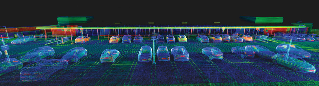
The data were collected in and around a car park to prove how Lidar Inertial Odometry (LIO) can be used to retain accuracy for longer periods without GNSS updates. (Photo: OxTS)
What is your company’s niche in surveying/mapping?
CHC Navigation
CHC Navigation (CHCNAV) has been at the forefront of positioning and navigation for more than two decades, continually adapting to meet the diverse needs of the surveying and mapping industry. Our innovative solutions often lead the industry in providing end-to-end, integrated technology fusion — GNSS, inertial measurement unit (IMU) and imaging lidar — as a standard that empowers geospatial professionals worldwide. CHCNAV strives to provide accessible, value-added solutions from the start, positioning itself as a key technology enabler for the geospatial community.
Hexagon
Whether you are mapping an entire city or surveying a site for construction, capturing reliable and precise geospatial data is essential. Hexagon’s niche lies in its commitment to innovation, its extensive portfolio and the convergence of superior hardware, intelligent software solutions and expert services — enabling precise, efficient and scalable surveying and mapping for diverse needs. Our multitude of solutions, whether handheld, tripod-mounted, flying, or vehicle-mounted, are designed to collect data efficiently and safely from complex or dangerous environments — enabling the greatest accuracy and high-value deliverables.
Furthermore, Hexagon is uniquely positioned with its robust suite of software solutions that work seamlessly with our hardware, such as Reality Cloud Studio, Leica Cyclone, Leica Captivate or Leica Infinity for collecting, processing, modeling, analyzing, and presenting data. We offer end-to-end solutions that not only provide high accuracy but also ensure productivity and ease of use.
OxTS
OxTS offers localization and georeferencing technology that can help accelerate the collection of high accuracy survey data, allowing more work to be completed in a given time frame without compromising on accuracy.
Trimble
Trimble is known for offering a wide range of highly accurate and reliable data capture sensors but our “niche” — our truly unique offering — is our ability to offer comprehensive solutions that make our customers more productive and their projects more streamlined. We do this through hardware and software solutions that enable highly efficient survey and mapping workflows that connect field and office operations. Our software helps transform the captured data into true information utilizing an increasing number of AI-powered tools while our cloud services allow customers to share the data with a variety of stakeholders, unlocking the transformational power of geospatial data.
What is your latest surveying/mapping product? What are its key specs, markets and applications?
Hexagon
Among our surveying and mapping solutions, the Leica BLK ARC stands out with its flexibility to integrate with various robotic and mobile carriers. The BLK ARC provides autonomous laser scanning with static and dynamic scans, creating 3D digital twins and ensuring operator safety. Similarly, the Leica BLK2GO introduces an agile, handheld mobile scanning solution, capturing point clouds and images, with a user-friendly design. Both solutions are great allies for professionals requiring accurate, efficient, and versatile mobile scanning solutions.
For those looking to offer wide-scale data-capturing capabilities and overcome capacity constraints, the Leica Pegasus TRK mobile mapping system stands out because it can gather extensive data quickly and accurately. Its high-resolution data capture, advanced lidar technology, and enriched 3D point cloud capabilities ensure detailed and comprehensive datasets. Building on this range of solutions, the autonomous flying laser scanner Leica BLK2FLY enhances surveying efficiency by capturing hard-to-reach areas and environments. Its user-friendly operations, advanced obstacle avoidance and seamless cloud-based data integration make it a valuable tool for enhanced productivity and safety in surveying work.
CHC Navigation
Our latest offering, the RS10, demonstrates the integration of surveying and mapping technologies by combining GNSS RTK, laser scanning and visual SLAM into a unified platform. The RS10 enhances traditional GNSS capabilities with V-lidar and SFix technologies. V-lidar enables non-contact offset measurements up to 15 m, ideal for rover applications. Meanwhile, SFix technology leverages laser and visual SLAM data to deliver 5 cm accuracy within one minute in environments with weak or absent GNSS signals. This breakthrough enables accurate GNSS measurements in challenging environments such as indoor spaces and urban canyons, bringing simplified workflows and increased productivity to professional surveying and mapping.
OxTS
OxTS recently released Lidar Inertial Odometry (LIO), which offers improved localization in GNSS-obstructed environments while maintaining a fully global frame output. It means that survey data can retain accuracy for longer in harsher GNSS environments but doesn’t give up the global reference to coordinate frames used by surveyors and does not require ground control points to be anchored to those coordinate frames.
Trimble
The newly released Trimble Business Center (TBC) v2024.00 delivers on its commitment to innovation by offering technological integration and workflow optimization, as well as adaptability and innovation for the ultimate field-to-finish workflow. A key highlight in the new release is the seamless integration of survey data delivery for pavement inspection within AgileAssets, which bridges the gap between Esri and Autodesk through feature services for more efficient pavement management.
In addition, AI technologies provide enhanced point cloud classification and new feature extraction routines for game-changing analysis of aerial, terrestrial, mobile mapping and tunneling data. Collaboration also is greatly enhanced through Trimble Connect for seamless data integration across TBC and Trimble Access field software.
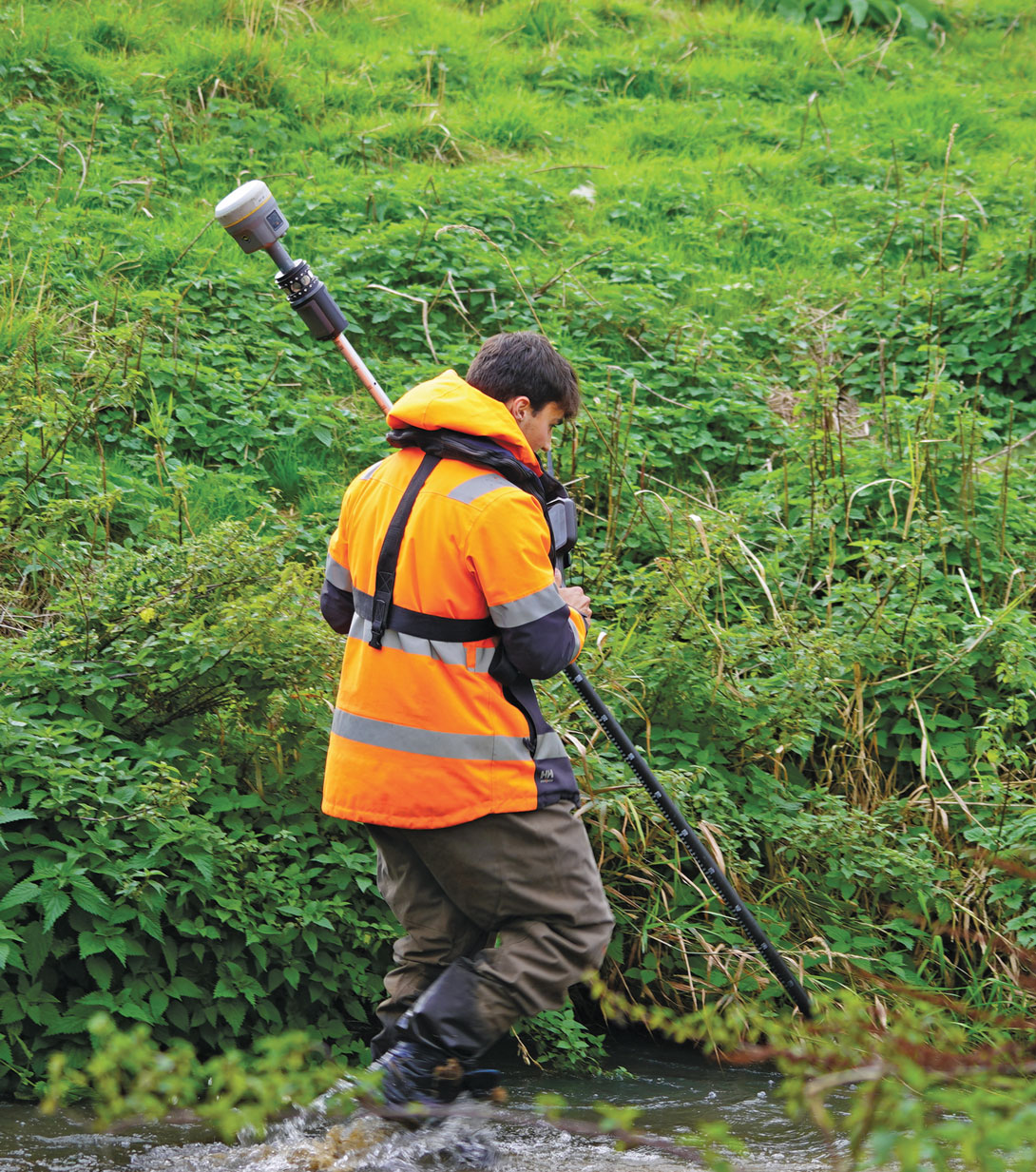
Josh Humphriss, surveyor at Storm Geomatics Limited, surveys a stream with a Trimble GNSS system in Shipston-on-Stour, Warwickshire, England in 2022. (Photo: Michael Dix, Marketing Communications Manager, Trimble, Inc.)
Jamming and spoofing continue to be the key challenges to military use of GNSS. While the production and adoption of M-Code receivers is delayed, defense contractors are developing several approaches to identify, locate and neutralize these threats — including CRPA antennas, embedded GPS inertial (EGI) navigators, software-defined radios and cryptography.
In this month’s cover story, executives from seven companies present their perspectives on the GNSS/PNT challenges faced by U.S. and allied military forces, their market niche in this area, and their latest products.
Lou Pelosi, vice president, CAST Navigation
Stig Pedersen, executive vice president of aerospace and defense, Autonomy & Positioning division, Hexagon
Brandon Malatest, COO, Per Vices Corporation
Tony Full, director of business development, Navigation Systems, Safran Federal Systems
Paul Crampton, senior solutions architect, Spirent Federal Systems
Joel Korsakissok, president, Syntony
Click here to read an exclusive interview with Chuck Stoffer, director of business development and Eric Hughes, design engineer, UHU Technologies
Read the related “Innovation” article.
Photo: Petty Officer 1st Class Thomas Gooley
What are currently the top two or three challenges regarding GNSS/PNT for U.S. and allied military forces? How do you expect that to change in the next three to five years?
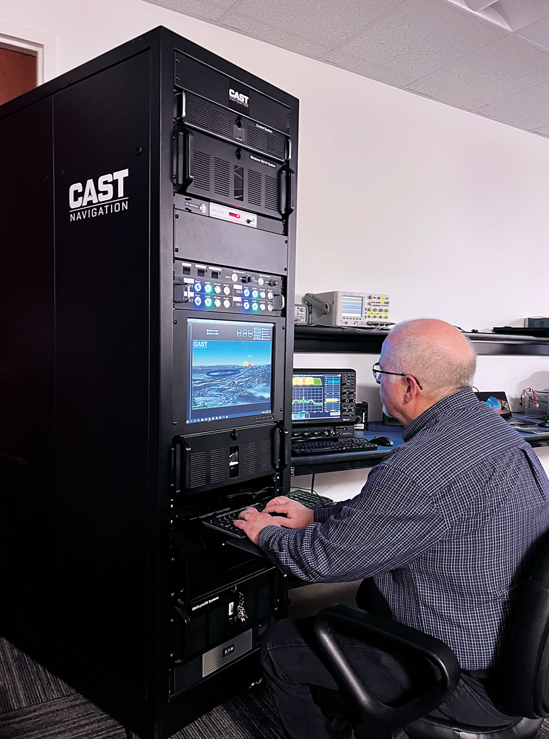
CAST Navigation
A top challenge is anti-jamming. GPS signals are low-power and fairly easy to jam. CAST has developed a simulator for testing controlled reception pattern antennas (CRPAs), which are anti-jam antennas. CAST simulators can test CRPAs with two to seven antenna elements.
Another top challenge is preventing our enemies from using GPS in a war zone. M-Code Modernized Navstar Security Algorithm (MNSA) has been designed to support denial of GPS signals to enemy forces. CAST has developed the ability to simulate M-Code MNSA. The company is working closely with the U.S. Space Force Space Systems Command’s GPS Directorate to develop a simulator that supports all their requirements.
Hexagon
Jamming is the key challenge. The secondary challenge is getting necessary protection into fielded systems so they can be used to the full extent of their service life. Over the next three to five years, while new products designed to safeguard PNT infrastructure will emerge, the process of getting these tools authorized and integrated will remain complex.
Per Vices Corporation
GNSS signals can be disrupted or manipulated by adversaries through jamming techniques, leading to potential navigational errors or loss of positioning capabilities. Advanced spoofing techniques also pose significant challenges to GNSS/PNT for U.S. and allied military forces, as they can deceive receivers into providing inaccurate positioning, navigation, and timing information. Both can be addressed with the integration of software-defined radios (SDR) for GNSS/PNT applications where we anticipate a strong push to further advance the different anti-jamming and anti-spoofing techniques in software using high-performance SDR platforms.
Safran Federal Systems
GNSS denial and spoofing. Both challenges are expected to become more pervasive over the coming years as adversarial technologies evolve and are distributed. In the current conflict, systems are driving to become either assured GNSS or built to operate independently of GNSS clock and position information.
Spirent Federal Systems
Adversarial near-peer threats to PNT integrity are developing at an increasingly rapid pace. Navigation warfare (NAVWAR) used to focus within the boundaries of localized geopolitical conflicts, but now space-based, system-wide threats loom large and will present new challenges in the coming years. As PNT continues to evolve, more complex mitigation technologies must be integrated into a layered PNT ecosystem with shortened development and testing phases to be fielded faster.
Syntony
It is not a secret that jamming and spoofing will be the biggest challenges in the coming years: Almost every week, if not every day, we read some news about jammed or spoofed GNSS receivers, either in Eastern Europe or elsewhere.
Technology exists to protect against both threats: authentication, cryptography and CRPA. However, you cannot deliver an M-Code or PRS receiver to every soldier and every vehicle, if for no other reason than the difficulty of broadcasting the keys. The solution will pass by an intermediate level of anti-jamming and anti-spoofing receivers, which do not need them, associated to moderate prices and lighter infrastructure so that everybody and every vehicle can be protected.
For industry, it will pass through the generalization of CRPA architecture for the receivers, even for non-encrypted signals, and even with lower efficiency levels (update rate, J/S, etc.) corresponding to low dynamic movement.
What is your company’s niche regarding military GNSS/PNT?
senior software engineer Neil O’Brien utilizing a CAST-8000 GNSS simulator to analyze CRPA trajectory data. (Photo: CAST Navigation)
CAST Navigation
We are known for correctly interfacing with the military’s embedded GPS inertial (EGI) navigators.
Hexagon
We have carved out a distinctive position in the military APNT sector. We provide receivers that give users access to the entire GNSS spectrum, fortified by our unique GNSS Resilience and Integrity Technology (GRIT). Hexagon also produces anti-jam antennas designed to safeguard GNSS receivers, offering our customers tested protection in hostile environments.
Per Vices Corporation
We design, develop, and build high performance software-defined radio platforms and associated firmware/software for use in GNSS/PNT systems. This includes the use of SDRs for simulating hostile RF environments to test existing equipment, providing anti-jamming and anti-spoofing solutions, implementing dynamic frequency hopping, and signal authentication and integrity verification.
Safran Federal Systems
We are uniquely positioned to fulfill solutions to GNSS denial and spoofing through our precision timing, assured GNSS (M-Code/SAASM) and inertial navigation technologies. Additionally, we have these technologies often combined in different form factors to serve platform needs. When planning for missions, we offer our customers a full suite of mission simulation capabilities expediting the fielding of technologies by assuring functionality in a lab environment.
Spirent Federal Systems
We find our niche in partnering with industry and military institutions to provide innovative test solutions. Spirent NAVWAR test solutions enable PNT receivers to mitigate the effects of current and prospective threats. This involves new secure encrypted signals, space-based assets in a variety of orbital configurations, antenna and processing techniques, non-U.S. PNT systems, and non-satellite sensors to name a few. Research into potentially useful PNT systems is also efficiently conducted using simulation techniques — without the need to develop and iterate expensive hardware. Working with industry and military partners allows Spirent Federal to engage at the earliest stages of research and development, allowing system integrators to benefit from the same test methodologies used by the developers.
Cerber CRPA receiver with four-channel antenna and Constellator CRPA simulator. (Photo: Syntony)
Syntony
We have developed two technologies aiming at addressing this problem: a high-end CRPA receiver based on non-encrypted GPS/Galileo signals bringing state-of-the-art anti-jamming capabilities and anti-spoofing ones even with open signals, and the same for high-end 4 CRPA simulators with up to 8 channels. We developed the latter with the U.S. company Keysight and will demonstrate it at ION Joint Navigation Conference (JNC) 2024.
What is your latest product in this area? What are its key specs? What is/are its main application/mission area/s?
CAST Navigation
We have merged the EGI test capability with a CRPA tester. This allows testing an EGI that is driven by a CRPA in a jamming environment. This simulator also will be available with M-Code MNSA in the future.
a hexagon gajt in action on a U.S. Army M1A2 Abrams tank. (Photo: Sgt. Andrew Greenwood)
Hexagon
GPS Anti-Jam Technology (GAJT) antennas from Hexagon’s Autonomy & Positioning division mitigate against jammers to ensure the continuous signals required for calculating position and time remain available. GAJT is a commercial off-the-shelf product, which ensures short-order lead times and quick deployment. GAJT antennas from Hexagon can protect against between two and six simultaneous jammers. In addition to protection, they provide situational awareness messages to indicate the presence of jammers.
Our upcoming product in this area is an anti-jam antenna characterized by its low size, weight, power and cost (SWaP-C). It will protect L1/L2 and pass through all other GNSS signals to ensure resilient positioning. This addition to the battle-tested GAJT product family means that powerful, proven anti-jam protection will be available for all platforms, including UAVs. GAJTs provide assured and resilient PNT data for NATO forces worldwide on land, at sea and in the air.
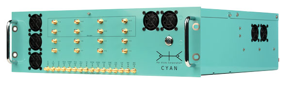
PER vices cyan software-defined radio for GNSS/PNT applications. (Photo: Per Vices)
Per Vices Corporation
Our latest product in this area is our Cyan SDR, which offers up to 16 radio chains, tuning frequency spanning all GNSS/PNT frequency bands (near DC to 18 GHz), a high performance FPGA SoC on-board (Intel/Altera Stratix 10), and multiple inputs and outputs for timing and synchronization with other equipment. This system has been utilized for many applications in this space due to its flexibility, performance, form factor (19″ 3U), and value.
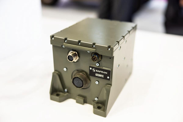
SAFran federal systems’ Geonyx inertial navigation solution, which can be integrated with VersaPNT, Safran’s all-in-one Assured PNT device. (Photo: Safran Federal Systems)
Safran Federal Systems
Safran’s Versa-PNT product coupled with a Geonyx inertial navigator offers rubidium oscillator precision timing, M-Code receiver and navigation-grade inertial technology, all in a package that can support land or maritime operations. More specifically, this package delivers:
P — M-Code receiver.
N — < 0.02% drift over the traveled distance (~2 m over 10 km, GPS accuracy).
T — One-day holdover below 1 µs.
Photo: Spirent Communications
Spirent Federal Systems
The PNT X is Spirent’s innovative sixth-generation simulation platform, which launched at the end of April and will debut at the ION JNC 2024 in June. PNT X offers a new era in NAVWAR testing, with a record 140 dB high dynamic range to simulate high-powered jammers and spoofers. It offers a 2,000+ Hz update rate for a highly accurate representation of the motion of missiles, rockets, and UAVs, thereby guaranteeing the integrity of test results.
The platform includes spatial awareness simulation for jammers and signals of opportunity, overlaying motion on user-defined signals and jammers alongside the simulation of the local environment and terrain.
The PNT X uses Spirent’s custom-built software-defined radios to extend capacity, automation and ease of use for testing current and future PNT sources. Designed for secure environments, the simulation solution features the first M-Code Regional Military Protection (RMP) test capability. Spirent experts are available to assist with generating test scenarios and capitalizing on new automation and interoperability features.
Syntony
The CRPA simulator that we will market together with Keysight will support all available GNSS signals and carrier frequencies. It also will be expandable by a software upgrade to LEO PNT in the near future. With typically four or eight channels,130dB of J/S, and based on the unique generator of Keysight VXG-C (2.5 Ghz instantaneous bandwidth, providing high-level phase synchronization all along the band), it will generate all the GNSS signals in L and S bands through one RF channel, bringing unrivaled performance and ease of calibration.
A roundup of recent products in the GNSS and inertial positioning industry from the April 2024 issue of GPS World magazine.
SURVEYING & MAPPING
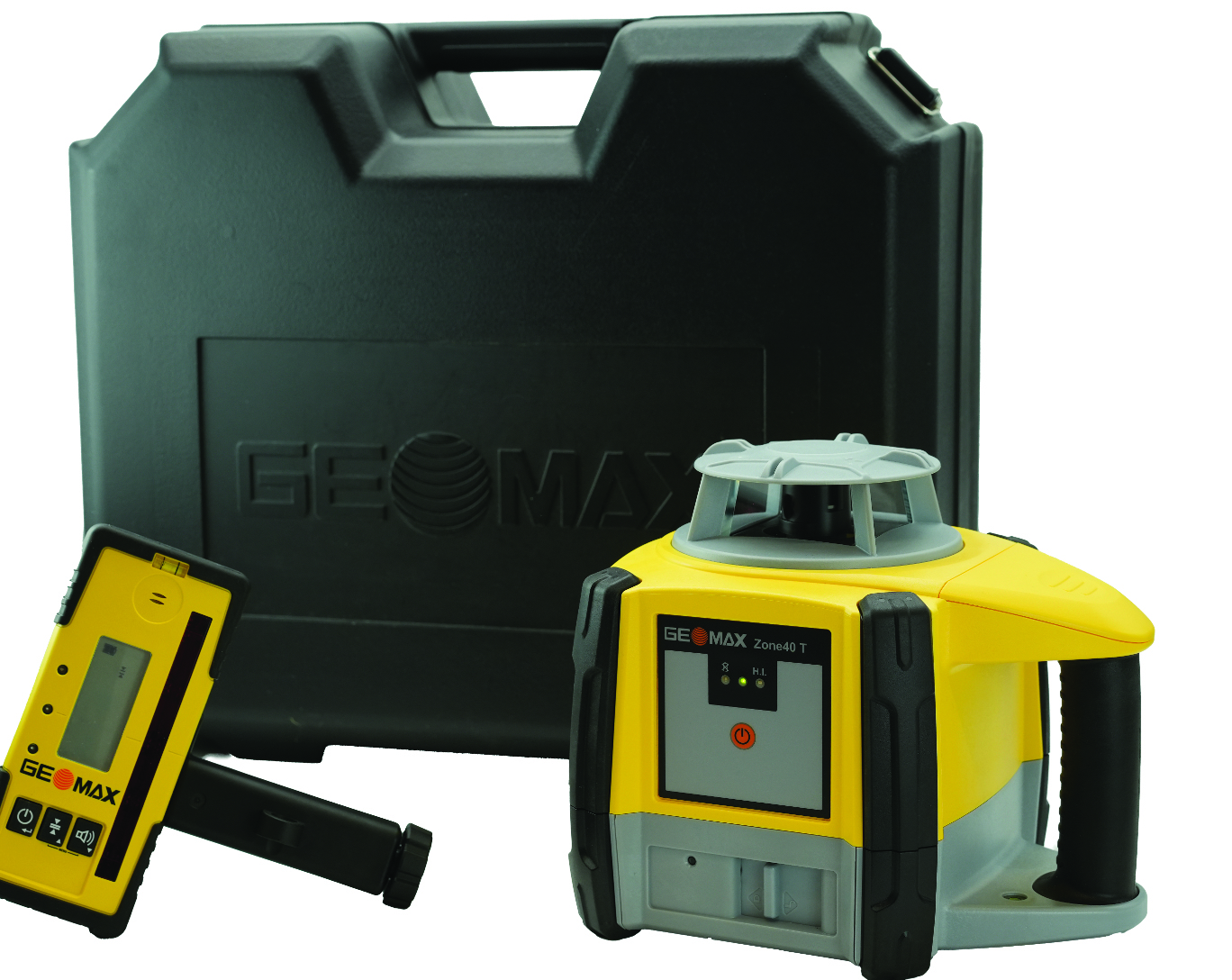
Rotating Laser Built for challenging worksites
The Zone40 T one-button rotating laser is designed for all types of grading and leveling jobs. It seeks to address the industry’s need for efficient and accurate alignment solutions.
Its one-touch operation is designed to simplify and increase efficient workflows in a variety of jobs such as grading, paving, excavating, surveying, layout and more. It is ideal for contractors, crew chiefs, supervisors and trade professionals.
GeoMax products are tested and proven to endure the toughest conditions. With an IP67 environmental rating, the Zone40 T accurately delivers in dust, water, wind and extreme temperatures. GeoMax Positioning, geomax-positioning.com
Hydrographic Surveying Solution With advanced inertial sensors
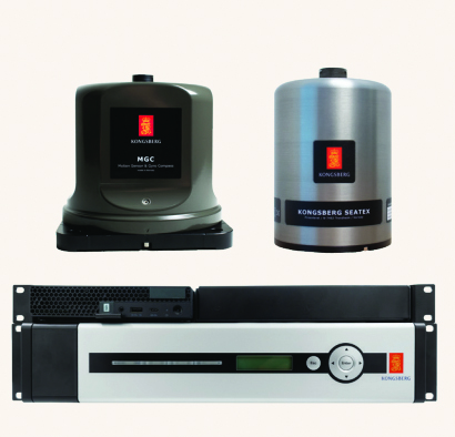
The Seapath 385 navigation system is designed to enhance precision in hydrographic surveying by using advanced navigation algorithms and integrating a range of satellite signals, including GPS, GLONASS, Galileo, BeiDou and QZSS, alongside geostationary satellite signals. The Seapath 385 system combines raw inertial sensor data from Kongsberg Discovery’s high-performance motion gyro compass (MGC) or motion reference unit (MRU) with GNSS data and corrections from real-time kinematics (RTK), precise-point positioning (PPP) or Differential Global Navigation Satellite System (DGNSS). The integration offers a robust and accurate navigation solution ideal for hydrographic surveying.
The system’s dead reckoning capabilities are attributed to its advanced inertial sensors and updated navigation algorithms. It uses GNSS antennas for both positioning and heading determination designed to add an extra layer of robustness to the system. The Seapath 385 also introduces a new post-processing format that consolidates all necessary data and system configurations into a single file, which allows for centimeter-level position accuracy through either satellite orbit and clock data or data logged from base stations.
Designed for ease of installation and continuous, reliable operation, the Seapath 385 is a modular system with a processing unit that handles all critical computations independently of the user interface on the HMI Unit. This feature offers precise measurements with a data rate of up to 200 Hz at multiple monitoring points, which makes it an ideal solution for accommodating sensors or systems that depend on motion or position data throughout the vessel. Kongsberg Discovery, Kongsberg.com
Marine-Grade Sensor Compatible with USVs
The Optech CL-360 Marine is a 360° long-range laser scanner. It combines a scan speed of 250 lines per second with 2 mm range resolution, a plug-and-play solution and an IP67 marine-grade sensor.The system can be seamlessly integrated with multibeam systems and the CARIS Ping-To-Chart workflow, which allows for full above-and-below-water image capture with survey-grade accuracy in a single workflow.It is ideal for mapping coastal infrastructure and is designed to be used on an uncrewed surface vessel (USV) that provides survey grade range and accuracy. Teledyne Geospatial, teledyneimaging.com
GNSS Receiver Designed for centimeter-level and RTK accuracy
The HiPer CR is a compact and lightweight GNSS receiver designed for centimeter-level and RTK accuracy for professionals in a wide range of applications in surveying, construction, engineering, forestry and mining. It joins a portfolio of fuller-featured receivers, including the HiPer HR and VR.
The HiPer CR tracks the GPS, GLONASS, Galileo, BeiDou and QZSS constellations. It can be used in a variety of configurations, including as a network RTK rover, in base and rover setups and in integrated hybrid use with a robotic total station.
When used as a network rover with Topnet Live — the company’s global GNSS correction service — the HiPer CR will have access to high-quality data corrections to increase efficiency and productivity. Users also can select to use the receiver as part of a hybrid positioning system, which allows users to use a robotic total station for prism measurements. Users also can switch to GNSS measurement with the HiPer CR for obstructed areas such as warehouses, trailers, or buildings.
Topcon Positioning Systems, topconpositioning.com
Handheld SLAM laser scanner For in the field and indoors
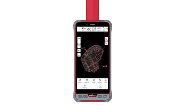
The RS10 is a handheld SLAM lidar laser scanner integrated with a full real-time kinematics (RTK) GNSS receiver.
Designed to improve efficiency across a wide range of mapping and surveying applications, the RS10 seeks to provide professionals with a versatile, all-in-one tool for capturing 3D geospatial data in both outdoor and indoor environments.
The RS10 integrates a GNSS smart antenna for RTK positioning accuracy even in challenging environments. It delivers 5 cm measurement accuracy by fusing high-precision lidar, RTK, laser and visual SLAM using three HD cameras.
The RS10 uses a powerful onboard processor for real-time georeferenced point cloud generation in the field. Users can receive instant feedback, which allows them to adjust while scanning. Large sites up to 13,000 square meters can be mapped in real time.
The integration of high-precision GNSS and SLAM technologies eliminates the need for traditional loop closure, which often complicates the data collection process for handheld scanners. Users can freely scan target areas without having to return to previous locations, which can streamline field data capture and significantly reduce time spent in the field. CHC Navigation, chcnav.com
Airborne lidar sensor With scan pattern reconfigurability
The Leica TerrainMapper-3 airborne lidar sensor features a new scan pattern reconfigurability to support a variety of applications and requirements in a single system.
The system offers three scan patterns, which allow users to customize the sensor’s performance to fit specific applications. Its circle scan patterns are designed to improve 3D modeling of urban areas or steep terrains. The ellipse scan patterns use data capture for more traditional mapping applications. Skew ellipse scan patterns are aimed at improving point density for infrastructures and corridor mapping applications.
The sensor has a high scan speed rate and a 60° adjustable field of view to maximize data collection with fewer flight lines. The TerrainMapper-3 is complemented by the Leica MFC150 4-band camera, which operates with the same 60° field of view coverage as the lidar for exact data consistency.
The device’s reduced beam divergence offers more accurate results, while its new multiple pulses in air (MPiA) handling is designed to deliver more consistent data acquisition, even in steep terrain.
The system introduces possibilities for real-time full waveform recording at a maximum pulse rate to open opportunities for advanced and automated point classification. Leica Geosystems, leica-geosystems.com
Mobile Mapping Solution Mounted on vehicles or trains
The Trimble MX90 mobile mapping system integrates advanced Trimble GNSS and inertial technology with Trimble field and office software. It offers users a comprehensive field-to-finish mobile mapping solution designed for robust workflows for data capture, processing and analysis.
The MX90, mounted on vehicles or trains, captures detailed laser scans and imagery —panoramic and multi-angle. This data, collected at highway speeds, undergoes rapid processing to produce deliverables for feature detection and inspections.
The mobile mapping system includes immersive 360° panoramic and targeted cameras to capture high-resolution imagery of various details, such as small or distant road and rail signs, telecommunications towers or cracks and holes in roads.
Additionally, it offers high-density colorized point clouds with rich and accurate color projections. These dense point clouds, along with high-resolution imagery — panoramic and planar — and accurate trajectories, provide the basis for a wide range of deliverables, including street scenes, road and rail asset details, elevation models, volume calculations, 3D city models and as-built surveys.
It features a high-end inertial measurement unit (IMU) combined with IN-Fusion+ data processing technology to achieve high-quality data in challenging GNSS environments. The MX90 also comes with reliable office software solutions to support multiple use cases and applications, such as road inspection workflows and integration into cloud-based applications for efficient data sharing. Trimble Geospatial, geospatial.trimble.com
Collaborative Mapping Tool With spatial analysis features
Felt 2.0 is a collaborative mapping tool with powerful data transformation tools. Now with spatial analysis features, users can manipulate and analyze geographic data. It has web-based collaboration features designed to make mapping workflows interactive and accessible across organizations.
The software uses artificial intelligence (AI) to deliver faster workflows for geographic information systems (GIS) professionals. Users can utilize Felt’s Upload Anything capabilities to visualize any file format. The system will read, understand and deliver an internet-fast visualization to the users’ workspace. The software is available for download on tablets and other mobile devices. Felt, felt.com
Automatic Identification System Available on Android, IOS, PC and Mac
The Over the Horizon (OHA) automatic identification system (AIS) is the newest update to the savvy navvy app. The update uses a phone’s internet connection to stream other vessels’ locations in real-time directly to the app to improve safety on the water.
Traditional AIS received from the transceiver on the boat has a range of a few miles, whereas OHA is designed to show vessels further afield. While OHA does require an internet connection, users do not need additional hardware to see information on vessel movements.
OHA AIS allows users to see vessels directly on the chart with small and large vessel crafts defined by different colors. Users can also check how crowded an anchorage might be — either from onboard or while planning routes at home.
The savvy navvy application highlights when no position has been received for more than 30 seconds, which marks the positional variance area around each vessel and allows users to be extra vigilant when navigating.
Available on Android, IOS, PC and Mac, the savvy navvy app can be used on multiple devices and is available in both free and “premium” options with enhanced access and functionalities. savvy navvy, savvy-navvy.com
UAV
Real-Time Command and Control System Supports BVLOS
VigilantHalo is a software-based platform designed for real-time command and control of uncrewed airspace. The system supports a wide range of missions from air traffic control (ATC) to beyond visual line-of-sight (BVLOS) operations and counter-uncrewed aerial systems (C-UAS).
VigilantHalo combines radar and multi-sensor surveillance technology into a comprehensive situational awareness solution. It is designed for disaster response and critical infrastructure defense and can be customized for specific mission requirements. The system’s flexibility allows deployment across cloud, mobile or fixed-site installations, which aims to address the evolving threats in national security and the National Airspace System (NAS).
The system features integrated data processing, a fusion tracker and a communications system that enables operators to monitor and manage air traffic under various conditions. It leverages weather analytics from the National Oceanic and Atmospheric Administration (NOAA) and other sources to assess flight paths and identify safety risks. VigilantHalo uses a custom sensor data processor (SDP) that integrates data from different sensors and surveillance feeds into a unified display tailored to specific missions such as ATC, BVLOS, air defense and more.
BlueHalo, bluehalo.com
Dynamic Channel Switching Improves communication in the field
The Skydio X10D UAV features dynamic channel switching to monitor signal interference and move to a clearer channel. This aims to improve wireless transmission signal quality during flights to ensure troops maintain communication with the UAV to accomplish their mission.
Dynamic channel switching allows the X10D to provide adaptable communications between the drone and its accompanying controller in situations where the airspace is congested or under electronic warfare conditions. This feature ensures that reliable command and control is maintained and real-time data feeds are available even in challenging conditions.
The X10D is designed for intelligence, surveillance and reconnaissance (ISR) applications critical to defense and government agencies. It delivers advanced sensor technology, autonomous navigation and a modular, open architecture for military needs.
Skydio’s onboard AI and autonomy for small unmanned aircraft systems (sUAS) offers obstacle avoidance in zero-light environments and autonomous flight. Skydio X10D delivers enhanced compliance with federal standards, including the Robotics and Autonomous Systems – Air (RAS-A) Interoperability Profile (IoP) and an open, modular platform that supports third-party applications. RAS-A compliance and open MAVLINK protocol enable the use of third-party and government-owned flight application software. Skydio, skydio.com
Lidar Sensor Integrates with UAVs
The JoLiDAR-1000 is a new lidar sensor for UAVs. It aims to improve applications in GIS, surveying, and precision inspections of power lines. The JoLiDAR-1000 incorporates advanced lidar technology to improve measurement accuracy for UAV applications.
The sensor features a 1,000 m medium-range laser scanner, using RTK and inertial measurement unit (IMU) fusion technology and laser scanning for enhanced measurement precision. It achieves a measurement accuracy of 5 mm, a repetition accuracy of 10 mm and a line scanning speed ranging from 10 lines to 300 lines per second. It has a 100° field of view and an angular resolution of 0.001 to precisely detect objects at extended distances.
Designed with compact dimensions and weighing only 1.9 kg, the JoLiDAR-1000 is portable and integrates seamlessly with various UAV platforms. It incorporates a suite of technologies, including a GNSS high-precision positioning system, IMU, high-speed data acquisition systems, time synchronization systems and a 26MP RGB camera to enhance its data collection capabilities.
The JoLiDAR-1000 streamlines operational processes by eliminating the need for base station setup and ground control points. It is equipped with high-precision POS solution computation and point cloud fusion capabilities. The sensor is suitable for a wide range of applications such as terrain mapping, power line inspection, mining surveying, coastline measurement, emergency mapping and natural resource surveying.
JOUAV, jouav.com
AI Autopilot Designed for USVs
The Voyager AI Autopilot converts newly built or retrofitted unmanned surface vessels (USVs) into fully autonomous craft.
The Robosys Autopilot module seamlessly integrates with Robosys’ Voyager AI Survey as part of the Voyager AI software suite. It enables remote and autonomous heading and speed control as well as various other mission modes for navigation and vessel control, specifically for hydrographic and oceanic surveying operations.
The marine autopilot is designed to meet the demands of 3 m to 12 m electric drive surveys. It is easily scalable to full advanced autonomous navigation, which seamlessly integrates with third-party steering, drive and motor control systems to provide optimal vessel functionality for USVs and other craft.
Robosys Automation, robosysautomation.com
OEM
Satellite Positioning Chips With AEC-Q100 Grade 2 reliability qualification
Designed for automotive applications, the AG3335MA satellite positioning chip series has earned AEC-Q100 Grade 2 reliability qualification. The AEC-Q100 is designed to ensure reliability and safety beyond the requirements for consumer electronics.
The AG3335MA series chips have been certified by a third-party quality management system equipped with an automotive specification laboratory. Achieving Grade 2 certification, these chips are tested for operation in extreme temperatures ranging from -40°C to 105°C, which caters to the demanding environments of automotive applications.
The AG3335MA features ultra-low power consumption, high endurance and dual-frequency capability. It supports the five major global satellite systems and NavIC to ensure reliable operation in a broad temperature range and challenging weather conditions. Its GNSS receiver measurement engine has a satellite tracking sensitivity of -167 dBm and a cold boot positioning time of 25 seconds. This allows it to receive and process signals from all visible satellites simultaneously, offering increased accuracy in positioning.
Airoha Technology, airoha.com
SOM-SMARC Modules Powered by Qualcomm
The Smart Mobility Architecture (SMARC) System on Modules (SoMs) are based on Qualcomm QCS6490 and Qualcomm QCS5430 application processors. These new SMARC modules are the first results of SECO’s strategic collaboration with Qualcomm Technologies, announced in September 2023.
The SOM-SMARC-QCS6490 is designed to simplify the use of the Qualcomm QCS6490 processor. The chipset offers support for artificial intelligence (AI) and computing, robust performance at low power and expanded interfaces and peripherals catering to diverse industrial use cases.
The Qualcomm Adreno 643 GPU offers enhanced graphics performance and energy efficiency. It supports FHD+ at 120 fps resolution on primary and secondary displays up to 4k Ultra HD at 60 Hz. The SOM-SMARC-QCS6490 supports Microsoft Windows 11 IoT Enterprise, Yocto Linux and Android, with both commercial (0°C to +60°C) and industrial (-30°C to +85°C) temperature variants available.
The SOM-SMARC-QCS5430, powered by the Qualcomm QCS5430, is a mid-tier solution that slightly moderates CPU and GPU performance. This system-on-chip (SoC) combines enhanced connectivity, performance and edge AI-powered camera capabilities. It also provides scope for field software-based upgrades of the CPU and GPU by using the processor’s capabilities.
SECO, seco.com
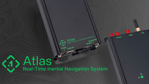
INS Featuring FOG-based IMU
The Phins 9 Compact is a high-performance inertial navigation system (INS) designed for all unmanned underwater vehicles. It offers a blend of navigation performance, reliability and size, weight and power (SWAP) efficiency.
The Phins 9 Compact is built around a high-performance fiber-optic gyroscope (FOG)-based IMU with advanced accelerometers. With compact dimensions, a DVL-aided position accuracy of 0.1% TD, and a power consumption of less than 7 W, it is ideal for compact subsea vehicles in demanding applications with low power requirements.
The INS aims to redefine the standards of subsea navigation in a wide range of applications, including survey-grade coastal and offshore seabed mapping, inspection repair and maintenance (IRM), defense and more. Exail, exail.com
MOBILE
GNSS FR Antennas Supports a full spectrum of bands
This series of GNSS RF antennas is designed to elevate location-based services with enhanced accuracy and precision. This new lineup aims to outperform conventional GPS technologies by offering faster signal acquisition, improved tracking capabilities and reduced power consumption.
The antennas support a full spectrum of bands, including L1, L2, L5, and L-band data correction services. It can be used in a variety of sectors, such as agriculture, surveying, the Internet of Things (IoT), mapping, defense and aviation.
The technology is designed to meet the rigorous demands for precise location data across various applications. These antennas offer multi-band and multi-constellation support to ensure broad compatibility. With centimeter-level accuracy, these antennas are crucial for aerospace, defense, asset tracking, geolocation, precision agriculture and industrial IoT. Abracon, abracon.com
Iridium on the Go Magnetic mount antenna
The 2J7426MPz by 2J antenna is a high-performance magnetic mount antenna that is designed specifically to communicate efficiently with the Iridium satellite communication system. It is manufactured with high-quality polycarbonate (PC) and acrylic-styrene-acrylate terpolymer (ASA), a thermoplastic combination that offers strong resistance to UV, moisture, and heat and enhances mechanical properties.
The antenna housing is waterproof to IP69 standards and designed to operate in extremely harsh environments, including those with frequent exposure to water, dust and debris. It has a recommended operational and storage temperature of -40°C to +85°C. The magnetic mount allows for easy installation and removal between vehicles or assets, and it is easily converted to an adhesive type for greater flexibility.
It is delivered with a standard SMA-male connector and a standard 300 cm long coaxial LL100 cable. Iridium has certified the 2J7426MPz antenna for commercial use in connection with the Iridium communications system. SparkFun Electronics,sparkfun.com
CHCNAV’s Apache USV, made of macromolecule polyester carbon fiber and Kevlar fiber-glass, can be carried by a single person. (Image: CHCNAV)
Bridges are essential components of our transportation infrastructure, facilitating seamless travel and connecting communities. The construction and maintenance of a bridge is an ongoing process, influenced by a variety of natural factors, including topography, geology, meteorology and hydrology. To protect the foundations and ensure the structural integrity of bridges, it is critical to continuously monitor bridge piers with a focus on providing consistent data support. For this project, the acquisition of 3D point cloud data of the riverbed surrounding a bridge is essential for the long-term safety monitoring of its abutments.
The Challenge of Traditional Surveying Method
Traditionally, bridge pier surveys are conducted using manned boats equipped with multibeam sonar — a method that, while mature, faces several challenges:
1. Significant safety hazards. Survey areas are prone to tidal changes, high winds, waves, and traffic from passing vessels, which can often create dangerous working conditions. Stone ridges along the riverbanks, potentially hidden during high tide, pose additional risks to manned boats surveying near bridge piers.
2. Low operational efficiency. After a typhoon, the timeline for surveying is tight. However, setting up and calibrating multibeam sonar equipment on manned boats is time-consuming. Operations in shallow areas, such as riverbanks and near central river sandbars, are limited to short periods of low tide, requiring strict adherence to schedules.
3. Poor data quality. Multibeam surveying requires overlaps of more than 20%. Accurate route keeping by manned boats, critical to multibeam surveying, is often compromised by environmental conditions and operator experience, resulting in poor data quality. In addition, GNSS signal reception under bridges is poor, affecting positioning accuracy and thus the integrity and efficiency of data collection.
4. High operational costs. The lack of specialized underwater topographic survey vessels requires the rental of traditional manned boats, which increases project costs.
A USV can operate where it would be dangerous or inefficient for a manned boat. (Image: CHCNAV)
The CHCNAV Solution: Efficient Autonomous Surveying
To overcome these obstacles, one bridge project team implemented an innovative solution: the use of the Apache 6 unmanned surface vessel (USV) coupled with a NORBIT multibeam echosounder and an iLiDAR 3D laser scanner. This integration results in a system that is not only lightweight, compact, and easy to install and operate, but also portable and energy efficient.
The Apache 6 USV, with its all-carbon fiber hull weighing only 15 kg, combines lightness with durability. Its modular design simplifies logistics and transportation, while its ability to withstand offshore conditions and automatically follow pre-determined routes enhances operational efficiency. The system synchronizes surface and underwater data, with beams capable of scanning shallow flats and channel slopes. The echosounder and iLiDAR share position, heading and attitude data to optimize cost efficiency.
The iLiDAR 3D laser scanner features an ultra-lightweight design, with the main unit weighing less than 3 kg. Its high level of integration, requiring only a single cable for full-surface data access, and compatibility with leading multi-beam data acquisition and processing software underscore its utility.
Advantages of Using USVs
Compared to traditional manned boat surveys, the Apache 6 USV’s integration of surface and underwater sensors offers several advantages, including high integration, compact size, safe unmanned operation and lower operating costs. In addition to ensuring the safety of personnel and bridge structures, it increases survey efficiency in complex environments. Using this autonomous survey system, two project engineers were able to create a high-resolution 3D point cloud model of the riverbed scour around the bridge piers at a low operational cost. This dataset is invaluable for ongoing safety monitoring of the bridge piers, facilitating proactive maintenance and ensuring the long-term stability and reliability of this critical transportation infrastructure.
Several technologies — ranging from very mature to nascent — are converging to make autonomous vehicles and devices more useful, efficient, and reliable than ever. They include real-time kinematic (RTK) GNSS, inertial navigation systems (INS), cameras, and radar for navigation; cameras, lidar scanners, multibeam echosounders, and a variety of other sensors for data collection; software-defined radios (SDRs) for secure communications; and artificial intelligence (AI) to plan routes, coordinate the movements of multiple autonomous vehicles and devices (including “swarms” of UAVs), and analyze the data collected.
Read this cover story, featuring case studies from Unicore and CHCNAV, interviews with executives at Per Vices and M3 Systems, and images from Frontier Precision and YellowScan.
CHC Navigation (CHCNAV) has released the RS10 handheld SLAM lidar laser scanner integrated with a full real-time kinematics (RTK) GNSS receiver. Designed to improve efficiency across a wide range of mapping and surveying applications, the RS10 seeks to provide professionals with a versatile, all-in-one tool for capturing 3D geospatial data in both outdoor and indoor environments.
The device integrates a GNSS smart antenna for RTK positioning accuracy even in challenging environments. It delivers 5 cm measurement accuracy by fusing high-precision lidar, RTK, laser and visual SLAM using three HD cameras. It uses a powerful onboard processor for real-time georeferenced point cloud generation in the field. Users can receive instant feedback, which allows them to adjust while scanning. Large sites up to 13,000 square meters can be mapped in real time.
The integration of high-precision GNSS and SLAM technologies eliminates the need for traditional loop closure, which often complicates the data collection process for handheld scanners. Users can freely scan target areas without having to return to previous locations, which can streamline field data capture and significantly reduce time spent in the field.
For centuries before sonar, lidar and unmanned surface vehicles (USVs), sailors would measure depths by throwing a line overboard with a lead weight at the end — called a leadline — and record its length to the seafloor. Mapping large areas of the seafloor, therefore, required thousands of these measurements.
However, even after extensive measurement efforts, the acquired data was often inaccurate or incomplete, which forced navigators and surveyors to estimate the seafloor’s bathymetry until remote sensing was introduced in the 1970s.
Since then, the growing need for increasingly accurate and rapidly available data has led to a worldwide effort to develop sensors and alternative techniques for measuring depths.
In the ongoing Florida Seafloor Mapping Initiative (FSMI), the Florida Department of Environmental Protection tasked Woolpert Geospatial Program with acquiring bathymetric survey data using lidar technologies to produce a comprehensive, publicly available, high-resolution seafloor surface model of Florida’s coastal waters by 2026.
Similar initiatives across the globe have kick-started innovations in underwater data collection and interpretation. In this feature, SBG Systems, CHC Navigation (CHCNAV) and Advanced Navigation describe how they used modern hydrographic surveying to aid defense departments, produce 3D topographic maps, and analyze the depth of The Great Blue Hole in Belize.
Exploring challenging waters
SBG Systems
Advancements in hydrographic surveys can lead to the exploration of depths previously unknown. The Great Blue Hole, located off the coast of Belize, is the largest marine sinkhole in the world, with a diameter of 300 m and a depth of 125 m. This major scuba hotspot is part of the Belize Barrier Reef Reserve System and a UNESCO World Heritage Site.
Aquatica Submarines conducted an expedition survey of the Blue Hole. For two weeks, a team of scientists, explorers, and filmmakers collected survey data and captured photos and videos of this geological wonder. It is the first time in history that an expedition of this scale was attempted at the Blue Hole.
The challenge: Finding submersibles to equip with sonar
The expedition team chose two submarines to carry out the survey: its Stingray 500 and the Roatan Institute of Deepsea Exploration’s IDABEL. Both vessels can carry up to three persons for a maximum of 12 hours.
Norwegian technology group Kongsberg’s dual-axis sonar technology was used to create a 3D representation of the sinkhole. The surface and submarine-mounted sonar equipment were also equipped with SBG Systems’ Ellipse miniature inertial navigation system (INS).
The Ellipse was used to mark the Blue Hole perimeter and scientists then processed the recorded data using MS1000 processing software.
Additional steps and results: Analyzing 3D sonar maps
A key outcome of the expedition is the creation of a complete 3D sonar map of the Blue Hole using point-cloud data collected by Kongsberg’s dual-axis sonar to create a 3D map of the site. The sonar was pole-mounted on the survey vessel with the GPS receiver and motion reference unit directly over the scanner’s head.
Sonar expert Mark Atherton from Kongsberg’s Canadian subsidiary, Kongsberg Mesotech, was a key member of the science-based sonar and data collection team. Atherton operated the sonars aboard the Research Vessel Brooks McCall, contributing to an invaluable high-resolution map of the entire sinkhole.
“By understanding the geological history and geometric structure at the Blue Hole, we can contribute new data to the global scientific community studying sinkholes and cenotes,” Atherton said.
The team was able to conduct more than 20 dives into the large sinkhole, taking videos and 3D images during each trip. They also completed a two-hour live broadcast featured on The Discovery Channel.
“What [the Great Blue Hole] tells us is that sea level rise is not [always] a gradual process,” said Erika Bergman, Aquatica’s chief pilot and oceanographer. “We carefully measured the terraces and layers built up in the hole and we can see that sea level rise can happen dramatically.”
Producing 3D hydrodynamic models
CHC Navigation
Flood control structures — such as dikes, dams, spurs, drainage channels, and floodways — are designed to protect coastal and riverine areas of cities and farms and, above all, the people who live there.
To prevent flooding in low-lying regions and support national ecological protection and development strategies in the Yellow River Basin in China, the Ministry of Water Resources launched the “Digital Twin Yellow River Construction Plan (2022-2025)” project. The Chinese Bureau of Hydrology and Water Resources was tasked with building a digital twin flood model based on part of the country’s Yellow River, targeting the 28-km section of the river basin.
The challenge: Building and designing a digital twin flood model
The first step was to acquire 3D data underwater, on land, and from the air. CHC Navigation (CHCNAV) provided its Apache 6 and Apache 4 USVs to collect underwater data using multi-beam and single-beam echo sounders. The AlphaUni lidar system mounted on the BB4 UAV was used to gather the land data. Finally, the team obtained aerial data using an oblique photographic system from CHCNAV mounted on a UAV.
As a result, researchers obtained large-scale remote sensing images, laser point clouds, terrain data, oblique photography, CAD drawings, and BIM models.
The simulation and analysis of the historical flood events on the third party software; based on the data collected by CHCNAV’s USV and UAV. (Image: CHCNAV)
CoPre software, a 3D laser scanning pre-processing software that can process captured raw data, including POS trajectories, lidar data, and RGB images, was used for the Tilt and DOM modeling.
CoProcess software, designed for reality capture post-processing tasks and DEM/DTM generation, generated high-precision DEM models, a 3D representation of a ground surface created from elevation data, with a point cloud density of more than 50 points/m2 for the areas above and below the water.
Additional steps
The remotely operated vehicles and generated models obtained site data such as climate records, flood maps, flow records, hydrologic summaries, groundwater level records, water quality, and resource data to use as the basis of the analysis.
The team also used historical flood information during the scoping phase to develop a conceptual model of the flood mechanisms. Based on the actual flood records, a third-party flood simulation platform was used to produce the entire flood process for the different years.
The real-time flood extrapolation was processed on the third-party software, which simulated steady and unsteady flow patterns using hydrodynamic modeling algorithms.
“Advancements in bathymetric surveying, incorporating cutting-edge technologies such as UAVs with lidar, USVs with echo sounders, and high-precision positioning systems, have transformed the creation of digital twin models for water bodies, particularly the Yellow River in China,” said Taxiya Wang, Business Development Manager of Marine Survey at CHC Navigation. “This bathymetric surveying effort has laid the foundation for hydraulic models, flood maps, and customized applications, emphasizing the importance of up-to-date, high-quality data in watershed engineering and construction projects.”
The result
Based on the developed digital flood model, the next step for the digital watershed twin project is to collaborate with technical staff, experts, and users to create customized applications for watershed engineering and construction. The project is ongoing and will end in 2025.
Surveying wet gaps
Advanced Navigation
Defense departments are continuously looking to improve the safety of military personnel and equipment in conflict regions. With this aim, the UK Defense Science and Technology Laboratory (DSTL) launched its “Map the Gap” competition. It invited engineering firms to design and build an unmanned surface vessel (USV) capable of quickly, reliably, and safely surveying wet gaps — including rivers, streams, canals, and waterways — without putting engineers and other personnel at risk. Commanders can then view the survey data to determine the safest crossing points for troops and equipment.
DSTL relied on Advanced Navigation’s Spatial FOG Dual fiber optic gyroscope to conduct the hydrographic surveying project.
The challenge: Building a USV to assist defense forces
Challenges in the project included measuring water depths and flow rates, crossing lengths, river-bed topography, and riverbank heights, as well as shape profiling and assessing ground load handling capabilities. The vehicles also had to be either remotely operated or fully autonomous and deliver the collected data in a way that could be easily interpreted for quick decision-making.
The survey required multiple sensor technologies for simultaneous above- and below-water 3D surveys. For above-water use, dual lidar sensors produce high-resolution point clouds of the surrounding environment. For below-water mapping, a sensor suite consisting of a multibeam sonar, an Acoustic Doppler Current Profiler/Doppler Velocity Log (ADCP/DVL), and a cone penetrometer were used to measure current and water flow as well as to test substrate density.
Ultrabeam Hydrographic won the DSTL competition. Its team integrated multiple sensors into a single housing and selected the four-wheeled Axolotl vehicle for the second phase of the project.
Additional steps
An example of the highly detailed single-3D survey output from the Axolotl, showing features both above and below the water. (Image: Advanced Navigation)
The team was in search of a GNSS/INS device capable of dead-reckoning and maintaining accurate heading for extended periods of time, which led them to Advanced Navigation’s Spatial FOG Dual GNSS/INS.
Ultrabeam Hydrographic had previously been using a MEMS-based solution that could maintain a suitably accurate heading without GNSS for up to approximately 60 seconds. However, tests with the Spatial FOG Dual showed that it could maintain an accurate heading for more than 15 minutes.
“The MEMS can hold onto heading for maybe 30 seconds to a minute, accurately. After that, it’s not reliable,” Gabriel Walton, Ultrabeam Hydrographic’s technical director said. “We have used the Spatial FOG Dual in certain circumstances where we went 10 to 15 minutes without GNSS. I do believe it will go on for longer.”
The team integrated the Advanced Navigation solution into their survey management and mission control software. This allowed the Spatial FOG Dual to be used for survey purposes and to provide motion data to the robot’s artificial intelligence (AI) for autonomous mission control and object detection and avoidance.
The result
“Map the Gap” Phase 2 demonstrated that the Axolotl’s mechanical design, sensor suite integration, extensive use of AI for autonomous mission control, decision-making and precise navigation can serve as a significant advancement for bathymetric surveying.
Since “Map the Gap,” Ultrabeam Hydrographic has deployed the Axolotl on commercial waterway survey missions, such as surveying bridge sites and attaining a clear understanding of riverbed and water conditions.
A roundup of recent products in the GNSS and inertial positioning industry from the January 2024 issue of GPS World magazine.
SURVEYING & MAPPING
Laser Scanning Measurement System Compatible with specialized kits
The LS300 3D laser scanning measurement system utilizes simultaneous localization and mapping (SLAM) technology and advanced real-time mapping techniques. The LS300 3D operates autonomously, independent of GNSS positioning, making it ideal for harsh conditions in both indoor and outdoor environments.
LS300 includes a 120-meter working range and a sampling rate of 0.32 million points per second. Its point cloud accuracy is designed to perform in low reflectivity extended-range mode. The system is compatible with specialized kits, including the handheld form, back kit, car mount, and UAV kit.
By using data processing software specifically designed and developed for the LS series, users can handle large volumes of point cloud data and simplify complex tasks, including point cloud denoising, point cloud splicing, shadow rendering, coordinate transformation, automatic horizontal plane fitting, automatic point cloud data report generation, forward photography, and point cloud encapsulation.
During data post-processing, users can input absolute coordinates of control points, allowing these control points to adjust the data and improve scanning data accuracy. The LS300 incorporates a redundant battery design with two hot-swappable batteries, designed to prolong operation without frequent charging or interruptions. ComNav Technology, comnavtech.com
Anti-jamming receiver A jamming protector for legacy receivers
The KV-AJ3 tri-band anti-jamming receiver combines a digital antenna control unit (DACU) and a GNSS receiver. KV-AJ3 can be used as a jamming protector for legacy receivers or as a stand-alone GNSS receiver solution.
The tri-band solution decreases interferences from up to three directions in three frequency bands, including S-band. This approach is designed to provide significantly higher protection against interference compared to single-frequency devices.
The receiver has a digital port for navigation data output. Jamming-free RF signals can also be delivered to external non-protected GNSS receivers to obtain position, velocity, and time.
KV-AJ3 contains a MEMS inertial sensor, which allows for GNSS-aided INS solutions where coordinates and attitude angles are required. Kosminis Vytis, kosminis-vytis.lt
Lidar sensor Designed for high-speed airborne missions
The VUX-180-24 offers a field of view of 75º and a pulse repetition rate of up to 2.4 MHz. These features – in combination with an increased scan speed of up to 800 lines per second – which makes the VUX-180-24 suitable for high-speed surveying missions and applications where an optimal line and point distribution is required.
Typical applications include mapping and monitoring of critical infrastructure such as power lines, railway tracks, pipelines, and runways. The VUX-180-24 provides mechanical and electrical interfaces for IMU/GNSS integration and up to five external cameras.
This sensor can be coupled with RIEGL’s VUX-120, VU-160, and VUX-240 series UAVs. The system is available as a stand-alone sensor or in various fully integrated laser scanning system configurations with IMU/GNSS systems and optional cameras. RIEGL, riegl.com
UAV detection technology A 3D data fusion engine for complex environments
SensorFusionAI (SFAI) is a sensor-agnostic, 3D data fusion engine for complex environments. It accommodates all common UAV detection modalities, including radiofrequency, radar, acoustics, and cameras.
SFAI allows third-party C2 manufacturers to integrate SFAI into its C2 systems. This integration can be achieved through a subscription-based software-as-a-service (SaaS) model, enhancing system performance.
Key features of SFAI include behavior analysis to track an object to determine classification and predict trajectory; threat assessment that determines threat level based on a range of data types; and an edge processing device called SmartHub for reduced network load and high scalability. DroneShield, droneshield.com
Thermal mapping solution Designed for UAVs
The PT61 camera is a thermal mapping solution for UAVs. The camera system provides detailed thermal orthomosaic maps and accurate 3D models. Developed in partnership with Agrowing, the PT61 is a versatile tool designed for multispectral data collection in renewable energy and other domains.
The PT61 combines a 61-megapixel camera with integrated thermal imaging capability. It can also switch between RGB and multispectral modes, which aims to increase its versatility and address the increasing need for comprehensive data acquisition in various industrial and environmental applications.
Integrated with Agrowing’s multispectral lenses, the camera offers detail across 10 spectral bands and an infrared band, making it ideal for solar plant inspection and dam management.
The enhanced Topodrone post-processing software complements the hardware by streamlining remote sensing tasks, ensuring surveyors and researchers can achieve high levels of efficiency. Topodrone, topodrone.com
OEM
Dual-band GNSS receiver Achieves 50cm position accuracy without correction data
eRideOPUS 9 is a dual-band GNSS receiver chip that achieves 50cm position accuracy without correction data. eRideOPUS 9 is designed to provide absolute position information and can be used as a reference for lane identification, which is essential for services such as autonomous driving. It also serves as a reference for determining the final self-position through cameras, lidar, and HD maps.
The eRideOPUS 9 supports all navigation satellite systems currently in operation, including GPS, GLONASS, Galileo, BeiDou, QZSS, and NavIC. It can also receive L1 and L5 signals. The L5 band signals are transmitted at a chipping rate 10 times higher than L1 signals, which improves positioning accuracy in environments where radio waves are reflected or diffracted by structures, such as in urban areas — a phenomenon known as multipath.
A dual-band GNSS module incorporating eRideOPUS 9 is being jointly developed with Alps Alpine Co. and is scheduled for future release as the UMSZ6 series. Furuno Electric Co., Furunousa.com
Lidar scanning module Designed for OEM integration
The VQ-680 compact airborne lidar scanner OEM is designed to be integrated with large-format cameras or other sensors in complex hybrid system solutions.
It can be mounted inside a camera system connected to the IMU/GNSS system and various camera modules through a sturdy mechanical interface. The VQ-680 has laser pulse repetition rates of up to 2.4 MHz and 2 million measurements per second.
The VQ-680 is ideal for large-scale applications in urban mapping, forestry, and power line surveying. With a field view of 60º and RIEGL’s nadir/forward/backward (NFB) scanning, the system offers five scan directions up to ± 20º.
RIEGL, riegl.com
INS A product for avionic applications
The ADC inertial navigation system (INS) is designed to calculate and provide air data parameters, including altitude, air speed, air density, outside air temperature, and windspeed for avionic applications.
ADC’s compact form simplifies integration into existing UAV systems with strict size and weight requirements. The INS calculates the air data parameters using information received from the integrated pitot and static pressure sensors, along with an outside air temperature probe.
This compact device consumes less than one watt of power. It is designed for demanding environments, has an IP67 rating, and integrates total and static pressure sensors to calculate indicated airspeed accurately. ADC supports aiding data from external GNSS receivers and ambient air data, enhancing its precision in a variety of flight conditions. Inertial Labs, inertiallabs.com
Two tactical-grade IMU With L5 capabilities
The VN-210-S GNSS/INS combines a tactical-grade inertial measurement unit (IMU) comprised of a 3-axis gyroscope, accelerometer, and magnetometer with a triple-frequency GNSS receiver. The integrated 448-channel GNSS receiver from Septentrio adds several capabilities, including L5 frequencies, moving baseline real-time kinematics with centimeter-level accuracy, support for Galileo OSNMA, and robust interference mitigation.
These capabilities and high-quality hardware offer improved positioning performance in radio frequency-congested and GNSS-denied environments.
The VN-310-S dual GNSS/INS leverages VectorNav’s tactical-grade IMU and integrates two 448-channel GNSS receivers to enable GNSS-compassing for accurate heading estimations in stationary and low-dynamic operations. The VN-310-S also gains support for OSNMA and robust interference mitigation, offering reliable position data across a variety of applications and environments.
The VN-210-S and VN-310-S are packaged in a precision-milled, anodized aluminum enclosure designed to MIL standards and are IP68-rated. For ultra-low SWaP applications, VectorNav has introduced L5 capabilities to the VN-210E (embedded) when using an externally integrated L5-band GNSS receiver. VectorNav, vectornav.com
Real-time INS Used in large fleets
The Atlas inertial navigation system (INS) is designed for autonomous vehicles, mapping, and other applications. Atlas provides users with ground-truth level accuracy in real-time, which can streamline engineering workflows, significantly reduce project costs, and improve operational efficiency.
Atlas is designed to be used in large fleets. It integrates a highly accurate, low-cost GNSS receiver and IMU with the Polaris RTK corrections network and sensor fusion algorithms. The company aims to make it easier for businesses to equip their entire autonomous fleets with high-accuracy INS.
The system features a user-friendly interface, on-device data storage, and both ethernet and Wi-Fi connectivity. Field engineers can easily configure and operate Atlas using smartphones, tablets, and in-car displays.
Atlas can be used in a variety of sectors, including autonomous vehicles, robotics, mapping, and photogrammetry. Its real-time capabilities and affordability can enhance the widespread deployment of ground truth-level location in fleet operations. Point One Navigation, pointonenav.com
UAV
USV For autonomous bathymetric surveys
The Apache 3 Pro is an advanced compact hydrographic unmanned surface vehicle (USV) designed for autonomous bathymetric surveys in shallow waters. With its lightweight carbon fiber hull, IP67 rating, and semi-recessed motor, the Apache 3 Pro offers exceptional durability and maneuverability.
The Apache 3 Pro uses CHCNAV’s proprietary GNSS RTK + inertial navigation sensor to provide consistent, high-precision positioning and heading data even when navigating under bridges or in areas with obstructed satellite signals. The built-in CHCNAV D270 echosounder enables reliable depth measurement from 0.2 m to 40 m.
The USV is equipped with a millimeter-wave radar system that detects obstacles within a 110° field of view. When an obstacle is encountered, the USV autonomously charts a new course to safely navigate around it. The vessel uses both 4G and 2.4GHz networks to facilitate effective data transfer.
Even with a fully integrated payload, the USV can be easily deployed and controlled by a single operator in a variety of environmental conditions.
The Apache 3 Pro ensures reliable communications through its integrated SIM and network bridge with automatic switching. It also features seamless cloud-based remote monitoring that offers real-time status updates to enhance control and security. Its semi-recessed brushless internal rotor motors minimize drafts, which can improve the USV’s maneuverability in varying water depths. CHC Navigation, chcnav.com
Anti-jamming receiver Provides stable navigation in three frequency bands
KV-AJ3-A provides a stable navigation signal in three frequency bands, including S-band, even in the presence of jamming and other harsh conditions. The technology is MIL-STD compliant and meets the EMI/EMC requirements for avionics.
The direction of interfering signals is determined using a phased array antenna, which can then remove jamming signals from up to three directions. The original signal is either restored and delivered to external GNSS receivers or processed by the internal receiver to obtain position data.
The key components of this anti-jamming device are based on custom ASICs that allow users to achieve high jamming suppression and SWaP. KV-AJ3-A can be used for fixed installations and land, sea, and air platforms, including UAVs.
Kosminis Vytis, kosminis-vytis.lt
Development kit With anti-jamming and anti-spoofing capabilities
This eight-channel, CRPA, anti-jamming development kit is a set of instruments designed to help users add anti-jamming and anti-spoofing capabilities to their receivers.
The main development tool is NT1069x8_FMC — an eight-channel receiver board. The eight coherent channels are based on NT1069, the RF application-specific integrated circuit (ASIC) that supports a high dynamic range of input signals.
Each channel performs amplification, down-conversion of GNSS signal to intermediate frequency (IF) and subsequent filtering and digitization by 14-bit ADC at 100 MSPS.
The board is compatible with GPS, GLONASS, Galileo, BeiDou, NavIC, and QZSS signals in the L1, L2, L3, L5 and S bands. Each RF channel has an individual RF input with the option to feed power to an active antenna.
The board also has an embedded GNSS receiver and an up-converter, or modulator, which can provide connection to an external GNSS receiver.
Kosminis Vytis, kosminis-vytis.lt
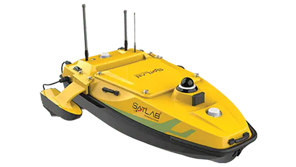
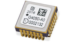 High-Dynamics MEMS Gyro
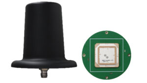 Anti-Jamming
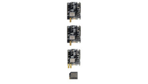 Triple-Band RTK Receivers
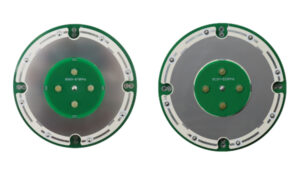 OEM GNSS Antenna
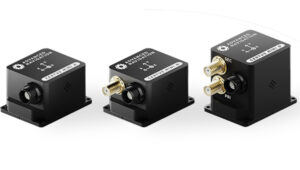 OEMs
OEMs Direct Georeferencing Solution
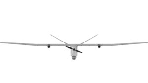 Fixed-Wing UAV
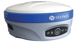 GNSS Receiver
 USV
USV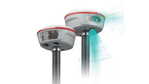 Laser RTK
 UAV Lidar Scanner
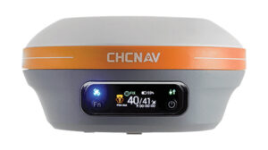 Receiver
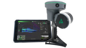 Software Solution