
Florian Ollier, head of marketing and communications, SBG Systems, talks about the company’s new releases and more from INTERGEO 2023.
Tag: SBG Systems
-

INTERGEO 2023: Recap

On the first day of INTERGEO 2023, attendees flooded the exhibit hall. (All photos taken by GPS World staff). The 29th INTERGEO conference and trade show on geospatial technology and data was held from October 10 to 12 in the German capital Berlin. This year’s event took place under the famous radio tower and in the brand new Hub27 conference center, part of the 42-acre Messe Berlin exhibit and conference center. The annual event takes place each year in a different German city.
Over the three days, 560 vendors from more than 40 nations exhibited their products, while people from across the globe attended presentations and vendor exhibits on geodesy, geoinformation and land management. Topics covered included Earth observation and environmental monitoring, maritime solutions, unmanned systems, building information modeling (BIM), GIS and artificial intelligence, metaverse and cloud applications, smart cities, digital twins, COPERNICUS and Galileo satellite services, 4D geodata, 3D cadaster, and smart mapping applications. The focus was on how these technologies and data are used to address issues of housing, mobility, sustainability, climate change and internal security, monitoring for disaster prevention and protection, and the creation of more equitable living conditions.
In conjunction with the conference, the German Cartography Congress 2023 also convened, with lectures on such topics as atlases, map collections, map design, and artificial intelligence. In her keynote address, Professor Monika Sester discussed how machine learning methods help with generalization and Professor Sebastian Meier gave a provocative lecture titled “Critical Cartography in Times of Hallucinating Machines.”

Attendees at a presentation from the exhibit hall stage. Day 1, Tuesday, October 10
On the first day of INTERGEO 2023, keynote speakers included Jack Dangermond, founder and CEO of ESRI, professor Paul Becker, president of the Federal Agency for Cartography and Geodesy, Scott Crozier from Trimble and professor Rudolf Staiger, president of the organiser DVW e.V. The main theme was the centrality of geospatial science and technology to sustainability because the basis of socially, ecologically and economically sustainable decisions lies in the understanding of the Earth system. This is increasingly achieve using geoinformation gathered through Earth observation and many other sensors.
GPS World conducted short interviews with Gustavo Lopez, market access manager at Septentrio and Deyn Deng, overseas sales manager at Unicore.

Some surveying supplies that have been used for centuries are still in use today. Day 2, Wednesday, October 11
On the second day of INTERGEO 2023, the focus of the keynote presentations, like that of many of the products in the exhibit hall, was “smart cities” and building information modeling (BIM), including a panel discussion on the importance of BIM in Germany. Related themes discussed in the presentations, on the exhibit hall stages, and at vendors’ booths included connected urban twins, sensor data, real-time applications, urban twins as drivers of innovation for local governments, maritime solutions, Earth observation, and unmanned systems.

An autonomous bathymetric vessel from Teledyne Marine. At a press conference on navigating sustainability through geospatial insights the participants were Rudolf Staiger, president of DVW, Boris Skopljak, Vice President survey & mapping strategy and product marketing at Trimble, Thomas Harring, president Geosystems at Hexagon, Gerd Buziek, Business Relations Executive at Esri Deutschland and Godela Roßner, head of Earth observation at Deutsches Zentrum für Luft- und Raumfahrt (DLR).
This UAV from CHCNAV can take off and land like a helicopter and fly like a plane. GPS World conducted short interviews with Andrew Scott, Head of Marketing & Sales at JAVAD GNSS; Jamie Birch, product manager at OxTS; Mandy Clayton, Southeast Regional sales mganager at GeoMax (part of Hexagon); Florian Ollier, head of marketing & communications at SBG Systems; Andrei Gorb, division product manager, Mapping Solutions at CHCNAV; Rachel Wong, Survey & Engineering Product Line, product manager at CHCNAV; Marcel Visser, CEO of NavCert; Ken MacLeod, product line manager and Bruce Shields systems group director at Tallysman; and Morgane Selve, head of marketing at Yellowscan.
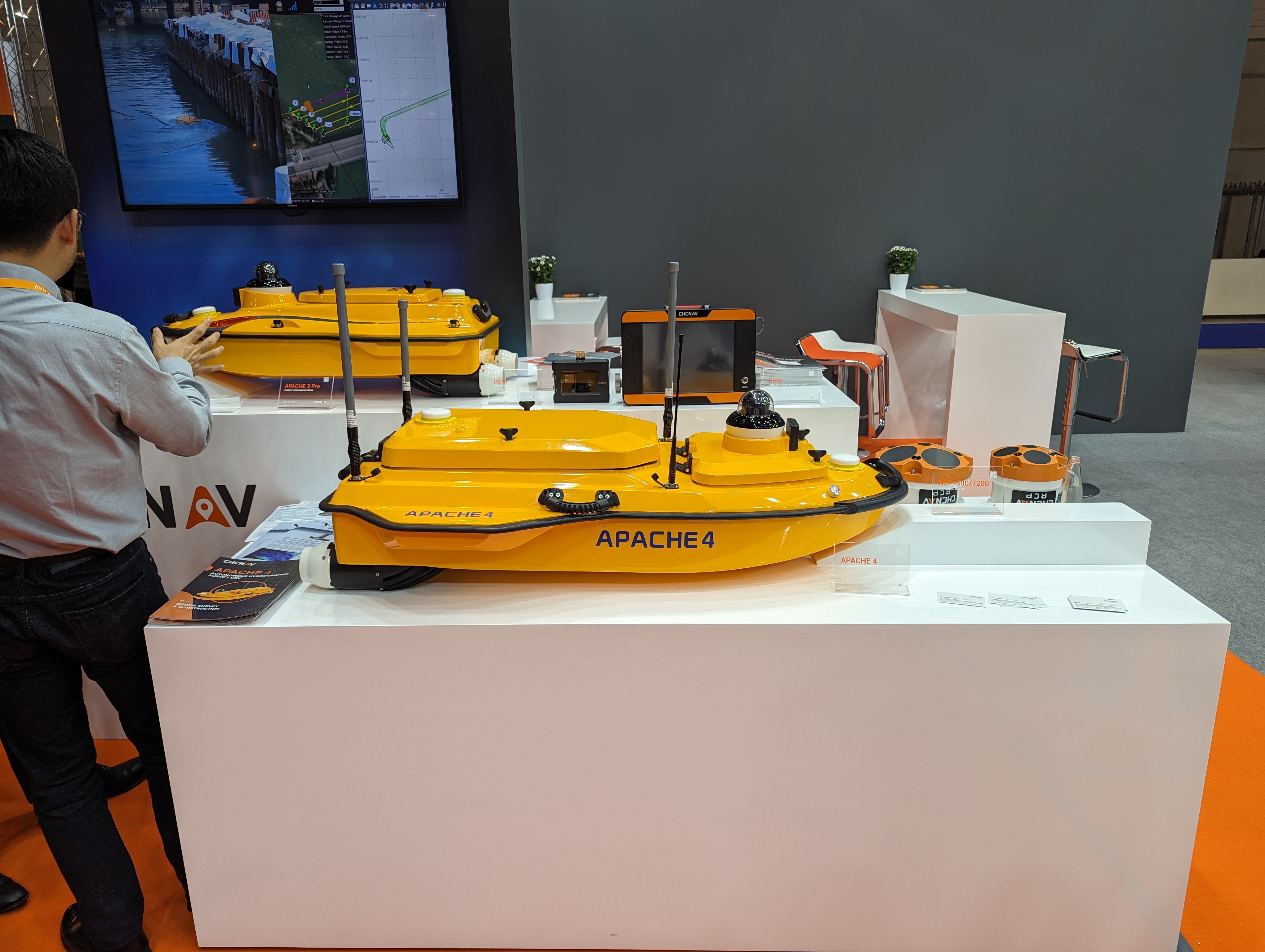
CHCNAV’s Apache 4 autonomous bathymetric vessel. Visser told GPS World that his company had obtained from the German federal government sole responsibility to certify UAVs in Germany for commercial operations, including flights beyond visual line of sight (BVLOS).

Trimble’s GEDO CE 2.0 track measurement trolley. -
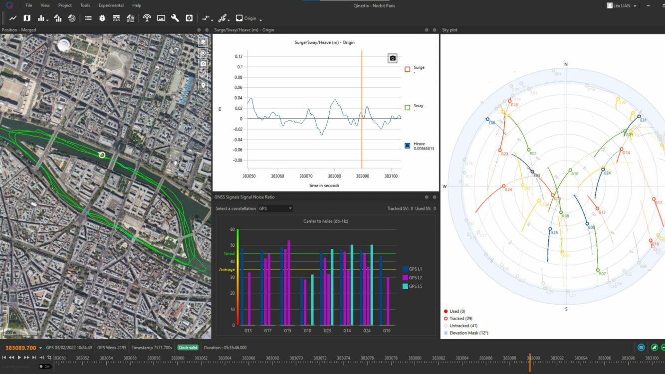
SBG Systems unveils Qinertia 4
Image: SBG Systems SBG Systems will release the newest version of its Qintertia technology, Qinertia 4, on November 7, 2023. This version introduces several innovative features that provide users with a complete solution for precise trajectory and motion analysis.
Qinertia is a post-processing software delivering better precision and reliability compared to RTK systems. Qinertia 4 has an enhanced Geodesy engine to boasts an extensive selection of preconfigured coordinate reference systems (CRS) and transformations, making it a versatile solution in applications that use diverse geodetic data, including land surveying, hydrography, airborne surveys, construction and more.
To tackle the challenges of variable ionospheric activity, the new technology uses Ionoshield PPK mode. This feature compensates for ionospheric conditions and baseline distances, allowing users to perform post-processing kinematics (PPK) even for long baselines or harsh ionospheric conditions.
Another addition to Qinertia 4 is extended continuously operating reference stations (CORS) network support. This feature offers users a vast network of 5000 SmartNet for reliable GNSS data processing.
Qinertia has more than 10,000 bases in 164 countries. This global coverage ensures that Qinertia remains a reliable and efficient solution, regardless of geographic location. In addition, users can import their own base station data and verify its position integrity with precise point positioning (PPP).
For data that cannot be processed using PPK, Qinertia 4 offers an alternative solution with its new tightly coupled PPP algorithm. This new processing mode, available for all users with active Qinertia maintenance, provides post-processing anywhere in the world without a base station, with a horizontal accuracy of 4cm and a vertical accuracy of 8cm.
Qinertia’s new functionalities will be demonstrated live at Intergeo 2023 in Berlin.
-

OEMs take tech to the next level
OEM products are vital to many industries. Companies such as Septentrio and SBG Systems design and produce a variety of OEM devices for many different applications. (Image: sankai/E+/Getty Images) OEM devices are an integral part of many applications requiring precise positioning technology. As the OEM market grows and performance requirements become more demanding, it is critical for OEM devices to be reliable, accurate, and easy to integrate. From precision agriculture, to surveying and mapping, to UAV missions, there are OEM devices on the market suitable for demanding applications.
Survey and Map Like a Pro
Surveying and mapping is one area in which OEM boards are embedded deep in many products. Septentrio designs and manufactures multi-frequency, multi-constellation, GPS/GNSS positioning technology and offers a variety of OEM products for demanding applications.
Image: Septentrio The AsteRx-m3 Pro is an ultra-low power GNSS rover receiver. It is compact and high-performance, making it suitable for integration into high-precision industrial applications. It incorporates multi-frequency, multi-constellation GNSS technology as well as anti-jamming algorithms for availability and reliability. The AsteRx-m3 Pro features AIM+ advanced anti-jamming and anti-spoofing technology as a part of Septentrio’s GNSS+ Technology Suite.
This receiver is designed for rover (mobile) applications, making it an easy-to-integrate solution for any kinematic application where reliable high-accuracy positioning is needed. It is available in single or dual antenna mode, for high quality heading and pitch, or heading and roll information.
GNSS heading is available directly from initialization and removes reliance on vehicle dynamics or magnetic sensors. This is an optional feature.
“Septentrio OEM receivers come in a variety of form factors, from compact modules to credit-card boards,” Danilo Sabbatini, OEM product manager at Septentrio, stated. “Our multi-frequency OEM receiver portfolio includes products that fit various user needs from purely rover GNSS high accuracy positioning to heading receivers, as well as GNSS/INS boards for inertial navigation or mapping.”
Image: Septentrio Aside from surveying and mapping, the AsteRx-m3 Pro is suitable for assured position, navigation and timing (PNT), autonomous vehicles, precision agriculture, logistics and port operations, mining and construction, rail, robotics, space and UAV applications.
Plowing the Way
The increase in demand for food due to population growth challenges farmers to increase production. To help them do this, Septentrio is working with manufacturers of agricultural machinery to enable them to achieve centimeter-level positioning accuracy.
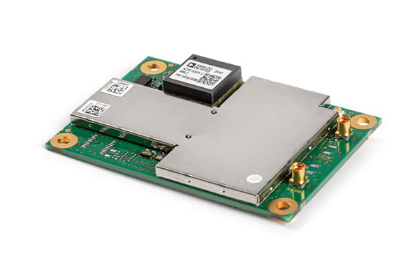
Image: Septentrio The AsteRx-i3 D Pro is a ready-to-use GNSS/INS single-board receiver that delivers reliable centimeter-level positioning combined with 3D orientation (heading, pitch and roll) in demanding environments. Its inertial sensor provides orientation and positional dead-reckoning, making it suitable for systems that require continuous positioning even during short GNSS outages. It provides reliable and accurate positioning by enhancing GNSS with an inertial measurement unit (IMU).
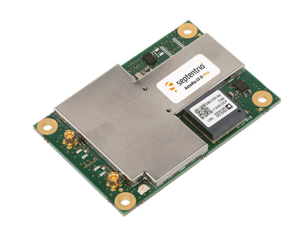
Image: Septentrio The AsteRx-i3 D Pro is quad-constellation and multi-frequency. It provides all-in-view real-time kinematic positioning and features AIM+ unique interference monitoring and mitigation system and other advanced GNSS+ algorithms.
Like the AsteRx-m3 Pro, the AsteRx-i3 D Pro is also suitable for assured PNT, autonomous vehicles, logistics and port operations, mining and construction, rail, robotics, space, survey and mapping, and UAV applications.
For more information about Septentrio’s OEM boards, click here.
Flying High
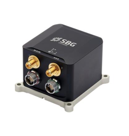
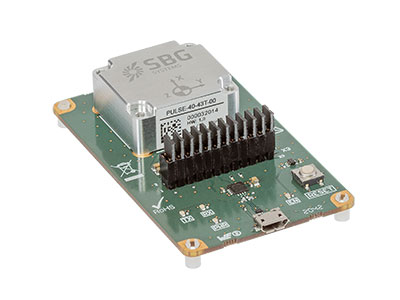
SBG Systems has released Ekinox Micro, a compact and rugged high-performance inertial navigation solution designed to deliver accuracy in challenging environments. Ekinox Micro combines a high-performance MEMS tactical inertial sensor with a quad-constellation, dual-antenna GNSS receiver, making it suitable for mission-critical applications.
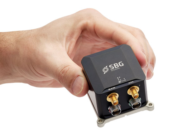
Image: SBG Systems GPS World caught up with Yoann Plénet, head of products at SBG Systems, at AUSVI XPONENTIAL in May. He elaborated on Ekinox Micro’s key markets and features.
“This is Quanta Micro in a box with the same performance and the same benefits that you get [with the Quanta Micro]: inertia, enhanced GNSS, and complement[ing] the GNSS,” Yoann said. “At the same time, we are targeting very rough environments, especially larger drones which are most likely military ones. So, [Ekinox Micro] is a very rugged product.”Ekinox Micro includes pre-configured motion profiles for land, air and marine applications, enabling the sensor and algorithms to be tuned for maximum performance in any condition. The device is designed for ease of use and integration, with simple connectors, a web configuration interface, a datalogger, Ethernet connectivity, a PTP server, a REST API for configuration, and multiple input and output formats.
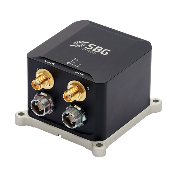
Image: SBG Systems Ekinox Micro is compatible with real-time kinematic (RTK) and based on a tactical 0.8°/h class inertial measurement unit calibrated across the entire operating temperature range. It features accuracy roll/pitch of 0.015°, accuracy heading of 0.035°, and accuracy position of 1.2 m without any corrections or 1 cm in RTK.
Yoann also said that with the rise of jamming and spoofing, Ekinox Micro is designed with enhanced technology to mitigate those threats.
“Jamming and spoofing is ongoing and is an issue for more and more of our clients. So, we have worked a lot — and that is something that is beneficial to all of our product ranges — on enhancing our algorithms and our technology so we can better detect jamming and spoofing than we could before,” Yoann said.
Ekinox Micro will be commercially available in September. Click here for more information on Ekinox Micro.
Bonus Device

Image: Septentrio The Septentrio mosaic-X5 is a multi-band, multi-constellation GNSS receiver in a low power surface mount module with a wide array of interfaces. It is designed for mass market applications such as robotics and autonomous systems — capable of tracking all GNSS constellations, supporting current and future signals.
The mosaic-X5 has an update rate of 100 Hz, is easy to integrate, and is optimized for automated assembly.
Antoon De Proft, Septentrio’s CEO, mentioned in the April 2023 issue of GPS World the company’s innovation in Leuven, Belgium.“Septentrio’s 20 years of experience in GNSS technology as well as our strategic partnership with the European Space Agency and close collaboration with the IMEC semiconductor technology hub has enabled us to produce the mosaic-X5 receiver,” he said. “This compact module is one of the highest performing and resilient GNSS receivers on the market. It is used in a wide array of applications, especially where the position is mission critical. Examples include a wide variety of autonomous devices, including drones that benefit from mosaic’s lightweight and low-power design.”
Francois Freulon, head of product management, added, “Reliability and resilience to GNSS vulnerabilities is a key pillar on which we base our receiver design. RF interference in the form of jamming and spoofing* is increasingly common, which is why we are investing heavily in securing our receivers at the core with the latest hardware and software techniques. In addition to the AIM+ patented technology, the mosaic module already includes OSNMA functionality, which will offer end-to-end authentication on Galileo’s civilian signals, protecting receivers from GNSS spoofing attacks.”
For more information about Septentrio’s mosaic GPS/GNSS modules, click here. -

GPS World takes flight: XPONENTIAL 2023
Photo: Maddie Saines On May 8-11, GPS World staff attended the AUVSI XPONENTIAL show at the Colorado Convention Center in downtown Denver. There were more than 600 booths in the exhibit hall, and the staff was able to visit several of the exhibitors, including Tualcom, SBG Systems, Inertial Labs and Honeywell. They also attended educational sessions lead by industry leaders and participated in insightful discussions about the future of UAVs and overall autonomy. For highlights from XPONENTIAL, click here.
-
Launchpad: New antennas, scanners and survey applications
A roundup of recent products in the GNSS and inertial positioning industry from the June 2023 issue of GPS World magazine.
SURVEYING
Survey Software
Georeference raw lidar dataGeoreferencer 2.5 featuring anyNAV software is suitable for survey applications. Users of Georeferencer 2.5 with the anyNAV feature enabled can boresight payloads and georeference lidar data using the user’s navigation data. The anyNAV software enables lidar surveyors to create accurate point clouds quickly. Georeferencer 2.5 now takes navigation data from third-party inertial navigation systems, which enables users to use that data to georeference raw lidar data from multiple sensor families. The resulting data can then be viewed in many point cloud viewer software packages.
OxTS, oxts.com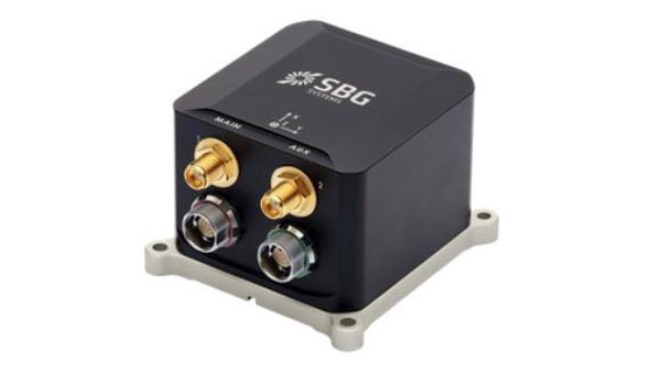
Inertial Navigation Solution
Designed to deliver accuracy in challenging environmentsEkinox Micro combines a high-performance MEMS tactical inertial sensor with a quad-constellation, dual-antenna GNSS receiver, making it suitable for mission-critical applications. The device includes pre-configured motion profiles for land, air and marine applications, enabling the sensor and algorithms to be tuned for maximum performance in any condition. The device is designed for ease of use and integration, with simple connectors, a web configuration interface, datalogger, Ethernet connectivity, a PTP server, a REST API for configuration, and multiple input and output formats. Ekinox Micro is compatible with real-time kinematic (RTK) solutions and based on a tactical 0.8°/h class inertial measurement unit calibrated across the entire operating temperature range. It features accuracy roll/pitch of 0.015°, accuracy heading of 0.035°, and accuracy position of 1.2 m without any corrections or 1 cm in RTK. The device also meets the MIL-STD-461, MIL-STD-1275, and MIL-STD-810 standards.
SBG Systems, sbg-systems.com
Lidar Sensor
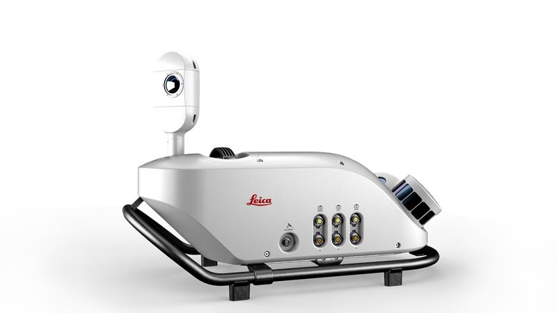
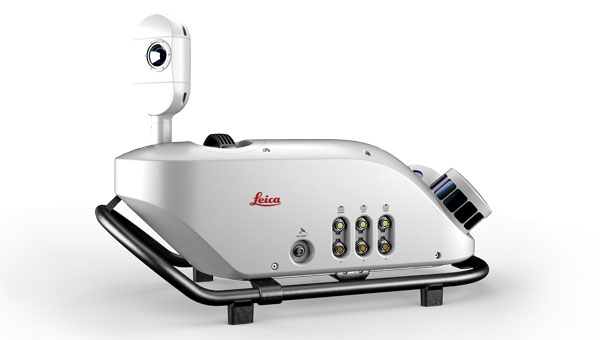
High-performance airborne bathymetric solution for deep water surveyingThe HawkEye-5 increases survey efficiency by up to 25% compared to previous generations. The technology expands the capabilities of the Chiroptera-5 bathymetric lidar system, enhancing the productivity of applications such as nautical charting, environmental monitoring, and maritime surveillance in deep waters. The technology is designed to fit the Leica PAV100 gyro-stabilized mount, which isolates the sensor from unwanted aircraft movements — resulting in consistent data density and more efficient area coverage. The HawkEye-5 combined with the Chiroptera-5 features three lidar sensors, one four-band camera, and a QC camera to collect data from the seabed to land.
Leica Geosystems, leica-geosystems.com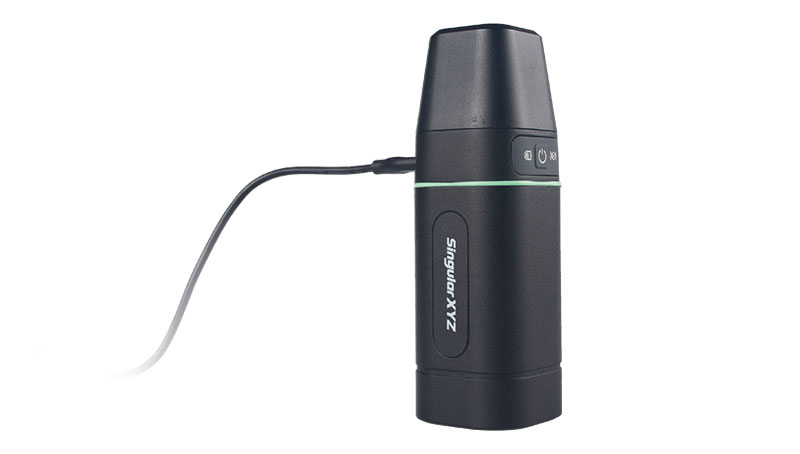
GNSS Receiver
Complete with network RTK roverThe Sfaira One GNSS receiver is small and centimeter accurate. It provides users with an entry-level network real time kinematic (RTK) rover. Sfaira One is equipped with a GNSS module with 1,408 channels for GPS, BDS, GLONASS, Galileo and QZSS tracking — providing centimeter positioning in harsh environments. It also features advanced RTK and an anti-interference algorithm. The GNSS receiver connects via Bluetooth and can be configured to conduct surveying tasks on a smartphone. Additionally, Sfaira One supports SingularPad and SingularSurv software and is also compatible with mainstream field survey or GIS software. Sfaira One is IP65 dustproof and waterproof, which makes the receiver suitable for all weather conditions. It has a 4,800 mAh battery life with 16 hours working time and type-C interface that can be charged on-the-go with a power bank.
SingularXYZ, singularxyz.com
MAPPING
Mobile Mapping Solution
Built for large-scale infrastructure measurement and digital twin creationThe Pegasus TRK100 is small and light, making it easy to mount on any vehicle. The mobile mapping system features the same modular hardware approach that enables users to add more cameras to expand the range of use cases. With its advanced mapping capabilities, the Pegasus TRK100 enables GIS professionals to visualize and understand the location of assets to help make the right decisions, improve asset management, and support infrastructure building and maintenance. The Pegasus TRK100 combines artificial intelligence and a learning algorithm to enhance and optimize the clarity of points in post-processing for improved accuracy. The versatility of the Pegasus TRK100 suits a variety of applications in diverse industries, including telecommunications, utilities and road maintenance.
Leica Geosystems, leica-geosystems.com
OEM
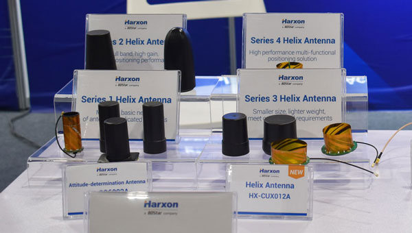
Photo: Helix Antenna Series
Suitable for unmanned system applicationsHX-CUX012A is designed with an extremely low profile, making it suitable for integration into UAVs, surveying and monitoring devices. It reduces the overall weight of applications, enables multipath mitigation and more. HX-CUX005A is a solution for integrated helix antenna applications. It is designed with the integration of a GNSS antenna and Bluetooth/Wi-Fi antenna, enabling communication and navigation without mutual interference. HX-CH7609A is a low profile and small size housed helix antenna. It has comprehensive GNSS support including GPS, GLONASS, Galileo, BeiDou, as well as L-band correction services. HX-CH7609A features centimeter phase center repeatability and high gain at a low elevation. With signal filtering and multipath rejection, it provides reliable and stable GNSS signals. HX-CHX600A is a high-performance helix antenna that receives GPS, Galileo, BeiDou, GLONASS, as well as L-band signals. With 4.2 dBi high gain, it provides suitable tracking performance at a low elevation angle. Its low noise figure design reduces transmission interference and improves signal quality.
Harxon, en.harxon.com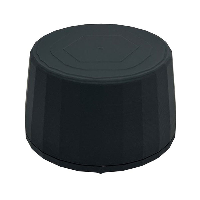
Helical Antenna
Suitable for UAV applicationsThe HC990XF helical antenna is designed for precise positioning, covering the GPS/QZSS L1/L2/L5, QZSS L6, GLONASS G1/G2/G3, Galileo E1/E5a/E5b/E6, BeiDou B1/B2a/B2b/B3, and NavIC L5 frequency bands. This includes the satellite-based augmentation system (SBAS) available in the region of operation as well as L-band correction services. The HC990XF has a base diameter of 64 mm, is 37 mm tall and weighs 45 g. Its precision-tuned helical element provides full GNSS band coverage, suitable gain and axial ratio, and a tight phase center. The antenna base has an SMA (male) connector, three screw holes for secure attachment and an O-ring to waterproof the antenna connector. The HC990XF helical design does not require a ground plane, making it a suitable antenna for UAV applications.
Tallysman Wireless, tallysman.com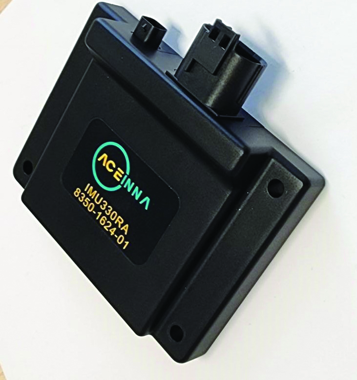
Inertial Module
For automotive usesThe ASM330LHB automotive-qualified MEMS inertial-sensing module provides accurate measurements for a wide variety of vehicle functions. With the dedicated software provided, ASM330LHB also addresses functional-safety applications up to ASIL B1. ASM330LHB contains a 3-axis digital accelerometer and 3-axis digital gyroscope that provides a six-channel synchronized output. The module’s high-accuracy inertial measurements are used to improve the precise positioning of a vehicle. The accelerometer and gyroscope maintain high stability over time and temperature, and have very low noise for an overall bias instability of 3°/hour. Specified over the extended temperature range, -40°C to 105°C, the ASM330LHB has multiple operating modes that let designers optimize the data-update rate and power consumption.
ASM330LHB can support advanced driver assistance systems or vehicle-to-everything communication, as well as help stabilize sensing systems such as radar, lidar and visual cameras, and assist semi-automated driving applications up to L2+. Additionally, ASM330LHB can be used to enable a variety of functionalities in the body of a vehicle. ASM330LHB was developed with the automotive functional-safety standard ISO 26262 — the ASIL B compatible software library has been certified independently by TÜV SÜD. By implementing dedicated safety mechanisms, including data integrity and accuracy, the library ensures compliance with ASIL B automotive systems.
With the companion software engine, the ASM330LHB supports the growing adoption of automotive systems that require safety integrity up to level B. The combination of two ASM330LHB sensor modules for fail-safe redundancy delivers resilient contextual data for driver-assistance applications such as lane centering, emergency braking, cruise assistance and semi-automated driving. ASM330LHB is AEC-Q100 qualified and in production now in a 2.5 mm x 3.0 mm 14-lead VFLGA package.
STMicroelectronics, st.com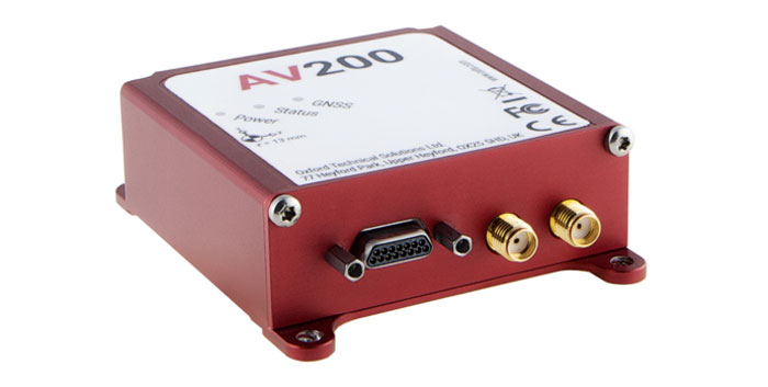
INS
Built for automation applicationsThe AV200 is designed to give precise location data. It includes quad-constellation, dual-antenna, real-time kinematic (RTK) GNSS to provide users with position data as well as its temperature-calibrated, multi-core inertial measurement unit. These technologies give the AV200 position accuracy within 0.05 m, heading accuracy of 0.2°, and velocity accuracy of 0.2 km/h. The AV200 is built using the same technology that is commonly used for NCAP test validation, which has become the preferred technology for OEMs globally to test vehicles in both test-track and real-world scenarios.
OxTS, oxts.com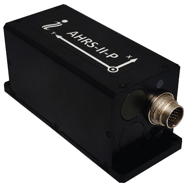
Reference System
For attitude and headingAHRS-II-P is an enhanced, high-performance strapdown system that determines absolute orientation (heading, pitch and roll) for any mounted device. The AHRS-II-P can determine orientation for both motionless and dynamic applications. The AHRS-II-P contains a tactical-grade inertial measurement unit (IMU) consisting of three high-precision MEMS accelerometers, three advanced MEMS gyroscopes and a high-precision, gyro-compensated, embedded fluxgate compass. It also uses 8 mm fluxgate magnetometers. This device is suitable for a variety of devices such as UAVs, antennas, ships and robotic devices.
Inertial Labs, inertiallabs.comGNSS Receiver
For accurate positioning and heading
As a high-precision integrated GNSS positioning and heading receiver, the A200 can track all existing and planned constellations — including GPS, BSD, GLONASS, Galileo, QZSS and SBAS — providing high-precision positioning and heading data for users. A200 is designed specifically for precision agriculture, machine control, fleet management, robot and other industries. The A200 is equipped with a K823 GNSS module. It also features 1,226 channels. The A200’s third generation IMU delivers fast initialization and ensures the output of heading during temporary GNSS signal loss. The built-in data link has low power consumption and a long working range. It also can be upgraded to a super-long-range data link module.
ComNav Technology, comnavtech.com -

XPONENTIAL 2023: First day recap
Attendees crowded the show floor during the first day of AUVSI XPONENTIAL 2023. AUVSI XPONENTIAL is underway in Denver, Colorado, at the Colorado Convention Center. After the first day of touring the XPO Hall of more than 600 exhibits and attending educational sessions lead by industry leaders and speakers, GPS World staff noticed a key theme: mitigating GNSS jamming and spoofing by advancing technology for UAVs.
Educational Sessions

Franck Boynton, Vice President of NavTachGPS, highlighted Tallysman ‘s HC871SXF during his “Real World GPS/GNSS Protection from Start to Finish,” presentation. “Real World GPS/GNSS Protection from Start to Finish,” was presented by Franck Boynton, Vice President of NavTechGPS. He discussed why anti-jam equipment is needed and how to mitigate jamming. Boynton mentioned several anti-jam products, such as NovAtel’s OEM series product line, Septentrio’s AIM+, Tallysman’s HC871SXF and more.
Additionally, GPS World contributing writer, Dana Goward, received a mention for his article regarding the GPS jamming incident on Jan 21, 2022, at Denver International Airport, which can be found here. Boynton also suggested checking out the RNT Foundation, which is a nonprofit, public benefit corporation that helps protect critical infrastructure by promoting resilient navigation and timing, of which Goward is the president and director.

“The Importance of GNSS Security in UAV Applications,” featured a panel of speakers that included (from left to right) Captain Joe Burns, CEO of the Airo Group and member of the National Space-Based Positioning, Navigation and Timing Advisory Board, Jeff Horne, vice president of security at Skydio Abigail Smith, executive director of UAS security at the FAA, Gustavo Lopez, market access manager at Septentrio, and moderated by Michael Glutting, sales manager at Septentrio. “The Importance of GNSS Security in UAV Applications,” featured a panel of speakers that included Abigail Smith, executive director of UAS security at the FAA, Captain Joe Burns, CEO of the Airo Group and member of the National Space-Based Positioning, Navigation and Timing Advisory Board, Gustavo Lopez, market access manager at Septentrio, Jeff Horne, vice president of security at Skydio, and moderated by Michael Glutting, sales manager at Septentrio. During the panel discussion, the speakers explained types of GPS interference, including jamming and spoofing, and the risk they pose to UAVs. The latest methods for strengthening both GNSS receivers and control units to design secure and robust UAVs was also discussed.
Day-of highlights
Maddie Saines, managing editor, and Jesse Khalil, digital media specialist, had the opportunity to stop by several booths in the XPO Hall on the first day of XPONENTIAL. A few highlights from the day included speaking with Ahmet Salih Erdem, deputy general manager at Tualcom, getting an in-depth look at SBG Systems’ Quanta Mirco and Ekinox Micro with Yoann Plenet, head of product management, and getting a first-hand look into the newest products from Tallysman Wireless — such as SSL889XF — from Ken MacLeod, product manager for Tallysman.
SBG System’s Quanta Mirco and Ekinox Micro. 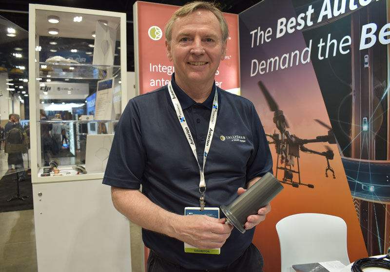
Ken MacLeod, product manager for Tallysman, showcasing the AJ977XF. 
Tualcom’s booth at XPONENTIAL 2023 showcased new products such as ANTY, its GPS anti-jamming device. -
SBG Systems unveils miniature GNSS-aided inertial navigation solution
Image: SBG Systems SBG Systems has released the Ekinox Micro, a compact and rugged high-performance inertial navigation solution designed to deliver accuracy in challenging environments. Ekinox Micro combines a high-performance MEMS tactical inertial sensor with a quad-constellation, dual-antenna GNSS receiver, making it suitable for mission-critical applications.
Ekinox Micro includes pre-configured motion profiles for land, air, and marine applications, enabling the sensor and algorithms to be tuned for maximum performance in any condition. The device is designed for ease of use and integration, with simple connectors, a web configuration interface, a datalogger, Ethernet connectivity, a PTP server, a REST API for configuration, and multiple input and output formats.
Ekinox Micro is real-time kinematic (RTK) compatible and based on a tactical 0.8°/h class inertial measurement unit calibrated across the entire operating temperature range. It features accuracy roll/pitch of 0.015°, accuracy heading of 0.035°, and accuracy position of 1.2 m without any corrections or 1 cm in RTK.
-

SBG Systems now compatible with Marinestar corrections
Credit: SBG Systems The latest versions of Ekinox, Apogee, and Navsight from SBG Systems are now fully compatible with the Fugro Marinestar G4+ precise point positioning (PPP) solution.
Fugro Marinestar G4+ is a solution that uses satellite-based augmentation to deliver centimetric positioning accuracy without depending on a local base station. This product is suitable for maritime operations where precise positioning is important.
With this compatibility, users can now use Marinestar correction with SBG products both via L-Band or NTRIP distribution.
The combination of high-performance correction with inertial measurements from SBG Systems enables users to achieve accuracy in attitude and position for maritime applications. This is suitable for applications such as marine construction, dredging, hydrography and more.
-
Launchpad: GNSS receivers, timing modules, survey applications
A roundup of recent products in the GNSS and inertial positioning industry from the April 2023 issue of GPS World magazine.
TIMING
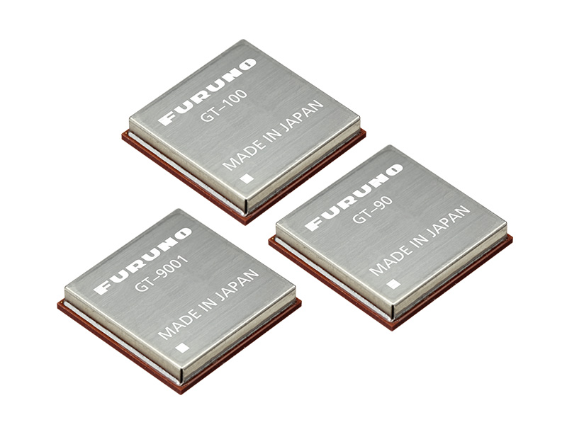
Image: Furuno Global Timing Module
Supports L1 and L5 GNSS signalsGT-100 is compatible with all GNSS constellations. The GT-100 realizes high robustness and standard of time accuracy and stability. The GT-100 features advanced multipath mitigation, anti-jamming and anti-spoofing as well as short-term holdover, ensuring superior performance even if L1 or L5 are jammed. The module delivers nanosecond precision for 5G wireless systems, radio communications systems, smart power grids and grand master clocks. Along with the GT-100, GT-9001 and GT-90 achieve a level of time stability of 4.5ns (1σ) and offer superior features and performance.
Furuno, furuno.com
Image: UTStarcom PTP Grandmaster
Designed for mobile networksThe SyncRing XGM30E precision time protocol (PTP) grandmaster is designed for mobile networks and other applications requiring accurate time and frequency synchronization. It is an addition to the SyncRing line of network synchronization equipment. The SyncRing XGM30E is an indoor PTP grandmaster offering echo time accuracy of more than ±40 ns, which can meet the stringent timing requirements of demanding applications, including 4G and 5G networks. The clock complies with the PTP IEEE 1588-2008 standard, supporting major ITU-T frequency and phase and time profiles. SyncRing XGM30E supports synchronous Ethernet (SyncE) output on all service interfaces for accurate frequency synchronization, and SyncE input for enhanced time holdover operation during GNSS outages. The grandmaster includes an indoor rack-mount design and power supply redundancy with AC or DC built-in options and has flexible management options. The SyncRing XGM30E is available now.
UTStarcom, utstar.com
Image: Huber+Suhner Copper-Free Data System
For precise timing synchronization for high-performance networksThe GNSS and Power over Fiber GPSoF System receives, transmits and expands GNSS timing signals for the purpose of timing synchronization in data centers, central offices, distributed antenna systems or enterprise applications. It enables greater distances between the radio frequency source and the receiver system. It is also immune to RFI, EMI and EMP, contains remote control and monitoring via a web interface, and supports infrastructure installation due to direct GNSS signal evaluation.
Huber+Suhner, hubersuhner.com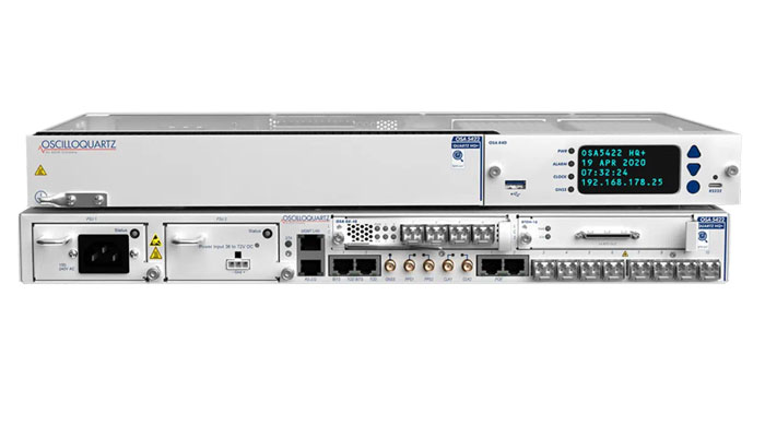
Image: ADVA M-Code Device
With advanced timing for military applicationsThe OSA 5422 grandmaster clock meets key requirements of military networks by providing advanced positioning, navigation and timing (PNT) capabilities and improved resilience. The OSA 5422 grandmaster clock is integrated with a highly reliable M-code receiver, which meets stringent frequency and phase synchronization needs. The device is equipped with multi-band, multi-constellation GNSS receivers for when M-code is not available. The OSA 5422 also has long holdover and precision time protocol backup, which enables it to maintain accurate timing even in the event of M-code disruption. The OSA 5422 supports legacy interfaces such as BITS and IRIG and features eight field-upgradable 10G bit/s ports and 1G bit/s interfaces. The device is suitable for most demanding military edge applications.
ADVA, adva.com; Brandywine Communications, brandywinecomm.com
AUTONOMOUS

Image: CHC Navigation GNSS RTK Steering System
Suitable for agriculture applicationsThe NX510 SE Auto-Steer is an automated steering system that retrofits several types of new and old farm tractors and other vehicles. It can be connected to local real-time kinematic (RTK) networks or GNSS RTK base stations. NX510 SE is a guidance controller powered by multiple corrections sources and five satellite constellations: GPS, GLONASS, Galileo, BeiDou and QZSS. It has a built-in 4G and UHF modem that connects to all industry-standard differential GPS and RTK corrections to achieve centimeter-accuracy steering. NX510 SE contains GNSS and inertial navigation system terrain compensation technology, which maintains high accuracy in challenging environments and terrain. This makes NX510 SE suitable for ditching, planting and harvesting applications. In addition, AgNav multilingual software, operating on a 10.1 in industrial display, supports multiple guideline patterns that include AB line, A+ line, circle line, irregular curve and headland turn.
CHC Navigation, chcnav.com
Image: Trimble Module for Rail Monitoring
For automated and semi-automated rail monitoringThe T4D Rail Module enables simple data collection and reduces office work required to automate movement detection for rail monitoring projects. The T4D software offers four main elements for automated monitoring: sensor management and data integration for GNSS; total station, geotechnical, vibration and environmental sensors; geodetic processing and adjustments for accurate results; analysis and visualization through several tools that provide real-time updates to support in-depth analysis and data presentation; and alarming and reporting. The T4D Rail module enables integration of rail as-builts collected with the Trimble GEDO system or with a track measuring bar paired with the Trimble Access Gauge Survey app. It also can automate calculations for track geometry parameters, generate analysis charts, and trigger alarms. The T4D software is offered in five editions to fit various project requirements. The editions include T4D Access, T4D Field, T4D Intermediate, T4D Geotechnical and T4D Advanced. T4D Access and T4D Advanced are the two editions that support the add-on Rail Module.
Trimble Geospatial, geospatial.trimble.com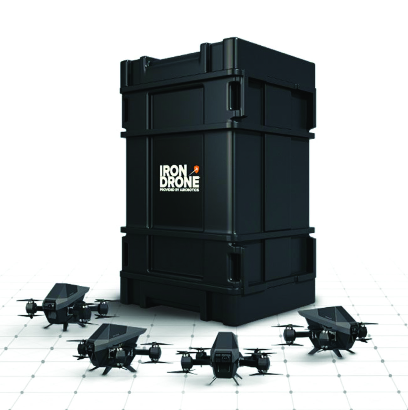
Image: Airobotics C-UAV Device
Anti-UAV protection deviceThe Iron Drone system is an advanced counter-UAV device, designed to defend against hostile drones in complex environments with minimal damage. Iron Drone is an automated intercepting system designed to eliminate small drones without using GPS or radio frequency jamming. The Iron Drone system is launched from a designated pod and flies autonomously towards targets under radar guidance. It identifies the target using computer vision capabilities. The intercepting UAV follows the target then uses a net and a parachute to incapacitate it, capture it and lower it to the ground.
Airobotics, airoboticsdrones.com
Image: Rohde & Schwarz Drone-based analyzer
For UAV inspectionsEVSD1000 VHF/UHF nav/drone analyzer provides highly accurate UAV inspection of terrestrial navigation and communications systems. The EVSD1000 VHF/UHF nav/drone analyzer is a signal-level and modulation analyzer for medium-sized UAVs. It features measurements of instrument landing systems, ground-based augmentation systems and VHF omnirange ground stations. The mechanical and electrical design is optimized for UAV-based, real-time measurements of terrestrial navigation systems with up to 100 measurement data sets per second. The analyzer provides high-precision signal analysis in the frequency range from 70 MHz to 410 MHz. This also includes the needed measurement repeatability to ensure that results from UAV measurements can be compared to flight and to ground inspections in line with ICAO standards. The EVSD1000 VHF/UHF nav/drone analyzer reduces runway blocking times, provides necessary measurement repeatability and offers measurement precision and GNSS time and location stamps. While streaming measurement data during a drone flight via the data link to a PC on the ground, the analyzer can also buffer data internally to ensure no results are lost if the data link is lost.
Rohde & Schwarz, rohde-schwarz.com
SURVEYING & MAPPING

Image: SiLC Coherent Vision Solution
Suitable for advanced productsThe Eyeonic Vision System is a frequency-modulated continuous wave lidar solution, which delivers high levels of vision perception to identify and avoid objects with low latency. At the core of the system is a fully integrated silicon photonics chip. It provides more definition and precision than legacy lidar solutions, with roughly 10 milli-degree of angular resolution coupled with millimeter-level precision. These features enable this solution to measure the shape and distance of objects with high-precision and at a large distance. The system combines the Eyeonic Vision Sensor and a digital processing solution based on a powerful field-programmable gate array. The flexible architecture enables synchronization of multiple vision sensors for unlimited points per second. The compact, powerful, vision solution is suitable for autonomous vehicles, smart cameras, robotics and other advanced products. It is available now. Pricing varies depending on configuration.
SiLC Technologies, silc.com
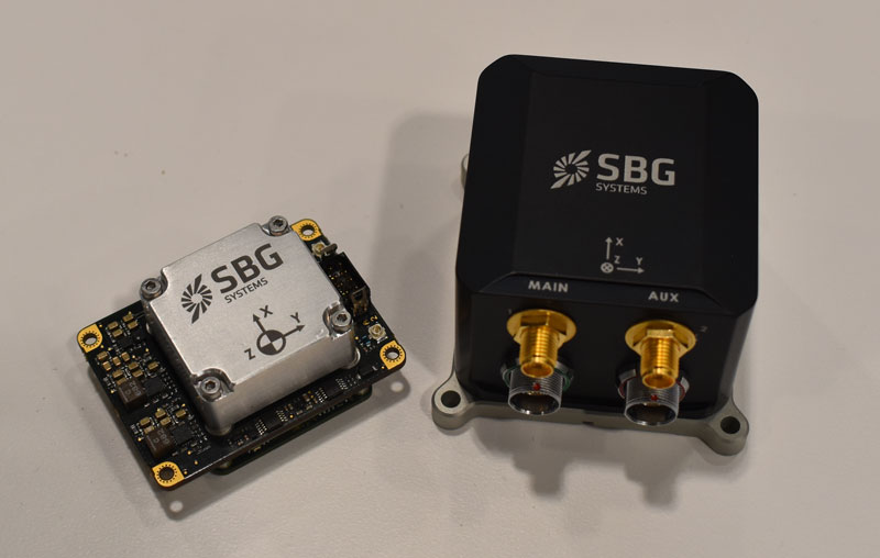
Image: SBG Systems GNSS-Aided INS
Easily integrated with lidar or other third-party sensorsQuanta Plus is a GNSS-aided inertial navigation system (INS). The device combines a MEMS inertial measurement unit (IMU) with a resilient GNSS receiver to get reliable position and attitude, as well as providing real-time kinematic (RTK) fixes. Quanta Plus includes motion profiles, which enable users to optimize the sensor parameters to suit different use cases. The built-in precise time protocol server ensures sub-microsecond synchronization with external devices such as lidar. The device also has a built-in datalogger, Ethernet interface for easy integration, and a web configuration interface for simple setup and control. The INS can be integrated with Qinertia, SBG System’s post-processing software. Qinertia improves the performance of acquired data during a mission using reliable RTK corrections from a wide range of continuously operating reference station networks, or by importing base-station data during the process. Quanta Plus also improves the accuracy of the position and attitude using forward and backward processing and by integrating a tight coupling between GNSS and IMU data.
SBG Systems, sbg-systems.com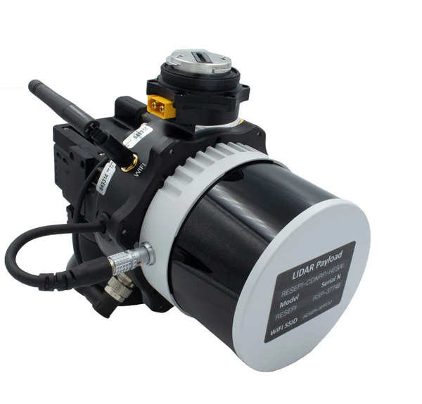
Image: Inertial Labs Survey Laser
Suitable for remote-sensing applicationsThe Resepi Hesai XT32 laser is designed for accurate remote-sensing applications. It can be used with commercially available lidar scanners, including Velodyne, Quanergy, Ouster, RIEGL, LIVOX and Hesai, as well as with UAVs. Resepi is completely modular, so users have full control for customization. The remote-sensing device uses a GPS-aided inertial navigation system with a NovAtel RTK/PPK single- or dual-antenna GNSS receiver, integrated with a Linux-based processing platform. It also comes with a 2 TB USB memory drive and has an embedded Wi-Fi cellular modem. Resepi has 3 cm to 5 cm point-cloud accuracy and can reach heights of more than 200 m above ground level. It is compatible with most UAV models; however, it is typically used with DJI M300, DJI M210 or DJI M600 models. The device is suitable for scanning and mapping, precision agriculture with lidar, simultaneous localization and mapping algorithm development, utility inspection and construction site monitoring. Resepi-supported software includes Hexagon NovAtel, PCPainter and PCMaster.
Inertial Labs, inertiallabs.com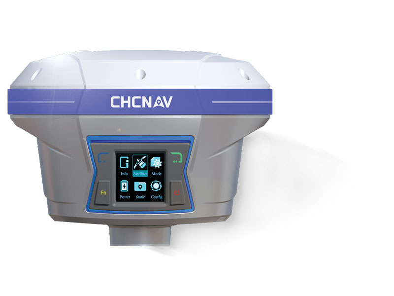
Image: CHC Navigation IMU-RTK GNSS Receiver
Provides robust and accurate positioningThe i90 GNSS receiver combines a GNSS real-time kinematic (RTK) engine, a high-end inertial measurement unit (IMU) sensor and advanced GNSS tracking capabilities to increase RTK availability and reliability. The embedded 624-channel GNSS receiver is compatible with GPS, GLONASS, Galileo and BeiDou signals. The i90 GNSS combines high-end connectivity modules: Bluetooth, Wi-Fi, NFC, 4G and a UHF radio modem. The internal UHF radio modem allows long-distance base-to-rover surveying up to 5 km. The built-in IMU ensures interference-free and automatic pole-tilt compensation in real time. An accuracy of 3 cm is achieved with pole-tilt range of up to 30°. The i90 GNSS receiver is suitable for construction and land surveying projects.
CHC Navigation, chcnav.comImage: CHCNAV Field Application
For Android devicesLandStar8 is designed to be flexible and user-friendly for surveying and mapping tasks. It is versatile, modular and customizable for topographic tasks such as surveying, stake out, cadastral, mapping and geographic information systems (GIS). Building on the legacy of LandStar7, the LandStar8 provides features such as a refined user interface, streamlined workflows, faster operation, and integrated cloud services. Cloud connectivity is built in for backup, data storage or remote technical support. LandStar8 has a simple and intuitive layout with large map windows and sharp graphics. Users can hide features they rarely use and display only those they need. They also can copy coordinate settings, control and staking points from another handheld controller by scanning a QR code. Projects can be edited and sorted by history and attributes. Custom coordinate systems, geoid models and coding libraries can be updated at any time by using resource packages. LandStar8 also features a terrain calibration wizard designed for non-expert users.
CHCNAV, chcnav.com
Image: Position Partners Survey Rover
For accurate, survey-grade aerial mapping and photogrammetrySmartSurveyor facilitates accurate, survey-grade aerial mapping and photogrammetry without the need for a connection between a camera shutter and a GNSS receiver. The fully compact, handheld aerial mapping survey rover is compatible with DJI Mavix 2 and 3 series and Phantom 4 Pro UAVs. The design is dissimilar from other UAV mapping systems in that it works from a UAV or smartphone and with two or more ground control points (GCPs) while using an ultra-matching technique. Once SmartSurveyor captures data, all photos and the GNSS file are uploaded to a PC and analyzed through the Agisoft UltraMatch workflow to confirm their accuracy before they are exported. Data can be managed in the cloud or on a local PC using software designed by MapSender. Additionally, this mapping tool works in tandem with the AllDayRTK subscription GNSS network service so that collected data can be uploaded to Tokara to remotely manage a project.
Position Partners, positionpartners.com
OEM
NB-IoT Industrial Module
Complete with GNSS geo-location capabilities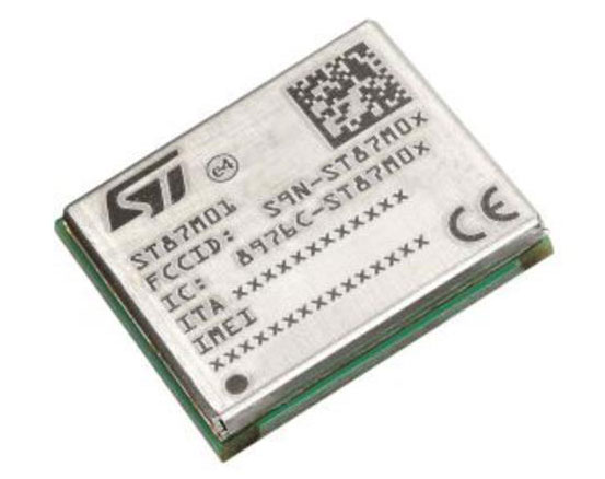
Image: STMicroelectronics The ST87M01 is a fully programmable, certified LTE Cat NB2 NB-IoT industrial module that covers worldwide cellular frequency bands and integrates advanced security features. The ST87M01 is an integrated native GNSS receiver with multi-constellation access, which ensures enhanced and accurate localization. The module has a diminutive 10.6 mm x 12.8 mm land grid array footprint, making it suitable for applications where a small form factor is key. The STM8701 offers flexibility for product developers, presenting a fully programmable internet of things (IoT) platform enabling users to embed their own code into the module for simple applications. A variety of protocol stacks are available to handle popular IoT use cases. It targets wide-ranging IoT applications that require ultra-reliable low-power wide-area network connectivity and has ultra-low power consumption with less than 2 µA in low-power mode and transmit output power up to +23 dBm. Suitable applications for the module include smart metering, smart grid, smart building, smart city and smart infrastructure applications, as well as industrial condition monitoring and factory automation, smart agriculture and environmental monitoring. The module also can be combined with a separate host microcontroller, permitting many more use cases.
STMicroelectronics, st.com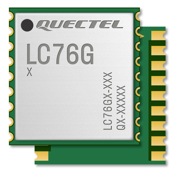
Image: Quectel GNSS Module
Designed for battery-operated, ultra-low power GNSS devicesThe LC76G module is a compact, single-band, ultra-low power GNSS module that features fast and accurate location performance. The module can concurrently receive and process signals from the GPS, GLONASS, BeiDou, Galileo and QZSS constellations. The LC76G has an internal surface acoustic wave filter and integrated low-noise amplifier, which can be connected directly to a passive patch antenna and provides filtering against unwanted interference. With a compact size of 10.1 mm × 9.7 mm × 2.4 mm, the footprint of the LC76G is compatible with other industry solutions, as well as Quectel’s legacy L76 and L76-LB modules. The LC67G is designed for battery-operated, ultra-low power GNSS devices, such as wearable personal trackers, wildlife and livestock tracking, toll tags, portable container trackers, as well as several traditional markets such as shared mobility and low-cost asset trackers.
Quectel Wireless Solutions, quectel.com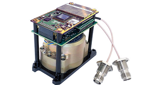
The INS-DH-OEM. (Photo: Inertial Labs) Inertial Navigation System
Incorporates NovAtel and Honeywell technologyThe INS-DH-OEM utilizes a dual-antenna NovAtel GNSS receiver and a Honeywell HG4930-CA51 inertial measurement unit (IMU). The INS-DH-OEM contains Inertial Labs’ on-board sensor-fusion filter, navigation and guidance algorithms, and calibration software. The INS-DH-OEM has three axes, a full operational temperature range, advanced MEMS accelerometers and new-generation tactical-grade MEMS gyroscopes to provide accurate position, velocity, heading, pitch and roll. It is small and lightweight, measuring 85.5 mm x 67.5 mm x 52.0 mm and weighing 280 g. The dual-antenna NovAtel GNSS receiver is operational with GPS, GLONASS, Galileo, BeiDou and QZSS constellations. The INS-DH-OEM is compatible with most commercially available lidars including Velodyne, Riegl and Faro. The algorithms are suitable for different dynamic motions of vessels, ships, helicopters, UAVs, gimbals and land vehicles.
Inertial Labs, inertiallabs.com
Image: MSO Speed Sensor
Multi-use sensor for workflowThe Speed Wedge MKII is a true-ground speed sensor and active motion detector for moving objects, based on radar doppler technology. This sensor is suitable for use in indoor and off-highway vehicles, conveyor belts, material flow and open channel water surface flow. The sensor contains a dead-reckoning system component for inertial measurement units and integrated management systems (IMS) in GPS/GNSS-denied environments such as in tunnels and underground mining operations. It also features sensor fusion with GNSS and IMS improving positioning accuracy, quality and reliability. Speed Wedge MKII deploys a radar front-end with planar antennas continuously emitting electro-magnetic waves at 24 GHz. It is designed for contactless measurement of speed and distance travelled independent on wheel/drive slip. For demanding applications Speed Wedge MKII is sealed and potted in a rugged encasing. Speed Wedge MKII is available in variants with pulse, serial RS232 and CAN-Bus output. High-speed up to 200 km/h is available.
MSO, mso-technik.de/home-en.html
Image: Orolia GNSS Simulations Software
For simulation and testing needsSkydel GNSS simulation software can now generate more than 500 simulated satellite signals. This platform is suitable for GNSS users, experts and manufacturers, as well as users needing a low-Earth-orbit-capable simulation system. Skydel contains a feature that includes multi-constellation and multi-frequency signal generation, remote control from user-defined scripts, and integrated interference generation. In addition to generating a high channel and satellite count, Skydel also can produce navigation warfare signals without any additional hardware.
Orolia, orolia.com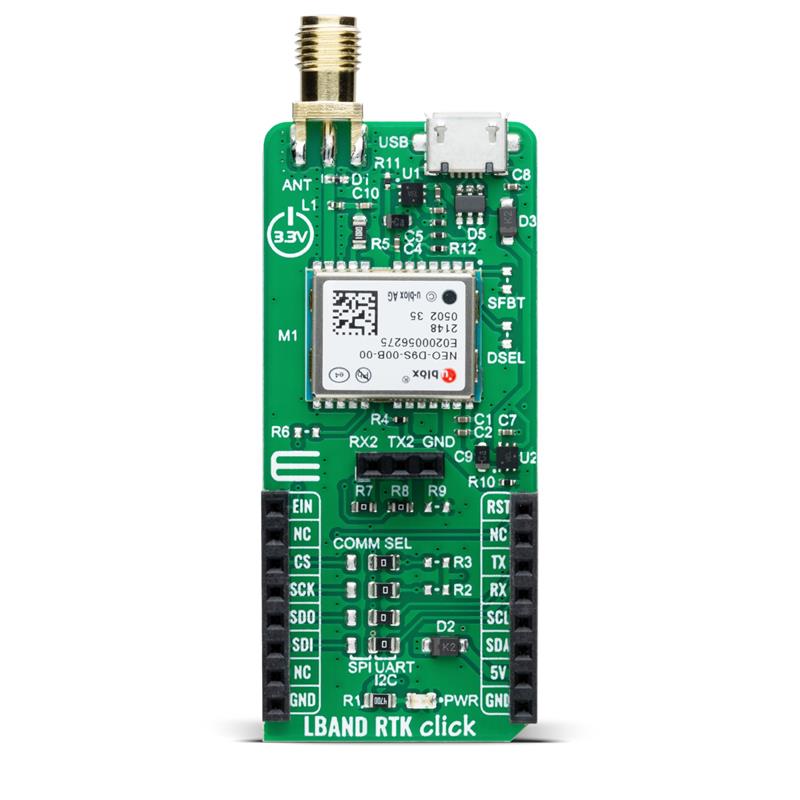
Image: Mikroe Compact Add-On Board
Provides access to L-band GNSS correctionsLBand RTK Click is a compact add-on featuring the NEO-D9S-00B, a professional-grade, satellite data receiver for L-band corrections from u-blox. Operating in a frequency range from 1,525 MHz to 1,559 MHz, the NEO-D9S-00B decodes the satellite transmission and outputs a correction stream. This enables a high-precision GNSS receiver to reach accuracies down to centimeter-level. An independent stream of correction data, delivered over L-band signals, ensures high availability of position output. LBand RTK Click also uses several mikroBUS pins. In addition, LBand RTK Click contains an SMA antenna for connecting a Mikroe-brand antenna. This antenna easily allows positioning in space, supporting GNSS L-band frequencies. LBand RTK Click implements advanced security features such as signature and anti-jamming mechanisms. It also can be integrated with other GNSS receivers from the u-blox F9 platform.
Mikroe, mikroe.com -
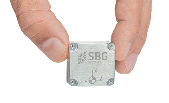
SBG Systems launches Quanta Micro INS
Photo: SBG Systems SBG Systems has announced a new inertial navigation system (INS) named Quanta Micro, completing its Quanta product line.
The Quanta Micro GNSS-aided INS offers a unique combination of navigation performance and low size, weight, power and cost (SWAP-C).
Quanta Micro leverages a survey-grade inertial measurement unit (IMU) for optimal heading performance in single antenna applications, and high immunity to vibrating environments. An optional secondary antenna enables fast heading initialization in low dynamic applications.
Main Features
- Accuracy: 0.015° roll/pitch, 0.035° heading, 1 cm position (PPK)
- Integrates a survey-grade IMU: 0.8°/h gyro bias instability
- Versatile INS/GNSS to suit land, air or marine applications
- Highly tested and calibrated from -40°C to 85°C
- Robust to vibrating environments
- Quad-constellation multi-band RTK GNSS receiver
- Smooth post-processing workflow with Qinertia software
- Major size reduction with no compromise on performance.
-
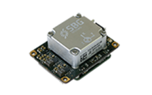
SBG Systems introduces its first tactical-grade IMU
SBG Systems is introducing the Pulse-40 inertial measurement unit (IMU), a tactical-grade IMU designed for high performance in harsh conditions, but miniaturized for applications where precision and robustness matter in all conditions.
Use cases include warfare systems, satellite communications, robotics, lidar devices, gimbals, cameras and inertial navigation systems (INS).
The Pulse-40 IMU provides six-degrees-of-freedom. It integrates micro-electromechanical (MEMS) three-axes accelerometers and gyroscopes in a unique redundant design that allows the device size to shrink while pushing performance to its maximum.
The Pulse-40 on a development board. (Photo: SBG Systems) Among the performance specifications, the Pulse-40 features excellent gyro and accelerometer bias instability of 0.8°/h and 6 µg respectively, enabling long dead-reckoning and maintaining excellent heading performance. With sensors featuring extremely low vibration rectification error (VRE), the Pulse-40 is able to sustain high vibration environments, up to 10 g root-mean-squared.
An embedded continuous built-in-test ensures data reliability during operation, a key parameter for critical applications. The Pulse-40 requires no periodic maintenance. An intensive qualification process — including accelerated aging — guarantees that the sensor behavior is stable over time.
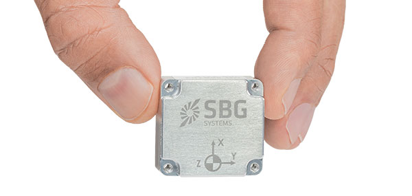
Photo: SBG Systems Main Features
- Size, weight and power (SWaP) design: 12 grams, 0.3W Power consumption
- Ultra-low noise gyro (0.08°/√h) and excellent gyro bias instability (0.8°/h)
- High-precision accelerometers (6 µg)
- Low vibration rectification error: shocks and vibrations MIL-STD 810 qualified
- High bandwidth (480Hz) and high data rate (2KHz)
- Highly tested and calibrated from –40° C to 85° C
- No export restrictions
Research Result
SBG Systems’ sensor calibration and validation tools, initially based on a single axis motion simulator with a temperature chamber, have evolved over the years and are now based on 100% automated, multi-axis motion simulators with temperature chambers. The high level of automation mitigates human-error risk and ensures that all the delivered products meet their specifications. Its INS are the result of extensive research in signal processing, micro-electronics, calibration algorithms and sensor qualification, the company said.
With very low gyro noise and bias instability, the navigation performance is maximized in GNSS-disturbed or -denied environments. The Pulse-40 is export license free and ITAR free.