China’s BeiDou navigation industry in 2025 achieved a total output value of 1.33 trillion yuan (US$195 billion), according to a report released Monday by the GNSS and Location Based Services (LBS) Association of China, or GLAC, reports CGTN.
The BeiDou industry includes remote sensing and geographic information systems (GIS), mobile communications and indoor positioning. The satellite navigation sector generated 629 billion yuan (US$92 billion) in 2025, up 9.24% year on year, according to the report.
China has established a complete BeiDou industrial chain and supply chain, covering chips, modules, antennas, terminals, system integration and application services, , according to the report. Domestic capabilities are becoming increasingly self-reliant, with the cumulative shipments of BeiDou-compatible chips and modules reaching hundreds of millions, supporting a secure and robust industry supply chain.
Domestic sales of BeiDou-enabled terminals exceeded 410 million units in 2025, with more than 2.2 billion BeiDou-capable devices in use across the country.
Internationally, BeiDou services and related products have been exported to more than 140 countries and regions.
The market for mid- and high-precision GPS receivers is set to experience significant expansion in the coming years. Driven by evolving technologies and growing applications across various sectors, this market is attracting substantial attention, according to The Business Research Company.
The market size for mid- and high-level precision GPS receivers is expected to reach $6.85 billion by 2030, expanding at a compound annual growth rate (CAGR) of 12.2%. This robust growth over the forecast period is fueled by advancements in autonomous vehicle systems, expanding smart infrastructure projects, the rise of precision agriculture, increased use of highly accurate mapping solutions, and wider adoption of sophisticated GNSS correction services.
Important trends shaping the market include the pursuit of centimeter-level positioning accuracy, the integration of RTK and PPK technologies, use of multi-frequency signal processing, compatibility with survey software, and enhanced GNSS mapping precision.
The market features numerous influential companies, including Stonex Group Inc., Raytheon Technologies Corporation, Hexagon AB, Trimble Inc., Topcon Positioning Systems Inc., u-blox AG, Hi-Target Surveying Instrument Co. Ltd., CHC Navigation Technology Ltd., Carlson Systems Holdings Inc., Septentrio N.V., Hemisphere GNSS Inc., Javad GNSS Inc., Swift Navigation Inc., Thales Group, Geneq Inc., South Surveying & Mapping Technology Co. Ltd., Tersus GNSS Inc., Eos Positioning Systems Inc., NavtechGPS Inc., Satlab Geosolutions AB, Tallysman Wireless Inc., Leica Geosystems AG, NovAtel Inc., Spectra Precision, Unistrong Science & Technology Co. Ltd., and ComNav Technology Ltd.
Notably, in March 2023, Netherlands-based CNH Industrial N.V., a provider of agricultural and construction equipment as well as precision automation solutions, acquired Hemisphere GNSS for $175 million. This strategic move aims to combine Hemisphere’s high-precision GNSS receivers and satellite-based correction technologies with CNH’s capabilities to enhance machine control, autonomy, and positioning in both construction and agricultural sectors. Hemisphere GNSS, headquartered in the U.S., supplies advanced GNSS receivers, antennas, and correction services tailored for surveying, machine control, agriculture, and marine uses.
Top companies in this sector are actively launching new products to maintain competitive advantage.
For example, in October 2025, Unicore Communications Inc., a China-based GNSS technology provider, introduced the UM98XC Series-a next-generation, all-constellation, multi-frequency RTK GNSS module. Supporting GPS, BDS, Galileo, GLONASS, and QZSS systems along with L-Band and CLAS correction services, the UM98XC offers centimeter-level positioning accuracy. It also features advanced anti-jamming capabilities, energy-efficient design, and consistent performance in challenging environments, making it well-suited for autonomous driving, precision agriculture, unmanned aerial vehicles, and smart transportation sectors.
This launch underscores Unicore’s commitment to pushing the boundaries of GNSS precision, reliability, and scalability for industrial and automotive applications.
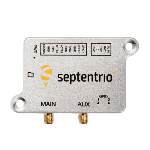
Septentrio, part of Hexagon, has launched the mosaic-G5 P6 multi-frequency precise positioning module. The receiver, measuring 23 mm by 16 mm and weighing 2.2 grams, enables reliable positioning without performance compromises for commercial UAVs, robots and other size and power-constrained applications.
AIM+ Premium technology protects the receiver from sophisticated intentional or unintentional GNSS jamming or malicious spoofing attacks.
“By extending the mosaic family with mosaic-G5 P6, we are bringing an all-in-one module offering accuracy, resilience, and flexibility for demanding industrial applications,” said Yasmine Hunter, product manager at Septentrio.
The newly released module offers one of the highest update rates on the market, combined with low latency, essential for efficient and accurate control systems and navigation. In addition to high-accuracy positioning, raw measurements are also available for high-performance sensor fusion.
The mosaic-G5 P6 also offers users the flexibility to balance accuracy and availability and is compatible with Galileo High Accuracy Service (HAS) for decimeter-level positioning out of the box. Users can choose single- or dual-antenna configuration for accurate GNSS heading enabling robust orientation and motion control in industrial automation applications such as autonomous machinery, robotics and precision guidance systems.
The new module is compatible with widely used, open-source autopilots like PX4 and ArduPilot as well as ROS, simplifying integration into robotic and drone systems. Its evaluation kitsimplifies testing with direct autopilot connections, while the free RxTools user interface assists with the setup and evaluation process.
Meet our GNSS experts and see mosaic-G5 P6 during Xponential in Detroit, Michigan, May 11–14, at booth #37030. For more information about mosaic-G5 P6 or other Septentrio products, contact the Septentrio team.
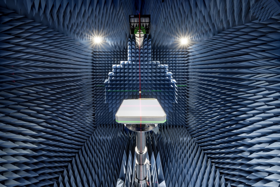
A joint measurement trial, Rohde & Schwarz and Greenerwave have demonstrated that a near-field system can record a full radiation pattern of a 50 cm Ku band electronically steerable array for a SATCOM antenna in a half hour.
The achieved results match simulation models within a decibel, making this approach a fast and reliable way to verify antenna performance.
For manufacturers of SATCOM systems facing large chamber constraints, it offers a clear path to quicker, more cost-effective testing.
Electronically steerable array (ESA) antennas are becoming key components in modern SATCOM systems. Accurate knowledge of their radiation pattern is required for reliable operation in LEO, MEO and GEO orbits. However, conventional far‑field testing demands chambers that are often larger than practical for Ku or Ka band antennas, especially when the aperture of the Antenna Under Test (AUT) reaches half a meter or more.
Compact Antenna Test Ranges (CATR), on the other hand, are still relatively large for these AUTs and require time-consuming dual-axis positioning of AUT to map the radiation pattern.
Rohde & Schwarz and Greenerwave have reached a breakthrough in ESA antenna testing in a joint measurement trial, achieving highly accurate radiation pattern characterization in the near field, significantly reducing measurement time. Greenerwave’s innovative SATCOM user terminals are based on reconfigurable intelligent surfaces (RIS), allowing the company to design electronically steerable antennas that deliver high-performance connectivity while reducing energy consumption and reliance on semiconductors compared with conventional solutions.
For the joint measurement campaign, Rohde & Schwarz provided its R&S TS8991 over‑the‑air and antenna measurement system, equipped with a conical cut positioner, and its R&S ZNA vector network analyzer. Together, they evaluated Greenerwave’s passive single‑aperture ESA that uses RIS technology for beamforming. The antenna under test (AUT) features a 50 x 50 cm aperture and is designed for low power consumption and easy integration.
The measurement covered an extended upper hemisphere down to a polar angle of 120 degrees, using a one-degree step size. Ten Ku band frequencies were recorded in a total of 32 minutes, thanks to the system’s hardware trigger function. Data was processed using the R&S AMS32 antenna measurement software, which applied a FIAFTA near-field-to-far-field transformation algorithm.
Comparison with the original simulation based on a numerical twin model and with results from Greenerwave’s CATR setup showed peak gain or directivity variations of max. 1 dB and typically 0.3 dB, validating the accuracy of the near-field solution. Export options allow users to continue analysis in tools such as CST Microwave Studio or MATLAB.
The trial shows that even large SATCOM antennas can be characterized quickly and accurately with the R&S TS8991 antenna test system from Rohde & Schwarz in a near-field setup, providing a practical alternative to large-sized far-field chambers or CATRs.
According to Rohde & Schwarz, the system setup can be used by other SATCOM makers testing broadband, IoT or back haul antennas for applications requiring flexible beam control and high data rates. The setup can be integrated more easily into research lab environments, and it shortens test cycles, reducing overall development cost.
Visual localization is widely used as a low-cost solution for autonomous driving, robotics, and mobile navigation. However, monocular systems remain vulnerable to illumination changes, weak texture, occlusion, motion blur and long-term drift.
Existing map-based methods can reduce that drift by aligning camera observations with a prebuilt global map, yet many still struggle with redundant computation, weak cross-modal matching between camera images and point clouds, and optimization errors in large-scale or repetitive scenes.
The challenge is especially important for lightweight platforms that cannot afford onboard lidar, inertial measurement unit (IMU) and heavy computing. Because of these problems, deeper research is needed on camera-only map-based localization that can stay accurate, efficient and stable in complex real-world environments.
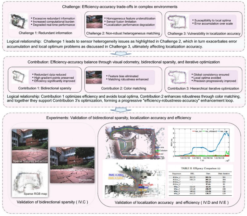
Overview of the proposed camera-only map-based localization framework. (Credit: Satellite Navigation)
On April 20, researchers from Wuhan University and Chongqing University reported (DOI: 10.1186/s43020-026-00196-x) in Satellite Navigation a camera-only localization framework that uses prebuilt colored point cloud maps, a dual-sparsity matching strategy that retains high-gradient features in both the map and image observations, and hierarchical geometric–photometric optimization to improve both positioning accuracy and computational efficiency in GNSS-challenged environments.
The system is built around two connected stages. First, the researchers generate a sparse colored point-cloud map from a denser map produced by lidar–IMU–camera mapping, keeping only high-gradient points that preserve visually salient structures while removing weak or redundant information.
They apply a similar sparse selection process to online camera images, creating what the team calls “dual-sparsity matching” between map and observation. During localization, the method uses Lucas–Kanade optical flow to track sparse 2D image features and associates them with 3D map points, while hidden-point removal helps retain only the map points actually visible from the current viewpoint.
The pose is then refined through an iterated error-state Kalman filter in two stages: a geometric PnP-style correction for stable coarse alignment, followed by photometric refinement using image intensity consistency for sub-pixel accuracy.
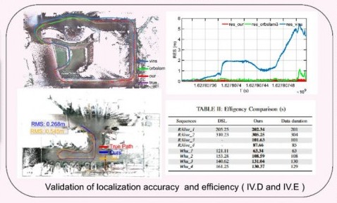
Tests on the R3live and WHU-Motion datasets showed major gains over existing methods. Compared with direct sparse localization (DSL), the new approach cut absolute trajectory error (ATE) by 52% to 95% across challenging sequences, including a drop from 1.883 m to 0.152 m on R3live_5. It also improved accuracy by up to 76.6% over I2D-Loc++, reduced total processing time by as much as 47.7%, and remained robust in degenerate scenes where geometry-only localization deteriorated to 9.23 m while the proposed tracker held an ATE of 0.076 m.
Ablation results further showed that colored maps, bidirectional sparsity, and hierarchical optimization each played a distinct role in achieving the final balance of speed, robustness, and precision.
The authors said the main advance is not simply adding color to a map, but treating the global colored point cloud map as a continuous observation within the visual odometry framework. They said the framework shows that a monocular camera can localize far more robustly when paired with a prebuilt colored point cloud map and a coarse-to-fine optimization design that avoids poor local solutions.
In their view, the study offers a practical middle ground between fully sensor-rich systems and fragile vision-only pipelines, preserving much of the accuracy benefit of map-based localization without demanding equally heavy hardware on the client platform.
The work could have immediate value for indoor logistics robots, underground inspection platforms, warehouse vehicles, parking-garage navigation systems, and other low-cost autonomous agents operating where GNSS is weak or unavailable. Because the mapping can be completed offline and reused, the online platform needs only a monocular camera, which lowers sensing requirements while retaining strong global constraints.
That makes the method especially attractive for scalable deployments in structured but challenging spaces such as tunnels, campuses, hospitals, and industrial facilities. More broadly, the study suggests that future navigation systems may become both lighter and more dependable by making better use of the information already shared between maps and images, rather than relying only on ever-larger sensor stacks.
CHC Navigation (CHCNAV) has released the AlphaAir 6, a flagship airborne lidar system designed for UAV-based laser scanning, drone lidar mapping, and aerial surveying in high-relief and complex terrain.
Combining prism scanning technology with a high-grade inertial navigation system (INS), the AlphaAir 6 delivers a maximum ranging capability of up to 2,100 meters and supports efficient data capture at typical flight altitudes of 400 to 600 meters above ground level.
The AlphaAir 6 integrates an upgraded laser engine and a high-grade IMU with 0.3°/h bias stability to improve trajectory accuracy and point cloud quality. This design removes the need for pre-mission IMU calibration and supports stable, efficient data collection for topographic mapping, corridor mapping, and wide-area aerial survey workflows.
The AlphaAir 6 combines fifth-generation real-time waveform processing with advanced multi-period technology to capture richer, denser, and more precise lidar data across complex terrain, vegetation, and built environments. According to CHCNAV, even at an ultra-high pulse repetition rate of 2,000,000 pulses per second, it continues to support real-time point cloud output, giving operators immediate in-flight visibility and a faster path to survey-grade 3D results.
To meet different project requirements, the AlphaAir 6 is available in single-camera and dual-camera configurations. Both options use large-format CMOS sensors to deliver high-resolution imagery, while the dual-camera version adds an ultra-wide field of view to improve image coverage and increase mapping efficiency.
With an integrated design and a weight of 1.35 kg, the AlphaAir 6 reduces payload burden on UAV platforms and helps extend flight endurance. Open interface protocols support integration with mainstream multirotor and fixed-wing UAVs, giving surveying and mapping professionals more flexibility across different mission types.
Thales has launched the TopStar Smart Receiver, a three-in-one ultra-compact solution designed to provide land forces with resilient positioning, navigation and timing capabilities, while maintaining radio communications in increasingly contested electronic warfare environments.
The TopStar Smart Receiver can be integrated into land vehicles, drones and munitions.
Key features
Dual-constellation GNSS receiver. The receiver integrates signals from military constellations, Galileo PRS and civilian GPS, and provides resistance to spoofing with enhanced accuracy and availability.
Anti-jamming function. Its adaptive controlled radiation pattern antenna (CRPA) reduces interference from jammers, and enables operation at distances up to 30 times closer than with a conventional GPS receiver.
High-performance clock. The clock ensures synchronization of tactical radios for up to 48 hours following GNSS signal loss, versus 30 minutes with conventional equipment.
Produced entirely within a sovereign European industrial base, the TopStar Smart Receiver is assembled at Thales’ site in Valence, France. The receiver is now available for testing in real-world conditions.
“Powered by cutting-edge technologies, the TopStar Smart Receiver delivers resilient, high-performance PNT capabilities for land platforms, drones and munitions,” said Florent Chauvancy, vice president of avionics and flight activities, Thales. “Innovative, reliable, competitive and compact, it ensures mission continuity in the most demanding operations, showcasing Thales’ expertise and commitment to innovation in support of the armed forces.”
Taoglas will showcase its latest antenna technologies at the 2026 European Conference on Antennas and Propagation (EuCAP) in Dublin, Ireland, taking place April 19-24, in the Dublin convention center. Taoglas will display at Stand 52.
At this year’s exhibition and conference, Taoglas will underline the increasing complexity of antenna integration in electronic systems, where performance depends on interactions between the antenna, PCB, enclosure and multi‑radio environment.
The company also will host a “GNSS Evolution Masterclass: Bridging Theory and Field Performance” on April 21, 15:50-17:30. The session will cover the evolution from single‑band to multi‑band GNSS and provide practical guidance on antenna characteristics, performance metrics, correction services and evaluation methods for real‑world positioning performance.
At its booth, Taoglas will highlight its AI-driven Antenna Product Recommendation Engine, designed to help users identify antenna options based on needs. It complements Taoglas’ existing design and configuration tools, including the Antenna Integrator for PCB placement, which adds new features and antenna models frequently, enabling a seamless path from initial selection through to integration.
In the technical conference programme, Taoglas will also present new antenna design work, including a poster on innovations in tri‑band Wi‑Fi antenna integration and a paper on compact antennas for LPWA and IoT devices.
“EuCAP is a unique opportunity to connect cutting‑edge research with real‑world engineering challenges,” said Dermot O’Shea, co‑founder and CEO of Taoglas. “With Taoglas’ roots in Ireland, it is especially rewarding to highlight local RF and antenna expertise while engaging with the global engineering community.”
Taoglas is supporting EuCAP 2026 as a gold sponsor. Visitors can meet the Taoglas team at the event or visit www.taoglas.com for more information.
During a recent infrastructure survey, a handheld scanning system captured a multi-acre property in less than 15 minutes. As the operator moved through the site, the device continuously scanned the environment while maintaining centimeter-level positioning using satellite signals, inertial sensors and lidar.
The result was a fully georeferenced three-dimensional dataset containing terrain, buildings, trees and infrastructure — captured in a fraction of the time required by traditional survey workflows. Technologies such as these illustrate how far positioning systems have evolved. What once required multiple instruments, control networks and extended field observation can now be accomplished through integrated sensing systems combining satellite navigation with reality capture.
Yet, the foundation of these capabilities traces back more than six decades. Today, billions of devices depend on GNSS positioning. Smartphones, vehicles, aircraft, agricultural equipment and industrial systems rely on satellite signals to determine location and synchronize time. Within the geospatial industry, GNSS has evolved beyond navigation. It now serves as the spatial framework anchoring a growing ecosystem of sensors and measurement technologies capable of capturing the physical world in extraordinary detail.
Receiver evolution and productivity
While satellite constellations and positioning algorithms have steadily improved, many of the most noticeable changes for surveyors have occurred in the instruments themselves.
Modern GNSS receivers are smaller and more efficient than earlier generations. Advances in electronics, antenna design, signal processing and battery technology have reduced size and power requirements while improving reliability and usability in the field.
According to Chris Pappas, owner of Green Forest Surveys and a geospatial thought leader, recent GNSS receiver development has focused on usability rather than increases in raw positioning accuracy.
“What I’ve seen lately is smaller receivers, longer battery life and smaller antenna sizes on the heads,” Pappas said. “The quality has basically remained the same.” These improvements may appear incremental, but they have meaningful impacts on field operations.
Survey crews work in demanding environments such as steep terrain, construction sites, transportation corridors and remote infrastructure locations where equipment weight and power management affect productivity.
“It’s portability. It’s fatigue from walking up a hill,” Pappas explained. “And the= longer battery life means you don’t have to constantly swap batteries or carry extras. You can take a single set with you and it’ll last all day.”
Modern receivers also have benefited from advancements in satellite signals and correction services. Today’s survey-grade receivers routinely track multiple frequencies from multiple constellations.
Miniaturization is not simply a reduction in size. Achieving multi-constellation tracking, multi-frequency processing and real-time correction required major advances in RF engineering and integrated circuit design.
Capabilities that once required large, power-intensive hardware platforms are now integrated into compact receivers capable of operating an entire day on a single charge.
Signal modernization, algorithms and the RTK engine
While receiver hardware has become smaller and more power-efficient, some of the most significant advancements in GNSS performance have occurred in the algorithms and processing engines operating inside those devices.
Modern receivers are specialized computing platforms designed to process signals from multiple constellations, frequencies and correction sources simultaneously. Tracking multiple constellations enables receivers to observe dozens of satellites while reducing ionospheric and multipath errors.
The real breakthrough, however, has come from improvements in the RTK engine itself.
RTK positioning relies on resolving the carrier-phase ambiguities — the unknown integer number of wavelengths between the satellite and the receiver. Earlier RTK systems often required extended initialization periods.
Modern receivers use more sophisticated ambiguity resolution algorithms that leverage multi-frequency observations and improved statistical modeling. Initialization times have dropped, and solutions are more robust in difficult environments.
Modern RTK engines incorporate advanced filtering techniques, stochastic modeling and automated outlier detection to maintain stable solutions when individual observations become unreliable.
These improvements are particularly important as surveyors increasingly work in environments where GNSS conditions are less than ideal. Urban infrastructure, tree canopy and industrial facilities can obstruct satellite signals and introduce multipath errors.
Advanced filtering architectures allow receivers to reject corrupted observations while maintaining stable positioning using valid measurements.
Many modern receivers incorporate Kalman filtering frameworks that continuously estimate position, velocity, clock bias and measurement uncertainties.
These filters allow GNSS measurements to be integrated with inertial sensors and motion constraints, creating more stable positioning solutions.
Network-based correction services also have become increasingly common. Rather than relying solely on a nearby base station, many surveyors now use network RTK systems that aggregate observations from multiple reference stations across a region.
These networks model atmospheric errors and deliver corrections through cellular or internet connections.
Precise point positioning (PPP) techniques, which use precise orbit and clock information rather than local base stations, also have matured significantly. Modern PPP engines can now resolve centimeter level positioning in real time or near real time, something that only a few years ago could take up to an hour using satellite based augmentation.
These advances have been enabled by the evolution of GNSS chipsets. Modern receivers integrate RF front ends, signal processors and navigation engines into compact system-on-chip architectures capable of tracking dozens of signals while running complex positioning algorithms in real time.
The result is a positioning engine that is no longer confined to a single receiver mounted on a survey pole, but operates as the central reference system for a network of sensors capturing complex environments.
The maturity of the modern positioning engine
One of the less visible but most important developments in GNSS over the past decade is the maturation of the positioning engine itself. Early GNSS receivers were essentially signal trackers paired with simple navigation algorithms. Today’s receivers function more like specialized computing platforms optimized for real time estimation.
At the core of these systems is an estimation framework that continuously evaluates the quality of each observation entering the solution. Carrier phase measurements provide the highest precision available from GNSS, but are highly sensitive to noise, multipath and signal interruptions.
Modern RTK engines must balance precision with reliability. Rather than assuming every observation is equally valid, processing engines assign dynamic weights based on signal strength, satellite geometry, atmospheric models and measurement stability. These approaches allow receivers to maintain accurate positioning even when portions of the satellite environment become unreliable.
Solar storms, such as this one in North Carolina, produce beautiful auroras. They also cause signal disruption and interference for GNSS systems. Many of the modern RTK engines now have the ability to filter out this interference and maintain a fix.
The introduction of multi frequency signals also has changed how ambiguity resolution is performed. Earlier RTK systems relied on dual-frequency measurements to estimate ionospheric delay and resolve integer ambiguities. With additional frequencies across multiple constellations, modern receivers apply more advanced ambiguity resolution strategies that improve convergence speed. In practical terms, this means surveyors spend less time waiting for initialization and more time collecting data.
Modern receivers also incorporate tightly integrated filtering architectures. Extended Kalman filtering frameworks continuously estimate position, velocity, clock bias, atmospheric parameters and measurement noise. These models treat positioning as a dynamic estimation problem rather than a static calculation performed at each epoch. The result is a positioning engine capable of maintaining stable centimeter level solutions even when signal conditions fluctuate. For surveyors working in environments with partial satellite obstruction, intermittent multipath or complex site conditions, these improvements often determine whether a day in the field is productive or not.
GNSS as foundational infrastructure
Today, GNSS occupies a unique position in the technology landscape. It is both a mature infrastructure system and a platform for continued innovation. The fundamental architecture of satellite navigation has remained largely consistent for decades, while the ecosystem built around those signals has expanded dramatically.
In many ways, GNSS has become invisible because it works so well. Surveyors, engineers and geospatial professionals interact with receivers, correction services and data products rather than with the satellites themselves. Positioning is expected to function, much like electricity or cellular connectivity. But under that routine operation lies one of the most sophisticated global infrastructure systems ever constructed.
At the space segment level, multiple international constellations provide overlapping coverage. The United States’ GPS, Russia’s GLONASS, Europe’s Galileo and China’s BeiDou systems transmit modernized signals designed to improve accuracy, reliability and interoperability. Regional systems such as Japan’s QZSS and India’s NavIC further strengthen coverage.
This multi-constellation environment represents one of the most significant changes in the GNSS landscape throughout the past two decades. Early survey grade receivers relied primarily on GPS signals, while modern receivers track four or more global constellations simultaneously.
The impact extends beyond redundancy. Observing more satellites improves geometric strength and allows receivers to maintain robust solutions in environments where single constellation systems would struggle, including urban corridors, forested areas and complex infrastructure sites.
Signal modernization has expanded the range of measurements available to positioning engines. Additional civilian frequencies such as GPS L5 and Galileo E5 allow better modeling of ionospheric effects and reduced measurement noise, contributing to more stable positioning solutions.
The most important shift, however, is not in the satellites themselves, but in GNSS’s role within the broader measurement ecosystem.
In the surveying and geospatial industries, GNSS has evolved from a standalone measurement technique into the spatial reference framework for modern data capture technologies. It now anchors measurement platforms capable of capturing millions of spatial observations.
In traditional surveying, GNSS remains a primary method for establishing control networks and geodetic reference points, with RTK and post-processed kinematic techniques routinely achieving centimeter-level accuracy.
In construction and machine control, GNSS enables automated positioning systems that guide heavy equipment using digital terrain models in real time.
In agriculture, precision farming systems use satellite positioning to guide equipment along exact paths, reducing fuel consumption and optimizing inputs.
GNSS also functions as the primary time synchronization system for critical infrastructure, including telecommunications, financial systems and power grids.
For geospatial professionals, the most significant change is how GNSS interacts with emerging measurement technologies. Rather than acting as a standalone sensor, it now operates as the global reference frame for integrated systems.
The satellite-derived position establishes a coordinate foundation that other sensors use to build dense spatial models. In a typical workflow, GNSS establishes the reference, inertial sensors track motion, lidar captures geometry and cameras record imagery. All observations rely on the GNSS reference frame to maintain spatial consistency.
This enables a shift from discrete point measurement to continuous data capture. Instead of collecting individual points, modern platforms capture millions of observations that can be analyzed and extracted as needed.
GNSS remains the backbone of this process. Even as new sensors emerge, the requirement for a stable global reference frame has not changed. GNSS provides that anchor.
Sensor fusion and the expanding positioning stack
While GNSS technology continues to evolve, some of the most significant advances in positioning are occurring through integration with other sensing technologies.
Trees, such as this 150-year-old tulip poplar, were killers of previous-generation GNSS systems. Robust designs, the modern sensor stack, and powerful algorithms can now fix reliably in heavy canopy, saving hours of traditional work.
Modern positioning systems operate as part of a broader sensor ecosystem. Satellite observations provide the global reference frame, while inertial measurement units track motion and orientation, lidar sensors capture geometry and visual sensors analyze environmental features.
Hybrid platforms extend GNSS capability into environments where satellite signals alone may struggle. Several manufacturers now offer handheld systems that combine GNSS receivers with lidar scanning and inertial navigation. Systems such as the CHC Navigation VLi100 integrate GNSS, lidar, inertial sensing and visual positioning into a single instrument. The VLi100 also incorporates the SureFix 2.0 engine, which uses lidar to stabilize the GNSS position for up to 60 ft after signal loss, extending positioning capability in obstructed environments.
The Tersus S1 SLAM system similarly combines lidar-based mapping with GNSS positioning to capture dense spatial data in complex environments.
The same principles drive mobile mapping systems designed for infrastructure-scale data capture. Trimble’s MX series, including the MX9 and MX90, combines GNSS positioning, high-accuracy inertial navigation and high-density lidar to capture detailed spatial data while in motion.
“Sensor fusion is probably the biggest one right now,” said Justin Brooks, sales manager for reality capture at Trimble. “When you combine GNSS with lidar and inertial sensors, you’re not just collecting points anymore. You’re capturing entire environments.”
Mobile mapping is increasingly used across the energy sector. According to Jason Rosbach, director, energy solutions at Trimble, large renewable energy projects such as utility scale solar and wind developments require rapid spatial documentation across thousands of acres. These systems allow survey teams to capture dense geospatial datasets while maintaining consistent positioning through tightly integrated GNSS and inertial navigation.
Karl Bradshaw, director, product management, reality capture at Trimble, explained that GNSS remains the core reference.
“In the MX systems, that GNSS position is the initial core point,” Bradshaw said. “Then the IMU interpolates the vehicle path between those GNSS fixes and provides heading, pitch and roll orientation. Every lidar pulse gets geolocated using that combined solution.”
Reality capture and the GNSS positioning pyramid
The convergence of GNSS positioning with lidar scanning, inertial navigation, and SLAM-based mapping is driving the broader adoption of reality capture workflows across the geospatial and infrastructure industries.
At the core of these systems remains a GNSS-centric positioning pyramid. Satellite observations provide the spatial reference that anchors all other measurements. The additional sensors extend and stabilize that position when conditions become challenging.
From point measurement to spatial data acquisition
The integration of GNSS with modern sensing technologies has changed the scale of spatial data collection.
For most of the 20th century, surveying workflows were based on discrete point measurements. Whether using optical instruments, total stations or early GNSS receivers, surveyors collected individual observations that were later combined to construct maps and models.
This approach remains essential for control networks and boundary surveys, but many modern applications now operate at a fundamentally different level of data density.
Lidar scanners, mobile mapping systems and handheld SLAM platforms can collect millions of measurements in minutes. Instead of selecting points, operators move through an environment while continuously capturing geometric observations. These datasets provide a far more detailed representation of the physical world.
GNSS enables this transition by providing a stable global reference frame. Without it, large point clouds and reality capture datasets would exist only as isolated local models. GNSS allows these datasets to align with engineering design files, geographic information system (GIS) databases and previous survey measurements.
This spatial consistency makes reality capture practical for large infrastructure projects. Transportation departments can compare roadway conditions over time, utilities can integrate asset models and construction teams can verify progress against design.
In each of these workflows, GNSS provides the coordinate framework that keeps datasets aligned across time, sensors and project stages.
The shift from point measurement to continuous data acquisition is one of the most significant changes in geospatial practice in decades.
Even within these systems, positioning still begins with satellite signals. GNSS remains the foundation. Lidar captures geometry, inertial sensors measure motion and SLAM algorithms track environmental features, all fused with the GNSS position.
These systems collect dense spatial observations continuously, allowing entire corridors, facilities and infrastructure sites to be captured rapidly. Because these datasets are anchored to GNSS positioning, they maintain consistent spatial reference over time.
Looking ahead
Another development drawing increasing attention across the positioning industry is the emergence of low Earth orbit (LEO) satellite constellations as potential complements to traditional GNSS systems.
Unlike GNSS satellites operating at medium-Earth orbit altitudes of roughly 20,000 kilometers, LEO satellites orbit much closer to Earth. This proximity allows their signals to reach receivers with significantly higher signal strength and faster acquisition times.
Because the satellites move rapidly across the sky, they also provide constantly changing geometry that can improve positioning performance in environments where traditional GNSS signals struggle.
A number of research groups and commercial companies are now exploring how LEO constellations might augment existing GNSS infrastructure. Some approaches rely on signals from existing communications constellations, while others involve dedicated navigation payloads designed specifically for positioning.
For surveyors and geospatial professionals, the potential benefit is improved positioning reliability in environments where GNSS signals are degraded. Urban corridors, industrial sites and areas with heavy canopy often limit satellite visibility and introduce multipath interference that complicates carrier-phase measurements.
Additional signals from LEO satellites could provide stronger observations in these environments while also improving the redundancy of positioning solutions.
The integration of LEO signals would not replace GNSS but rather expand the broader positioning ecosystem that already has begun to emerge through sensor fusion.
Modern positioning systems increasingly combine GNSS, inertial navigation, lidar, camera and SLAMbased mapping into tightly integrated sensor stacks. GNSS provides the global reference frame, while the other sensors extend and stabilize the positioning solution when satellite visibility becomes limited.
If LEO navigation signals become widely available, they will likely become another layer within that stack.
The long-term result could be positioning systems capable of maintaining centimeter-level trajectories across environments that would have been extremely difficult for GNSS-only solutions just a decade ago.
For the geospatial industry, this evolution represents a continuation of a trend that began decades ago: positioning systems becoming more robust, more integrated, and increasingly capable of capturing the physical world in unprecedented detail.
Low-Earth-orbit signals add increased signal strength, geometry diversity and robustness to GNSS.
U-blox, a global leader in positioning and short-range communication technologies for automotive, industrial and consumer markets, is exploring how the introduction of low-Earth-orbit (LEO) signals can complement and integrate with existing GNSS to support mass-market positioning solutions.
The announcement comes following the launch of the European Space Agency’s (ESA) first Celeste LEO-PNT demonstration satellites (IOD-1 and IOD-2) on 28 March 2026, marking a key milestone in bringing LEO-based signals into the operational positioning environment and ESA’s first step toward extending satellite navigation into low Earth orbit.
As the positioning ecosystem evolves, LEO-based signals are emerging as a complementary layer to established GNSS. Designed to augment systems such as Galileo, LEO satellites introduce a new building block characterized by lower orbital altitude, increased signal strength, and rapidly changing satellite geometry. GNSS remains the foundation of global positioning, delivering proven coverage and consistency at scale.
This evolution is not only about additional signals, but about how positioning systems behave over time. The dynamic geometry of LEO satellites introduces new system characteristics that influence convergence speed, robustness, and performance in challenging signal conditions.
Under its Navigation Innovation and Support Program (NAVISP) Element 2 (EL2) project, co-funded by ESA, u-blox is conducting a technical assessment of the role of LEO signals in multi-layer positioning architectures. This work forms part of a broader effort to bring LEO-PNT capabilities to mass-market GNSS receivers, combining emerging LEO signals with established GNSS systems.
This includes early integration work on u-blox’s X20 GNSS platform, exploring how different signal types and frequency bands can be optimally incorporated into u-blox’s positioning systems. The scope of work includes:
Observation and characterization of emerging LEO signal transmissions
Analysis of interactions between LEO signals and GNSS measurements
Evaluation of the impact of dynamic satellite geometry on positioning performance
Exploring different system-level approaches for integrating LEO signals into future platforms
“U-blox is committed to advancing positioning technologies through focused research and collaboration,” said Jani Käppi, head of technology positioning at u-blox. “Our work within the ESA NAVISP framework allows us to better understand how emerging signal sources can complement GNSS and contribute to robust and reliable positioning performance.”
U-blox expects to contribute to the development of the new LEO satellite ecosystem with significant innovation in the positioning solution, collaborating with key partners like ESA.
The Celeste initiative
The Celeste mission is ESA’s initiative for LEO-PNT (Low Earth Orbit Positioning Navigation and Timing) and is in its in-orbit demonstration phase. This first phase features a demonstration constellation of 11 satellites that will fly in low Earth orbit to test innovative signals across various frequency bands. Its goal is to advance satellite navigation concepts for resilient positioning and timing services.
The Celeste in-orbit demonstration phase was approved at ESA’s Council at Ministerial Level of 2022. The fleet is being developed through two parallel contracts respectively led by GMV in Spain with OHB in Germany as core partner, and by Thales Alenia France as prime and Thales Alenia Italy as space segment responsible and involving over 50 entities from more than 14 countries.
Celeste was further supported in ESA’s Council at Ministerial Level of 2025 (CM25), towards the implementation of the next phase: the LEO-PNT In-Orbit Preparatory phase.
Celeste also contributes to one of the three core pillars of ESA’s new European Resilience from Space (ERS) initiative, endorsed at CM25. ERS addresses critical security and resilience needs for Member States while laying the groundwork for future European strategic space capabilities.
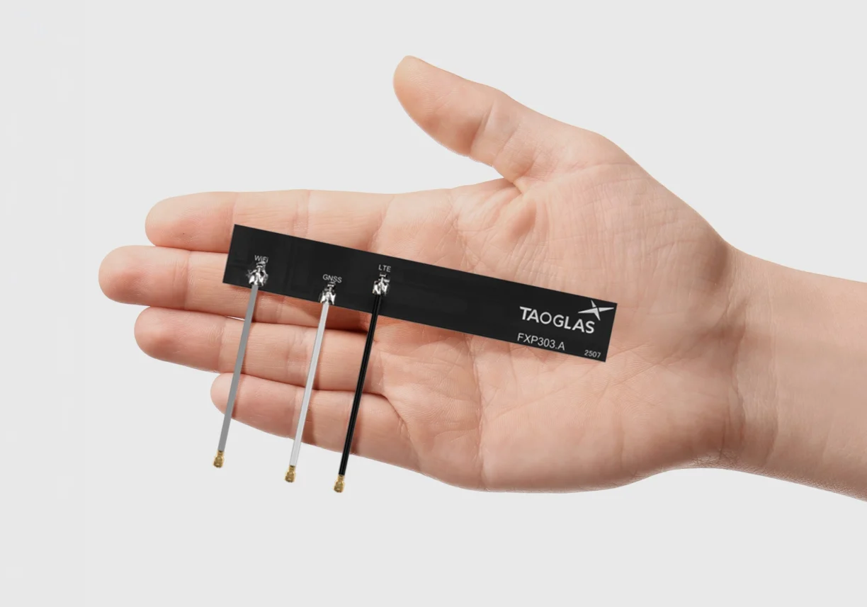
Taoglas is now offering the FXP30x and PC30x series of high-performance embedded combination antennas, a new family of compact antennas designed to support GNSS, cellular and Wi-Fi connectivity for space-constrained electronic devices. Both series enable engineers to integrate multiple wireless technologies within a single antenna, reducing device component count while simplifying device design, speeding up assembly times and accelerating time to market.
The new portfolio includes six antenna models across two form factors: the FXP30x flexible PCB antenna series and the PC30x rigid FR4 PCB antenna series. Both families support cellular frequencies from 600 MHz to 8000 MHz, enabling global connectivity across multiple wireless standards.
The FXP30x series is built on Taoglas’ flexible polymer antenna technology, combining high radiation efficiency, ground-plane independence and ultra-thin construction suitable for installation inside compact device enclosures. The antennas feature peel-and-stick adhesive backing for secure mounting on non-metal surfaces such as plastic housings or glass, while flexible PCB construction allows installation in tight internal spaces where rigid antennas may not fit.
The PC30x series provides the same connectivity options in a rigid PCB antenna built on an FR4 substrate, offering a mechanically stable alternative for applications where the antenna can be mounted directly inside the device enclosure either by adhesive backing or plastic screws.
Each antenna is supplied with a pre-assembled cable and I-PEX MHF I connector. The cables are supplied in different colors to ensure accurate connections for variants that require longer cables, enabling straightforward integration with wireless modules.
Viavi’s Secure µPNT STL-1000 is a compact software-defined receiver designed to operate with the Viavi SecureTime altGNSS LEO services. Delivering precise timing with holdover capability, it enables tracking, authentication and assured navigation in denied, degraded and disrupted space operational environment, also known as D3SOE.
“With jamming and spoofing now a core element of cyber warfare, resilient PNT solutions are no longer optional,” said Doug Russell, senior vice president and general manager, Aerospace and Defense, Viavi. “The Secure µPNT STL-1000 enables assured, uninterrupted operations, especially in contested environments. Its compact size and low power consumption makes it ideal for applications that require an extremely small, low-power, secure, resilient embedded PNT receiver.”
“As the frequency of jamming and spoofing continues to rise, reliance on GPS/GNSS signals alone increasingly exposes both commercial and military operations to risk,” said Alastair MacLeod, CEO of Ground Control. “Integrating Viavi’s Secure µPNT STL-1000 into RockFLEET Assured delivers a trusted secondary position source, strengthening resilience for mission‑critical operations across defense, maritime and critical infrastructure environments.”
RockFLEET Assured is a marine-grade assured position, navigation and timing (A-PNT) solution designed to support maritime vessel navigation and oversight in GNSS-denied environments.